1. City of Miami Beach
Adaptation Action Area Implementation
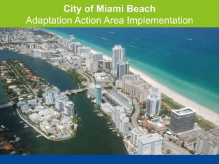
2. • Miami Beach is a low-lying,
porous barrier island with
approximately 70 miles of
shoreline
• Average elevation of 4.4 feet
NAVD 1988
• Dense, urban environment
• How do we best plan and adapt
to the impacts of Sea Level
Rise?
City of Miami Beach:
Surrounded by Water
5. Miami Beach Current Response
1. Mayor & Commission
Leadership
2. Adaptation Planning
1. Infrastructure
Improvements
2. Built Environment
3. Enhancing Natural
Features
3. Long-Term Adaptation
Planning
6. Fostering Partnerships
• Southeast Florida Regional Climate Change Compact
• Academic: FIU & UM
• Engineering Expertise
• AECOM – Peer review for SWMMP
• Bechtel – Financing seawall upgrade
• International Collaboration
• Dutch Dialogues Seminar 2013
• Municipal Engineering Foundation Victoria, Australia
7. Thank you
Elizabeth Wheaton
Assistant Building Director
Environment & Sustainability Division
elizabethwheaton@miamibeachfl.gov
305-673-7000 x6121
Margarita Wells
Environment and Sustainability Specialist
Environment & Sustainability Division
margaritawells@miamibeachfl.gov
305-673-7000 x6928
Editor's Notes
According to Section 163.3164(1), Florida Statutes: ‘Adaptation action area’ or ‘adaptation area’ means a designation in the coastal management element of a local government’s comprehensive plan which identifies one or more areas that experience coastal flooding due to extreme high tides and storm surge, and that are vulnerable to the related impacts of rising sea levels for the purpose of prioritizing funding for infrastructure needs and adaptation planning.
City is located on a series of natural and man-made barrier islands between the Atlantic Ocean and Biscayne Bay.
Miami Beach is approximate 7 sq miles with a population approximately 90K and daily average population 250K
City’s Comprehensive Plan does not currently define Adaptation Action Area. However, the City has already begun to take action to adapt to the challenges posed by SLR.
Challenges range from physical challenges experienced by most barrier islands to unique problems specific to our City.
SLR is not an abstract concept, it is a challenge that CMB is facing NOW
Topography & Geology
Beach Erosion
High groundwater
Infrastructure – Including utilities, building height, building designs
Historic Preservation
Reliable Data used to make planning and design decisions
Vulnerable Population
Sub-tropical Climate
Hurricanes & tropical storms – potential for stronger more frequent events
Evaluated the groundwater table in CMB & identified that CMB groundwater is tidal and the water table is very close to the surface so soil has a low storage potential
Areas in yellow or red are a concern NOW. The groundwater is tidally influenced, when we experience high tides there is less room for water storage. This becomes particularly problematic when coupled with a rain event. October has some of the highest tides of the year. Full moon next Friday. We anticipate seeing high tides
ROOT ISSUE: Where can the water go?
Mayor’s Blue Ribbon Panel on Flooding and Sea Level Rise
Flooding Mitigation Committee
Develop immediate, mid-term and long-term flooding solutions, such as new design criteria and building codes, that take sea level rise into account.
Policy ideas discussed in these Committees and Panels include base flood elevations for public and private properties, seawall minimum height requirements, and prioritization recommendations for infrastructure upgrades.
Stormwater Management Master Plan
Updating design standards to include:
Sea Level Rise Projections
Local Groundwater Hydrology Data
Zoning Codes
Finished Floor Elevations
Beach Renourishment / Dune Enhancement / Living Shorelines
Long-term adaptation plans
Focus on flexible, low-regret strategies
Accommodate a changing environment and a diverse community
- Golf Course
Pool expertise and foster partnerships to develop solutions to the challenges facing our City.
Flood Monitoring and Modeling
Beach Erosion and Nourishment
Ground Water Monitoring and Modeling
Seawall Design
Infrastructure/Built Environment Adaptation and Building Standards
Ecosystem Services/Monitoring Architecture/Historical Properties/Urban Design
Scenarios and Risk Sensitivity (i.e. Thresholds)
Financing Communications
Flexibility to define and respond to adaptation opportunities
City landscape can shift based on natural disasters
Bolster resilience
Increase sustainability
Maintain high quality of life for all of Miami Beach’s residents, businesses and visitors
Thrive, not just survive
Flexibility to define and respond to adaptation opportunities
City landscape can shift based on natural disasters
Bolster resilience
Increase sustainability
Maintain high quality of life for all of Miami Beach’s residents, businesses and visitors
Thrive, not just survive