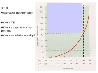
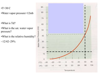
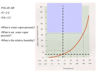
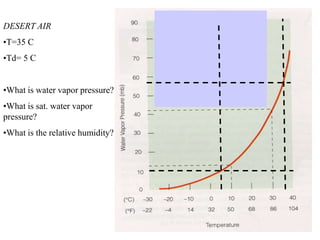
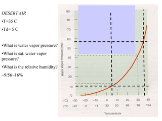
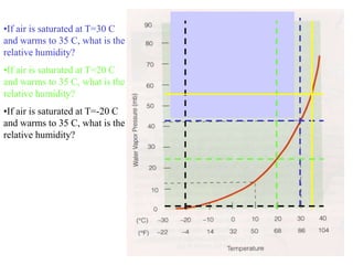
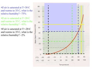
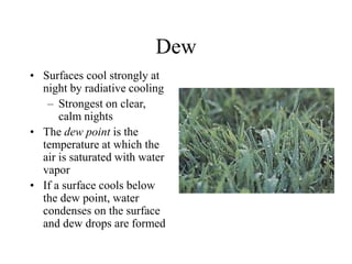
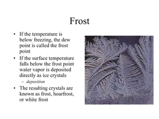
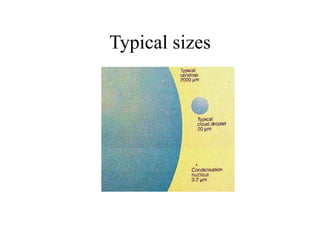
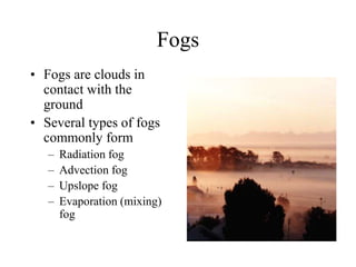
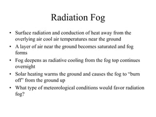
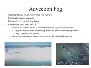
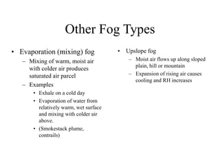
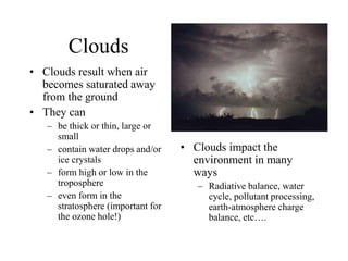
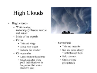
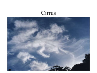
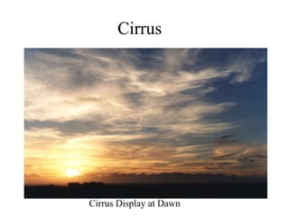
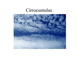
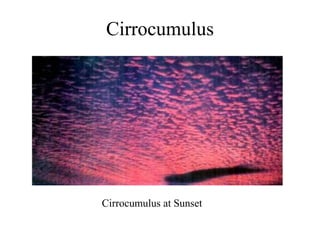
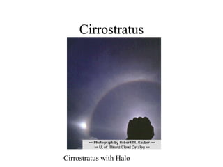
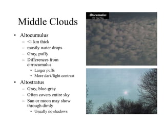
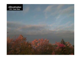
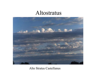
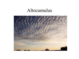
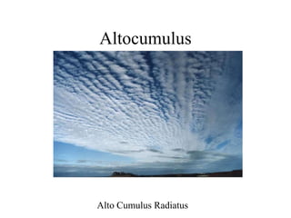
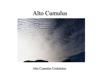
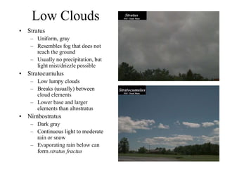
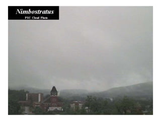
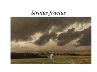
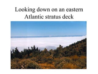
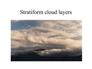
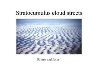
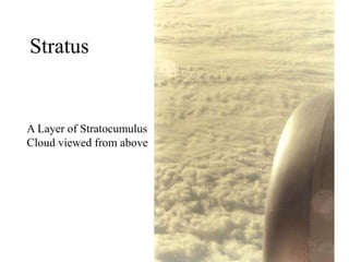
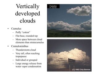
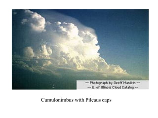
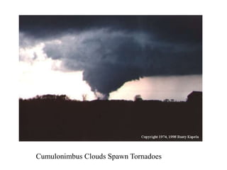
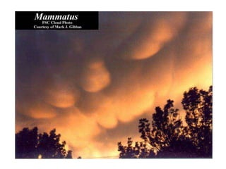
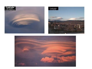
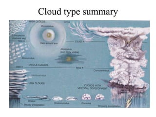
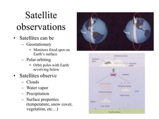
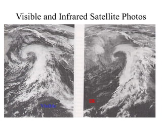
Condensation: Dew, Fog and Clouds
AT350
•T=30 C
•Water vapor pressure=12mb
•What is Td?
•What is the sat. water vapor
pressure?
•What is the relative humidity?
•T=30 C
•Water vapor pressure=12mb
•What is Td?
•What is the sat. water vapor
pressure?
•What is the relative humidity?
~12/42~29%
POLAR AIR
•T=-2 C
•Td=-2 C
•What is water vapor pressure?
•What is sat. water vapor
pressure?
•What is the relative humidity?
DESERT AIR
•T=35 C
•Td= 5 C
•What is water vapor pressure?
•What is sat. water vapor
pressure?
•What is the relative humidity?
DESERT AIR
•T=35 C
•Td= 5 C
•What is water vapor pressure?
•What is sat. water vapor
pressure?
•What is the relative humidity?
~9/56~16%
•If air is saturated at T=30 C
and warms to 35 C, what is the
relative humidity?
•If air is saturated at T=20 C
and warms to 35 C, what is the
relative humidity?
•If air is saturated at T=-20 C
and warms to 35 C, what is the
relative humidity?
•If air is saturated at T=30 C
and warms to 35 C, what is the
relative humidity? ~75%
•If air is saturated at T=20 C
and warms to 35 C, what is the
relative humidity? ~43%
•If air is saturated at T=-20 C
and warms to 35 C, what is the
relative humidity? ~2%
Condensation
• Condensation is the phase transformation of
water vapor to liquid water
• Water does not easily condense without a
surface present
– Vegetation, soil, buildings provide surface for
dew and frost formation
– Particles act as sites for cloud and fog drop
formation
Dew
• Surfaces cool strongly at
night by radiative cooling
– Strongest on clear,
calm nights
• The dew point is the
temperature at which the
air is saturated with water
vapor
• If a surface cools below
the dew point, water
condenses on the surface
and dew drops are formed
Frost
• If the temperature is
below freezing, the dew
point is called the frost
point
• If the surface temperature
falls below the frost point
water vapor is deposited
directly as ice crystals
– deposition
• The resulting crystals are
known as frost, hoarfrost,
or white frost
Cloud and fog drop formation
• If the air temperature cools below the dew point
(RH > 100%), water vapor will tend to condense
and form cloud/fog drops
• Drop formation occurs on particles known as
cloud condensation nuclei (CCN)
• The most effective CCN are water soluble.
• Without particles clouds would not form in the
atmosphere
– RH of several hundred percent required for pure
water drop formation
Typical sizes
Fogs
• Fogs are clouds in
contact with the
ground
• Several types of fogs
commonly form
– Radiation fog
– Advection fog
– Upslope fog
– Evaporation (mixing)
fog
Radiation Fog
• Surface radiation and conduction of heat away from the
overlying air cool air temperatures near the ground
• A layer of air near the ground becomes saturated and fog
forms
• Fog deepens as radiative cooling from the fog top continues
overnight
• Solar heating warms the ground and causes the fog to “burn
off” from the ground up
• What type of meteorological conditions would favor radiation
fog?
Advection Fog
• Warm air moves (is advected) over cold surface
• Cold surface cools warm air
• If saturation is reached, fog forms
• Common on west coast of U.S.
– Warm moist air from Pacific is advected over upwelling cold coastal waters
– As foggy air moves ashore, solar heating warms the ground and overlying surface
• Fog evaporates near ground
– Coastal advection fogs are key moisture sources for California Redwoods
Other Fog Types
• Upslope fog
– Moist air flows up along sloped
plain, hill or mountain
– Expansion of rising air causes
cooling and RH increases
• Evaporation (mixing) fog
– Mixing of warm, moist air
with colder air produces
saturated air parcel
– Examples
• Exhale on a cold day
• Evaporation of water from
relatively warm, wet surface
and mixing with colder air
above.
• (Smokestack plume,
contrails)
Clouds
• Clouds result when air
becomes saturated away
from the ground
• They can
– be thick or thin, large or
small
– contain water drops and/or
ice crystals
– form high or low in the
troposphere
– even form in the
stratosphere (important for
the ozone hole!)
• Clouds impact the
environment in many
ways
– Radiative balance, water
cycle, pollutant processing,
earth-atmosphere charge
balance, etc….
Cloud classification
• Clouds are categorized by their height, appearance
and vertical development
– High Clouds - generally above 16,000 ft at middle latitudes
• Main types - Cirrus, Cirrostratus, Cirrocumulus
– Middle Clouds – 7,000-23,000 feet
• Main types – Altostratus, Altocumulus
– Low Clouds - below 7,000 ft
• Main types – Stratus, stratocumulus, nimbostratus
– Vertically developed clouds (via convection)
• Main types – Cumulus, Cumulonimbus
High Clouds
• High clouds
– White in day;
red/orange/yellow at sunrise
and sunset
– Made of ice crystals
– Cirrus
• Thin and wispy
• Move west to east
• Indicate fair weather
– Cirrocumulus
• Less common than cirrus
• Small, rounded white
puffs individually or in
long rows (fish scales;
mackerel sky)
– Cirrostratus
• Thin and sheetlike
• Sun and moon clearly
visible through them
• Halo common
• Often precede
precipitation
Cirrus
Cirrus
Cirrus Display at Dawn
Cirrocumulus
Cirrocumulus
Cirrocumulus at Sunset
Cirrostratus
Cirrostratus with Halo
Middle Clouds
• Altocumulus
– <1 km thick
– mostly water drops
– Gray, puffy
– Differences from
cirrocumulus
• Larger puffs
• More dark/light contrast
• Altostratus
– Gray, blue-gray
– Often covers entire sky
– Sun or moon may show
through dimly
• Usually no shadows
Altostratus
Alto Stratus Castellanus
Altocumulus
Altocumulus
Alto Cumulus Radiatus
Alto Cumulus
Alto Cumulus Undulatus
Low Clouds
• Stratus
– Uniform, gray
– Resembles fog that does not
reach the ground
– Usually no precipitation, but
light mist/drizzle possible
• Stratocumulus
– Low lumpy clouds
– Breaks (usually) between
cloud elements
– Lower base and larger
elements than altostratus
• Nimbostratus
– Dark gray
– Continuous light to moderate
rain or snow
– Evaporating rain below can
form stratus fractus
Stratus fractus
Looking down on an eastern
Atlantic stratus deck
Stratiform cloud layers
Stratocumulus cloud streets
Stratus undulatus
Stratus
A Layer of Stratocumulus
Cloud viewed from above
Vertically
developed
clouds
• Cumulus
– Puffy “cotton”
– Flat base, rounded top
– More space between cloud
elements than stratocumulus
• Cumulonimbus
– Thunderstorm cloud
– Very tall, often reaching
tropopause
– Individual or grouped
– Large energy release from
water vapor condensation
Cumulonimbus with Pileaus caps
Cumulonimbus Clouds Spawn Tornadoes
Cloud type summary
Satellite
observations
• Satellites can be
– Geostationary
• Monitors fixed spot on
Earth’s surface
– Polar orbiting
• Orbit poles with Earth
revolving below
• Satellites observe
– Clouds
– Water vapor
– Precipitation
– Surface properties
(temperature, snow cover,
vegetation, etc…)
Visible and Infrared Satellite Photos
Visible
IR

Lecture_FogCloud.ppt

  • 1.
    Condensation: Dew, Fogand Clouds AT350
  • 2.
    •T=30 C •Water vaporpressure=12mb •What is Td? •What is the sat. water vapor pressure? •What is the relative humidity?
  • 3.
    •T=30 C •Water vaporpressure=12mb •What is Td? •What is the sat. water vapor pressure? •What is the relative humidity? ~12/42~29%
  • 4.
    POLAR AIR •T=-2 C •Td=-2C •What is water vapor pressure? •What is sat. water vapor pressure? •What is the relative humidity?
  • 5.
    DESERT AIR •T=35 C •Td=5 C •What is water vapor pressure? •What is sat. water vapor pressure? •What is the relative humidity?
  • 6.
    DESERT AIR •T=35 C •Td=5 C •What is water vapor pressure? •What is sat. water vapor pressure? •What is the relative humidity? ~9/56~16%
  • 7.
    •If air issaturated at T=30 C and warms to 35 C, what is the relative humidity? •If air is saturated at T=20 C and warms to 35 C, what is the relative humidity? •If air is saturated at T=-20 C and warms to 35 C, what is the relative humidity?
  • 8.
    •If air issaturated at T=30 C and warms to 35 C, what is the relative humidity? ~75% •If air is saturated at T=20 C and warms to 35 C, what is the relative humidity? ~43% •If air is saturated at T=-20 C and warms to 35 C, what is the relative humidity? ~2%
  • 9.
    Condensation • Condensation isthe phase transformation of water vapor to liquid water • Water does not easily condense without a surface present – Vegetation, soil, buildings provide surface for dew and frost formation – Particles act as sites for cloud and fog drop formation
  • 10.
    Dew • Surfaces coolstrongly at night by radiative cooling – Strongest on clear, calm nights • The dew point is the temperature at which the air is saturated with water vapor • If a surface cools below the dew point, water condenses on the surface and dew drops are formed
  • 11.
    Frost • If thetemperature is below freezing, the dew point is called the frost point • If the surface temperature falls below the frost point water vapor is deposited directly as ice crystals – deposition • The resulting crystals are known as frost, hoarfrost, or white frost
  • 12.
    Cloud and fogdrop formation • If the air temperature cools below the dew point (RH > 100%), water vapor will tend to condense and form cloud/fog drops • Drop formation occurs on particles known as cloud condensation nuclei (CCN) • The most effective CCN are water soluble. • Without particles clouds would not form in the atmosphere – RH of several hundred percent required for pure water drop formation
  • 13.
  • 14.
    Fogs • Fogs areclouds in contact with the ground • Several types of fogs commonly form – Radiation fog – Advection fog – Upslope fog – Evaporation (mixing) fog
  • 15.
    Radiation Fog • Surfaceradiation and conduction of heat away from the overlying air cool air temperatures near the ground • A layer of air near the ground becomes saturated and fog forms • Fog deepens as radiative cooling from the fog top continues overnight • Solar heating warms the ground and causes the fog to “burn off” from the ground up • What type of meteorological conditions would favor radiation fog?
  • 16.
    Advection Fog • Warmair moves (is advected) over cold surface • Cold surface cools warm air • If saturation is reached, fog forms • Common on west coast of U.S. – Warm moist air from Pacific is advected over upwelling cold coastal waters – As foggy air moves ashore, solar heating warms the ground and overlying surface • Fog evaporates near ground – Coastal advection fogs are key moisture sources for California Redwoods
  • 17.
    Other Fog Types •Upslope fog – Moist air flows up along sloped plain, hill or mountain – Expansion of rising air causes cooling and RH increases • Evaporation (mixing) fog – Mixing of warm, moist air with colder air produces saturated air parcel – Examples • Exhale on a cold day • Evaporation of water from relatively warm, wet surface and mixing with colder air above. • (Smokestack plume, contrails)
  • 18.
    Clouds • Clouds resultwhen air becomes saturated away from the ground • They can – be thick or thin, large or small – contain water drops and/or ice crystals – form high or low in the troposphere – even form in the stratosphere (important for the ozone hole!) • Clouds impact the environment in many ways – Radiative balance, water cycle, pollutant processing, earth-atmosphere charge balance, etc….
  • 19.
    Cloud classification • Cloudsare categorized by their height, appearance and vertical development – High Clouds - generally above 16,000 ft at middle latitudes • Main types - Cirrus, Cirrostratus, Cirrocumulus – Middle Clouds – 7,000-23,000 feet • Main types – Altostratus, Altocumulus – Low Clouds - below 7,000 ft • Main types – Stratus, stratocumulus, nimbostratus – Vertically developed clouds (via convection) • Main types – Cumulus, Cumulonimbus
  • 20.
    High Clouds • Highclouds – White in day; red/orange/yellow at sunrise and sunset – Made of ice crystals – Cirrus • Thin and wispy • Move west to east • Indicate fair weather – Cirrocumulus • Less common than cirrus • Small, rounded white puffs individually or in long rows (fish scales; mackerel sky) – Cirrostratus • Thin and sheetlike • Sun and moon clearly visible through them • Halo common • Often precede precipitation
  • 21.
  • 22.
  • 23.
  • 24.
  • 25.
  • 26.
    Middle Clouds • Altocumulus –<1 km thick – mostly water drops – Gray, puffy – Differences from cirrocumulus • Larger puffs • More dark/light contrast • Altostratus – Gray, blue-gray – Often covers entire sky – Sun or moon may show through dimly • Usually no shadows
  • 28.
  • 29.
  • 30.
  • 31.
  • 32.
    Low Clouds • Stratus –Uniform, gray – Resembles fog that does not reach the ground – Usually no precipitation, but light mist/drizzle possible • Stratocumulus – Low lumpy clouds – Breaks (usually) between cloud elements – Lower base and larger elements than altostratus • Nimbostratus – Dark gray – Continuous light to moderate rain or snow – Evaporating rain below can form stratus fractus
  • 34.
  • 35.
    Looking down onan eastern Atlantic stratus deck
  • 36.
  • 37.
  • 38.
    Stratus A Layer ofStratocumulus Cloud viewed from above
  • 39.
    Vertically developed clouds • Cumulus – Puffy“cotton” – Flat base, rounded top – More space between cloud elements than stratocumulus • Cumulonimbus – Thunderstorm cloud – Very tall, often reaching tropopause – Individual or grouped – Large energy release from water vapor condensation
  • 40.
  • 41.
  • 44.
  • 45.
    Satellite observations • Satellites canbe – Geostationary • Monitors fixed spot on Earth’s surface – Polar orbiting • Orbit poles with Earth revolving below • Satellites observe – Clouds – Water vapor – Precipitation – Surface properties (temperature, snow cover, vegetation, etc…)
  • 46.
    Visible and InfraredSatellite Photos Visible IR