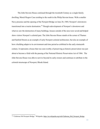
Download to read offline

![8
Upon his death in 1817, his wife Mary became administrator of his estate in 1817.31
However by
1825, Mary was removed as administer and Christopher E. Robbins became administrator
through the Probate Court.32
His personal estate was worth only $54.50 in July of 1825, down
from $129.33 when it was assessed in 1817.33
Much of Stevens estate was sold at auction
through Robbins administration and John’s son James Stevens purchased the property on April
13, 1827.34
From 1827 through 1859 the property title transfers between James Stevens and Sarah
Sherman three times. James Stevens was a civil engineer and surveyor and may have lived in the
property, then known as 224 Thames Street, from 1827 to around 1840. Little is known about
Sarah Sherman except she was a map printer, so it is possible James and Sarah knew each other
through their trades.35
Sarah is listed as having one son and is beneath James in an 1840 census
showing that they may have lived in the same building or close to each other.36
By 1856 James
was living at 38 Prospect Hill.37
James’ ownership of the house was tumultuous as he appears to have lived close to
bankruptcy like his father. James sold the house to Sarah Sherman in 1835 but buys it back in
March 6,1836. On April 2, 1836, James took out an ad in The Newport Mercury asking those
who owed him bills to pay half what was due and he would forgive the rest to make money
31
Land Evidence Office, City of Newport, RI Probate Book Volume 5, Page 372.
32
Land Evidence Office, City of Newport, RI Probate Book Volume 6, Page 55.
33
Land Evidence Office, City of Newport, RI Probate Book Volume 5, Page 372; Land Evidence Office, City of
Newport, RI Probate Book Volume 7, Page 67.
34
Land Evidence Office, City of Newport, RI Deed Book Volume 16, Page 497.
35
“30 Thames Street.” From Architectural Heritage of Newport Workbook.” Newport: Newport Historical Society.
36
Year: 1840; Census Place: Newport, Newport, Rhode Island; Roll: 504; Page: 164; Image: 341; Family History
Library Film: 0022260.
37
Ancestry.com, U.S. Directories, 1822-1995. [database on-line]. Provo, UT, USA,: Ancestry.com Operations, Inc.
2011.](https://image.slidesharecdn.com/6a7c8dcd-b8bb-4ff2-8350-ae0be2ad62b8-161215171855/85/John-Stevens-House-30-Thames-St-Newport-RI-A-History-9-320.jpg)
![12
On this day, Mary Massey’s car that was parking outside of 30 Thames Street was struck when
Calvin Haynes of the Naval Base fell asleep while driving.59
Police believe he had been drinking.
Her husband Milton Massey later caused an accident on South Baptist Street when he hit another
vehicle from behind, causing damage to a total of three other cars.60
The stories continue to paint
the picture that downtown Newport but not the safest part of the city.
Another resident, Bernice L. Greene, was arrested for being rowdy with friends from the
destroyer Beatty in the Crown Bar and Grille on Broadway in May of 1961.61
Bernice was the
twenty-one year old daughter of Arthur A. Greene, a janitor at the YMCA who also had served
in the Armed Services.62
She was arraigned later in February of 1962 for a similar charge of
reveling on West Broadway where she was the only one to plead guilty out of the four people
charged.63
Another tenement at this time, Alfred P. Shemo had his hubcaps returned to him in
August of 1962 after they were recovered by Middletown police when they arrested four men.64
With much turnover at the house, it is no surprise that the house’s time as a tenement was about
to come to an end. The owner of the Philip Stevens House which neighbored the property to the
south, purchased the house on December 31, 1961.65
Restoration and the Present
Urban redevelopment via historic preservation was gaining momentum in the early
sixties and the Preservation Society of Newport County was at the forefront early on. The
59
“Car Smashes Piazza As Motorist Dozes,” The Newport Daily News, January 8, 1960.
60
“Driver is Injured in Rear-End Crash,” The Newport Daily News, September 28, 1961.
61
“Newporter’s Bail Ordered Forfeited,” The Newport Daily News, May 20, 1961.
62
Ancestry.com. U.S., Social Security Applications, and Claims Index, 1936-2007 [database on-line]. Provo, UT,
USA: Ancestry.com Operations, Inc., 2015. Original data: Social Security Applications and Claims, 1936-2007.
63
“Tipsy Driving Charge Denied,” The Newport Daily News, February 3, 1962.
64
“Two Hubcaps Stolen…,” The Newport Daily News, August 17, 1962.
65
Land Evidence Office, City of Newport, RI, Deed Book Volume 207, Page 477](https://image.slidesharecdn.com/6a7c8dcd-b8bb-4ff2-8350-ae0be2ad62b8-161215171855/85/John-Stevens-House-30-Thames-St-Newport-RI-A-History-13-320.jpg)
![13
organization supported private efforts to restore old colonial houses in the city, though were
unable to take on a full neighborhood plan.66
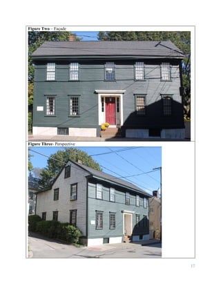
Under Muriel Rogers Case’s ownership, restrictions
were added to the house. The restrictions stated, “The exterior of the dwelling house located on
said granted premises shall be restored and preserved in a manner consistent with its original
colonial architecture. [And] that said premises shall be used for one single family dwelling house
and for no other purpose.”67
The restrictions are first mentioned in a deed granting the property
to the Preservation Society of Newport in December of 1964, but are listed to have been added
on December 31, 1963.68
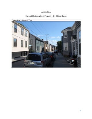
The Preservation Society of Newport County owned the home for less than a month,
giving the property to private owners for the cost of legal fees.69
The new owner Charles W.
Wharton, Jr. and Mary Wharton most likely took on the cost of restoring the house and were
granted a building permit on January 22, 1965 for extensive restorations.70
During this time a
“dilapidated ell” was removed from the east elevation and most of the house was restored. Only
the façade remained true to the house pre-restoration, though the restoration work was colonial in
style.71
The work was done in collaboration with Operation Clapboard.
Operation Clapboard was formed in 1963 by homeowners who wanted to save the many
colonial houses in Newport.72
They purchased houses by using the money raised from selling
stocks and then reselling the houses to owners who had an interest in restoration. The
organization helped the new home owners navigate and make educated decisions in regards to
66
“Historic Preservation Via Redevelopment.” Newport Daily News. Newport, R.I. October 27, 1962.
67
Land Evidence Office, City of Newport, RI Deed Book Volume 213, Page 4.
68
Land Evidence Office, City of Newport, RI Deed Book Volume 213, Page 4.
69
“Historic Property Data Sheet, Rhode Island Statewide Survey.”
70
Building Permit Office of Newport, R.I. 30 Thames St. (P-17, L-303) Muriel Rogers Case (C. W. Wharton, Jr.)
January 22, 1965
71
“Historic Property Data Sheet, Rhode Island Statewide Survey.”
72
“Art Association Shows Photos of Colonial House Restorations,” The Newport Daily News, January 10, 1969.](https://image.slidesharecdn.com/6a7c8dcd-b8bb-4ff2-8350-ae0be2ad62b8-161215171855/85/John-Stevens-House-30-Thames-St-Newport-RI-A-History-14-320.jpg)
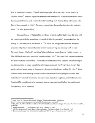
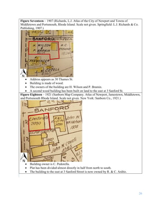
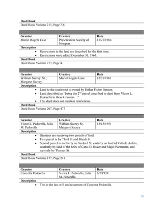
![33
Land is same boundaries but described as two lots: the easternmost lot called
the stone lot and the western part called the Homestead estate with dwelling
house thereon standing.
The stone lot is free of incumbrance except for James’ wife’s right of dower,
but the western part with dwelling house are mortgaged to John Sterne for
security.
Also said western part with dwelling house is mortgaged to Jonathan T. Almy
Esq., Merchant of Newport, for Security.
Deed Book
Deed Book Volume 24, Page 530-531
Grantor Grantee Date
Sarah Sherman James Stevens 3/29/1836
Description
Land is described as the southwest corner of Sanford Street.
Land starts at the Southwest corner of Sanford Street, then moves south on
Thames about thirty-eight feet to the north corner of Philip Stevens land, then
moves east along Philip Stevens land to the north to Sanford Street and then
back to the starting point.
Deed Book
Deed Book Volume 21, Page 42-43
Grantor Grantee Date
James Stevens Sarah Sherman 12/12/1835
Description
Boundary is described as the southwest corner of Sanford, and mirrors the
previous deed.
There is not much information given about Sarah Sherman.
Deed Book
Deed Book Volume 20, Page 580
Grantor Grantee Date
Christopher E Robbins,
Administrator de bonis on
the estate of John Stevens
[III], Stone Cutter
Deceased
James Stevens 4/13/1827
Description](https://image.slidesharecdn.com/6a7c8dcd-b8bb-4ff2-8350-ae0be2ad62b8-161215171855/85/John-Stevens-House-30-Thames-St-Newport-RI-A-History-34-320.jpg)
![37
Bibliography
Books
Guinness, Desmond and Julius Trousdale Sadler, Jr. Newport Preserv’d Architecture of the 18th
Century. New York: The Viking Press, 1982.
Building Permits
#479, Thames St. (P-17, L-303), Building Permits Office of Newport, R.I. April 16, 1997.
Building Permit Office of Newport, R.I. 30 Thames St. (P-17, L-303) Muriel Rogers Case (C. W.
Wharton, Jr.) January 22, 1965.
Census Records
Year: 1840; Census Place: Newport, Newport, Rhode Island; Roll: 504; Page: 164; Image: 341;
Family History Library Film: 0022260.
City Directories
Ancestry.com, U.S. Directories, 1822-1995. [database on-line]. Provo, UT, USA,: Ancestry.com
Operations, Inc. 2011.
Sampson, Davenport and Co. The Newport Directory 1883. (Newport: Sampson, Davenport &
Co.) 1883.
Sampson, Davenport and Co. The Newport Directory 1883. (Newport: Sampson, Davenport &
Co.) 1884.
Sampson, Davenport and Co. The Newport Directory 1901. (Newport: Sampson, Davenport &
Co.) 1901.
The Newport Directory, Providence: Sampson, Murdock, & Co., 1901-1921.
Ward, A.J. Boyd’s Newport City Directory 1878-1879. (Newport: A. Boyd) 1878.
Deeds
Land Evidence Office, City of Newport, RI Deed Book Volume 16, Page 497.
Land Evidence Office, City of Newport, R.I. Deed Book Volume 24, pages 530-531.
Land Evidence Office, City of Newport, RI Deed Book Volume 25, Page 541-542.](https://image.slidesharecdn.com/6a7c8dcd-b8bb-4ff2-8350-ae0be2ad62b8-161215171855/85/John-Stevens-House-30-Thames-St-Newport-RI-A-History-38-320.jpg)
![38
Land Evidence Office, City of Newport, RI Deed Book Volume 26, Page 565.
Land Evidence Office, City of Newport, RI Deed Book Volume 34, Page 449-451.
Land Evidence Office, City of Newport, RI, Deed Book Volume 207, Page 477.
Land Evidence Office, City of Newport, RI Deed Book Volume 213, Page 4.
Journals
Benson, Esther Fisher. “The History of the John Stevens Shop.” Bulletin of the Newport
Historical Society. 112 (October 1963).
Hall, Elton W., “The John Stevens Shop: Three Hundred Years of Stonecutting in Newport,” The
Chronicle, 58.4, p.145-146.
Maps
Blaskowitz, Charles and Will. Faden. A Plan of the Town of Newport. September 1, 1777. Roger
Williams University Architectural Library, Bristol. Arch Map.
Beers, D.G., J.H. Goodhue and H.B. Parsell. Atlas of the State of Rhode Island. Philadelphia:
D.G. Beers & Co., 1987.
City of Newport, R.I. Survey Map Plat Records. Book 1, 85. Newport Historical Society.
Hopkins, G.M. City Atlas of Newport Rhode Island. Scale not given. Philadelphia: G.M.
Hopkins, C.E. Publishing, 1876.
Richards, L.J. Atlas of the City of Newport and Towns of Middletown and Portsmouth, Rhode
Island. Springfield: L.J. Richards & Co. Publishing, 1907.
Sanborn Map Company. Atlas of Newport, Jamestown, Middletown, and Portsmouth Rhode
Island. Scale not given. New York: Sanborn Co., 1921.
Sanborn Co. Insurance Maps of Newport.
http://sanborn.umi.com.rwulib.idm.oclc.org/sanborn/image (Accessed Sept. 16, 2016)
Miscellaneous
Ancestry.com. U.S., Social Security Applications, and Claims Index, 1936-2007 [database on-
line]. Provo, UT, USA: Ancestry.com Operations, Inc., 2015. Original data: Social Security
Applications and Claims, 1936-2007.
“Architectural Heritage of Newport Workbook.” Newport: Newport Historical Society.](https://image.slidesharecdn.com/6a7c8dcd-b8bb-4ff2-8350-ae0be2ad62b8-161215171855/85/John-Stevens-House-30-Thames-St-Newport-RI-A-History-39-320.jpg)

This document provides an architectural analysis of the John Stevens House located at 30 Thames Street in Newport, Rhode Island. It details the history of the property from its original granting to John Stevens I in 1705 through its use as a single-family home again after a 1965 restoration. The document describes the architectural features and evolution of the building over time. It analyzes maps, deeds, census records and other documents to trace the ownership and uses of the property when owned by multiple generations of the Stevens family who operated a stonecutting business on the site from the early 1700s.