SlideShare a Scribd company logo
Unlimited distribution
Distribution unlimited. for public release
A CNA Occasional Paper
China versus Vietnam:
An Analysis of the Competing Claims
in the South China Sea
Raul (Pete) Pedrozo
With a Foreword by CNA Senior Fellow Michael McDevitt
August 2014
Copyright © 2014 CNA
This document contains the best opinion of the authors at the time of issue.
It does not necessarily represent the opinion of the sponsor.
Cover Photo: South China Sea Claims and Agreements. Source: U.S. Department of
Defense’s Annual Report on China to Congress, 2012.
Distribution
Distribution unlimited. Specific authority contracting number: E13PC00009.
Copyright © 2014 CNA
This work was created in the performance of Contract Number 2013-9114. Any
copyright in this work is subject to the Government's Unlimited Rights license as defined
in FAR 52-227.14. The reproduction of this work for commercial purposes is strictly
prohibited. Nongovernmental users may copy and distribute this document in any
medium, either commercially or noncommercially, provided that this copyright notice is
reproduced in all copies. Nongovernmental users may not use technical measures to
obstruct or control the reading or further copying of the copies they make or distribute.
Nongovernmental users may not accept compensation of any manner in exchange for
copies. All other rights reserved.
This project was made possible by a generous grant from the Smith Richardson
Foundation
Approved by: August 2014
Ken E. Gause, Director
International Affairs Group
Center for Strategic Studies
FOREWORD
This legal analysis was commissioned as part of a project entitled, “U.S. policy options in 
the South China Sea.” The objective in asking experienced U.S international lawyers, such as 
Captain Raul “Pete” Pedrozo, USN, Judge Advocate Corps (ret.),1
 the author of this analysis, is to 
provide  U.S.  policy  makers  access  to  work  that  tests  the  various  legal  arguments  that  the 
respective  claimants  make  in  support  of  their  claims,  and  weigh  them  against  the  relatively 
limited body of international case law associated with maritime disputes of this sort. 
 
Importantly, this analysis of Vietnamese claims versus Chinese claims to the Paracel and 
Spratly archipelagoes was not undertaken as a prelude to a recommendation that the United 
States  depart  from  its  long  held  position  of  not  taking  a  position  on  competing  sovereignty 
claims in the South China Sea. That is not the intent, nor is it one of the recommendations of 
the project. 
 
Captain Pedrozo’s findings are summarized below: 
 
Based  on  the  arguments  and  evidence  submitted  by  the  claimants  and  general 
principles  of  international  law  related  to  the acquisition  of  territory,  it  would  appear 
that Vietnam clearly has a superior claim to the South China Sea islands. 
 
Vietnam’s title to the Paracels is well founded in both history and law. Beginning in the 
early 18th
 century, Vietnam demonstrated a clear intent to assert sovereignty over the 
islands through the establishment of a government‐sponsored company to exploit and 
manage the resources of the archipelago. That intent was confirmed by the annexation 
of the islands and symbolic acts of sovereignty in the early 19th
 century, followed by 
peaceful, effective, and continuous administration of the islands by successive Nguyen 
dynasties until the advent of the French colonial period. France continued to effectively 
administer the islands on behalf of Vietnam and physically took possession and occupied 
the Paracels in the 1930s. Thereafter, France continued to assert its sovereignty over 
the  Paracels  until  its  departure  from  Indochina  in  1956.  Following  the  French 
withdrawal,  South  Vietnam  (and  subsequently  a  united  Vietnam)  effectively 
administered the islands and never ceased to assert Vietnamese sovereignty over the 
archipelago, even after China illegally occupied a portion of the islands in 1956 and the 
entire archipelago in 1974. 
 
On the other hand, the first demonstration of Chinese sovereignty over the Paracels did 
not occur until 1909, two centuries after Vietnam had legally and effectively established 
                                                            
1
 Captain Raul (Pete) Pedrozo, U.S. Navy (Ret.). Former Professor of International Law, U.S. Naval War College; Staff 
Judge Advocate, U.S. Pacific Command; and Special Assistant to the Under Secretary of Defense for Policy. The 
views expressed in this paper do not reflect the views of the U.S. government, the U.S. Department of Defense, or 
the U.S. Navy. 
 
ii 
 
its title to the islands. Moreover, China’s illegal occupation of Woody Island in 1956, and 
its occupation of the entire archipelago by force in 1974, clearly violate Article 2(4) of 
the UN Charter and accordingly do not confer a clear legal title to the Paracels. 
 
With regard to the Spratlys, France annexed the islands as terra nullius in the 1930s—at 
the  time,  occupation  by  force  was  a  valid  method  of  acquiring  sovereignty  over 
territory. Great Britain, which had controlled some of the Spratly Islands in the 1800s, 
abandoned  its  claims  following  the  French  annexation  and  effective  occupation,  so 
French  title  to  the  Spratlys  was  legally  and  soundly  established.  France’s  title  to  the 
archipelago  was  ceded  to  South  Vietnam  in  the  1950s  and  the  South  Vietnamese 
government (and subsequently a united Vietnam) effectively and peacefully controlled 
the  islands  until  ROC  forces  illegally  occupied  Itu  Aba  Island  in  1956  and  PRC  forces 
illegally occupied a number of islets in the archipelago in 1988. 
   
The ROC’s occupation of Itu Aba Island in 1946 and 1956, and the PRC’s invasion of the 
Spratlys in 1988, violate Article 2(4) of the UN Charter and cannot confer clear title to 
the  Spratlys  to  either  Taiwan  or  China.  The  fact  that  China  may  have  challenged 
Vietnamese  sovereignty  over  the  Spratlys  between  1951  and  1988,  rights  that  were 
legally ceded by France to Vietnam, does not in and of itself create a clear title for China.  
 
The  Pedrozo  analysis  differs  in  part  from  two  other  third  party  analyses,  one  by  Dr. 
Marwyn S. Samuels, an American scholar, who wrote the first detailed study on the origins of 
the  disputes  among  China,  Vietnam  and  in  the  Philippines.  A  meticulous  scholar  who  used 
Vietnam and Chinese sources, his Contest for the South China, holds up very well some 40 years 
later.2
 Samuels concluded that China had the better claim to the Paracels, but that China’s claim 
to the Spratly’s was “highly questionable.”3
 His judgments were partially echoed by Australian 
scholar  Dr.  Greg  Austin,  who  has  legal  training.  In  his  well‐regarded  China’s  Ocean  Frontier, 
published in 1998.4
 Austin found that China had “superior rights in the Paracels,” but the legal 
complexity of the disputed Spratly claims meant that, “PRC claims to the entire Spratly group 
are at least equal to any other.”5
 
 
Pedrozo’s  findings  are  supported  by  Professor  Monique  Chemillier‐Gendreau  in  her 
work, Sovereignty over the Paracel and Spratly Islands. Professor Chemllier‐Gendreau is a legal 
scholar and Professor Emeritus at Paris University‐Diderot.6
 
 
In reviewing all of these works, it is clear to me that in the unlikely event these claims 
are ever taken to the International Court of Justice to resolve the disputes over sovereignty the 
                                                            
2
 Marwyn S. Samuels, Contest for the South China Sea, Methuen New York, 1982. 
3
 Ibid, p. 68. 
4
 Greg Austin, China’s Ocean Frontier: International Law, Military Force, and National Development, Allen and 
Unwin, NSW, Australia, 1998.  
5
 Ibid, p. 161. 
6
 Monique Chemilleir‐Gendreau, Sovereignty over the Paracel and Spratly Islands, Springer (English translation), 
2000.  
iii 
 
process will be long and difficult. None of the claimants has what might be called an “open and 
shut” legal case—although the consensus among scholars seems to be that China’s claims in the 
Spratlys are weaker than those to the Paracels. 
 
The reality on the ground is that China has occupied the entire Paracel group for 40 
years, and short of military action by Vietnam to recapture the archipelago, will never leave. 
The  issue  is  more  complicated  in  the  Spratlys.  China,  Taiwan,  Vietnam,  Malaysia  and  the 
Philippines all permanently occupy features in the Spratly group. Resolution of the dispute is 
likely in only four ways: judicial arbitration that all parties agree to undertake; all parties agree 
to  freeze  in  place  while  tabling  the  issue  of  ultimate  sovereignty  in  favor  of  a  cooperative 
regime for resource exploitation and management; individual claimants reach an understanding 
with China ceding sovereignty claims in return for economic preference; or the use of force by 
the most powerful to expel rival claimants.  
 
 
                                            Michael McDevitt 
                                            Senior Fellow and Project Director 


iv 


This page intentionally left blank 


v 
 
Table of Contents 
I. INTRODUCTION ........................................................................................................................................ 1
 
II. ACQUISITION OF TERRITORY ................................................................................................................... 3
 
III. CHINA .................................................................................................................................................... 5
 
A. Chinese Claims ............................................................................................................................. 5 
1. Historical Evidence ............................................................................................................................ 5 
2. Economic Development .................................................................................................................... 8 
3. Effective Administration ................................................................................................................. 12 
   a. Naval Patrols ................................................................................................................................ 12 
   b. Administrative Control ................................................................................................................. 14 
   c. Persistent Objector ....................................................................................................................... 19 
   d. Reaffirming Sovereignty ............................................................................................................... 23 
   e. Military Intervention ..................................................................................................................... 24 
4. International Recognition ............................................................................................................... 25 
   a. The Sino‐French Treaty of 1887 .................................................................................................... 25 
   b. French Recognition before World War II ...................................................................................... 26 
   c. French Recognition after World War II ......................................................................................... 28 
   d. Japanese Recognition ................................................................................................................... 29 
   e. World War II Documents .............................................................................................................. 30 
   f. Post‐War Occupation .................................................................................................................... 30 
   g. San Francisco Peace Conference .................................................................................................. 31 
   h. International Civil Aviation Organization (ICAO) Conference ....................................................... 33 
   i. North Vietnamese Indifference...................................................................................................... 34 
   j. Other Supporting Publications....................................................................................................... 35 
IV. VIETNAM ............................................................................................................................................. 37
 
A. Vietnam Claims .......................................................................................................................... 37 
1. Historical Evidence .......................................................................................................................... 37 
2. Economic Development .................................................................................................................. 40 
3. Effective Administration ................................................................................................................. 43 
   a. French Colonial Rule ..................................................................................................................... 45 
   b. Return to South Vietnamese Control ............................................................................................ 53 
   c. Post‐unification Administration .................................................................................................... 58 
4. Right of Cession ............................................................................................................................... 61 
5. International Recognition ............................................................................................................... 61 
V. CONCLUDING ANALYSIS ........................................................................................................................ 64
 
A. Evaluation of China’s Position .................................................................................................... 64 
1. Discovery versus Awareness ........................................................................................................... 64 
vi 
 
2. Probative Value of Historic Maps.................................................................................................... 67 
3. Inchoate Title and Effective Occupation ......................................................................................... 69 
   a. Remote and Uninhabited Territories ............................................................................................ 76 
   b. Suzerain and Vassal ...................................................................................................................... 79 
4. Persistent Objector ......................................................................................................................... 80 
5. International Recognition ............................................................................................................... 85 
   a. The Sino‐French Treaty of 1887 .................................................................................................... 85 
   b. French Recognition before World War II ...................................................................................... 87 
   c. French Recognition after World War II ......................................................................................... 93 
   d. Japanese Recognition ................................................................................................................... 94 
   e. World War II Documents .............................................................................................................. 96 
   f. Post‐War Occupation .................................................................................................................... 98 
   g. San Francisco Peace Conference .................................................................................................. 99 
   h. International Civil Aviation Organization (ICAO) Conference ..................................................... 104 
   i. North Vietnamese Indifference.................................................................................................... 104 
   j. Other Supporting Publications..................................................................................................... 108 
B. Evaluating Vietnam’s Position .................................................................................................. 108 
1. Historical Evidence and Maps ....................................................................................................... 109 
2. Economic Development ................................................................................................................ 111 
3. Effective Occupation and Administration ..................................................................................... 112 
   a. Effective Administration During the French Colonial Period ...................................................... 113 
   b. Effective Administration by South Vietnam ............................................................................... 119 
   c. Post‐unification Administration .................................................................................................. 122 
4. Right of Cession ............................................................................................................................. 124 
5. International Recognition ............................................................................................................. 128 
C. Final Thoughts .......................................................................................................................... 130 
 
1 
 
I. INTRODUCTION*
The  South  China  Sea  stretches  from  Singapore  and  the  Strait  of  Malacca  in  the 
southwest, to the Strait of Taiwan in the northeast. It is bounded on the east by the Philippine 
Islands, on the south by Borneo, on the west by Vietnam, and on the north by mainland China. 
The area includes several hundred small islands, rocks, atolls, islets, cays, shoals, sandbars, and 
reefs. Many are underwater at high tide, while others are permanently submerged even at low 
tide. These features, most of which are uninhabitable, are situated in three island chains (the 
Spratly, Paracel, and Pratas Islands), the Macclesfield Bank, and Scarborough Shoal.  
The South China Sea links the Pacific and Indian oceans and is home to some of the 
world’s busiest and most strategically important sea lines of communication. More than half of 
the  world’s  oil  tanker  traffic  and  over  half  of  the  world’s  merchant  fleet  (by  tonnage)  sail 
through these waters every year. In addition, the South China Sea is rich in natural resources, 
including  abundant  fisheries  and  potentially  large  oil  and  natural  gas  deposits.1
  Sovereignty 
over the various land masses—and the resulting maritime zones that would flow from these 
features—would  place  many  of  these  resources  under  the  exclusive  control  of  one  nation. 
Competing claims to these resources could result in conflict, which, in turn, could affect the free 
flow of commerce through the region. Peaceful resolution of the dispute is, therefore, critical to 
maintaining regional peace and stability, as well as a vibrant world economy. 
Pratas Island2
 and the Macclesfield Bank3
 are claimed by Taiwan and China. No nation 
has challenged China’s or Taiwan’s claim to Pratas Island. However, Macclesfield Bank and its 
surrounding shoals are located beyond the territorial sea of any nation and are permanently 
submerged, even at low tide. Accordingly, these features may not be claimed by any nation. 
Although the International Court of Justice (ICJ) has stated that international law “is silent on 
the question whether low‐tide elevations can be considered to be ‘territory,’” and that there is 
no  “customary  rule  which  unequivocally  permits  or  excludes  appropriation  of  low‐tide 
elevations,” the few rules in the law of the sea that govern low‐tide elevations “do not justify a 
general  assumption  that  low‐tide  elevations  are  territory  in  the  same  sense  as  islands.”4
 
Moreover, the Court noted that “it has never been disputed that islands constitute terra firma, 
and are subject to the rules and principles of territorial acquisition; [however,] the difference in 
                                                            
*
 This analysis is authored by Captain Raul (Pete) Pedrozo, U.S. Navy (Ret.). Former Professor of International Law, 
U.S. Naval War College, Staff Judge Advocate, U.S. Pacific Command, and Special Assistant to the Under Secretary 
of Defense for Policy. The views expressed in this paper do not reflect the views of the U.S. government, the U.S. 
Department of Defense, or the U.S. Navy. 
1
 South China Sea Report, U.S. ENERGY INFORMATION ADMINISTRATION, last updated Feb. 7, 2013. 
2
 Pratas Island (20°42'N., 116°43'E.) lies 160 miles southeast of Hong Kong and is composed of sand covered with 
scrubby brush. The island is governed by Taiwan and is home to a weather station located near the center of the 
east part of the island. NATIONAL GEOSPATIAL‐INTELLIGENCE AGENCY PUBLICATION 161, Sailing Directions (Enroute), South 
China Sea and the Gulf of Thailand, Thirteenth Edition (2011) [hereinafter PUB. 161]. 
3
 Macclesfield Bank (15°45'N., 114°20'E.) is a submerged atoll about 75 miles long on its northeast‐southwest axis 
and about half that wide at its broadest part. Pub. 161. 
4
 Maritime Delimitation and Territorial Questions between Qatar and Bahrain, Merits, Judgment, I.C.J. Reports 
2001, p. 40, at pp. 101‐103; accord Sovereignty over Pedra Branca/Pulau Batu Puteh Middle Rocks and South Ledge 
(Malaysia/Singapore), Judgment, I.C.J. Reports 2008, p. 12, at pp. 99‐101. 
2 
 
effects which the law of the sea attributes to islands and low‐tide elevations is considerable.”5
 
Accordingly, the Court concluded that “it is thus not established that in the absence of other 
rules  and  legal  principles,  low‐tide  elevations  can,  from  the  viewpoint  of  the  acquisition  of 
sovereignty, be fully assimilated with islands or other land territory.”6
 A similar, albeit more 
persuasive, argument could be made with regard to completely submerged features, such as 
Macclesfield Bank.7
 Nonetheless, because China’s claim to Macclesfield Bank is not contested 
by Vietnam, it is not discussed in detail in this paper. 
Scarborough Shoal8
 is claimed by China, Taiwan, and the Philippines. The total area of 
the shoal, including its inner lagoon, is 150 square kilometers.9
 The reef is situated about 170 
nautical  miles  (nm)  east  of  Macclesfield  Bank,  115  nm  off  the  Philippine  island  of  Luzon 
(Zambales Province), and 472 nm from the Chinese coast.10
 China argues that it discovered the 
shoal and has exercised effective control over it for hundreds of years. The Philippines claims 
that it has effectively occupied the shoal since 1946.11
 Because the dispute over the shoal does 
not involve Vietnam, it is not discussed in detail in this paper.  
The Paracel Islands12
 are spread over a sea area of 15,000 to 16,000 square kilometers 
and are claimed by Vietnam, Taiwan, and China, but have been occupied by China since 1974. 
Most of the features in the South China Sea are in the Spratly Island13
 chain and are spread over 
160,000 to 180,000 square kilometers of ocean area. The Spratlys are claimed in their entirety 
by China, Taiwan, and Vietnam, and partially by the Philippines, Malaysia, and Brunei. All of the 
                                                            
5
 Id. 
6
 Id. 
7
 Robert Beckman, Scarborough Shoal: Flashpoint for Confrontation or Opportunity for Cooperation, RSIS 
COMMENTARIES, No. 072/2012, Apr. 24, 2012 (“…under international law, Macclesfield Bank may not be capable of 
being subject to a claim of sovereignty because it is completely submerged.”) [hereinafter RSIS COMM. No. 
072/2012]. 
8
 Scarborough Reef (Scarborough Shoal) (15°08'N., 117°45'E.) consists of a narrow belt of barely submerged reef 
enclosing a lagoon. On the belt are scattered rocks, with over 20 rocks standing 1.5 to 2.5 meters high. Fishing 
vessels from China and the Philippines frequent the reef to exploit the abundant living resources around the shoal. 
The ruins of an iron tower stand close to the above channel opening. PUB. 161. 
9
 Zou Keyuan, Scarborough Reef: A New Flashpoint in Sino‐Philippine Relations?, INTERNATIONAL BOUNDARIES RESEARCH 
UNIT BOUNDARY AND SECURITY BULLETIN 71, Summer 1999, at p. 71 [hereinafter IBRU BULL. 71]. 
10
 Id. 
11
 The Philippines’ claim is based on a number of activities, including building and operating of a lighthouse on the 
shoal in 1965, conducting a number of hydrographic surveys and marine scientific research in the waters around 
the shoal, using the shoal as an impact range for military exercises and enforcing its laws on smuggling and illegal 
fishing. RSIS COMM. No. 072/2012; see also IBRU BULL. 71, at p. 74. 
12
 The Paracel Islands (16°40'N., 112°20'E.) are made up of the Amphitrite Group, the Crescent Group, and several 
off‐lying islands and coral reefs, some of which are covered with trees or vegetation. The Amphitrite Group 
(16°53'N., 112°17'E.) is the northeasternmost cluster of islands, reefs, and shoals in the Paracels. The Crescent 
Group lies 45 miles southwest of the Amphitrite Group and consists of several low sand islets and numerous reefs. 
The principal islands are covered with thick vegetation. PUB. 161. 
13
 The Spratly Islands lie in the southeast part of the South China Sea along an oblong area about 52,000 square 
miles in extent, northwest of the strategic Palawan Passage. The area is dotted with sunken reefs and coral atolls. 
The major axis of the area bears about 045°‐225° for a distance of 340 miles with a maximum breadth along its 
minor axis of 175 miles. PUB. 161. 
3 
 
claimants,  except  Brunei,  have  established  military  outposts  on  a  number  of  features.14
 
Vietnam occupies the most features, followed by the Philippines, China, Malaysia, and Taiwan.  
The Paracel and Spratly Islands are situated beyond the geological continental shelf of 
any of the claimant states. Waters around the Paracels can reach a depth of over 1,000 meters 
(3,280  feet),  while  the  Spratlys  are  separated  from  any  mainland  or  major  island  by  ocean 
trenches over 3,000 meters (9,842 feet) deep. Consequently, none of the claimant states can 
claim  sovereignty  over  the  islands  “on  the  grounds  that  they  belong,  in  geomorphological 
terms, to the continental shelf of any particular country.”15
 
  This paper will only examine the claims of China/Taiwan and Vietnam with regard to the 
Paracel and Spratly Islands, as all of the activities of the other claimants occurred well past the 
critical date and can therefore not be used as a basis to claim sovereignty over any of the South 
China Sea islands. That is not to say that Malaysia, Brunei, or the Philippines may not have valid 
claims  to  some  of  the  submerged  features  situated  on  their  respective  continental  shelves 
under the United Nations Convention on the Law of the Sea (UNCLOS); rather, it means that an 
analysis of those potential claims is beyond the scope of this paper. The Philippines may also 
have a valid claim to Scarborough Shoal, which is not considered part of the Spratly Islands.16
 
II. ACQUISITION OF TERRITORY
In general, territorial sovereignty can be acquired in one of five ways: accretion, cession, 
conquest, occupation, and prescription. Accretion involves the expansion of existing territory 
under  the  sovereignty  of  a  state  through  geographical  or  geological  process  (e.g.,  volcanic 
activity). Cession occurs when one state transfers its territory to another state pursuant to a 
treaty. However, “the transferee cannot receive any greater rights than those possessed by the 
transferor.”17
  Conquest—the  acquisition  of  territory  by  force—was  historically  considered  a 
lawful mode of acquiring sovereignty, but has been illegal since October 1945 following the 
entry  into  force  of  the  United  Nations  Charter  (see  Article  2(4)).18
  Prescription  involves  the 
occupation of another state’s territory over a long period of time. In order for prescription to 
apply, the occupying state must show that its display of state authority (à titre de souverain) 
                                                            
14
 The South China Sea Online Resource, available at www.southchinasea.org/; see also Michael Bennett, The 
People’s Republic of China and the Use of International Law in the Spratly Islands Dispute, 28 STAN. J. INT’L L. 425, at 
pp. 439‐440 (1997). 
15
 Monique Chemillier‐Gendreau, Sovereignty over the Paracel and Spratly Islands (Brill/Martinus Nijhoff 
Publishers, 2000), at p. 16 and Annex 18 (Note dated 8 March 1928 from Mr Bourgouin). 
16
 PUB. 161. 
17
 D. P O’Connell, Territory, INTERNATIONAL LAW 437, Vol. 1 (2nd
 ed.), Stevens & Sons, 1970 [hereinafter O’CONNELL 
INTERNATIONAL LAW (2nd
 ed.)]; see also James Crawford, Acquisition and Transfer of Territorial Sovereignty, BROWNLIE’S 
PRINCIPLES OF PUBLIC INTERNATIONAL LAW 217 (8th
 ed.), Oxford University Press, 2012 [hereinafter BROWNLIE (8th
 ed.)]. 
18
 Charter of the United Nations, June 26, 1945, Article 2(4) provides that “all members shall refrain in their 
international relations from the threat or use of force against the territorial integrity or political independence of 
any state….” Accord M. Chemillier‐Gendreau, note 15 supra. (“Wars of conquest, as a source of new sovereignty 
over a territory, are now prohibited. Conquest by force entails a situation of military occupation which is always 
illegal and which, failing an agreement concluded between the States concerned, cannot be transformed into law, 
even with the passage of time.”). 
4 
 
over the other state’s territory was public, peaceful, and uninterrupted for a long period of 
time.19
  
Finally, a state may acquire sovereignty over territory that is not under the control of 
any  other  state  (terra nullius)  to  the  extent  that  the  state  effectively  occupies  the  territory. 
Discovery alone, however, without subsequent acts of effective occupation, does not confer 
title to territory—“an inchoate title of discovery must be completed within a reasonable period 
by effective occupation of the region claimed to be discovered.”20
 Moreover, an inchoate title 
will not “…prevail over the continuous and peaceful display of authority by another State; for 
such display may prevail even over a prior, definite title put forward by another State.”21
  
A claim to sovereignty based on effective occupation “involves two elements each of 
which  must  be  shown  to  exist:  the  intention  and  will  to  act  as  sovereign,  and  some  actual 
exercise or display of such authority.”22
 As discussed in the Clipperton Island case, besides the 
animus  occupandi,  effective  occupation  requires  the  actual,  and  not  the  nominal,  taking  of 
possession. “This taking of possession consists in acts, or series of acts, by which the occupying 
state reduces to its possession the territory in question and takes steps to exercise exclusive 
authority there.”23
  
The  degree  of  actual  administration  (effectivités)  that  must  be  established  by  the 
occupying  state,  however,  may  vary,  particularly  in  cases  of  remote  and  uninhabited  areas. 
Under such circumstances, tribunals have recognized that “sovereignty cannot be exercised in 
fact  at  every  moment  on  every  point  of  a  territory”  and  that  “[t]he  intermittence  and 
discontinuity  compatible  with  the  maintenance  of  the  right  necessarily  differ  according  as 
inhabited  or  uninhabited  regions  are  involved….”24
  Accordingly,  some  tribunals  have  “been 
satisfied with very little in the way of the actual exercise of sovereign rights, provided that the 
other  State  could  not  make  out  a  superior  claim…particularly…in  the  case  of  claims  to 
sovereignty  over  areas  in  thinly  populated  or  unsettled  countries.”25
  This  exception  to  the 
general rule that there must be an actual and continuous display of authority by the occupying 
state is explained in detail in the Clipperton Island case.26


19
 O’CONNELL INTERNATIONAL LAW (2nd
 ed.), at p. 423; see also BROWNLIE (8th
 ed.), at p. 216. 
20
 Island of Palmas Case (Netherlands/U.S.A.), U.N. Rep., Vol. II, p. 829 (1928), at p. 846. 
21
 Id. 
22
 Legal Status of Eastern Greenland Case (Denmark v. Norway), P.C.I.J., Series A/B, No. 53 (1933), at p. 45. 
23
 Clipperton Island Arbitration (Mexico v. France), 2 R.I.A.A. 1105 (1931), at p. 393. [The cited pages are from the 
English translation at 26 Am. J. Int’l L. 390, at 393‐394 (1932).] 
24
 Island of Palmas Case (Netherlands/U.S.A.), U.N. Rep., Vol. II, p. 829 (1928), p. 831, at p. 840. 
25
 Legal Status of Eastern Greenland Case (Denmark v. Norway), P.C.I.J., Series A/B, No. 53 (1933), at p. 46. See also 
Western Sahara Advisory Opinion, I.C.J. Reports 1975, p. 12, at p. 43. 
26
 Clipperton Island Arbitration (Mexico v. France), 2 R.I.A.A. 1105 (1931), at pp. 393‐394. [The cited pages are from 
the English translation at 26 Am. J. Int’l L. 390, at 393‐394 (1932).] (“It is beyond doubt that…the actual…taking of 
possession is a necessary condition of occupation. …Strictly speaking, and in ordinary cases, that only takes place 
when the state establishes in the territory itself an organization capable of making its laws respected. …There may 
also be cases where it is unnecessary to have recourse to this method. Thus, if a territory, by virtue of the fact that 
it was completely uninhabited, is, from the first moment when the occupying state makes its appearance there, at 
the absolute and undisputed disposition of that state, from that moment the taking of possession must be 
considered as accomplished, and the occupation is thereby completed.”) 
5 
 
III. CHINA
A.	Chinese	Claims		
China’s  position  regarding  its  sovereignty  claims  to  the  Paracel  (Xisha)  and  Spratly 
(Nansha) Islands was most recently published in June 2000 by the Ministry of Foreign Affairs 
(MFA) of the People’s Republic of China (PRC) in a document entitled The Issue of South China 
Sea.27
 In short, China’s claim of indisputable sovereignty over the Paracel and Spratly Islands 
and their adjacent waters is based on several factors, including historical evidence, economic 
development, effective administration, and international recognition.28
  
1.	Historical	Evidence		
According to the MFA, China was the first nation to discover and name the South China 
Sea islands. References to the islands appear in a number of books dating as far back as the Han 
Dynasty (206 BC‐220 AD). Yang Fu “described the geographic features of the South China Sea 
Islands…” in his book, Yiwu Zhi (Records of Rarities).29
 A famous Chinese navigator of the East 
Wu  State  of  the  Three  Kingdoms  Period  (220‐280)—General  Kang  Tai—also  mentions  the 
islands in his book entitled Funan Zhuan (Journeys to and from Phnom). The general, along with 
Zhu  Ying,  had  been  dispatched  by  Emperor  Huangwu  on  a  diplomatic  mission  to  Funan 
(present‐day Cambodia) via the South China Sea to meet with envoys from a number of states, 
including  the  State  of  Tianzhu  (present‐day  India).30
  Similarly,  hundreds  of  books  published 
during  the  Jin  (265‐410),  Tang  (618‐907),  Song  (960‐1279),  Yuan  (1271‐1368),  Ming  (1368‐
1644), and Qing (1644‐1911) Dynasties refer to the South China Sea islands. These include the 
Dao  Yi  Zhi  Lue  (Abridged  Records  of  Islands  and  Barbarians)  written  by  Wang  Dayuan,  a 
prominent Chinese navigator of the Yuan Dynasty who made numerous voyages to the South 
China Sea, and the Nanzhou Yuou Zhi (Records of Rarities in Southern Boundary) by Wan Zhen, 
which documents the encounters of Chinese sailors of the Han era (206 BC‐220 AD) with the 
                                                            
27
 Ministry of Foreign Affairs of the People’s Republic of China, The Issue of South China Sea (June 2000), 
[hereinafter MFA, The Issue of South China Sea], available at http://www.fmprc.gov.cn/eng/5767.html; 
http://www.fmprc.gov.cn/eng/5765.html; http://www.fmprc.gov.cn/eng/5773.html; 
http://www.fmprc.gov.cn/eng/5747.html; and http://www.fmprc.gov.cn/eng/5766.html. A previous version—
China’s Indisputable Sovereignty over the Xisha Islands and Nansha Islands—was published by the MFA in January 
1980. 
28
 MFA, The Issue of South China Sea; see also Su Hao, China’s Positions and Interests in the South China Sea: A 
Rational Choices in its Cooperative Policies, CENTER FOR STRATEGIC & INTERNATIONAL STUDIES, SOUTH ASIA PROGRAM, Sept. 
12, 2011; Jianming Shen, International Law Rules and Historical Evidence Supporting China’s Title to the South 
China Sea Islands, 21 HASTINGS INT’L & COMP. L. REV. 1‐75 (1997‐1998) [hereinafter Shen I]; and Jianming Shen, China’s 
Sovereignty over the South China Sea Islands: A Historical Perspective, CHINESE JIL (2002), pp. 94‐157 [hereinafter 
Shen II]. 
29
 Shen I, at p. 18. See also Brian K. Murphy, Dangerous Ground: The Spratly Islands and International Law, 1 OCEAN 
& COASTAL L.J. 187 (1994‐1995), at p. 200; Dr. Barry Hart Dubner, The Spratly “Rocks” Dispute—A “Rockapelago” 
Defies Norms of International Law, 9 TEMP. INT’L & COMP. L.J. 291 (1995), at p. 309; M. Bennett, note 14 supra, at p. 
434. 
30
 Shen I, at p. 19. 
6 
 
South China Sea islands on their return trip home from the Malay Peninsula.31
 A book published 
during the South Song Dynasty (1127‐1279)—Qiong Guan Zhi (Records of the Qiong Prefecture 
and its Jurisdiction)—likewise reflects that the Spratlys and Paracels were under the jurisdiction 
of the Qiong Prefecture (today’s Hainan Province).32
 
According to the MFA, Emperor Zhenyuan of the Tang Dynasty (785‐805) included the 
South China Sea islands in the administrative maps of the Empire. Reference to the islands can 
also be found in a number of maps, including the Hunyi Jiangli Lidai Guodu zhi Tu (Consolidated 
Map of Territories and Geography and Capitals of Past Dynasties), published during the Ming 
Dynasty, and the Geng Lu Bu (Road Map) of the Qing Dynasty.33
  
Chinese scholars likewise attribute great importance to Chinese efforts during the Song, 
Yuan, Ming, and Qing Dynasties to include the South China Sea islands in the country’s official 
maps  as  a  demonstration  of  sovereignty.  For  example,  Zhu  Fan  Tu  (Maps  of  the  Various 
Barbarian  Peoples)  of  the  North  Song  Dynasty  is  a  collection  “of  ancient  Chinese  maps  that 
referred  to  the  South  China  Sea  Islands  as  being  subject  to  the  Chinese  rulers.”34
  More 
specifically, the Zhu Fan Tu (Maps and Charts of the Various Barbarian Peoples, the North Song 
Dynasties) referred to the Spratlys and the sea area west of the Paracels as the outer limits of 
China’s maritime boundary.35
 Thus, both the Paracels and Spratlys “were within the boundary 
of the Song Empire.”36
  
According to Chinese scholars, maps published in the Yuan Dynasty included the Paracel 
and Spratly Islands as Chinese territory.37
 Similarly, during the Ming Dynasty, “official Chinese 
maps  [such  as  the  Hunyijiangli  Hdai  Guodu  zhi  Tu  (Consolidated  Map  of  Territories  and 
Geography and  Capitals  of  Past  Dynasties (1402))]  continued  to  indicate  China's sovereignty 
over the South China Sea Islands.”38
 Ming‐era maps were used by Admiral Zheng He during his 
Seven  Voyages.  Official  records  of  the  Ming  Dynasty,  such  as  Qiong  Guan  Gu  Zhi  (Ancient 
Records on the Jurisdiction of Qiongzhou Fu), also refer to Chinese jurisdiction over the Spratlys 
and Paracels.39
 In Zhengde Qiong Tai Zhi (Records of Qiong[zhou] and Tai[wan] During the Reign 
                                                            
31
 MFA, The Issue of South China Sea; see also Shen II, at pp. 111 and 113‐116; Shen I, at pp. 19, 27‐28. Historical 
evidence of the earliest Chinese presence in the Paracels can also be found in the Chronicles of the Sung Dynasty, 
“which states that the last Sung Emperor, pursued by a Yuan (Mongol) Dynasty general, fled to the Paracels in an 
attempt to reach Indo‐China.” Tao Cheng, The Dispute Over the South China Sea Islands, 10 TEX. INT’L L. J. 265 
(1975), at p. 273. 
32
 References to the Spratlys and Paracels can also be found in other Song‐related books, such as Song Hui Yao Ji 
Gao (Selected Manuscripts of the Digests of the Song Dynasties), Song Shi (The History of the Song Dynasties) and 
Zhu Fan Tu (Maps and Charts of the Various Barbarian Peoples, the North Song Dynasty). Shen II, at pp. 132‐133; 
see also Shen I, at pp. 23‐24. 
33
 MFA, The Issue of South China Sea; see also Shen II, at p. 106. 
34
 Shen II, at p. 126. 
35
 Shen I, at p. 24. 
36
 Id., at p. 26. 
37
 Some of these maps include: Yuandai Jiangyu Tu Xu (Map of the Territory of the Yuan Dynasty Illustrated); 
Shengjiao Chiang Bei Tu) of 1330 by Li Zemin, the Hunyi Jiangli Tu (Consolidated Maps of the Territory [of the Yuan 
Dynasty]) of 1380, and the Yu Di Tu (The Maps of the Territory [of Yuan]) drawn and illustrated by Zhu Siben 
(Yuan). Shen II, at pp. 126‐127; see also Shen I, at pp. 28‐29. 
38
 Shen II, at p. 127. A similar reference is contained in the Wubei Mishu Dili Fu Tu (A Geographical Map Annexed to 
the Secret Manual on Defense Preparations (1637)). Shen I, at p. 30. 
39
 Shen II, at p. 133. 
7 
 
of  Emperor  Zhengde),  Tan  Zhou  recorded  that  “the  sphere  of  jurisdiction  of  the  Qiongzhou 
Prefecture included the…Xisha Islands and Nansha Islands.”40
 
Qing Dynasty maps, such as the Sihai Zongtu (General Maps of the Four Seas), published 
in 1730 by Chen Lunjiong, continued to depict the position of the Paracels and Spratlys within 
the  Qing  boundary.41
  Chen  also  published  a  book  in  1730—Haikuo  Wenchien  Lu  (Notes  on 
Lands  Across  the  Sea)—that  described  the  geographic  positions  of  the  Spratly  and  Paracel 
Islands.42
  Qing‐era  records  (e.g.,  Records  of  Wanzhou  Subprefecture,  Records  of  Qiongzhou 
Prefecture and Guangdong Tong Zhi (General Records of Guangdong Province)) likewise reflect 
that the South China Sea islands, including the sea areas surrounding the islands, were within 
the jurisdiction of Wanzhou.43
  
A number of Chinese scholars place discovery and naming of the South China Sea islands 
much earlier in Chinese history—as far back as the Xia Dynasty (2100‐1660 BC). A book written 
during the Qin Dynasty (221‐206 BC)—Yi Zhou Shu (Scattered Books of the Zhou Dynasties)—
speaks  of  “tributes  from  the  South  Sea”  being  paid  by  the  southern  barbarians  (including 
present‐day  Vietnam)  to  the  rulers  of  the  Xia  Dynasty,  and  says  that  these  tributes  (turtles, 
pearl‐carrying  shellfish,  hawksbill  turtles,  and  other  rarities)  continued  through  the  Shang 
Dynasty (1600‐1050 BC), the Zhou Dynasties (1046‐256 BC), the Qin Dynasty (221‐206 BC) and 
                                                            
40
 Shen I, at pp. 29‐30. 
41
 Other Qing‐era maps cited in support of Chinese sovereignty over the South China Sea islands include: 
(1) Da Qing Zhong Wai Tianxia Quan Tu (The Complete Sino‐Foreign Maps of the Great Qing) of 1709; 
(2) Qing £hi Sheng Fen Tu (Individual Maps of the Provinces Directly under the Administration of the Qing 
Empire) of 1724; 
(3) Huang Qing Ge Zhi Sheng Fen Tu (Individual Maps of the Provinces Directly under the Administration of the 
Royal Qing) of 1755; 
(4) Da Qing Wan Man Titong Quan Tu (The Complete Maps of the Unified Great Qing for Ten Thousand Years) 
of 1767 charted by Zhu Xiling and revised by Huang Zhengsun; 
(5) Qing Hui Fu Zhou Xian Ting Zpng Tu (The Qing‐Charted General Maps of the Capital Cities, Prefectures, 
Counties and Tings) of 1800 charted by Xiao Feng; 
(6) Da Qing Wan Man Titong Tianxia Quan Tu (The Complete Maps of the Whole Unified Country of Great Qing 
for Ten Thousand Years) of 1803 charted by Yang Senzhong; 
(7) Da Qing Wan Man Titong Dili Quan Tu (The Complete Geographical Maps of the Unified Great Qing for Ten 
Thousand Years) of 1810; 
(8) Da Qing Titong Tianxia Quan Tu (The Complete Maps of the Whole Unified Country of Great Qing) of 1817; 
(9) Gu Jin Di Tu Quan Tu (The Complete Maps of the Lands and Territories Then and Now) of 1895; 
(10) Da Qing Tianxia Zhonghua Ge Sheng Fu Zhou Xian Ting Dili Quan Tu (The Complete Geographical Maps of 
the Provinces, Capital Cities, Prefectures, Counties and Tings of the Whole China of the Great Qing) of 1904 
charted by Wu Changfa; and  
(11) Da Qing Tianxia Zhonghua Ge Sheng Fu Zhou Xian Ting Dili Quan Tu (The Complete Geographical Maps of 
the Provinces, Capital Cities, Prefectures, Counties and Tings of the Whole China of the Great Qing) of 1905 
charted by Wang Xingshun. 
Shen II, at pp. 127‐128. A book written by Yang Bingnan in 1844—Hai Lu (Illustrations of the Sea)—records “the 
oration of Xie Qinggao, a Qing official…, in which the South China Sea islands were described in four groups…” and 
a sea chart (Yiban Lu (Particular Illustrations)) prepared by Zheng Guangzu during the same time period contains 
the locations of the “Dongsha, Zhongsha, Xisha and Nansha Islands.” Shen I, at pp. 33‐35. 
42
 Shen I, at p. 32; see also Hungdah Chiu and Choon‐Ho Park, Legal Status of the Paracel and Spratly Islands, OCEAN 
DEV. & INT’L L., 3:1 (1975), 1‐28, at p. 10. 
43
 Shen II, at pp. 133‐134; see also Shen I, at p. 30. 
8 
 
the Han Dynasty (206 BC‐220 AD).44
 References to the South China Sea islands also appear in 
Shi Jing (The Classics of Poems), “a collection of…poems of the Spring and Autumn Period (475‐
221 BC)…” and two sets of classics of the Spring and Autumn Period authored by Zuo Qiuming—
Zuo Zhuan (Zuo’s Commentaries) and Guo Yu (Statements of the States)—both of which indicate 
that the Zhou state “appeased the barbarians to make expeditions to the South China Sea….”45
 
Based on these early works, Chinese scholars argue that the “South China Sea Islands 
were…destinations  of  Chinese  expeditions  and  targets  of  conquests  during  the  East  Zhou 
Dynasty  (770‐221  BC)  …”  and  that  “such  discovery  and  conquest…naturally  led  the  Chinese 
rulers and people to believe that the South China Sea Islands were part of China throughout 
history, from the Xia Dynasty…to the Qing Dynasty….”46
  
Irrespective of whether the Spratlys and Paracels were discovered during the Xia or Han 
Dynasty,  China  maintains  that  it  had  “the  earliest  recorded  contact  with  the  islands.”47
 
Accordingly, some Chinese and western scholars argue that discovery of the South China Sea 
islands, at the very least, vested China with an inchoate title to the islands, which China could 
perfect within a reasonable amount of time by taking final and decisive sovereign action over 
the claimed territory.48
 
2.	Economic	Development	
According  to  the  MFA,  Chinese  fishermen  have  been  exploiting  the  South  China  Sea 
islands since the Jin Dynasty (265‐420).49
 In his article, Chronicles of Guangzhou, Fei Yuan makes 
reference  to  fishing  and  collection  of  coral  samples  by  Chinese  fishermen.50
  These  activities 
became  more  organized  during  the  early  days  of  the  Ming  Dynasty  (1368‐1644).  Fishermen 
from Haikou, Puqian, and Qinglan Ports, as well as Wenchang County, went to the islands to 
fish for sea cucumbers and other sea produce. Accounts of these fishing expeditions can be 
found in the 1868 Guide to the South China Sea.51
 These fishermen were guided by the Road 
Map,  which  showed  the  navigational  routes  and  courses  from  Hainan  Island  and  mainland 
China to the Paracel and Spratly Islands.  
Chinese scholars indicate that fishing boats from Hainan Island (Wenchang and Qionghai 
Counties) and Leizhou Peninsula have continued to fish the waters of the South China Sea on an 
annual basis since the founding of the Republic of China in 1912. Evidence of these post‐Qing 
                                                            
44
 Shen II, at pp. 102‐103; see also Shen I, at pp. 15‐16. 
45
 Shen II, at pp. 103‐104; see also Shen I, at p. 17. 
46
 Shen II, at pp. 104‐105; see also Shen I, at pp. 15‐17. 
47
 M. Bennett, note 14 supra; see also B. Murphy, note 29 supra, at p. 200 (“There is little doubt that the Chinese 
were the first to discover the Spratlys.”); B. Dubner, note 29 supra, at p. 309 (“Despite the disputed dates, China 
may claim the earliest recorded contact [with the Spratlys].”). 
48
 H. Chiu and C. Park, note 42 supra, at pp. 17‐18; see also B. Murphy, note 29 supra, at p. 200. 
49
 According to some Chinese scholars, economic exploitation of the South China Sea began as early as the Xia 
Dynasty (2100‐1600 BC). Shen II, at pp. 111 and 130. See also Tao Cheng, note 31 supra, at p. 274. 
50
 Shen I, at p. 20. 
51
 MFA, The Issue of South China Sea (“…fishermen from Hainan Island went to Zhenhe Isles and Reefs and lived on 
sea cucumber and shells they got there. The footmarks of fishermen could be found in every side of the Nansha 
Islands and some of the fishermen would even live there for a long period of time. Every year, there were small 
boats departing from Hainan Island for the Nansha Islands to exchange rice and other daily necessities for sea 
cucumber and shells from the fishermen there. The ships used to leave Hainan Island in December or January 
every year and return when the southwesterly monsoon started.”). See also Shen II, at pp. 130‐131. 
9 
 
Dynasty activities can be found in a number of Chinese and foreign sources, including a 1918 
book written by Okura Unosuke entitled Stormy Islands (about a Japanese expedition to Beizi 
Island) and A Survey of the New South Islands (a Japanese publication that indicates Chinese 
fishermen resided on the islands and grew coconuts, papaya, sweet potato and vegetables). 
Records from a 1933 investigative trip to the Paracel Islands by Miyoshi and Matuo of Japan 
also discuss the presence of Chinese fishermen on Beizi (North) and Nanzi (South) Islands.52
 
Similarly,  an  account  written  in  1933  by  Chinese  historian  and  geographer  Ling  Chunsheng 
makes reference to the presence of Chinese fishermen on Amboyna Cay, Spratly Island, Itu Aba 
Island, Loaita Island, Thitu Island, Northeast Cay, Southwest Cay, Namyit Island, and West York 
Island in the Spratly archipelago.53
 
Although the MFA acknowledges that early Chinese activities on the Spratlys were not 
state  sponsored,  it  indicates  that  subsequent  fishing  and  other  productive  activities  were 
organized with the approval and support of the Chinese government. In addition, fishermen 
were  required  to  pay  taxes  and  fees  to  the  Chinese  government  in  order  to  exploit  the 
resources of the Spratlys.  
Chinese  scholars  additionally  emphasize  that  in  1910  the  Qing  government  invited 
Chinese merchants to submit contracts to administer the development and exploitation of the 
South  China  Sea  Islands,  indicating  that  the  government  would  provide  protection  to  the 
merchants  and  maintain  order  “to  strengthen  [China’s]  territorial  sovereignty  and…protect 
[Chinese] titles and interests” in the two island groups.54
 This practice was expanded by the 
Republic  of  China  (1912‐1949),  although  Chinese  scholars  acknowledge  that  most  of  the 
development and exploitation activities occurred in the Paracels, not the Spratlys.55
 Following 
                                                            
52
 MFA, The Issue of South China Sea; see also Shen II, at p. 131. 
53
 Shen II, at pp. 141‐142. 
54
 Id., at p. 135; see also Shen I, at p. 36. 
55
 Examples of development and exploitation activities in the Paracels include: 
‐ In 1917, a Chinese businessman of the Hai Li Company, He Cheng'en, applied to the Office of the 
Governor of Guangdong Province for permission to mine phosphorus ore. 
‐ In 1919, a Chinese businessman, Deng Shiying, applied to develop selected islands in the Paracels for 
planting and farming. 
‐ In 1921, the Ministry of Internal Affairs of the Republic of China approved the application of a 
businessman from Guangdong, He Ruinian (Ho Shui‐nien), to engage in fishing, reclamation and 
cultivation, as well as to develop and exploit minerals. The license was revoked when the Chinese 
government discovered that Mr. He had assigned his license to a Japanese company—the Nanxing Shiye 
Company. 
‐ Between 1929 and 1931, the Guangdong Provincial government granted licenses to Chinese businessmen, 
including Song Xiquan and Yan Jingzhi, to exploit guano. 
‐ In 1932, the Chinese government contracted with the China National Fertilizer Company (Zhonghua 
Guochan Feitian Gongsi) to develop and exploit natural resources in the Paracels. 
‐ In 1932, the Industrial Testing Institute of the Department of Construction of the Guangdong provincial 
government began mining guano on the Paracel Islands. 
‐ In 1933, the Department of Construction of the Guangdong provincial government made preparations to 
construct a Guano Fertilizer Producing Plant on the Paracels and made plans to develop all of the Paracel 
Islands. 
‐ In 1947, the Committee on Natural Resources of China requested the central government to consider 
entrusting the Zhongyuan Qiye Gongsi (Zhongyuan Enterprise Co.) with mining guano in the Paracel 
Islands. 
10 
 
the establishment of the People’s Republic of China in 1949, the new government continued to 
economically exploitation the South China Sea islands.56
 Again, most of these activities were 
conducted in the Paracels.  
The MFA and Chinese scholars assert that China has continued to assert its exclusive 
resource rights in the South China Sea. For instance, in June 14, 1976, the MFA reaffirmed that 
“China has maintained indisputable sovereignty over the Xisha Islands and Nansha Islands and 
their surrounding sea areas, and the natural resources in these areas are China's property.”57
 A 
similar  statement  was  made  in  September  1979  when  the  MFA  “reiterated  that  China  has 
indisputable sovereignty over the Xisha Islands and Nansha Islands and their surrounding sea 
areas, and the natural resources in these areas are China's property.”58
 The following year, on 
July 21, 1980, the MFA issued a statement condemning an agreement between Vietnam and 
the  Soviet  Union  to  jointly  explore  and  exploit  oil  and  gas  deposits  on  Vietnam’s  southern 
continental shelf. The statement reiterated that “the Xisha and Nansha Islands, just like the 
Dongsha  and  Zhongsha  Islands,  have  always  been  part  of  Chinese  territory;  the  natural 
resources in the above areas belong to China” and that “the Soviet‐Vietnamese agreement and 
the  like  are  invalid.”59
  A  similar  position  was  taken  in  April  1996  after  Petro  Vietnam  and 
                                                                                                                                                                                                
Shen I, at pp. 38‐39, 45. See also Tao Cheng, note 31 supra, at p. 274; H. Chiu and C. Park, note 42 supra, at pp. 11‐
12; Stein Tønnesson, An International History of the Dispute in the South China Sea, EAST ASIAN INSTITUTE WORKING 
PAPER NO. 71, Mar. 16, 2001note 55, at p. 8; M. Chemillier‐Gendreau,note 15 supra, at pp. 101‐102, Annex 10 (Note 
of 29 September 1932 from the Legation of the Chinese Republic in France to the Ministry of Foreign Affairs, Paris), 
Annex 14 (Letter of 6 October 1921, from the official in charge of the Consulate of France in Canton to the Président 
du Conseil, Minister for Foreign Affairs). 
56
 The following are examples of economic development of the South China Sea islands following the 
establishment of the People’s Republic of China: 
− From 1950 to 1952, the governments of Wenchang County, Qionghai County, Lingshui County, and others 
organized fishermen of Hainan to exploit the waters surrounding the Xishas and Nanshas; this practice has 
continued ever since. 
− In 1953, the Aquatic Products Corporation of the Hainan Special Administrative Prefecture began to mine 
and exploit guano in the Xisha Islands. 
− In May and June 1955, the Hainan Special Administrative Prefecture dispatched a survey and 
reconnaissance group to the Xishas to assess the natural resources on the islands.  
− In April 1956, the Aquatic Products Department of Guangdong Province organized a reconnaissance team 
to investigate the aquatic resources in the Xisha Islands. A central working station was established on 
Yongxing Island, and branch stations were set up on other islands. More than 200 team members worked 
all over the islands. The team also set up Supply and Marketing Cooperatives (small shops), medical 
clinics, clubs, and power stations. 
− In 1957, the Guano Corporation of the Hainan Special Administrative Prefecture mined guano and 
phosphate rocks on the Yongxing Island, with more than 100 workers participating. … 
− From the winter of 1959 to April 1960, the Aquatic Products Bureau of the Hainan Special Administrative 
Prefecture organized 131 fishing boats and 1,752 fishermen from the coastal counties to engage in large‐
scale fishing in the waters surrounding the Xisha and Nansha Islands.  
Shen I, at p. 47. 
57
 Id., at p. 67. On January 1, 2014, new regulations took effect that require foreign fishing vessels to obtain prior 
approval from China to fish in the 2 million km2 
sea area administered by Hainan Province in the South China Sea 
(waters encompassed by the so‐called “nine‐dash line”). Brian Spegele, Beijing Moves to Bolster Claim in South 
China Sea, THE WALL STREET JOURNAL, Jan. 9, 2014, at p. A9. 
58
 Shen I, at pp. 67‐68. 
59
 Id., at p. 68. 
11 
 
Conoco  announced  that  they  had  signed  a  contract  for  joint  exploration  and  drilling  in  the 
Vanguard Bank (Wan’an Tan). In that case, the MFA reasserted “that China has incontestable 
sovereignty over the Nansha Islands and their adjacent waters.”60
  
Continued foreign investment in the region in the 21st
 century has prompted China to 
reiterate its opposition to any oil and gas exploitation in the South China Sea without Beijing’s 
permission. On September 22, 2011, the Chinese Foreign Ministry condemned a deal between 
India’s state‐owned Oil and Natural Gas Corporation (ONGC) Videsh Ltd. and PetroVietnam to 
explore and develop oil and gas blocks in the South China Sea within Vietnam’s claimed EEZ. 
The  MFA’s  statement  indicated  that  any  hydrocarbon  exploration  in  the  South  China  Sea 
without Beijing’s approval was an infringement on PRC sovereignty and, therefore, illegal and 
invalid.61
 China reacted similarly in April 2012 to an announced deal between a Russian natural 
gas producer (Gazprom) and Vietnam Oil & Gas Group to develop two gas blocks in the South 
China  Sea.62
  Then,  in  May  2014,  state‐owned  China  National  Offshore  Oil  Corporataion 
(CNOOC) deployed its deep sea drilling rig HD‐981 to the disputed waters south of the Paracels 
to conduct exploratory drilling for oil. A large number of government vessels, including seven 
PLAN warships, were deployed to support the operation.63
 
China has additioinally used its navy and civilian maritime law enforcement agencies to 
directly interfere with Vietnamese and Filipino resource exploration and exploitation activities 
within their respective claimed EEZs in the South China Sea. On March 2, 2011, for example, 
two China Maritime Surveillance (CMS) patrol boats (No. 71 and 75) forced the survey ship M/V 
Veritas Voyager that was conducting a seismic survey for oil and gas on behalf of the Philippine 
Department of Energy in the vicinity of Reed Bank (80 nm west of Palawan Island) to withdraw 
from the area. Forum Energy—the UK‐based company that had been awarded the contract to 
conduct seismic surveys in the Sampaguita gas field—completed the survey at the end of March 
with  the  assistance  of  a  Philippine  Coast  Guard  vessel  that  was  deployed  to  deter  further 
Chinese  interference  with  the  Voyager’s  work.  Following  completion  of  the  survey,  the 
Philippines invited foreign investors and oil companies to bid for the right to explore for oil and 
gas in 15 different blocks off the west coast of Palawan. Beijing immediately protested Manila’s 
actions, alleging that two areas (Blocks 3 and 4) fall under China’s “indisputable sovereignty.”64
 
A similar incident occurred off the coast of Vietnam on May 26, 2011, when three CMS 
patrol vessels confronted the Binh Minh 02, a survey ship being operated by Petro Vietnam 
approximately 116 nm off Dai Lanh, within Vietnam’s claimed EEZ and some 600 km south of 
China’s Hainan Island. The incident ended when one of the CMS patrol vessels intentionally cut 
the  cable  being  towed  by  the  survey  ship.65
  Two  weeks  later,  on  the  9th
  of  June,  a  Chinese 
fishing vessel (No. 62226) that was operating with two CMS patrol vessels intentionally rammed 
                                                            
60
 Id., at p. 71. 
61
 Michael Martina, China paper condemns Vietnam‐India energy cooperation, REUTERS, Sept. 22, 2011.  
62
 China Reaffirms Position on Oil, Gas Exploitation, CHINA DAILY, Apr. 11, 2012. 
63
 Ernest Bower & Gregory Poling, Critical Questions: Separating Fact from Fiction about Myanmar’s Rohingya, 
CENTER FOR STRATEGIC & INTERNATIONAL STUDIES, May 7, 2014. 
64
 Manila Rejects New Chinese Claim To Territory Just 50 Miles Away From Philippine Province, THE WASHINGTON 
POST, Nov. 14, 2011; Ian Storey, China and the Philippines: Implications of the Reed Bank Incident, China Brief, 
Volume 11, Issue 8, THE JAMESTOWN FOUNDATION, May 6, 2011.  
65
 VN Demands China Stop Sovereignty Violations, VIETNAM PLUS, May 29, 2011.  
12 
 
the  survey  cable  of  the  Viking  II.  The  Petro  Vietnam  ship  was  conducting  a  seismic  survey 
approximately 60 nm off the southern coast of Vietnam, within Vietnam’s claimed EEZ and over 
1,000 km from Hainan Island.66
 China’s official response to the Binh Minh incident indicated 
that: 
 
China  holds  a  consistent  and  clear‐cut  position  on  the  South  China  Sea  issue.  China 
opposes  Vietnam's  oil  and  gas  exploration  activities  within  the  waters  under  the 
jurisdiction of China which undermine China's rights and interests as well as jurisdiction 
over the South China Sea and violate the bilateral consensus on the South China Sea 
issue.  Actions  taken  by  China's  competent  authorities  are  regular  maritime  law 
enforcement and surveillance activities in the waters under the jurisdiction of China.67
 
 
Fifteen months later, on November 30, 2012, Chinese vessels once again took action 
against  the  Vietnamese  seismic  research  vessel  Binh  Minh  02,  which  was  operating  within 
Vietnam’s  claimed  EEZ  about  43  miles  southeast  of  Con  Co  Island  off  the  Vietnamese  coast 
(Quang Tri Province).68
 The Binh Minh 02 was conducting a seismic survey in Block 113, which is 
jointly owned by Petro Vietnam and Russia’s Gazprom, when it was surrounded by a number of 
Chinese  vessels.  When  the  Binh  Minh  ordered the  Chinese  ships  to  depart  the  area,  two  of 
them cut the survey ship’s exploration cable.69
 
3.	Effective	Administration	
The MFA claims that China has exercised sovereignty and effective jurisdiction over the 
South China Sea islands since the Yuan Dynasty (1271‐1368).70
 To support its claims, the MFA 
cites the Geography Book of the History of the Yuan Dynasty and the Map of the Territory of the 
Yuan  Dynasty  with  Illustration,  both  of  which  describe  the  islands  as  sovereign  Chinese 
territory.71
  
a.	Naval	Patrols	
The MFA notes the presence of naval patrols as further evidence that China exercised 
effective  administration  and  control  over  the  South  China  Sea  islands  beginning  in  the  13th
 
century.  For  example,  the  History  of  the  Yuan  Dynasty  has  accounts  of  naval  patrols  and 
inspection activities by the navy on the islands.72
  
Chinese  scholars  indicate  that  the  practice  of  conducting  naval  patrols  in  the  South 
China Sea occurred much earlier, beginning with the Han Dynasty (206 BC‐220 AD) during the 
first century. In 43 AD, Admiral Ma Yuan conquered the territory of the Nanman regions/Rinan 
                                                            
66
 Sea spat raises China‐Vietnam tensions, NAMVIET NEWS, June 10, 2011.  
67
 Peter Lee, Southeast Asia rises in US reset, ASIA TIMES ONLINE, June 4, 2011. 
68
 Jeremy Page, Vietnam Accuses Chinese Ships, THE WALL STREET JOURNAL, Dec. 4, 2012. 
69
 Ben Bland and Leslie Hook, Beijing accused of oil sabotage, FINANCIAL TIMES, Dec. 4, 2012, p. 2. 
70
 Some Chinese scholars place Chinese authority and control over the South China Sea islands as far back as the 
Han Dynasties (206 BC‐220 AD). Shen II, at p. 132. 
71
 MFA, The Issue of South China Sea. 
72
 Id. 
13 
 
Prefecture  (present  day  central/northern  Vietnam).73
  The  Han  government  also  conducted 
naval expeditions to the Malay Peninsula via the Spratly Islands, and the Wu State of the Three 
Kingdoms Period sent envoys to India via the South China Sea.74
 Naval patrols continued during 
the Jin, Song, Yuan, Ming and Qing Dynasties to the Republican era.75
   Evidence  of  naval 
patrols during the Jin Dynasty can be found in Hao Yulin’s Guangdong Tong Zhi (The General 
Records  of  Guangdong).
76
  Similar  patrols  were  undertaken  during  the  Song  Dynasty  and 
recorded by Xei Lingyun in Wudi Lei (In Memory of Emperor Wudi) and Li Daoyuan in Shui Jing 
Zhu  (Commentaries  on  the  Books  of  Waters),  as  well  as  during  the  Yuan  Dynasty  (Yuan  Shi 
(History of the Yuan Dynasty), Shi Bi Zhuan (History about [General] Shi Bi), and Dao Yi Zhi Lue 
(Abridged Records of Islands and Barbarians).77
  
Additionally,  according  to  Chinese  scholars,  the  Emperor  of  the  Yuan  Dynasty 
“dispatched  the…astronomer  Guō  Shoujing…to  the  South  China  Sea  [in  1279]  to  survey  and 
measure the Xisha and Nansha islands and the adjacent sea area.”78
 Guō’s base camp was in 
the Paracel Islands, and his research is recorded in the Yuan Shi (History of the Yuan Dynasty).79
 
Two decades later, in 1292, an expeditionary force of the Yuan Empire, under the command of 
Shi Bi, was dispatched to Java and reportedly sailed through the Paracel and Spratly Islands.80
  
During  the  Ming  Dynasty,  the  MFA  notes  that  “the  Hainan  Garrison  Command…was 
responsible  for  inspecting  and  patrolling  as  well  as  exercising  jurisdiction  over  the  Xisha 
[Paracel], Zhongsha [Macclesfield Bank] and Nansha [Spratly] Islands.”81
 To support its claim, 
the MFA points to the inscription on the Memorial Tablet of the Tomb of General Qian Shicai of 
the Hainan Garrison Command, which reads: 
 
Guangdong  [Province]  is  adjacent  to  the  grand  South  China  Sea,  and  the  territories 
beyond the Sea all internally belong to the Ming State. General Qian led more than ten 
thousand soldiers and 50 huge ships to patrol tens of thousands of lis82
 on the South 
China Sea.83


73
 “In his Hou Han Shu (Books of the Latter Han Dynasty), Xie Cheng recorded that Chen Mao, the Bieja…of Jiaozhi 
Province…, accompanied Zhou Chang, the Cishi…of Jiaozhou Province, in their naval inspection and patrolling 
cruise to the islands in the South China Sea….” Shen II, at p. 122; see also Shen I, at p. 18. 
74
 Shen II, at p. 111. 
75
 Id., at p. 122; see also Su Hao, note 28 supra. 
76
 Shen II, at p. 122 (“Bao Jing, the Administrator of nan Hai…, went on patrolling and inspection voyages in the 
South China Sea….”). See also Shen I, at pp. 20‐21. 
77
 Shen II, at pp. 123‐124. The Shi Bi Zhuan (Supplementary History) of the Yuan Shi indicates that Chinese naval 
forces sailed through the Paracels and the Spratlys and landed on the islands of “Hundun Dayang, Ganlan…, 
Jialimada and Julan, where they…cut down lumbers to build small boats….” Shen I, at p. 27. 
78
 Shen II, at pp. 126. 
79
 Shen I, at p. 27. 
80
 Shen II, at pp. 111‐112; see also Shen I, at p. 27; Tao Cheng, note 31 supra, at p. 273; H. Chiu and C. Park, note 42 
supra, at p. 10. 
81
 Shen II, at p. 125; see also MFA, The Issue of South China Sea. 
82
 A “li” is a Chinese unit of distance equal to about 500 meters. 
83
 MFA, The Issue of South China Sea.  
14 
 
Chinese  sources  reflect  that  the  areas  patrolled  by  General  Qian  included  the  Paracels,  the 
Spratlys, and Macclesfield Bank.84
 “A well‐known navigator and high‐ranking official of the Ming 
imperial court, Zheng He…, [also] led seven…large scale voyages through and beyond the South 
China Sea between 1405 and 1433…,” recording the location of the islands on detailed maps 
drawn between 1425 and 1430.85
 Zheng purportedly used the Paracels and other South China 
Sea  islands  “as  stop‐over  points  during  voyages  to  and  from  the  Indian  Ocean  and  other 
destinations.”86
 He also “surveyed all the major South China Sea islands.”87
 
Chinese  scholars  contend  that  the  Qing  Dynasty  (1644‐1911)  continued  to  patrol  the 
South  China  Sea  and  exercise  administrative  jurisdiction  over  the  South  China  Sea  islands. 
Between 1710 and 1712, Vice Admiral Wu Sheng of the Guangdong Navy “personally led his 
fleet to the South China Sea Islands and the vicinity to patrol the sea area: …[the fleet] started 
from Qiongya [on Hainan Island] by way of Tonggu, passing through Qizhou Yang and Sigeng 
Sha,  traveling  three  thousand  lis….”88
  The  Qing  Dynasty  additionally  depicted  the  islands  as 
Chinese territory on a number of official maps, including A Map of Administrative Divisions of 
the Whole China of the 1724 Map of Provinces of the Qing Dynasty, A Map of Administrative 
Divisions of the Whole China of the 1755 Map of Provinces of the Imperial Qing Dynasty, the 
1767 Map of Unified China of the Great Qing for Ten Thousand Years, the 1810 Topographical 
Map of Unified China of the Great Qing for Ten Thousand Years and the 1817 Map of Unified 
China of the Great Qing for Ten Thousand Years.89
  
b.	Administrative	Control		
The  MFA  states  that  there  is  a  wealth  of  official  government  documents,  as  well  as 
Chinese history books and official maps, which record the exercise of jurisdiction by successive 
Chinese governments over the South China Sea islands and recognize these islands as Chinese 
territory. The MFA further asserts that up until the beginning of the 20th
 century, China had 
exercised peaceful jurisdiction over the South China Sea Islands without any disputes.90
 
Chinese  scholars  supplement  the  MFA’s  White  Paper  with  additional  evidence  to 
support China’s claims. One example cited by these scholars as evidence of China’s effective 
administration  and  control  of  the  archipelagoes  is  the  charting  and  opening  of  sea  lanes 
through the South China Sea. The West Han rulers purportedly “established…close navigational 
and commercial ties with Southeast Asia, Sri Lanka and India through the usage of sea‐routes in 
the South China Sea.”91
 Chinese ships en route to Sri Lanka and other ports would necessarily 
pass through the South China Sea and the South China Sea islands. It was during the reign of 
Emperor Wudi of West Han that the South China Sea was renamed “Zhanghai.”92
 A set of books 
written by a South Song official, Zhao Rukuo, in 1225—Zhu Fan Tu (Maps and Charts of the 
Various  Barbarian  Peoples)  and  Zhu  Fan  Zhi  (Records  of  the  Various  Barbarian  Peoples)—
                                                            
84
 Shen I, at pp. 31‐32. 
85
 Shen II, at p. 112; see also H. Chiu and C. Park, note 42 supra, at p. 10. 
86
 Shen I, at p. 31. 
87
 Tao Cheng, note 31 supra, at p. 273. 
88
 Shen II, at p. 125; see also Shen I, at p. 35; M. Chemillier‐Gendreau, note 15 supra, at p. 62. 
89
 MFA, The Issue of South China Sea. 
90
 Id. 
91
 Shen II, at p. 118. 
92
 Shen I, at p. 18. 
15 
 
similarly depict “navigational sea lanes from and to the Chinese mainland through the South 
China Sea Islands…”93
 Another set of books from the Song era, written by Zho Qufei—Lingwai 
Daida (Substitute Replies from Lingwai)—contain “a similar depiction of the sea routes through 
the Nansha Islands between China and other parts of the world….”94
 These sea routes, which 
were used by Zheng He to conduct his renowned seven voyages through and beyond the South 
China  Sea  between  1405  and  1433,  “greatly  facilitated China’s  interactions  with  the  outside 
world.”95
 
Other acts of sovereignty cited by Chinese scholars to support China’s claim to the South 
China Sea islands “include the installation of facilities for fishing, forecasting and navigation, 
rescues of Chinese and foreign vessels in distress at sea,96
 granting and revoking licenses to 
private  companies  for  the  exploration  and  exploitation  of  natural  resources,  and  organizing 
large scale fishing and other production activities…” around the Spratlys and Paracels.97
  
The Qing Ji Waijao Shi Liao (Historic Materials of the Diplomacy of the Qing Dynasty) 
makes reference to “plans” by the Qing Customs and General Revenue Office between 1862 
and 1874 “to erect lighthouses in the Dongsha [Pratas] Islands for facilitating navigation in the 
South  China  Sea.”98
  Similar  plans  were  made  in  1908  by  the  Qing  Customs  Office  “to  build 
lighthouses on the Xisha [Paracel] Islands upon the request of foreign countries.”99
  
Following the 1911 Revolution, the new government of Guangdong Province placed the 
Paracels under the jurisdiction of  Ya County (Ya Xian) of  Hainan Province. This decision was 
reaffirmed by the Southern Military Government in 1921—on March 30, 1921, the Governor of 
Guangdong  Province  annexed  the  Paracel  Islands  and  placed  them  under  the  jurisdiction  of 
Hainan Island.100
 The MFA asserts that the Republic of China took a number of other measures 
to demonstrate Chinese sovereignty over the South China Sea islands. Some of the measures 
cited by the MFA include: (1) furnishing national flags to Chinese fishermen and fishing boats 
engaged  in  fishing  in  the  Spratly  Islands;  (2)  organizing  trips  to  the  Spratlys  to  survey  their 
history and geography; and (3) authorizing “a map‐printing and toponymic agency to rename 
and  approve  the  names  of  all  the  islands  on  the  South  China  Sea  including  the  Nansha 
Islands….”101
  
In  May  1928,  the  government  of  Guangdong  Province  deployed  “a  team  of  military 
officers,  government  officials  and  scientific  and  technological  personnel”  to  the  Paracels  to 
conduct  field  surveys  and  investigations.102
  Between  1932  and  1935,  the  Republic  of  China 
established an interagency Committee for the Review of Maps of Lands and Waters of China, 
                                                            
93
 Shen II, at p. 118. 
94
 Id., at pp. 119‐120. 
95
 Id., at p. 121; see also Su Hao, note 28 supra. 
96
 Examples of Chinese search and rescue operations cited by Chinese scholars include the 1755 rescue of 16 
foreign sailors who were shipwrecked by a storm and the 1762 rescue of ships from Xianluo (current‐day Thailand) 
that had been damaged in the vicinity of the Paracels. Shen I, at p. 35. 
97
 Shen II, at p. 134. 
98
 Id. 
99
 Id., at pp. 134‐135; see also Shen I, at p. 36. 
100
 M. Chemillier‐Gendreau, note 15 supra, at p. 101. 
101
 MFA, The Issue of South China Sea; see also Su Hao, note 28 supra. 
102
 The team produced a detailed “Report of Surveys on the Xisha [Paracel] Islands.” Shen I, at p. 38. See also Tao 
Cheng, note 31 supra, at pp. 273‐274. 
16 
 
which included officials from the Headquarters of the General Staff, the Ministry of Internal 
Affairs, the Ministry of Foreign Affairs, the Navy Command, the Ministry of Education and the 
Mongolian and Tibetan Affairs Commission. This committee examined and approved the names 
for  132  of  the  land  features  located  in  the  Paracel  and  Spratly  archipelagoes,  as  well  as 
Macclesfield  Bank.103
  The  committee  subsequently  depicted  these  features  on  the  1935 
Zhongguo Nan Hai Ge Daoyu Tu (Map of the Islands in the South China Sea).104
 The following 
year, Bai Meichu—a famous Chinese geographer—drew up The Whole Map of China After the 
Southward Expansion of the Sea Border, which for the first time depicted “James Shoal at four 
degrees north latitude China’s southernmost point.”105
 Also, in 1936, the Chinese government 
“constructed  meteorological  observatories,  radio  stations,  lighthouses  and  similar  types  of 
structures…” in the Paracels “in accordance with a resolution adopted by the 1930 Hong Kong 
Conference on Meteorology in the Far East….”106
 
Following World War II, the Ministry of Internal Affairs, in consultation with the Chinese 
Navy  and  the  government  of  Guangdong  Province,  appointed  Xiao  Ciyi  and  Mai  Yunyu  as 
Special Commissioners for the Paracel and Spratly Islands, respectively, in 1946. According to 
the MFA, the commissioners were tasked with taking over the two archipelagoes and erecting 
sovereignty markers on the islands.107
 In October and November 1946, ROC naval units visited 
the  Paracels  and  Spratlys  “and  assisted  in  setting  up  radio  and  meteorological  stations,” 
including a weather station on Itu Aba (Taiping) Island.108
 Ministry of Internal Affairs officials 
also conducted surveys “and other administrative functions with regard to selected islands and 
reefs of both island groups.”109
 Additionally, Nationalist troops were stationed on Itu Aba Island 
“to oversee and patrol neighboring islands and adjacent waters….”110
  
In 1947, the islets were temporarily placed under the administration of the ROC Navy 
and the Ministry of Internal Affairs “renamed 159 islands, reefs, islets and shoals in the South 
China  Sea,  including  the  Nansha  Islands”  and  “subsequently  publicized  all  the  names  for 
administrative  purposes”  in  1948.111
  Also,  in  June  1947,  the  government  of  Guangdong 
Province organized the Exhibition Fair of Items and Rarities from the Xisha and Nansha Islands. 
According to Chinese scholars, the exhibit contained more than 1,300 artifacts that provided 
further  evidence  of  Chinese  sovereignty  over  the  South  China  Sea  islands.112
  Archeological 
                                                            
103
 In 1983, the Chinese Toponymy Committee publicized the approved names of 287 islands, reefs, islets, and 
shoals on the South China Sea. MFA, The Issue of South China Sea. 
104
 Id.; see also Shen II, at p. 128 (This was purportedly the first official map published by the Republic of China.); 
Shen I, at p. 39; Xu Zhiliang, Li Lixin, Fan Hong, and Zhou Xin, The Border Significance of the South China Sea ‘Nine 
Dash Line’ in Chinese Hisotrical Maps—Also a Discussion of Jurisdictional Rights Over Islands, Reefs, and Waters 
Within the ‘Nine Dash Line’, BEIJING TAIPINGYANG XUEBAO (PACIFIC JOURNAL) 79‐84, Feb. 25, 2013. 
105
 Xu Zhiliang, Li Lixin, Fan Hong, and Zhou Xin, note 104 supra. 
106
 Shen I, at p. 39. 
107
 MFA, The Issue of South China Sea. 
108
 Shen II, at p. 137; see also Shen I, at pp. 44‐45. 
109
 Id. 
110
 Id. See also B. Murphy, note 29 supra, at p. 192; B. Dubner, note 29 supra, at p. 310. 
111
 MFA, The Issue of South China Sea; see also Shen II, at pp. 107, 145; Shen I, at p. 45. According to Chinese 
scholars, no nation, including France and Vietnam, protested these actions. H. Chiu and C. Park, note 42 supra, at 
p. 14. 
112
 Shen I, at p. 45. Other archeological discoveries cited by Chinese scholars to demonstrate China’s historical ties 
to the Paracel Islands and other areas in the South China Sea include: 
17 
 
reports that purportedly document the existence of a Chinese pagoda on Pattle Island have also 
been cited in support of China’s claim to the South China Sea islands. However, the pagoda was 
destroyed, so there is no way to verify the accuracy of these reports.113
  
The origins of China’s nine‐dash line (then 11‐dash line) in the South China Sea can be 
traced to the Kuomintang government of the Republic of China—the line first appeared in 1947 
and was depicted on a map of the South China Sea in 1948. According to Chinese scholars, this 
map—Nan Hai Zhudao Weizhi Tu (Map of Locations of South China Sea Islands)—was intended 
to  indicate  the  “traditional  boundary  of  China’s  territory  in  the  South  China  Sea.”114
 
Additionally, in February 1948, the Ministry of the Interior approved and published the Republic 
of  China  Administrative  Region  Map,  which  also  depicted  China’s  11‐dash  line  claim  in  the 
South China Sea.115
 The rights conveyed by the line included “sovereignty over the islands in the 
South China Sea and…water resource development and jurisdiction, namely fishing rights.”116
 
                                                                                                                                                                                                
− Ancient Chinese coins discovered in the Paracels by Japanese fishermen in 1920 and Professor Wang 
Guangwei of Zhongshan University in 1947. 
− Ancient Chinese coins discovered by Fang Jun, Director of the Radio Station in the Pratas Islands, in 1935. 
− Between 1974 and 1975, archaeologists of Guangdong Province uncovered thousands of pieces of 
historical relics on the Paracel Islands, including pottery and porcelain items dating from the Southern 
Dynasty (420‐589), the Sui Dynasty (581‐618), the Tang Dynasty (618‐907), the Song Dynasty (960‐1279), 
the Yuan Dynasty (1206‐1368), the Ming Dynasty (1368‐1644), the Qing Dynasty (1644‐1911), and modem 
times (1912‐). 
− Between May and June 1991, a group of experts led by Professor Wang Hengjie uncovered historical 
Chinese relics in the Paracel Islands, including pottery and stoneware made in the primitive era (pre‐21st
 
century B.C.), the Spring and Autumn Period (770‐476 B.C.), the Warring States Period (476‐221), the Qin 
Dynasty (221‐206 B.C.), the Han Dynasty (206 B.C.‐220 A.D.), the Tang Dynasty (618‐907), the Song 
Dynasty (960‐1279), the Yuan Dynasty (1279‐1368), the Ming Dynasty (1368‐1644), and the Qing Dynasty 
(1644‐1911). 
− Archaeologists discovered residential houses of the Ming and Qing dynasties (1368‐1911) on the Paracel 
Islands in 1995. 
− Between April and May 1996, a research team discovered numerous stone sculptures, granite pillars, 
beams and other items “in the middle west of the South China Sea, to the northeast of Shanhu Island of 
the Xisha Islands, more than 200 nautical miles off the Chinese mainland,” including “a 300‐year‐old 
headless stone sculpture of a man dressed as an ancient minister,” a “small sculpture of a stone lion” and 
other sculptures, as well as “a great number of fragments of pottery and porcelain” from the Song (960‐
1279), Yuan (1271‐1368), Ming (1368‐1644) and Qing (1644‐1911) dynasties. 
Id., at pp. 48‐50.  
113
 M. Chemillier‐Gendreau, note 15 supra, at p. 62. 
114
 Shen II, at p. 129. 
115
 Xu Zhiliang, Li Lixin, Fan Hong, and Zhou Xin, note 104 supra. The 11‐dash line was reaffirmed by the newly 
established government of the People’s Republic of China in 1949, but was subsequently replaced by a nine‐dash 
line in 1953 after Zhou En‐lai authorized the elimination of two of the dashes in the Gulf of Tonkin. Li Jinming and 
Li Dexia, The Dotted Line on the Chinese Map of the South China Sea: A Note, OCEAN DEVELOPMENT & INTERNATIONAL 
LAW, 34:287‐295, 2003. 
116
 Id. Reference to the U‐shaped line was also included in China’s 2009 protest to the UN regarding Vietnam’s and 
Malaysia’s submissions to the Commission on the Limits of the Continental Shelf (CLCS), which claimed extended 
continental shelves in the South China Sea. In both of these demarches, Beijing re‐affirms that it has “indisputable 
sovereignty over the islands in the South China Sea and the adjacent waters, and enjoys sovereign rights and 
jurisdiction over the relevant waters as well as the seabed and subsoil thereof [as depicted on the U‐shaped 
map].” The executive summary of Vietnam’s submission to the Commission on the Limits of the Continental Shelf 
is available at http://www.un.org/Depts/los/clcs_new/submissions_files/vnm37_09/vnm_clcs37_2009e.pdf. The 
Iop 2014-u-008433-------------bai viet ve ncovi

More Related Content

What's hot

International opinion on the South China Sea Issue part II
International opinion on the South China Sea Issue part IIInternational opinion on the South China Sea Issue part II
International opinion on the South China Sea Issue part II
Sam Rodriguez Galope
 
South China Sea Affair - Makings of a new Munich pact
South China Sea Affair - Makings of a new Munich pactSouth China Sea Affair - Makings of a new Munich pact
South China Sea Affair - Makings of a new Munich pact
Dr. Mithlesh Jayas Mukherji
 
All about law of sea
All about law of seaAll about law of sea
All about law of sea
Kiran Varma
 
Protecting the West Philippine Sea: A Historic Task For Filipino Lawyers
Protecting the West Philippine Sea: A Historic Task For Filipino LawyersProtecting the West Philippine Sea: A Historic Task For Filipino Lawyers
Protecting the West Philippine Sea: A Historic Task For Filipino Lawyers
Sam Rodriguez Galope
 
Environmental management
Environmental managementEnvironmental management
Environmental management
Rajesh Mhade
 
STATEMENT OF JUSTICE ANTONIO T. CARPIO ON CHINA’S THREAT TO GO TO WAR WITH TH...
STATEMENT OF JUSTICE ANTONIO T. CARPIO ON CHINA’S THREAT TO GO TO WAR WITH TH...STATEMENT OF JUSTICE ANTONIO T. CARPIO ON CHINA’S THREAT TO GO TO WAR WITH TH...
STATEMENT OF JUSTICE ANTONIO T. CARPIO ON CHINA’S THREAT TO GO TO WAR WITH TH...
Sam Rodriguez Galope
 
South china sea dispute.pptxjk
South china sea dispute.pptxjkSouth china sea dispute.pptxjk
South china sea dispute.pptxjk
KomalAgarwal85
 
International opinion on the South China Sea Issue part V
International opinion on the South China Sea Issue part VInternational opinion on the South China Sea Issue part V
International opinion on the South China Sea Issue part V
Sam Rodriguez Galope
 
Compiling the rules relating to marine fisheries exploitation including in th...
Compiling the rules relating to marine fisheries exploitation including in th...Compiling the rules relating to marine fisheries exploitation including in th...
Compiling the rules relating to marine fisheries exploitation including in th...
shibam saha
 
Defending Sovereign Rights in the West Philippine Sea by Justice Antonio T. C...
Defending Sovereign Rights in the West Philippine Sea by Justice Antonio T. C...Defending Sovereign Rights in the West Philippine Sea by Justice Antonio T. C...
Defending Sovereign Rights in the West Philippine Sea by Justice Antonio T. C...
Sam Rodriguez Galope
 
Issue of south china sea (scs)
Issue of south china sea (scs)Issue of south china sea (scs)
Issue of south china sea (scs)
Zumra Cheema
 
Continental shelf
Continental shelfContinental shelf
Continental shelf
Amarendra Kumar
 
Law of sea saranya
Law of sea saranyaLaw of sea saranya
Law of sea saranya
Koushik Das
 
Disarmamentarms
DisarmamentarmsDisarmamentarms
Disarmamentarms
Uzair Shaikh
 

What's hot (19)

International opinion on the South China Sea Issue part II
International opinion on the South China Sea Issue part IIInternational opinion on the South China Sea Issue part II
International opinion on the South China Sea Issue part II
 
South China Sea Affair - Makings of a new Munich pact
South China Sea Affair - Makings of a new Munich pactSouth China Sea Affair - Makings of a new Munich pact
South China Sea Affair - Makings of a new Munich pact
 
All about law of sea
All about law of seaAll about law of sea
All about law of sea
 
Protecting the West Philippine Sea: A Historic Task For Filipino Lawyers
Protecting the West Philippine Sea: A Historic Task For Filipino LawyersProtecting the West Philippine Sea: A Historic Task For Filipino Lawyers
Protecting the West Philippine Sea: A Historic Task For Filipino Lawyers
 
Environmental management
Environmental managementEnvironmental management
Environmental management
 
law of the sea
law of the sealaw of the sea
law of the sea
 
Territorial sea
Territorial seaTerritorial sea
Territorial sea
 
Maritime law lrg
Maritime law lrgMaritime law lrg
Maritime law lrg
 
STATEMENT OF JUSTICE ANTONIO T. CARPIO ON CHINA’S THREAT TO GO TO WAR WITH TH...
STATEMENT OF JUSTICE ANTONIO T. CARPIO ON CHINA’S THREAT TO GO TO WAR WITH TH...STATEMENT OF JUSTICE ANTONIO T. CARPIO ON CHINA’S THREAT TO GO TO WAR WITH TH...
STATEMENT OF JUSTICE ANTONIO T. CARPIO ON CHINA’S THREAT TO GO TO WAR WITH TH...
 
South china sea dispute.pptxjk
South china sea dispute.pptxjkSouth china sea dispute.pptxjk
South china sea dispute.pptxjk
 
unclos_definition_and_classification_of_pirate_acts
unclos_definition_and_classification_of_pirate_actsunclos_definition_and_classification_of_pirate_acts
unclos_definition_and_classification_of_pirate_acts
 
International opinion on the South China Sea Issue part V
International opinion on the South China Sea Issue part VInternational opinion on the South China Sea Issue part V
International opinion on the South China Sea Issue part V
 
Compiling the rules relating to marine fisheries exploitation including in th...
Compiling the rules relating to marine fisheries exploitation including in th...Compiling the rules relating to marine fisheries exploitation including in th...
Compiling the rules relating to marine fisheries exploitation including in th...
 
Defending Sovereign Rights in the West Philippine Sea by Justice Antonio T. C...
Defending Sovereign Rights in the West Philippine Sea by Justice Antonio T. C...Defending Sovereign Rights in the West Philippine Sea by Justice Antonio T. C...
Defending Sovereign Rights in the West Philippine Sea by Justice Antonio T. C...
 
Issue of south china sea (scs)
Issue of south china sea (scs)Issue of south china sea (scs)
Issue of south china sea (scs)
 
Continental shelf
Continental shelfContinental shelf
Continental shelf
 
Law of sea saranya
Law of sea saranyaLaw of sea saranya
Law of sea saranya
 
Disarmamentarms
DisarmamentarmsDisarmamentarms
Disarmamentarms
 
MARITIME ZONE AND JURISDICTION
MARITIME ZONE AND JURISDICTIONMARITIME ZONE AND JURISDICTION
MARITIME ZONE AND JURISDICTION
 

Similar to Iop 2014-u-008433-------------bai viet ve ncovi

Superpower Conflict in the South China / West Philippine Sea
Superpower Conflict in the South China / West Philippine SeaSuperpower Conflict in the South China / West Philippine Sea
Superpower Conflict in the South China / West Philippine Sea
AEPF
 
West philippine sea dispute jeopardizes petroleum exploration and development
West philippine sea dispute jeopardizes petroleum exploration and developmentWest philippine sea dispute jeopardizes petroleum exploration and development
West philippine sea dispute jeopardizes petroleum exploration and development
Fernando Penarroyo
 
China-Philippines Tensions Heat Up sitution
China-Philippines Tensions Heat Up situtionChina-Philippines Tensions Heat Up sitution
China-Philippines Tensions Heat Up sitution
google
 
Greathead_Eugene_ECON 401N_Final
Greathead_Eugene_ECON 401N_FinalGreathead_Eugene_ECON 401N_Final
Greathead_Eugene_ECON 401N_FinalEugene Greathead
 
Analytical Simulation Exercise
Analytical Simulation ExerciseAnalytical Simulation Exercise
Analytical Simulation ExerciseKatharine Taylor
 
India and Australia - Partners for Indo-Pacific Security and Stability
India and Australia - Partners for Indo-Pacific Security and StabilityIndia and Australia - Partners for Indo-Pacific Security and Stability
India and Australia - Partners for Indo-Pacific Security and Stability
Delhi Policy Group
 
Paseo caribe case study analysis
Paseo caribe case study analysis Paseo caribe case study analysis
Paseo caribe case study analysis
Yamna Rashid
 
Sources of international law
Sources of international lawSources of international law
Sources of international law
Shivani Sharma
 

Similar to Iop 2014-u-008433-------------bai viet ve ncovi (9)

SOUTHCHINASEA ACC
SOUTHCHINASEA ACCSOUTHCHINASEA ACC
SOUTHCHINASEA ACC
 
Superpower Conflict in the South China / West Philippine Sea
Superpower Conflict in the South China / West Philippine SeaSuperpower Conflict in the South China / West Philippine Sea
Superpower Conflict in the South China / West Philippine Sea
 
West philippine sea dispute jeopardizes petroleum exploration and development
West philippine sea dispute jeopardizes petroleum exploration and developmentWest philippine sea dispute jeopardizes petroleum exploration and development
West philippine sea dispute jeopardizes petroleum exploration and development
 
China-Philippines Tensions Heat Up sitution
China-Philippines Tensions Heat Up situtionChina-Philippines Tensions Heat Up sitution
China-Philippines Tensions Heat Up sitution
 
Greathead_Eugene_ECON 401N_Final
Greathead_Eugene_ECON 401N_FinalGreathead_Eugene_ECON 401N_Final
Greathead_Eugene_ECON 401N_Final
 
Analytical Simulation Exercise
Analytical Simulation ExerciseAnalytical Simulation Exercise
Analytical Simulation Exercise
 
India and Australia - Partners for Indo-Pacific Security and Stability
India and Australia - Partners for Indo-Pacific Security and StabilityIndia and Australia - Partners for Indo-Pacific Security and Stability
India and Australia - Partners for Indo-Pacific Security and Stability
 
Paseo caribe case study analysis
Paseo caribe case study analysis Paseo caribe case study analysis
Paseo caribe case study analysis
 
Sources of international law
Sources of international lawSources of international law
Sources of international law
 

Recently uploaded

heat stroke and heat exhaustion in children
heat stroke and heat exhaustion in childrenheat stroke and heat exhaustion in children
heat stroke and heat exhaustion in children
SumeraAhmad5
 
New Directions in Targeted Therapeutic Approaches for Older Adults With Mantl...
New Directions in Targeted Therapeutic Approaches for Older Adults With Mantl...New Directions in Targeted Therapeutic Approaches for Older Adults With Mantl...
New Directions in Targeted Therapeutic Approaches for Older Adults With Mantl...
i3 Health
 
Cervical & Brachial Plexus By Dr. RIG.pptx
Cervical & Brachial Plexus By Dr. RIG.pptxCervical & Brachial Plexus By Dr. RIG.pptx
Cervical & Brachial Plexus By Dr. RIG.pptx
Dr. Rabia Inam Gandapore
 
The Normal Electrocardiogram - Part I of II
The Normal Electrocardiogram - Part I of IIThe Normal Electrocardiogram - Part I of II
The Normal Electrocardiogram - Part I of II
MedicoseAcademics
 
Hemodialysis: Chapter 3, Dialysis Water Unit - Dr.Gawad
Hemodialysis: Chapter 3, Dialysis Water Unit - Dr.GawadHemodialysis: Chapter 3, Dialysis Water Unit - Dr.Gawad
Hemodialysis: Chapter 3, Dialysis Water Unit - Dr.Gawad
NephroTube - Dr.Gawad
 
BENIGN PROSTATIC HYPERPLASIA.BPH. BPHpdf
BENIGN PROSTATIC HYPERPLASIA.BPH. BPHpdfBENIGN PROSTATIC HYPERPLASIA.BPH. BPHpdf
BENIGN PROSTATIC HYPERPLASIA.BPH. BPHpdf
DR SETH JOTHAM
 
Phone Us ❤85270-49040❤ #ℂall #gIRLS In Surat By Surat @ℂall @Girls Hotel With...
Phone Us ❤85270-49040❤ #ℂall #gIRLS In Surat By Surat @ℂall @Girls Hotel With...Phone Us ❤85270-49040❤ #ℂall #gIRLS In Surat By Surat @ℂall @Girls Hotel With...
Phone Us ❤85270-49040❤ #ℂall #gIRLS In Surat By Surat @ℂall @Girls Hotel With...
Savita Shen $i11
 
Surat @ℂall @Girls ꧁❤8527049040❤꧂@ℂall @Girls Service Vip Top Model Safe
Surat @ℂall @Girls ꧁❤8527049040❤꧂@ℂall @Girls Service Vip Top Model SafeSurat @ℂall @Girls ꧁❤8527049040❤꧂@ℂall @Girls Service Vip Top Model Safe
Surat @ℂall @Girls ꧁❤8527049040❤꧂@ℂall @Girls Service Vip Top Model Safe
Savita Shen $i11
 
Are There Any Natural Remedies To Treat Syphilis.pdf
Are There Any Natural Remedies To Treat Syphilis.pdfAre There Any Natural Remedies To Treat Syphilis.pdf
Are There Any Natural Remedies To Treat Syphilis.pdf
Little Cross Family Clinic
 
ARTHROLOGY PPT NCISM SYLLABUS AYURVEDA STUDENTS
ARTHROLOGY PPT NCISM SYLLABUS AYURVEDA STUDENTSARTHROLOGY PPT NCISM SYLLABUS AYURVEDA STUDENTS
ARTHROLOGY PPT NCISM SYLLABUS AYURVEDA STUDENTS
Dr. Vinay Pareek
 
Pharynx and Clinical Correlations BY Dr.Rabia Inam Gandapore.pptx
Pharynx and Clinical Correlations BY Dr.Rabia Inam Gandapore.pptxPharynx and Clinical Correlations BY Dr.Rabia Inam Gandapore.pptx
Pharynx and Clinical Correlations BY Dr.Rabia Inam Gandapore.pptx
Dr. Rabia Inam Gandapore
 
New Drug Discovery and Development .....
New Drug Discovery and Development .....New Drug Discovery and Development .....
New Drug Discovery and Development .....
NEHA GUPTA
 
Prix Galien International 2024 Forum Program
Prix Galien International 2024 Forum ProgramPrix Galien International 2024 Forum Program
Prix Galien International 2024 Forum Program
Levi Shapiro
 
ARTIFICIAL INTELLIGENCE IN HEALTHCARE.pdf
ARTIFICIAL INTELLIGENCE IN  HEALTHCARE.pdfARTIFICIAL INTELLIGENCE IN  HEALTHCARE.pdf
ARTIFICIAL INTELLIGENCE IN HEALTHCARE.pdf
Anujkumaranit
 
Couples presenting to the infertility clinic- Do they really have infertility...
Couples presenting to the infertility clinic- Do they really have infertility...Couples presenting to the infertility clinic- Do they really have infertility...
Couples presenting to the infertility clinic- Do they really have infertility...
Sujoy Dasgupta
 
Knee anatomy and clinical tests 2024.pdf
Knee anatomy and clinical tests 2024.pdfKnee anatomy and clinical tests 2024.pdf
Knee anatomy and clinical tests 2024.pdf
vimalpl1234
 
Novas diretrizes da OMS para os cuidados perinatais de mais qualidade
Novas diretrizes da OMS para os cuidados perinatais de mais qualidadeNovas diretrizes da OMS para os cuidados perinatais de mais qualidade
Novas diretrizes da OMS para os cuidados perinatais de mais qualidade
Prof. Marcus Renato de Carvalho
 
Charaka Samhita Sutra sthana Chapter 15 Upakalpaniyaadhyaya
Charaka Samhita Sutra sthana Chapter 15 UpakalpaniyaadhyayaCharaka Samhita Sutra sthana Chapter 15 Upakalpaniyaadhyaya
Charaka Samhita Sutra sthana Chapter 15 Upakalpaniyaadhyaya
Dr KHALID B.M
 
Ocular injury ppt Upendra pal optometrist upums saifai etawah
Ocular injury  ppt  Upendra pal  optometrist upums saifai etawahOcular injury  ppt  Upendra pal  optometrist upums saifai etawah
Ocular injury ppt Upendra pal optometrist upums saifai etawah
pal078100
 
Physiology of Chemical Sensation of smell.pdf
Physiology of Chemical Sensation of smell.pdfPhysiology of Chemical Sensation of smell.pdf
Physiology of Chemical Sensation of smell.pdf
MedicoseAcademics
 

Recently uploaded (20)

heat stroke and heat exhaustion in children
heat stroke and heat exhaustion in childrenheat stroke and heat exhaustion in children
heat stroke and heat exhaustion in children
 
New Directions in Targeted Therapeutic Approaches for Older Adults With Mantl...
New Directions in Targeted Therapeutic Approaches for Older Adults With Mantl...New Directions in Targeted Therapeutic Approaches for Older Adults With Mantl...
New Directions in Targeted Therapeutic Approaches for Older Adults With Mantl...
 
Cervical & Brachial Plexus By Dr. RIG.pptx
Cervical & Brachial Plexus By Dr. RIG.pptxCervical & Brachial Plexus By Dr. RIG.pptx
Cervical & Brachial Plexus By Dr. RIG.pptx
 
The Normal Electrocardiogram - Part I of II
The Normal Electrocardiogram - Part I of IIThe Normal Electrocardiogram - Part I of II
The Normal Electrocardiogram - Part I of II
 
Hemodialysis: Chapter 3, Dialysis Water Unit - Dr.Gawad
Hemodialysis: Chapter 3, Dialysis Water Unit - Dr.GawadHemodialysis: Chapter 3, Dialysis Water Unit - Dr.Gawad
Hemodialysis: Chapter 3, Dialysis Water Unit - Dr.Gawad
 
BENIGN PROSTATIC HYPERPLASIA.BPH. BPHpdf
BENIGN PROSTATIC HYPERPLASIA.BPH. BPHpdfBENIGN PROSTATIC HYPERPLASIA.BPH. BPHpdf
BENIGN PROSTATIC HYPERPLASIA.BPH. BPHpdf
 
Phone Us ❤85270-49040❤ #ℂall #gIRLS In Surat By Surat @ℂall @Girls Hotel With...
Phone Us ❤85270-49040❤ #ℂall #gIRLS In Surat By Surat @ℂall @Girls Hotel With...Phone Us ❤85270-49040❤ #ℂall #gIRLS In Surat By Surat @ℂall @Girls Hotel With...
Phone Us ❤85270-49040❤ #ℂall #gIRLS In Surat By Surat @ℂall @Girls Hotel With...
 
Surat @ℂall @Girls ꧁❤8527049040❤꧂@ℂall @Girls Service Vip Top Model Safe
Surat @ℂall @Girls ꧁❤8527049040❤꧂@ℂall @Girls Service Vip Top Model SafeSurat @ℂall @Girls ꧁❤8527049040❤꧂@ℂall @Girls Service Vip Top Model Safe
Surat @ℂall @Girls ꧁❤8527049040❤꧂@ℂall @Girls Service Vip Top Model Safe
 
Are There Any Natural Remedies To Treat Syphilis.pdf
Are There Any Natural Remedies To Treat Syphilis.pdfAre There Any Natural Remedies To Treat Syphilis.pdf
Are There Any Natural Remedies To Treat Syphilis.pdf
 
ARTHROLOGY PPT NCISM SYLLABUS AYURVEDA STUDENTS
ARTHROLOGY PPT NCISM SYLLABUS AYURVEDA STUDENTSARTHROLOGY PPT NCISM SYLLABUS AYURVEDA STUDENTS
ARTHROLOGY PPT NCISM SYLLABUS AYURVEDA STUDENTS
 
Pharynx and Clinical Correlations BY Dr.Rabia Inam Gandapore.pptx
Pharynx and Clinical Correlations BY Dr.Rabia Inam Gandapore.pptxPharynx and Clinical Correlations BY Dr.Rabia Inam Gandapore.pptx
Pharynx and Clinical Correlations BY Dr.Rabia Inam Gandapore.pptx
 
New Drug Discovery and Development .....
New Drug Discovery and Development .....New Drug Discovery and Development .....
New Drug Discovery and Development .....
 
Prix Galien International 2024 Forum Program
Prix Galien International 2024 Forum ProgramPrix Galien International 2024 Forum Program
Prix Galien International 2024 Forum Program
 
ARTIFICIAL INTELLIGENCE IN HEALTHCARE.pdf
ARTIFICIAL INTELLIGENCE IN  HEALTHCARE.pdfARTIFICIAL INTELLIGENCE IN  HEALTHCARE.pdf
ARTIFICIAL INTELLIGENCE IN HEALTHCARE.pdf
 
Couples presenting to the infertility clinic- Do they really have infertility...
Couples presenting to the infertility clinic- Do they really have infertility...Couples presenting to the infertility clinic- Do they really have infertility...
Couples presenting to the infertility clinic- Do they really have infertility...
 
Knee anatomy and clinical tests 2024.pdf
Knee anatomy and clinical tests 2024.pdfKnee anatomy and clinical tests 2024.pdf
Knee anatomy and clinical tests 2024.pdf
 
Novas diretrizes da OMS para os cuidados perinatais de mais qualidade
Novas diretrizes da OMS para os cuidados perinatais de mais qualidadeNovas diretrizes da OMS para os cuidados perinatais de mais qualidade
Novas diretrizes da OMS para os cuidados perinatais de mais qualidade
 
Charaka Samhita Sutra sthana Chapter 15 Upakalpaniyaadhyaya
Charaka Samhita Sutra sthana Chapter 15 UpakalpaniyaadhyayaCharaka Samhita Sutra sthana Chapter 15 Upakalpaniyaadhyaya
Charaka Samhita Sutra sthana Chapter 15 Upakalpaniyaadhyaya
 
Ocular injury ppt Upendra pal optometrist upums saifai etawah
Ocular injury  ppt  Upendra pal  optometrist upums saifai etawahOcular injury  ppt  Upendra pal  optometrist upums saifai etawah
Ocular injury ppt Upendra pal optometrist upums saifai etawah
 
Physiology of Chemical Sensation of smell.pdf
Physiology of Chemical Sensation of smell.pdfPhysiology of Chemical Sensation of smell.pdf
Physiology of Chemical Sensation of smell.pdf
 

Iop 2014-u-008433-------------bai viet ve ncovi

  • 1. Unlimited distribution Distribution unlimited. for public release A CNA Occasional Paper China versus Vietnam: An Analysis of the Competing Claims in the South China Sea Raul (Pete) Pedrozo With a Foreword by CNA Senior Fellow Michael McDevitt August 2014
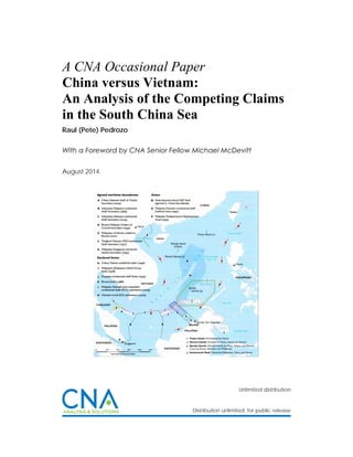
  • 2. Copyright © 2014 CNA This document contains the best opinion of the authors at the time of issue. It does not necessarily represent the opinion of the sponsor. Cover Photo: South China Sea Claims and Agreements. Source: U.S. Department of Defense’s Annual Report on China to Congress, 2012. Distribution Distribution unlimited. Specific authority contracting number: E13PC00009. Copyright © 2014 CNA This work was created in the performance of Contract Number 2013-9114. Any copyright in this work is subject to the Government's Unlimited Rights license as defined in FAR 52-227.14. The reproduction of this work for commercial purposes is strictly prohibited. Nongovernmental users may copy and distribute this document in any medium, either commercially or noncommercially, provided that this copyright notice is reproduced in all copies. Nongovernmental users may not use technical measures to obstruct or control the reading or further copying of the copies they make or distribute. Nongovernmental users may not accept compensation of any manner in exchange for copies. All other rights reserved. This project was made possible by a generous grant from the Smith Richardson Foundation Approved by: August 2014 Ken E. Gause, Director International Affairs Group Center for Strategic Studies
  • 3. FOREWORD This legal analysis was commissioned as part of a project entitled, “U.S. policy options in  the South China Sea.” The objective in asking experienced U.S international lawyers, such as  Captain Raul “Pete” Pedrozo, USN, Judge Advocate Corps (ret.),1  the author of this analysis, is to  provide  U.S.  policy  makers  access  to  work  that  tests  the  various  legal  arguments  that  the  respective  claimants  make  in  support  of  their  claims,  and  weigh  them  against  the  relatively  limited body of international case law associated with maritime disputes of this sort.    Importantly, this analysis of Vietnamese claims versus Chinese claims to the Paracel and  Spratly archipelagoes was not undertaken as a prelude to a recommendation that the United  States  depart  from  its  long  held  position  of  not  taking  a  position  on  competing  sovereignty  claims in the South China Sea. That is not the intent, nor is it one of the recommendations of  the project.    Captain Pedrozo’s findings are summarized below:    Based  on  the  arguments  and  evidence  submitted  by  the  claimants  and  general  principles  of  international  law  related  to  the acquisition  of  territory,  it  would  appear  that Vietnam clearly has a superior claim to the South China Sea islands.    Vietnam’s title to the Paracels is well founded in both history and law. Beginning in the  early 18th  century, Vietnam demonstrated a clear intent to assert sovereignty over the  islands through the establishment of a government‐sponsored company to exploit and  manage the resources of the archipelago. That intent was confirmed by the annexation  of the islands and symbolic acts of sovereignty in the early 19th  century, followed by  peaceful, effective, and continuous administration of the islands by successive Nguyen  dynasties until the advent of the French colonial period. France continued to effectively  administer the islands on behalf of Vietnam and physically took possession and occupied  the Paracels in the 1930s. Thereafter, France continued to assert its sovereignty over  the  Paracels  until  its  departure  from  Indochina  in  1956.  Following  the  French  withdrawal,  South  Vietnam  (and  subsequently  a  united  Vietnam)  effectively  administered the islands and never ceased to assert Vietnamese sovereignty over the  archipelago, even after China illegally occupied a portion of the islands in 1956 and the  entire archipelago in 1974.    On the other hand, the first demonstration of Chinese sovereignty over the Paracels did  not occur until 1909, two centuries after Vietnam had legally and effectively established                                                               1  Captain Raul (Pete) Pedrozo, U.S. Navy (Ret.). Former Professor of International Law, U.S. Naval War College; Staff  Judge Advocate, U.S. Pacific Command; and Special Assistant to the Under Secretary of Defense for Policy. The  views expressed in this paper do not reflect the views of the U.S. government, the U.S. Department of Defense, or  the U.S. Navy.   
  • 4. ii    its title to the islands. Moreover, China’s illegal occupation of Woody Island in 1956, and  its occupation of the entire archipelago by force in 1974, clearly violate Article 2(4) of  the UN Charter and accordingly do not confer a clear legal title to the Paracels.    With regard to the Spratlys, France annexed the islands as terra nullius in the 1930s—at  the  time,  occupation  by  force  was  a  valid  method  of  acquiring  sovereignty  over  territory. Great Britain, which had controlled some of the Spratly Islands in the 1800s,  abandoned  its  claims  following  the  French  annexation  and  effective  occupation,  so  French  title  to  the  Spratlys  was  legally  and  soundly  established.  France’s  title  to  the  archipelago  was  ceded  to  South  Vietnam  in  the  1950s  and  the  South  Vietnamese  government (and subsequently a united Vietnam) effectively and peacefully controlled  the  islands  until  ROC  forces  illegally  occupied  Itu  Aba  Island  in  1956  and  PRC  forces  illegally occupied a number of islets in the archipelago in 1988.      The ROC’s occupation of Itu Aba Island in 1946 and 1956, and the PRC’s invasion of the  Spratlys in 1988, violate Article 2(4) of the UN Charter and cannot confer clear title to  the  Spratlys  to  either  Taiwan  or  China.  The  fact  that  China  may  have  challenged  Vietnamese  sovereignty  over  the  Spratlys  between  1951  and  1988,  rights  that  were  legally ceded by France to Vietnam, does not in and of itself create a clear title for China.     The  Pedrozo  analysis  differs  in  part  from  two  other  third  party  analyses,  one  by  Dr.  Marwyn S. Samuels, an American scholar, who wrote the first detailed study on the origins of  the  disputes  among  China,  Vietnam  and  in  the  Philippines.  A  meticulous  scholar  who  used  Vietnam and Chinese sources, his Contest for the South China, holds up very well some 40 years  later.2  Samuels concluded that China had the better claim to the Paracels, but that China’s claim  to the Spratly’s was “highly questionable.”3  His judgments were partially echoed by Australian  scholar  Dr.  Greg  Austin,  who  has  legal  training.  In  his  well‐regarded  China’s  Ocean  Frontier,  published in 1998.4  Austin found that China had “superior rights in the Paracels,” but the legal  complexity of the disputed Spratly claims meant that, “PRC claims to the entire Spratly group  are at least equal to any other.”5     Pedrozo’s  findings  are  supported  by  Professor  Monique  Chemillier‐Gendreau  in  her  work, Sovereignty over the Paracel and Spratly Islands. Professor Chemllier‐Gendreau is a legal  scholar and Professor Emeritus at Paris University‐Diderot.6     In reviewing all of these works, it is clear to me that in the unlikely event these claims  are ever taken to the International Court of Justice to resolve the disputes over sovereignty the                                                               2  Marwyn S. Samuels, Contest for the South China Sea, Methuen New York, 1982.  3  Ibid, p. 68.  4  Greg Austin, China’s Ocean Frontier: International Law, Military Force, and National Development, Allen and  Unwin, NSW, Australia, 1998.   5  Ibid, p. 161.  6  Monique Chemilleir‐Gendreau, Sovereignty over the Paracel and Spratly Islands, Springer (English translation),  2000.  
  • 5. iii    process will be long and difficult. None of the claimants has what might be called an “open and  shut” legal case—although the consensus among scholars seems to be that China’s claims in the  Spratlys are weaker than those to the Paracels.    The reality on the ground is that China has occupied the entire Paracel group for 40  years, and short of military action by Vietnam to recapture the archipelago, will never leave.  The  issue  is  more  complicated  in  the  Spratlys.  China,  Taiwan,  Vietnam,  Malaysia  and  the  Philippines all permanently occupy features in the Spratly group. Resolution of the dispute is  likely in only four ways: judicial arbitration that all parties agree to undertake; all parties agree  to  freeze  in  place  while  tabling  the  issue  of  ultimate  sovereignty  in  favor  of  a  cooperative  regime for resource exploitation and management; individual claimants reach an understanding  with China ceding sovereignty claims in return for economic preference; or the use of force by  the most powerful to expel rival claimants.                                                   Michael McDevitt                                              Senior Fellow and Project Director                       
  • 7. v    Table of Contents  I. INTRODUCTION ........................................................................................................................................ 1   II. ACQUISITION OF TERRITORY ................................................................................................................... 3   III. CHINA .................................................................................................................................................... 5   A. Chinese Claims ............................................................................................................................. 5  1. Historical Evidence ............................................................................................................................ 5  2. Economic Development .................................................................................................................... 8  3. Effective Administration ................................................................................................................. 12     a. Naval Patrols ................................................................................................................................ 12     b. Administrative Control ................................................................................................................. 14     c. Persistent Objector ....................................................................................................................... 19     d. Reaffirming Sovereignty ............................................................................................................... 23     e. Military Intervention ..................................................................................................................... 24  4. International Recognition ............................................................................................................... 25     a. The Sino‐French Treaty of 1887 .................................................................................................... 25     b. French Recognition before World War II ...................................................................................... 26     c. French Recognition after World War II ......................................................................................... 28     d. Japanese Recognition ................................................................................................................... 29     e. World War II Documents .............................................................................................................. 30     f. Post‐War Occupation .................................................................................................................... 30     g. San Francisco Peace Conference .................................................................................................. 31     h. International Civil Aviation Organization (ICAO) Conference ....................................................... 33     i. North Vietnamese Indifference...................................................................................................... 34     j. Other Supporting Publications....................................................................................................... 35  IV. VIETNAM ............................................................................................................................................. 37   A. Vietnam Claims .......................................................................................................................... 37  1. Historical Evidence .......................................................................................................................... 37  2. Economic Development .................................................................................................................. 40  3. Effective Administration ................................................................................................................. 43     a. French Colonial Rule ..................................................................................................................... 45     b. Return to South Vietnamese Control ............................................................................................ 53     c. Post‐unification Administration .................................................................................................... 58  4. Right of Cession ............................................................................................................................... 61  5. International Recognition ............................................................................................................... 61  V. CONCLUDING ANALYSIS ........................................................................................................................ 64   A. Evaluation of China’s Position .................................................................................................... 64  1. Discovery versus Awareness ........................................................................................................... 64 
  • 8. vi    2. Probative Value of Historic Maps.................................................................................................... 67  3. Inchoate Title and Effective Occupation ......................................................................................... 69     a. Remote and Uninhabited Territories ............................................................................................ 76     b. Suzerain and Vassal ...................................................................................................................... 79  4. Persistent Objector ......................................................................................................................... 80  5. International Recognition ............................................................................................................... 85     a. The Sino‐French Treaty of 1887 .................................................................................................... 85     b. French Recognition before World War II ...................................................................................... 87     c. French Recognition after World War II ......................................................................................... 93     d. Japanese Recognition ................................................................................................................... 94     e. World War II Documents .............................................................................................................. 96     f. Post‐War Occupation .................................................................................................................... 98     g. San Francisco Peace Conference .................................................................................................. 99     h. International Civil Aviation Organization (ICAO) Conference ..................................................... 104     i. North Vietnamese Indifference.................................................................................................... 104     j. Other Supporting Publications..................................................................................................... 108  B. Evaluating Vietnam’s Position .................................................................................................. 108  1. Historical Evidence and Maps ....................................................................................................... 109  2. Economic Development ................................................................................................................ 111  3. Effective Occupation and Administration ..................................................................................... 112     a. Effective Administration During the French Colonial Period ...................................................... 113     b. Effective Administration by South Vietnam ............................................................................... 119     c. Post‐unification Administration .................................................................................................. 122  4. Right of Cession ............................................................................................................................. 124  5. International Recognition ............................................................................................................. 128  C. Final Thoughts .......................................................................................................................... 130   
  • 9. 1    I. INTRODUCTION* The  South  China  Sea  stretches  from  Singapore  and  the  Strait  of  Malacca  in  the  southwest, to the Strait of Taiwan in the northeast. It is bounded on the east by the Philippine  Islands, on the south by Borneo, on the west by Vietnam, and on the north by mainland China.  The area includes several hundred small islands, rocks, atolls, islets, cays, shoals, sandbars, and  reefs. Many are underwater at high tide, while others are permanently submerged even at low  tide. These features, most of which are uninhabitable, are situated in three island chains (the  Spratly, Paracel, and Pratas Islands), the Macclesfield Bank, and Scarborough Shoal.   The South China Sea links the Pacific and Indian oceans and is home to some of the  world’s busiest and most strategically important sea lines of communication. More than half of  the  world’s  oil  tanker  traffic  and  over  half  of  the  world’s  merchant  fleet  (by  tonnage)  sail  through these waters every year. In addition, the South China Sea is rich in natural resources,  including  abundant  fisheries  and  potentially  large  oil  and  natural  gas  deposits.1   Sovereignty  over the various land masses—and the resulting maritime zones that would flow from these  features—would  place  many  of  these  resources  under  the  exclusive  control  of  one  nation.  Competing claims to these resources could result in conflict, which, in turn, could affect the free  flow of commerce through the region. Peaceful resolution of the dispute is, therefore, critical to  maintaining regional peace and stability, as well as a vibrant world economy.  Pratas Island2  and the Macclesfield Bank3  are claimed by Taiwan and China. No nation  has challenged China’s or Taiwan’s claim to Pratas Island. However, Macclesfield Bank and its  surrounding shoals are located beyond the territorial sea of any nation and are permanently  submerged, even at low tide. Accordingly, these features may not be claimed by any nation.  Although the International Court of Justice (ICJ) has stated that international law “is silent on  the question whether low‐tide elevations can be considered to be ‘territory,’” and that there is  no  “customary  rule  which  unequivocally  permits  or  excludes  appropriation  of  low‐tide  elevations,” the few rules in the law of the sea that govern low‐tide elevations “do not justify a  general  assumption  that  low‐tide  elevations  are  territory  in  the  same  sense  as  islands.”4   Moreover, the Court noted that “it has never been disputed that islands constitute terra firma,  and are subject to the rules and principles of territorial acquisition; [however,] the difference in                                                               *  This analysis is authored by Captain Raul (Pete) Pedrozo, U.S. Navy (Ret.). Former Professor of International Law,  U.S. Naval War College, Staff Judge Advocate, U.S. Pacific Command, and Special Assistant to the Under Secretary  of Defense for Policy. The views expressed in this paper do not reflect the views of the U.S. government, the U.S.  Department of Defense, or the U.S. Navy.  1  South China Sea Report, U.S. ENERGY INFORMATION ADMINISTRATION, last updated Feb. 7, 2013.  2  Pratas Island (20°42'N., 116°43'E.) lies 160 miles southeast of Hong Kong and is composed of sand covered with  scrubby brush. The island is governed by Taiwan and is home to a weather station located near the center of the  east part of the island. NATIONAL GEOSPATIAL‐INTELLIGENCE AGENCY PUBLICATION 161, Sailing Directions (Enroute), South  China Sea and the Gulf of Thailand, Thirteenth Edition (2011) [hereinafter PUB. 161].  3  Macclesfield Bank (15°45'N., 114°20'E.) is a submerged atoll about 75 miles long on its northeast‐southwest axis  and about half that wide at its broadest part. Pub. 161.  4  Maritime Delimitation and Territorial Questions between Qatar and Bahrain, Merits, Judgment, I.C.J. Reports  2001, p. 40, at pp. 101‐103; accord Sovereignty over Pedra Branca/Pulau Batu Puteh Middle Rocks and South Ledge  (Malaysia/Singapore), Judgment, I.C.J. Reports 2008, p. 12, at pp. 99‐101. 
  • 10. 2    effects which the law of the sea attributes to islands and low‐tide elevations is considerable.”5   Accordingly, the Court concluded that “it is thus not established that in the absence of other  rules  and  legal  principles,  low‐tide  elevations  can,  from  the  viewpoint  of  the  acquisition  of  sovereignty, be fully assimilated with islands or other land territory.”6  A similar, albeit more  persuasive, argument could be made with regard to completely submerged features, such as  Macclesfield Bank.7  Nonetheless, because China’s claim to Macclesfield Bank is not contested  by Vietnam, it is not discussed in detail in this paper.  Scarborough Shoal8  is claimed by China, Taiwan, and the Philippines. The total area of  the shoal, including its inner lagoon, is 150 square kilometers.9  The reef is situated about 170  nautical  miles  (nm)  east  of  Macclesfield  Bank,  115  nm  off  the  Philippine  island  of  Luzon  (Zambales Province), and 472 nm from the Chinese coast.10  China argues that it discovered the  shoal and has exercised effective control over it for hundreds of years. The Philippines claims  that it has effectively occupied the shoal since 1946.11  Because the dispute over the shoal does  not involve Vietnam, it is not discussed in detail in this paper.   The Paracel Islands12  are spread over a sea area of 15,000 to 16,000 square kilometers  and are claimed by Vietnam, Taiwan, and China, but have been occupied by China since 1974.  Most of the features in the South China Sea are in the Spratly Island13  chain and are spread over  160,000 to 180,000 square kilometers of ocean area. The Spratlys are claimed in their entirety  by China, Taiwan, and Vietnam, and partially by the Philippines, Malaysia, and Brunei. All of the                                                               5  Id.  6  Id.  7  Robert Beckman, Scarborough Shoal: Flashpoint for Confrontation or Opportunity for Cooperation, RSIS  COMMENTARIES, No. 072/2012, Apr. 24, 2012 (“…under international law, Macclesfield Bank may not be capable of  being subject to a claim of sovereignty because it is completely submerged.”) [hereinafter RSIS COMM. No.  072/2012].  8  Scarborough Reef (Scarborough Shoal) (15°08'N., 117°45'E.) consists of a narrow belt of barely submerged reef  enclosing a lagoon. On the belt are scattered rocks, with over 20 rocks standing 1.5 to 2.5 meters high. Fishing  vessels from China and the Philippines frequent the reef to exploit the abundant living resources around the shoal.  The ruins of an iron tower stand close to the above channel opening. PUB. 161.  9  Zou Keyuan, Scarborough Reef: A New Flashpoint in Sino‐Philippine Relations?, INTERNATIONAL BOUNDARIES RESEARCH  UNIT BOUNDARY AND SECURITY BULLETIN 71, Summer 1999, at p. 71 [hereinafter IBRU BULL. 71].  10  Id.  11  The Philippines’ claim is based on a number of activities, including building and operating of a lighthouse on the  shoal in 1965, conducting a number of hydrographic surveys and marine scientific research in the waters around  the shoal, using the shoal as an impact range for military exercises and enforcing its laws on smuggling and illegal  fishing. RSIS COMM. No. 072/2012; see also IBRU BULL. 71, at p. 74.  12  The Paracel Islands (16°40'N., 112°20'E.) are made up of the Amphitrite Group, the Crescent Group, and several  off‐lying islands and coral reefs, some of which are covered with trees or vegetation. The Amphitrite Group  (16°53'N., 112°17'E.) is the northeasternmost cluster of islands, reefs, and shoals in the Paracels. The Crescent  Group lies 45 miles southwest of the Amphitrite Group and consists of several low sand islets and numerous reefs.  The principal islands are covered with thick vegetation. PUB. 161.  13  The Spratly Islands lie in the southeast part of the South China Sea along an oblong area about 52,000 square  miles in extent, northwest of the strategic Palawan Passage. The area is dotted with sunken reefs and coral atolls.  The major axis of the area bears about 045°‐225° for a distance of 340 miles with a maximum breadth along its  minor axis of 175 miles. PUB. 161. 
  • 11. 3    claimants,  except  Brunei,  have  established  military  outposts  on  a  number  of  features.14   Vietnam occupies the most features, followed by the Philippines, China, Malaysia, and Taiwan.   The Paracel and Spratly Islands are situated beyond the geological continental shelf of  any of the claimant states. Waters around the Paracels can reach a depth of over 1,000 meters  (3,280  feet),  while  the  Spratlys  are  separated  from  any  mainland  or  major  island  by  ocean  trenches over 3,000 meters (9,842 feet) deep. Consequently, none of the claimant states can  claim  sovereignty  over  the  islands  “on  the  grounds  that  they  belong,  in  geomorphological  terms, to the continental shelf of any particular country.”15     This paper will only examine the claims of China/Taiwan and Vietnam with regard to the  Paracel and Spratly Islands, as all of the activities of the other claimants occurred well past the  critical date and can therefore not be used as a basis to claim sovereignty over any of the South  China Sea islands. That is not to say that Malaysia, Brunei, or the Philippines may not have valid  claims  to  some  of  the  submerged  features  situated  on  their  respective  continental  shelves  under the United Nations Convention on the Law of the Sea (UNCLOS); rather, it means that an  analysis of those potential claims is beyond the scope of this paper. The Philippines may also  have a valid claim to Scarborough Shoal, which is not considered part of the Spratly Islands.16   II. ACQUISITION OF TERRITORY In general, territorial sovereignty can be acquired in one of five ways: accretion, cession,  conquest, occupation, and prescription. Accretion involves the expansion of existing territory  under  the  sovereignty  of  a  state  through  geographical  or  geological  process  (e.g.,  volcanic  activity). Cession occurs when one state transfers its territory to another state pursuant to a  treaty. However, “the transferee cannot receive any greater rights than those possessed by the  transferor.”17   Conquest—the  acquisition  of  territory  by  force—was  historically  considered  a  lawful mode of acquiring sovereignty, but has been illegal since October 1945 following the  entry  into  force  of  the  United  Nations  Charter  (see  Article  2(4)).18   Prescription  involves  the  occupation of another state’s territory over a long period of time. In order for prescription to  apply, the occupying state must show that its display of state authority (à titre de souverain)                                                               14  The South China Sea Online Resource, available at www.southchinasea.org/; see also Michael Bennett, The  People’s Republic of China and the Use of International Law in the Spratly Islands Dispute, 28 STAN. J. INT’L L. 425, at  pp. 439‐440 (1997).  15  Monique Chemillier‐Gendreau, Sovereignty over the Paracel and Spratly Islands (Brill/Martinus Nijhoff  Publishers, 2000), at p. 16 and Annex 18 (Note dated 8 March 1928 from Mr Bourgouin).  16  PUB. 161.  17  D. P O’Connell, Territory, INTERNATIONAL LAW 437, Vol. 1 (2nd  ed.), Stevens & Sons, 1970 [hereinafter O’CONNELL  INTERNATIONAL LAW (2nd  ed.)]; see also James Crawford, Acquisition and Transfer of Territorial Sovereignty, BROWNLIE’S  PRINCIPLES OF PUBLIC INTERNATIONAL LAW 217 (8th  ed.), Oxford University Press, 2012 [hereinafter BROWNLIE (8th  ed.)].  18  Charter of the United Nations, June 26, 1945, Article 2(4) provides that “all members shall refrain in their  international relations from the threat or use of force against the territorial integrity or political independence of  any state….” Accord M. Chemillier‐Gendreau, note 15 supra. (“Wars of conquest, as a source of new sovereignty  over a territory, are now prohibited. Conquest by force entails a situation of military occupation which is always  illegal and which, failing an agreement concluded between the States concerned, cannot be transformed into law,  even with the passage of time.”). 
  • 12. 4    over the other state’s territory was public, peaceful, and uninterrupted for a long period of  time.19    Finally, a state may acquire sovereignty over territory that is not under the control of  any  other  state  (terra nullius)  to  the  extent  that  the  state  effectively  occupies  the  territory.  Discovery alone, however, without subsequent acts of effective occupation, does not confer  title to territory—“an inchoate title of discovery must be completed within a reasonable period  by effective occupation of the region claimed to be discovered.”20  Moreover, an inchoate title  will not “…prevail over the continuous and peaceful display of authority by another State; for  such display may prevail even over a prior, definite title put forward by another State.”21    A claim to sovereignty based on effective occupation “involves two elements each of  which  must  be  shown  to  exist:  the  intention  and  will  to  act  as  sovereign,  and  some  actual  exercise or display of such authority.”22  As discussed in the Clipperton Island case, besides the  animus  occupandi,  effective  occupation  requires  the  actual,  and  not  the  nominal,  taking  of  possession. “This taking of possession consists in acts, or series of acts, by which the occupying  state reduces to its possession the territory in question and takes steps to exercise exclusive  authority there.”23    The  degree  of  actual  administration  (effectivités)  that  must  be  established  by  the  occupying  state,  however,  may  vary,  particularly  in  cases  of  remote  and  uninhabited  areas.  Under such circumstances, tribunals have recognized that “sovereignty cannot be exercised in  fact  at  every  moment  on  every  point  of  a  territory”  and  that  “[t]he  intermittence  and  discontinuity  compatible  with  the  maintenance  of  the  right  necessarily  differ  according  as  inhabited  or  uninhabited  regions  are  involved….”24   Accordingly,  some  tribunals  have  “been  satisfied with very little in the way of the actual exercise of sovereign rights, provided that the  other  State  could  not  make  out  a  superior  claim…particularly…in  the  case  of  claims  to  sovereignty  over  areas  in  thinly  populated  or  unsettled  countries.”25   This  exception  to  the  general rule that there must be an actual and continuous display of authority by the occupying  state is explained in detail in the Clipperton Island case.26                                                                    19  O’CONNELL INTERNATIONAL LAW (2nd  ed.), at p. 423; see also BROWNLIE (8th  ed.), at p. 216.  20  Island of Palmas Case (Netherlands/U.S.A.), U.N. Rep., Vol. II, p. 829 (1928), at p. 846.  21  Id.  22  Legal Status of Eastern Greenland Case (Denmark v. Norway), P.C.I.J., Series A/B, No. 53 (1933), at p. 45.  23  Clipperton Island Arbitration (Mexico v. France), 2 R.I.A.A. 1105 (1931), at p. 393. [The cited pages are from the  English translation at 26 Am. J. Int’l L. 390, at 393‐394 (1932).]  24  Island of Palmas Case (Netherlands/U.S.A.), U.N. Rep., Vol. II, p. 829 (1928), p. 831, at p. 840.  25  Legal Status of Eastern Greenland Case (Denmark v. Norway), P.C.I.J., Series A/B, No. 53 (1933), at p. 46. See also  Western Sahara Advisory Opinion, I.C.J. Reports 1975, p. 12, at p. 43.  26  Clipperton Island Arbitration (Mexico v. France), 2 R.I.A.A. 1105 (1931), at pp. 393‐394. [The cited pages are from  the English translation at 26 Am. J. Int’l L. 390, at 393‐394 (1932).] (“It is beyond doubt that…the actual…taking of  possession is a necessary condition of occupation. …Strictly speaking, and in ordinary cases, that only takes place  when the state establishes in the territory itself an organization capable of making its laws respected. …There may  also be cases where it is unnecessary to have recourse to this method. Thus, if a territory, by virtue of the fact that  it was completely uninhabited, is, from the first moment when the occupying state makes its appearance there, at  the absolute and undisputed disposition of that state, from that moment the taking of possession must be  considered as accomplished, and the occupation is thereby completed.”) 
  • 13. 5    III. CHINA A. Chinese Claims China’s  position  regarding  its  sovereignty  claims  to  the  Paracel  (Xisha)  and  Spratly  (Nansha) Islands was most recently published in June 2000 by the Ministry of Foreign Affairs  (MFA) of the People’s Republic of China (PRC) in a document entitled The Issue of South China  Sea.27  In short, China’s claim of indisputable sovereignty over the Paracel and Spratly Islands  and their adjacent waters is based on several factors, including historical evidence, economic  development, effective administration, and international recognition.28    1. Historical Evidence According to the MFA, China was the first nation to discover and name the South China  Sea islands. References to the islands appear in a number of books dating as far back as the Han  Dynasty (206 BC‐220 AD). Yang Fu “described the geographic features of the South China Sea  Islands…” in his book, Yiwu Zhi (Records of Rarities).29  A famous Chinese navigator of the East  Wu  State  of  the  Three  Kingdoms  Period  (220‐280)—General  Kang  Tai—also  mentions  the  islands in his book entitled Funan Zhuan (Journeys to and from Phnom). The general, along with  Zhu  Ying,  had  been  dispatched  by  Emperor  Huangwu  on  a  diplomatic  mission  to  Funan  (present‐day Cambodia) via the South China Sea to meet with envoys from a number of states,  including  the  State  of  Tianzhu  (present‐day  India).30   Similarly,  hundreds  of  books  published  during  the  Jin  (265‐410),  Tang  (618‐907),  Song  (960‐1279),  Yuan  (1271‐1368),  Ming  (1368‐ 1644), and Qing (1644‐1911) Dynasties refer to the South China Sea islands. These include the  Dao  Yi  Zhi  Lue  (Abridged  Records  of  Islands  and  Barbarians)  written  by  Wang  Dayuan,  a  prominent Chinese navigator of the Yuan Dynasty who made numerous voyages to the South  China Sea, and the Nanzhou Yuou Zhi (Records of Rarities in Southern Boundary) by Wan Zhen,  which documents the encounters of Chinese sailors of the Han era (206 BC‐220 AD) with the                                                               27  Ministry of Foreign Affairs of the People’s Republic of China, The Issue of South China Sea (June 2000),  [hereinafter MFA, The Issue of South China Sea], available at http://www.fmprc.gov.cn/eng/5767.html;  http://www.fmprc.gov.cn/eng/5765.html; http://www.fmprc.gov.cn/eng/5773.html;  http://www.fmprc.gov.cn/eng/5747.html; and http://www.fmprc.gov.cn/eng/5766.html. A previous version— China’s Indisputable Sovereignty over the Xisha Islands and Nansha Islands—was published by the MFA in January  1980.  28  MFA, The Issue of South China Sea; see also Su Hao, China’s Positions and Interests in the South China Sea: A  Rational Choices in its Cooperative Policies, CENTER FOR STRATEGIC & INTERNATIONAL STUDIES, SOUTH ASIA PROGRAM, Sept.  12, 2011; Jianming Shen, International Law Rules and Historical Evidence Supporting China’s Title to the South  China Sea Islands, 21 HASTINGS INT’L & COMP. L. REV. 1‐75 (1997‐1998) [hereinafter Shen I]; and Jianming Shen, China’s  Sovereignty over the South China Sea Islands: A Historical Perspective, CHINESE JIL (2002), pp. 94‐157 [hereinafter  Shen II].  29  Shen I, at p. 18. See also Brian K. Murphy, Dangerous Ground: The Spratly Islands and International Law, 1 OCEAN  & COASTAL L.J. 187 (1994‐1995), at p. 200; Dr. Barry Hart Dubner, The Spratly “Rocks” Dispute—A “Rockapelago”  Defies Norms of International Law, 9 TEMP. INT’L & COMP. L.J. 291 (1995), at p. 309; M. Bennett, note 14 supra, at p.  434.  30  Shen I, at p. 19. 
  • 14. 6    South China Sea islands on their return trip home from the Malay Peninsula.31  A book published  during the South Song Dynasty (1127‐1279)—Qiong Guan Zhi (Records of the Qiong Prefecture  and its Jurisdiction)—likewise reflects that the Spratlys and Paracels were under the jurisdiction  of the Qiong Prefecture (today’s Hainan Province).32   According to the MFA, Emperor Zhenyuan of the Tang Dynasty (785‐805) included the  South China Sea islands in the administrative maps of the Empire. Reference to the islands can  also be found in a number of maps, including the Hunyi Jiangli Lidai Guodu zhi Tu (Consolidated  Map of Territories and Geography and Capitals of Past Dynasties), published during the Ming  Dynasty, and the Geng Lu Bu (Road Map) of the Qing Dynasty.33    Chinese scholars likewise attribute great importance to Chinese efforts during the Song,  Yuan, Ming, and Qing Dynasties to include the South China Sea islands in the country’s official  maps  as  a  demonstration  of  sovereignty.  For  example,  Zhu  Fan  Tu  (Maps  of  the  Various  Barbarian  Peoples)  of  the  North  Song  Dynasty  is  a  collection  “of  ancient  Chinese  maps  that  referred  to  the  South  China  Sea  Islands  as  being  subject  to  the  Chinese  rulers.”34   More  specifically, the Zhu Fan Tu (Maps and Charts of the Various Barbarian Peoples, the North Song  Dynasties) referred to the Spratlys and the sea area west of the Paracels as the outer limits of  China’s maritime boundary.35  Thus, both the Paracels and Spratlys “were within the boundary  of the Song Empire.”36    According to Chinese scholars, maps published in the Yuan Dynasty included the Paracel  and Spratly Islands as Chinese territory.37  Similarly, during the Ming Dynasty, “official Chinese  maps  [such  as  the  Hunyijiangli  Hdai  Guodu  zhi  Tu  (Consolidated  Map  of  Territories  and  Geography and  Capitals  of  Past  Dynasties (1402))]  continued  to  indicate  China's sovereignty  over the South China Sea Islands.”38  Ming‐era maps were used by Admiral Zheng He during his  Seven  Voyages.  Official  records  of  the  Ming  Dynasty,  such  as  Qiong  Guan  Gu  Zhi  (Ancient  Records on the Jurisdiction of Qiongzhou Fu), also refer to Chinese jurisdiction over the Spratlys  and Paracels.39  In Zhengde Qiong Tai Zhi (Records of Qiong[zhou] and Tai[wan] During the Reign                                                               31  MFA, The Issue of South China Sea; see also Shen II, at pp. 111 and 113‐116; Shen I, at pp. 19, 27‐28. Historical  evidence of the earliest Chinese presence in the Paracels can also be found in the Chronicles of the Sung Dynasty,  “which states that the last Sung Emperor, pursued by a Yuan (Mongol) Dynasty general, fled to the Paracels in an  attempt to reach Indo‐China.” Tao Cheng, The Dispute Over the South China Sea Islands, 10 TEX. INT’L L. J. 265  (1975), at p. 273.  32  References to the Spratlys and Paracels can also be found in other Song‐related books, such as Song Hui Yao Ji  Gao (Selected Manuscripts of the Digests of the Song Dynasties), Song Shi (The History of the Song Dynasties) and  Zhu Fan Tu (Maps and Charts of the Various Barbarian Peoples, the North Song Dynasty). Shen II, at pp. 132‐133;  see also Shen I, at pp. 23‐24.  33  MFA, The Issue of South China Sea; see also Shen II, at p. 106.  34  Shen II, at p. 126.  35  Shen I, at p. 24.  36  Id., at p. 26.  37  Some of these maps include: Yuandai Jiangyu Tu Xu (Map of the Territory of the Yuan Dynasty Illustrated);  Shengjiao Chiang Bei Tu) of 1330 by Li Zemin, the Hunyi Jiangli Tu (Consolidated Maps of the Territory [of the Yuan  Dynasty]) of 1380, and the Yu Di Tu (The Maps of the Territory [of Yuan]) drawn and illustrated by Zhu Siben  (Yuan). Shen II, at pp. 126‐127; see also Shen I, at pp. 28‐29.  38  Shen II, at p. 127. A similar reference is contained in the Wubei Mishu Dili Fu Tu (A Geographical Map Annexed to  the Secret Manual on Defense Preparations (1637)). Shen I, at p. 30.  39  Shen II, at p. 133. 
  • 15. 7    of  Emperor  Zhengde),  Tan  Zhou  recorded  that  “the  sphere  of  jurisdiction  of  the  Qiongzhou  Prefecture included the…Xisha Islands and Nansha Islands.”40   Qing Dynasty maps, such as the Sihai Zongtu (General Maps of the Four Seas), published  in 1730 by Chen Lunjiong, continued to depict the position of the Paracels and Spratlys within  the  Qing  boundary.41   Chen  also  published  a  book  in  1730—Haikuo  Wenchien  Lu  (Notes  on  Lands  Across  the  Sea)—that  described  the  geographic  positions  of  the  Spratly  and  Paracel  Islands.42   Qing‐era  records  (e.g.,  Records  of  Wanzhou  Subprefecture,  Records  of  Qiongzhou  Prefecture and Guangdong Tong Zhi (General Records of Guangdong Province)) likewise reflect  that the South China Sea islands, including the sea areas surrounding the islands, were within  the jurisdiction of Wanzhou.43    A number of Chinese scholars place discovery and naming of the South China Sea islands  much earlier in Chinese history—as far back as the Xia Dynasty (2100‐1660 BC). A book written  during the Qin Dynasty (221‐206 BC)—Yi Zhou Shu (Scattered Books of the Zhou Dynasties)— speaks  of  “tributes  from  the  South  Sea”  being  paid  by  the  southern  barbarians  (including  present‐day  Vietnam)  to  the  rulers  of  the  Xia  Dynasty,  and  says  that  these  tributes  (turtles,  pearl‐carrying  shellfish,  hawksbill  turtles,  and  other  rarities)  continued  through  the  Shang  Dynasty (1600‐1050 BC), the Zhou Dynasties (1046‐256 BC), the Qin Dynasty (221‐206 BC) and                                                               40  Shen I, at pp. 29‐30.  41  Other Qing‐era maps cited in support of Chinese sovereignty over the South China Sea islands include:  (1) Da Qing Zhong Wai Tianxia Quan Tu (The Complete Sino‐Foreign Maps of the Great Qing) of 1709;  (2) Qing £hi Sheng Fen Tu (Individual Maps of the Provinces Directly under the Administration of the Qing  Empire) of 1724;  (3) Huang Qing Ge Zhi Sheng Fen Tu (Individual Maps of the Provinces Directly under the Administration of the  Royal Qing) of 1755;  (4) Da Qing Wan Man Titong Quan Tu (The Complete Maps of the Unified Great Qing for Ten Thousand Years)  of 1767 charted by Zhu Xiling and revised by Huang Zhengsun;  (5) Qing Hui Fu Zhou Xian Ting Zpng Tu (The Qing‐Charted General Maps of the Capital Cities, Prefectures,  Counties and Tings) of 1800 charted by Xiao Feng;  (6) Da Qing Wan Man Titong Tianxia Quan Tu (The Complete Maps of the Whole Unified Country of Great Qing  for Ten Thousand Years) of 1803 charted by Yang Senzhong;  (7) Da Qing Wan Man Titong Dili Quan Tu (The Complete Geographical Maps of the Unified Great Qing for Ten  Thousand Years) of 1810;  (8) Da Qing Titong Tianxia Quan Tu (The Complete Maps of the Whole Unified Country of Great Qing) of 1817;  (9) Gu Jin Di Tu Quan Tu (The Complete Maps of the Lands and Territories Then and Now) of 1895;  (10) Da Qing Tianxia Zhonghua Ge Sheng Fu Zhou Xian Ting Dili Quan Tu (The Complete Geographical Maps of  the Provinces, Capital Cities, Prefectures, Counties and Tings of the Whole China of the Great Qing) of 1904  charted by Wu Changfa; and   (11) Da Qing Tianxia Zhonghua Ge Sheng Fu Zhou Xian Ting Dili Quan Tu (The Complete Geographical Maps of  the Provinces, Capital Cities, Prefectures, Counties and Tings of the Whole China of the Great Qing) of 1905  charted by Wang Xingshun.  Shen II, at pp. 127‐128. A book written by Yang Bingnan in 1844—Hai Lu (Illustrations of the Sea)—records “the  oration of Xie Qinggao, a Qing official…, in which the South China Sea islands were described in four groups…” and  a sea chart (Yiban Lu (Particular Illustrations)) prepared by Zheng Guangzu during the same time period contains  the locations of the “Dongsha, Zhongsha, Xisha and Nansha Islands.” Shen I, at pp. 33‐35.  42  Shen I, at p. 32; see also Hungdah Chiu and Choon‐Ho Park, Legal Status of the Paracel and Spratly Islands, OCEAN  DEV. & INT’L L., 3:1 (1975), 1‐28, at p. 10.  43  Shen II, at pp. 133‐134; see also Shen I, at p. 30. 
  • 16. 8    the Han Dynasty (206 BC‐220 AD).44  References to the South China Sea islands also appear in  Shi Jing (The Classics of Poems), “a collection of…poems of the Spring and Autumn Period (475‐ 221 BC)…” and two sets of classics of the Spring and Autumn Period authored by Zuo Qiuming— Zuo Zhuan (Zuo’s Commentaries) and Guo Yu (Statements of the States)—both of which indicate  that the Zhou state “appeased the barbarians to make expeditions to the South China Sea….”45   Based on these early works, Chinese scholars argue that the “South China Sea Islands  were…destinations  of  Chinese  expeditions  and  targets  of  conquests  during  the  East  Zhou  Dynasty  (770‐221  BC)  …”  and  that  “such  discovery  and  conquest…naturally  led  the  Chinese  rulers and people to believe that the South China Sea Islands were part of China throughout  history, from the Xia Dynasty…to the Qing Dynasty….”46    Irrespective of whether the Spratlys and Paracels were discovered during the Xia or Han  Dynasty,  China  maintains  that  it  had  “the  earliest  recorded  contact  with  the  islands.”47   Accordingly, some Chinese and western scholars argue that discovery of the South China Sea  islands, at the very least, vested China with an inchoate title to the islands, which China could  perfect within a reasonable amount of time by taking final and decisive sovereign action over  the claimed territory.48   2. Economic Development According  to  the  MFA,  Chinese  fishermen  have  been  exploiting  the  South  China  Sea  islands since the Jin Dynasty (265‐420).49  In his article, Chronicles of Guangzhou, Fei Yuan makes  reference  to  fishing  and  collection  of  coral  samples  by  Chinese  fishermen.50   These  activities  became  more  organized  during  the  early  days  of  the  Ming  Dynasty  (1368‐1644).  Fishermen  from Haikou, Puqian, and Qinglan Ports, as well as Wenchang County, went to the islands to  fish for sea cucumbers and other sea produce. Accounts of these fishing expeditions can be  found in the 1868 Guide to the South China Sea.51  These fishermen were guided by the Road  Map,  which  showed  the  navigational  routes  and  courses  from  Hainan  Island  and  mainland  China to the Paracel and Spratly Islands.   Chinese scholars indicate that fishing boats from Hainan Island (Wenchang and Qionghai  Counties) and Leizhou Peninsula have continued to fish the waters of the South China Sea on an  annual basis since the founding of the Republic of China in 1912. Evidence of these post‐Qing                                                               44  Shen II, at pp. 102‐103; see also Shen I, at pp. 15‐16.  45  Shen II, at pp. 103‐104; see also Shen I, at p. 17.  46  Shen II, at pp. 104‐105; see also Shen I, at pp. 15‐17.  47  M. Bennett, note 14 supra; see also B. Murphy, note 29 supra, at p. 200 (“There is little doubt that the Chinese  were the first to discover the Spratlys.”); B. Dubner, note 29 supra, at p. 309 (“Despite the disputed dates, China  may claim the earliest recorded contact [with the Spratlys].”).  48  H. Chiu and C. Park, note 42 supra, at pp. 17‐18; see also B. Murphy, note 29 supra, at p. 200.  49  According to some Chinese scholars, economic exploitation of the South China Sea began as early as the Xia  Dynasty (2100‐1600 BC). Shen II, at pp. 111 and 130. See also Tao Cheng, note 31 supra, at p. 274.  50  Shen I, at p. 20.  51  MFA, The Issue of South China Sea (“…fishermen from Hainan Island went to Zhenhe Isles and Reefs and lived on  sea cucumber and shells they got there. The footmarks of fishermen could be found in every side of the Nansha  Islands and some of the fishermen would even live there for a long period of time. Every year, there were small  boats departing from Hainan Island for the Nansha Islands to exchange rice and other daily necessities for sea  cucumber and shells from the fishermen there. The ships used to leave Hainan Island in December or January  every year and return when the southwesterly monsoon started.”). See also Shen II, at pp. 130‐131. 
  • 17. 9    Dynasty activities can be found in a number of Chinese and foreign sources, including a 1918  book written by Okura Unosuke entitled Stormy Islands (about a Japanese expedition to Beizi  Island) and A Survey of the New South Islands (a Japanese publication that indicates Chinese  fishermen resided on the islands and grew coconuts, papaya, sweet potato and vegetables).  Records from a 1933 investigative trip to the Paracel Islands by Miyoshi and Matuo of Japan  also discuss the presence of Chinese fishermen on Beizi (North) and Nanzi (South) Islands.52   Similarly,  an  account  written  in  1933  by  Chinese  historian  and  geographer  Ling  Chunsheng  makes reference to the presence of Chinese fishermen on Amboyna Cay, Spratly Island, Itu Aba  Island, Loaita Island, Thitu Island, Northeast Cay, Southwest Cay, Namyit Island, and West York  Island in the Spratly archipelago.53   Although the MFA acknowledges that early Chinese activities on the Spratlys were not  state  sponsored,  it  indicates  that  subsequent  fishing  and  other  productive  activities  were  organized with the approval and support of the Chinese government. In addition, fishermen  were  required  to  pay  taxes  and  fees  to  the  Chinese  government  in  order  to  exploit  the  resources of the Spratlys.   Chinese  scholars  additionally  emphasize  that  in  1910  the  Qing  government  invited  Chinese merchants to submit contracts to administer the development and exploitation of the  South  China  Sea  Islands,  indicating  that  the  government  would  provide  protection  to  the  merchants  and  maintain  order  “to  strengthen  [China’s]  territorial  sovereignty  and…protect  [Chinese] titles and interests” in the two island groups.54  This practice was expanded by the  Republic  of  China  (1912‐1949),  although  Chinese  scholars  acknowledge  that  most  of  the  development and exploitation activities occurred in the Paracels, not the Spratlys.55  Following                                                               52  MFA, The Issue of South China Sea; see also Shen II, at p. 131.  53  Shen II, at pp. 141‐142.  54  Id., at p. 135; see also Shen I, at p. 36.  55  Examples of development and exploitation activities in the Paracels include:  ‐ In 1917, a Chinese businessman of the Hai Li Company, He Cheng'en, applied to the Office of the  Governor of Guangdong Province for permission to mine phosphorus ore.  ‐ In 1919, a Chinese businessman, Deng Shiying, applied to develop selected islands in the Paracels for  planting and farming.  ‐ In 1921, the Ministry of Internal Affairs of the Republic of China approved the application of a  businessman from Guangdong, He Ruinian (Ho Shui‐nien), to engage in fishing, reclamation and  cultivation, as well as to develop and exploit minerals. The license was revoked when the Chinese  government discovered that Mr. He had assigned his license to a Japanese company—the Nanxing Shiye  Company.  ‐ Between 1929 and 1931, the Guangdong Provincial government granted licenses to Chinese businessmen,  including Song Xiquan and Yan Jingzhi, to exploit guano.  ‐ In 1932, the Chinese government contracted with the China National Fertilizer Company (Zhonghua  Guochan Feitian Gongsi) to develop and exploit natural resources in the Paracels.  ‐ In 1932, the Industrial Testing Institute of the Department of Construction of the Guangdong provincial  government began mining guano on the Paracel Islands.  ‐ In 1933, the Department of Construction of the Guangdong provincial government made preparations to  construct a Guano Fertilizer Producing Plant on the Paracels and made plans to develop all of the Paracel  Islands.  ‐ In 1947, the Committee on Natural Resources of China requested the central government to consider  entrusting the Zhongyuan Qiye Gongsi (Zhongyuan Enterprise Co.) with mining guano in the Paracel  Islands. 
  • 18. 10    the establishment of the People’s Republic of China in 1949, the new government continued to  economically exploitation the South China Sea islands.56  Again, most of these activities were  conducted in the Paracels.   The MFA and Chinese scholars assert that China has continued to assert its exclusive  resource rights in the South China Sea. For instance, in June 14, 1976, the MFA reaffirmed that  “China has maintained indisputable sovereignty over the Xisha Islands and Nansha Islands and  their surrounding sea areas, and the natural resources in these areas are China's property.”57  A  similar  statement  was  made  in  September  1979  when  the  MFA  “reiterated  that  China  has  indisputable sovereignty over the Xisha Islands and Nansha Islands and their surrounding sea  areas, and the natural resources in these areas are China's property.”58  The following year, on  July 21, 1980, the MFA issued a statement condemning an agreement between Vietnam and  the  Soviet  Union  to  jointly  explore  and  exploit  oil  and  gas  deposits  on  Vietnam’s  southern  continental shelf. The statement reiterated that “the Xisha and Nansha Islands, just like the  Dongsha  and  Zhongsha  Islands,  have  always  been  part  of  Chinese  territory;  the  natural  resources in the above areas belong to China” and that “the Soviet‐Vietnamese agreement and  the  like  are  invalid.”59   A  similar  position  was  taken  in  April  1996  after  Petro  Vietnam  and                                                                                                                                                                                                   Shen I, at pp. 38‐39, 45. See also Tao Cheng, note 31 supra, at p. 274; H. Chiu and C. Park, note 42 supra, at pp. 11‐ 12; Stein Tønnesson, An International History of the Dispute in the South China Sea, EAST ASIAN INSTITUTE WORKING  PAPER NO. 71, Mar. 16, 2001note 55, at p. 8; M. Chemillier‐Gendreau,note 15 supra, at pp. 101‐102, Annex 10 (Note  of 29 September 1932 from the Legation of the Chinese Republic in France to the Ministry of Foreign Affairs, Paris),  Annex 14 (Letter of 6 October 1921, from the official in charge of the Consulate of France in Canton to the Président  du Conseil, Minister for Foreign Affairs).  56  The following are examples of economic development of the South China Sea islands following the  establishment of the People’s Republic of China:  − From 1950 to 1952, the governments of Wenchang County, Qionghai County, Lingshui County, and others  organized fishermen of Hainan to exploit the waters surrounding the Xishas and Nanshas; this practice has  continued ever since.  − In 1953, the Aquatic Products Corporation of the Hainan Special Administrative Prefecture began to mine  and exploit guano in the Xisha Islands.  − In May and June 1955, the Hainan Special Administrative Prefecture dispatched a survey and  reconnaissance group to the Xishas to assess the natural resources on the islands.   − In April 1956, the Aquatic Products Department of Guangdong Province organized a reconnaissance team  to investigate the aquatic resources in the Xisha Islands. A central working station was established on  Yongxing Island, and branch stations were set up on other islands. More than 200 team members worked  all over the islands. The team also set up Supply and Marketing Cooperatives (small shops), medical  clinics, clubs, and power stations.  − In 1957, the Guano Corporation of the Hainan Special Administrative Prefecture mined guano and  phosphate rocks on the Yongxing Island, with more than 100 workers participating. …  − From the winter of 1959 to April 1960, the Aquatic Products Bureau of the Hainan Special Administrative  Prefecture organized 131 fishing boats and 1,752 fishermen from the coastal counties to engage in large‐ scale fishing in the waters surrounding the Xisha and Nansha Islands.   Shen I, at p. 47.  57  Id., at p. 67. On January 1, 2014, new regulations took effect that require foreign fishing vessels to obtain prior  approval from China to fish in the 2 million km2  sea area administered by Hainan Province in the South China Sea  (waters encompassed by the so‐called “nine‐dash line”). Brian Spegele, Beijing Moves to Bolster Claim in South  China Sea, THE WALL STREET JOURNAL, Jan. 9, 2014, at p. A9.  58  Shen I, at pp. 67‐68.  59  Id., at p. 68. 
  • 19. 11    Conoco  announced  that  they  had  signed  a  contract  for  joint  exploration  and  drilling  in  the  Vanguard Bank (Wan’an Tan). In that case, the MFA reasserted “that China has incontestable  sovereignty over the Nansha Islands and their adjacent waters.”60    Continued foreign investment in the region in the 21st  century has prompted China to  reiterate its opposition to any oil and gas exploitation in the South China Sea without Beijing’s  permission. On September 22, 2011, the Chinese Foreign Ministry condemned a deal between  India’s state‐owned Oil and Natural Gas Corporation (ONGC) Videsh Ltd. and PetroVietnam to  explore and develop oil and gas blocks in the South China Sea within Vietnam’s claimed EEZ.  The  MFA’s  statement  indicated  that  any  hydrocarbon  exploration  in  the  South  China  Sea  without Beijing’s approval was an infringement on PRC sovereignty and, therefore, illegal and  invalid.61  China reacted similarly in April 2012 to an announced deal between a Russian natural  gas producer (Gazprom) and Vietnam Oil & Gas Group to develop two gas blocks in the South  China  Sea.62   Then,  in  May  2014,  state‐owned  China  National  Offshore  Oil  Corporataion  (CNOOC) deployed its deep sea drilling rig HD‐981 to the disputed waters south of the Paracels  to conduct exploratory drilling for oil. A large number of government vessels, including seven  PLAN warships, were deployed to support the operation.63   China has additioinally used its navy and civilian maritime law enforcement agencies to  directly interfere with Vietnamese and Filipino resource exploration and exploitation activities  within their respective claimed EEZs in the South China Sea. On March 2, 2011, for example,  two China Maritime Surveillance (CMS) patrol boats (No. 71 and 75) forced the survey ship M/V  Veritas Voyager that was conducting a seismic survey for oil and gas on behalf of the Philippine  Department of Energy in the vicinity of Reed Bank (80 nm west of Palawan Island) to withdraw  from the area. Forum Energy—the UK‐based company that had been awarded the contract to  conduct seismic surveys in the Sampaguita gas field—completed the survey at the end of March  with  the  assistance  of  a  Philippine  Coast  Guard  vessel  that  was  deployed  to  deter  further  Chinese  interference  with  the  Voyager’s  work.  Following  completion  of  the  survey,  the  Philippines invited foreign investors and oil companies to bid for the right to explore for oil and  gas in 15 different blocks off the west coast of Palawan. Beijing immediately protested Manila’s  actions, alleging that two areas (Blocks 3 and 4) fall under China’s “indisputable sovereignty.”64   A similar incident occurred off the coast of Vietnam on May 26, 2011, when three CMS  patrol vessels confronted the Binh Minh 02, a survey ship being operated by Petro Vietnam  approximately 116 nm off Dai Lanh, within Vietnam’s claimed EEZ and some 600 km south of  China’s Hainan Island. The incident ended when one of the CMS patrol vessels intentionally cut  the  cable  being  towed  by  the  survey  ship.65   Two  weeks  later,  on  the  9th   of  June,  a  Chinese  fishing vessel (No. 62226) that was operating with two CMS patrol vessels intentionally rammed                                                               60  Id., at p. 71.  61  Michael Martina, China paper condemns Vietnam‐India energy cooperation, REUTERS, Sept. 22, 2011.   62  China Reaffirms Position on Oil, Gas Exploitation, CHINA DAILY, Apr. 11, 2012.  63  Ernest Bower & Gregory Poling, Critical Questions: Separating Fact from Fiction about Myanmar’s Rohingya,  CENTER FOR STRATEGIC & INTERNATIONAL STUDIES, May 7, 2014.  64  Manila Rejects New Chinese Claim To Territory Just 50 Miles Away From Philippine Province, THE WASHINGTON  POST, Nov. 14, 2011; Ian Storey, China and the Philippines: Implications of the Reed Bank Incident, China Brief,  Volume 11, Issue 8, THE JAMESTOWN FOUNDATION, May 6, 2011.   65  VN Demands China Stop Sovereignty Violations, VIETNAM PLUS, May 29, 2011.  
  • 20. 12    the  survey  cable  of  the  Viking  II.  The  Petro  Vietnam  ship  was  conducting  a  seismic  survey  approximately 60 nm off the southern coast of Vietnam, within Vietnam’s claimed EEZ and over  1,000 km from Hainan Island.66  China’s official response to the Binh Minh incident indicated  that:    China  holds  a  consistent  and  clear‐cut  position  on  the  South  China  Sea  issue.  China  opposes  Vietnam's  oil  and  gas  exploration  activities  within  the  waters  under  the  jurisdiction of China which undermine China's rights and interests as well as jurisdiction  over the South China Sea and violate the bilateral consensus on the South China Sea  issue.  Actions  taken  by  China's  competent  authorities  are  regular  maritime  law  enforcement and surveillance activities in the waters under the jurisdiction of China.67     Fifteen months later, on November 30, 2012, Chinese vessels once again took action  against  the  Vietnamese  seismic  research  vessel  Binh  Minh  02,  which  was  operating  within  Vietnam’s  claimed  EEZ  about  43  miles  southeast  of  Con  Co  Island  off  the  Vietnamese  coast  (Quang Tri Province).68  The Binh Minh 02 was conducting a seismic survey in Block 113, which is  jointly owned by Petro Vietnam and Russia’s Gazprom, when it was surrounded by a number of  Chinese  vessels.  When  the  Binh  Minh  ordered the  Chinese  ships  to  depart  the  area,  two  of  them cut the survey ship’s exploration cable.69   3. Effective Administration The MFA claims that China has exercised sovereignty and effective jurisdiction over the  South China Sea islands since the Yuan Dynasty (1271‐1368).70  To support its claims, the MFA  cites the Geography Book of the History of the Yuan Dynasty and the Map of the Territory of the  Yuan  Dynasty  with  Illustration,  both  of  which  describe  the  islands  as  sovereign  Chinese  territory.71    a. Naval Patrols The MFA notes the presence of naval patrols as further evidence that China exercised  effective  administration  and  control  over  the  South  China  Sea  islands  beginning  in  the  13th   century.  For  example,  the  History  of  the  Yuan  Dynasty  has  accounts  of  naval  patrols  and  inspection activities by the navy on the islands.72    Chinese  scholars  indicate  that  the  practice  of  conducting  naval  patrols  in  the  South  China Sea occurred much earlier, beginning with the Han Dynasty (206 BC‐220 AD) during the  first century. In 43 AD, Admiral Ma Yuan conquered the territory of the Nanman regions/Rinan                                                               66  Sea spat raises China‐Vietnam tensions, NAMVIET NEWS, June 10, 2011.   67  Peter Lee, Southeast Asia rises in US reset, ASIA TIMES ONLINE, June 4, 2011.  68  Jeremy Page, Vietnam Accuses Chinese Ships, THE WALL STREET JOURNAL, Dec. 4, 2012.  69  Ben Bland and Leslie Hook, Beijing accused of oil sabotage, FINANCIAL TIMES, Dec. 4, 2012, p. 2.  70  Some Chinese scholars place Chinese authority and control over the South China Sea islands as far back as the  Han Dynasties (206 BC‐220 AD). Shen II, at p. 132.  71  MFA, The Issue of South China Sea.  72  Id. 
  • 21. 13    Prefecture  (present  day  central/northern  Vietnam).73   The  Han  government  also  conducted  naval expeditions to the Malay Peninsula via the Spratly Islands, and the Wu State of the Three  Kingdoms Period sent envoys to India via the South China Sea.74  Naval patrols continued during  the Jin, Song, Yuan, Ming and Qing Dynasties to the Republican era.75    Evidence  of  naval  patrols during the Jin Dynasty can be found in Hao Yulin’s Guangdong Tong Zhi (The General  Records  of  Guangdong). 76   Similar  patrols  were  undertaken  during  the  Song  Dynasty  and  recorded by Xei Lingyun in Wudi Lei (In Memory of Emperor Wudi) and Li Daoyuan in Shui Jing  Zhu  (Commentaries  on  the  Books  of  Waters),  as  well  as  during  the  Yuan  Dynasty  (Yuan  Shi  (History of the Yuan Dynasty), Shi Bi Zhuan (History about [General] Shi Bi), and Dao Yi Zhi Lue  (Abridged Records of Islands and Barbarians).77    Additionally,  according  to  Chinese  scholars,  the  Emperor  of  the  Yuan  Dynasty  “dispatched  the…astronomer  Guō  Shoujing…to  the  South  China  Sea  [in  1279]  to  survey  and  measure the Xisha and Nansha islands and the adjacent sea area.”78  Guō’s base camp was in  the Paracel Islands, and his research is recorded in the Yuan Shi (History of the Yuan Dynasty).79   Two decades later, in 1292, an expeditionary force of the Yuan Empire, under the command of  Shi Bi, was dispatched to Java and reportedly sailed through the Paracel and Spratly Islands.80    During  the  Ming  Dynasty,  the  MFA  notes  that  “the  Hainan  Garrison  Command…was  responsible  for  inspecting  and  patrolling  as  well  as  exercising  jurisdiction  over  the  Xisha  [Paracel], Zhongsha [Macclesfield Bank] and Nansha [Spratly] Islands.”81  To support its claim,  the MFA points to the inscription on the Memorial Tablet of the Tomb of General Qian Shicai of  the Hainan Garrison Command, which reads:    Guangdong  [Province]  is  adjacent  to  the  grand  South  China  Sea,  and  the  territories  beyond the Sea all internally belong to the Ming State. General Qian led more than ten  thousand soldiers and 50 huge ships to patrol tens of thousands of lis82  on the South  China Sea.83                                                                  73  “In his Hou Han Shu (Books of the Latter Han Dynasty), Xie Cheng recorded that Chen Mao, the Bieja…of Jiaozhi  Province…, accompanied Zhou Chang, the Cishi…of Jiaozhou Province, in their naval inspection and patrolling  cruise to the islands in the South China Sea….” Shen II, at p. 122; see also Shen I, at p. 18.  74  Shen II, at p. 111.  75  Id., at p. 122; see also Su Hao, note 28 supra.  76  Shen II, at p. 122 (“Bao Jing, the Administrator of nan Hai…, went on patrolling and inspection voyages in the  South China Sea….”). See also Shen I, at pp. 20‐21.  77  Shen II, at pp. 123‐124. The Shi Bi Zhuan (Supplementary History) of the Yuan Shi indicates that Chinese naval  forces sailed through the Paracels and the Spratlys and landed on the islands of “Hundun Dayang, Ganlan…,  Jialimada and Julan, where they…cut down lumbers to build small boats….” Shen I, at p. 27.  78  Shen II, at pp. 126.  79  Shen I, at p. 27.  80  Shen II, at pp. 111‐112; see also Shen I, at p. 27; Tao Cheng, note 31 supra, at p. 273; H. Chiu and C. Park, note 42  supra, at p. 10.  81  Shen II, at p. 125; see also MFA, The Issue of South China Sea.  82  A “li” is a Chinese unit of distance equal to about 500 meters.  83  MFA, The Issue of South China Sea.  
  • 22. 14    Chinese  sources  reflect  that  the  areas  patrolled  by  General  Qian  included  the  Paracels,  the  Spratlys, and Macclesfield Bank.84  “A well‐known navigator and high‐ranking official of the Ming  imperial court, Zheng He…, [also] led seven…large scale voyages through and beyond the South  China Sea between 1405 and 1433…,” recording the location of the islands on detailed maps  drawn between 1425 and 1430.85  Zheng purportedly used the Paracels and other South China  Sea  islands  “as  stop‐over  points  during  voyages  to  and  from  the  Indian  Ocean  and  other  destinations.”86  He also “surveyed all the major South China Sea islands.”87   Chinese  scholars  contend  that  the  Qing  Dynasty  (1644‐1911)  continued  to  patrol  the  South  China  Sea  and  exercise  administrative  jurisdiction  over  the  South  China  Sea  islands.  Between 1710 and 1712, Vice Admiral Wu Sheng of the Guangdong Navy “personally led his  fleet to the South China Sea Islands and the vicinity to patrol the sea area: …[the fleet] started  from Qiongya [on Hainan Island] by way of Tonggu, passing through Qizhou Yang and Sigeng  Sha,  traveling  three  thousand  lis….”88   The  Qing  Dynasty  additionally  depicted  the  islands  as  Chinese territory on a number of official maps, including A Map of Administrative Divisions of  the Whole China of the 1724 Map of Provinces of the Qing Dynasty, A Map of Administrative  Divisions of the Whole China of the 1755 Map of Provinces of the Imperial Qing Dynasty, the  1767 Map of Unified China of the Great Qing for Ten Thousand Years, the 1810 Topographical  Map of Unified China of the Great Qing for Ten Thousand Years and the 1817 Map of Unified  China of the Great Qing for Ten Thousand Years.89    b. Administrative Control The  MFA  states  that  there  is  a  wealth  of  official  government  documents,  as  well  as  Chinese history books and official maps, which record the exercise of jurisdiction by successive  Chinese governments over the South China Sea islands and recognize these islands as Chinese  territory. The MFA further asserts that up until the beginning of the 20th  century, China had  exercised peaceful jurisdiction over the South China Sea Islands without any disputes.90   Chinese  scholars  supplement  the  MFA’s  White  Paper  with  additional  evidence  to  support China’s claims. One example cited by these scholars as evidence of China’s effective  administration  and  control  of  the  archipelagoes  is  the  charting  and  opening  of  sea  lanes  through the South China Sea. The West Han rulers purportedly “established…close navigational  and commercial ties with Southeast Asia, Sri Lanka and India through the usage of sea‐routes in  the South China Sea.”91  Chinese ships en route to Sri Lanka and other ports would necessarily  pass through the South China Sea and the South China Sea islands. It was during the reign of  Emperor Wudi of West Han that the South China Sea was renamed “Zhanghai.”92  A set of books  written by a South Song official, Zhao Rukuo, in 1225—Zhu Fan Tu (Maps and Charts of the  Various  Barbarian  Peoples)  and  Zhu  Fan  Zhi  (Records  of  the  Various  Barbarian  Peoples)—                                                              84  Shen I, at pp. 31‐32.  85  Shen II, at p. 112; see also H. Chiu and C. Park, note 42 supra, at p. 10.  86  Shen I, at p. 31.  87  Tao Cheng, note 31 supra, at p. 273.  88  Shen II, at p. 125; see also Shen I, at p. 35; M. Chemillier‐Gendreau, note 15 supra, at p. 62.  89  MFA, The Issue of South China Sea.  90  Id.  91  Shen II, at p. 118.  92  Shen I, at p. 18. 
  • 23. 15    similarly depict “navigational sea lanes from and to the Chinese mainland through the South  China Sea Islands…”93  Another set of books from the Song era, written by Zho Qufei—Lingwai  Daida (Substitute Replies from Lingwai)—contain “a similar depiction of the sea routes through  the Nansha Islands between China and other parts of the world….”94  These sea routes, which  were used by Zheng He to conduct his renowned seven voyages through and beyond the South  China  Sea  between  1405  and  1433,  “greatly  facilitated China’s  interactions  with  the  outside  world.”95   Other acts of sovereignty cited by Chinese scholars to support China’s claim to the South  China Sea islands “include the installation of facilities for fishing, forecasting and navigation,  rescues of Chinese and foreign vessels in distress at sea,96  granting and revoking licenses to  private  companies  for  the  exploration  and  exploitation  of  natural  resources,  and  organizing  large scale fishing and other production activities…” around the Spratlys and Paracels.97    The Qing Ji Waijao Shi Liao (Historic Materials of the Diplomacy of the Qing Dynasty)  makes reference to “plans” by the Qing Customs and General Revenue Office between 1862  and 1874 “to erect lighthouses in the Dongsha [Pratas] Islands for facilitating navigation in the  South  China  Sea.”98   Similar  plans  were  made  in  1908  by  the  Qing  Customs  Office  “to  build  lighthouses on the Xisha [Paracel] Islands upon the request of foreign countries.”99    Following the 1911 Revolution, the new government of Guangdong Province placed the  Paracels under the jurisdiction of  Ya County (Ya Xian) of  Hainan Province. This decision was  reaffirmed by the Southern Military Government in 1921—on March 30, 1921, the Governor of  Guangdong  Province  annexed  the  Paracel  Islands  and  placed  them  under  the  jurisdiction  of  Hainan Island.100  The MFA asserts that the Republic of China took a number of other measures  to demonstrate Chinese sovereignty over the South China Sea islands. Some of the measures  cited by the MFA include: (1) furnishing national flags to Chinese fishermen and fishing boats  engaged  in  fishing  in  the  Spratly  Islands;  (2)  organizing  trips  to  the  Spratlys  to  survey  their  history and geography; and (3) authorizing “a map‐printing and toponymic agency to rename  and  approve  the  names  of  all  the  islands  on  the  South  China  Sea  including  the  Nansha  Islands….”101    In  May  1928,  the  government  of  Guangdong  Province  deployed  “a  team  of  military  officers,  government  officials  and  scientific  and  technological  personnel”  to  the  Paracels  to  conduct  field  surveys  and  investigations.102   Between  1932  and  1935,  the  Republic  of  China  established an interagency Committee for the Review of Maps of Lands and Waters of China,                                                               93  Shen II, at p. 118.  94  Id., at pp. 119‐120.  95  Id., at p. 121; see also Su Hao, note 28 supra.  96  Examples of Chinese search and rescue operations cited by Chinese scholars include the 1755 rescue of 16  foreign sailors who were shipwrecked by a storm and the 1762 rescue of ships from Xianluo (current‐day Thailand)  that had been damaged in the vicinity of the Paracels. Shen I, at p. 35.  97  Shen II, at p. 134.  98  Id.  99  Id., at pp. 134‐135; see also Shen I, at p. 36.  100  M. Chemillier‐Gendreau, note 15 supra, at p. 101.  101  MFA, The Issue of South China Sea; see also Su Hao, note 28 supra.  102  The team produced a detailed “Report of Surveys on the Xisha [Paracel] Islands.” Shen I, at p. 38. See also Tao  Cheng, note 31 supra, at pp. 273‐274. 
  • 24. 16    which included officials from the Headquarters of the General Staff, the Ministry of Internal  Affairs, the Ministry of Foreign Affairs, the Navy Command, the Ministry of Education and the  Mongolian and Tibetan Affairs Commission. This committee examined and approved the names  for  132  of  the  land  features  located  in  the  Paracel  and  Spratly  archipelagoes,  as  well  as  Macclesfield  Bank.103   The  committee  subsequently  depicted  these  features  on  the  1935  Zhongguo Nan Hai Ge Daoyu Tu (Map of the Islands in the South China Sea).104  The following  year, Bai Meichu—a famous Chinese geographer—drew up The Whole Map of China After the  Southward Expansion of the Sea Border, which for the first time depicted “James Shoal at four  degrees north latitude China’s southernmost point.”105  Also, in 1936, the Chinese government  “constructed  meteorological  observatories,  radio  stations,  lighthouses  and  similar  types  of  structures…” in the Paracels “in accordance with a resolution adopted by the 1930 Hong Kong  Conference on Meteorology in the Far East….”106   Following World War II, the Ministry of Internal Affairs, in consultation with the Chinese  Navy  and  the  government  of  Guangdong  Province,  appointed  Xiao  Ciyi  and  Mai  Yunyu  as  Special Commissioners for the Paracel and Spratly Islands, respectively, in 1946. According to  the MFA, the commissioners were tasked with taking over the two archipelagoes and erecting  sovereignty markers on the islands.107  In October and November 1946, ROC naval units visited  the  Paracels  and  Spratlys  “and  assisted  in  setting  up  radio  and  meteorological  stations,”  including a weather station on Itu Aba (Taiping) Island.108  Ministry of Internal Affairs officials  also conducted surveys “and other administrative functions with regard to selected islands and  reefs of both island groups.”109  Additionally, Nationalist troops were stationed on Itu Aba Island  “to oversee and patrol neighboring islands and adjacent waters….”110    In 1947, the islets were temporarily placed under the administration of the ROC Navy  and the Ministry of Internal Affairs “renamed 159 islands, reefs, islets and shoals in the South  China  Sea,  including  the  Nansha  Islands”  and  “subsequently  publicized  all  the  names  for  administrative  purposes”  in  1948.111   Also,  in  June  1947,  the  government  of  Guangdong  Province organized the Exhibition Fair of Items and Rarities from the Xisha and Nansha Islands.  According to Chinese scholars, the exhibit contained more than 1,300 artifacts that provided  further  evidence  of  Chinese  sovereignty  over  the  South  China  Sea  islands.112   Archeological                                                               103  In 1983, the Chinese Toponymy Committee publicized the approved names of 287 islands, reefs, islets, and  shoals on the South China Sea. MFA, The Issue of South China Sea.  104  Id.; see also Shen II, at p. 128 (This was purportedly the first official map published by the Republic of China.);  Shen I, at p. 39; Xu Zhiliang, Li Lixin, Fan Hong, and Zhou Xin, The Border Significance of the South China Sea ‘Nine  Dash Line’ in Chinese Hisotrical Maps—Also a Discussion of Jurisdictional Rights Over Islands, Reefs, and Waters  Within the ‘Nine Dash Line’, BEIJING TAIPINGYANG XUEBAO (PACIFIC JOURNAL) 79‐84, Feb. 25, 2013.  105  Xu Zhiliang, Li Lixin, Fan Hong, and Zhou Xin, note 104 supra.  106  Shen I, at p. 39.  107  MFA, The Issue of South China Sea.  108  Shen II, at p. 137; see also Shen I, at pp. 44‐45.  109  Id.  110  Id. See also B. Murphy, note 29 supra, at p. 192; B. Dubner, note 29 supra, at p. 310.  111  MFA, The Issue of South China Sea; see also Shen II, at pp. 107, 145; Shen I, at p. 45. According to Chinese  scholars, no nation, including France and Vietnam, protested these actions. H. Chiu and C. Park, note 42 supra, at  p. 14.  112  Shen I, at p. 45. Other archeological discoveries cited by Chinese scholars to demonstrate China’s historical ties  to the Paracel Islands and other areas in the South China Sea include: 
  • 25. 17    reports that purportedly document the existence of a Chinese pagoda on Pattle Island have also  been cited in support of China’s claim to the South China Sea islands. However, the pagoda was  destroyed, so there is no way to verify the accuracy of these reports.113    The origins of China’s nine‐dash line (then 11‐dash line) in the South China Sea can be  traced to the Kuomintang government of the Republic of China—the line first appeared in 1947  and was depicted on a map of the South China Sea in 1948. According to Chinese scholars, this  map—Nan Hai Zhudao Weizhi Tu (Map of Locations of South China Sea Islands)—was intended  to  indicate  the  “traditional  boundary  of  China’s  territory  in  the  South  China  Sea.”114   Additionally, in February 1948, the Ministry of the Interior approved and published the Republic  of  China  Administrative  Region  Map,  which  also  depicted  China’s  11‐dash  line  claim  in  the  South China Sea.115  The rights conveyed by the line included “sovereignty over the islands in the  South China Sea and…water resource development and jurisdiction, namely fishing rights.”116                                                                                                                                                                                                    − Ancient Chinese coins discovered in the Paracels by Japanese fishermen in 1920 and Professor Wang  Guangwei of Zhongshan University in 1947.  − Ancient Chinese coins discovered by Fang Jun, Director of the Radio Station in the Pratas Islands, in 1935.  − Between 1974 and 1975, archaeologists of Guangdong Province uncovered thousands of pieces of  historical relics on the Paracel Islands, including pottery and porcelain items dating from the Southern  Dynasty (420‐589), the Sui Dynasty (581‐618), the Tang Dynasty (618‐907), the Song Dynasty (960‐1279),  the Yuan Dynasty (1206‐1368), the Ming Dynasty (1368‐1644), the Qing Dynasty (1644‐1911), and modem  times (1912‐).  − Between May and June 1991, a group of experts led by Professor Wang Hengjie uncovered historical  Chinese relics in the Paracel Islands, including pottery and stoneware made in the primitive era (pre‐21st   century B.C.), the Spring and Autumn Period (770‐476 B.C.), the Warring States Period (476‐221), the Qin  Dynasty (221‐206 B.C.), the Han Dynasty (206 B.C.‐220 A.D.), the Tang Dynasty (618‐907), the Song  Dynasty (960‐1279), the Yuan Dynasty (1279‐1368), the Ming Dynasty (1368‐1644), and the Qing Dynasty  (1644‐1911).  − Archaeologists discovered residential houses of the Ming and Qing dynasties (1368‐1911) on the Paracel  Islands in 1995.  − Between April and May 1996, a research team discovered numerous stone sculptures, granite pillars,  beams and other items “in the middle west of the South China Sea, to the northeast of Shanhu Island of  the Xisha Islands, more than 200 nautical miles off the Chinese mainland,” including “a 300‐year‐old  headless stone sculpture of a man dressed as an ancient minister,” a “small sculpture of a stone lion” and  other sculptures, as well as “a great number of fragments of pottery and porcelain” from the Song (960‐ 1279), Yuan (1271‐1368), Ming (1368‐1644) and Qing (1644‐1911) dynasties.  Id., at pp. 48‐50.   113  M. Chemillier‐Gendreau, note 15 supra, at p. 62.  114  Shen II, at p. 129.  115  Xu Zhiliang, Li Lixin, Fan Hong, and Zhou Xin, note 104 supra. The 11‐dash line was reaffirmed by the newly  established government of the People’s Republic of China in 1949, but was subsequently replaced by a nine‐dash  line in 1953 after Zhou En‐lai authorized the elimination of two of the dashes in the Gulf of Tonkin. Li Jinming and  Li Dexia, The Dotted Line on the Chinese Map of the South China Sea: A Note, OCEAN DEVELOPMENT & INTERNATIONAL  LAW, 34:287‐295, 2003.  116  Id. Reference to the U‐shaped line was also included in China’s 2009 protest to the UN regarding Vietnam’s and  Malaysia’s submissions to the Commission on the Limits of the Continental Shelf (CLCS), which claimed extended  continental shelves in the South China Sea. In both of these demarches, Beijing re‐affirms that it has “indisputable  sovereignty over the islands in the South China Sea and the adjacent waters, and enjoys sovereign rights and  jurisdiction over the relevant waters as well as the seabed and subsoil thereof [as depicted on the U‐shaped  map].” The executive summary of Vietnam’s submission to the Commission on the Limits of the Continental Shelf  is available at http://www.un.org/Depts/los/clcs_new/submissions_files/vnm37_09/vnm_clcs37_2009e.pdf. The