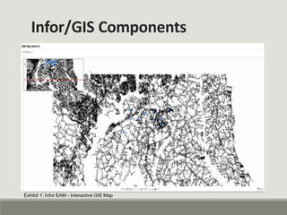
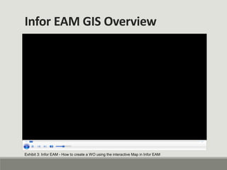
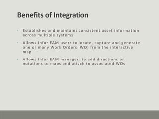
Infor EAM
GIS Integration
Introduction
Charles County utilizes the Infor Enterprise Asset
Management (EAM) system to provide a powerful,
integrated tool to fully manage all aspects of the assets
and work orders of the Department of Public Works. To
maximize the power of this system, the County
synchronized the EAM with the County’s GIS layers,
launched a mobile initiative, and implemented a data
analytics program.
• In 2013 the County Department of Public Works (PW)
initiated the process of incorporating all of its
equipment into the Infor EAM system
• Storing all of their equipment in Infor EAM would
allow PW to track all costs associated with maintaining
County equipment
• To assist in accomplishing this goal PW needed to
synchronize the hundreds of thousands of underground
equipment stored in the ESRI GIS database with Infor
EAM
• As such it was decided that the Infor EAM GIS module
was needed to transfer the data from ESRI GIS to Infor
EAM
Infor/GIS Integration Project
• The Infor EAM and GIS integration was completed in
early 2014
• This integration synchronized over 200,000 pieces of
equipment from the County ESRI GIS system with the
Infor EAM equipment hierarchy
• The integration provided Infor EAM users with the
ability to access detailed interactive GIS map
containing layers, pumps, wells and lateral information
• Additionally the integration allows users to generate
WOs directly from the interactive map; permitting
users unfamiliar with the Infor EAM hierarchy to easily
locate equipment and generate WOs
Infor/GIS Integration
Infor/GIS Components
Exhibit 1: Infor EAM - Interactive GIS Map
Infor/GIS Components
Exhibit 2: Infor EAM - GIS map search
Infor EAM GIS Overview
Exhibit 3: Infor EAM - How to create a WO using the interactive Map in Infor EAM
• Establishes and maintains consistent asset information
across multiple systems
• Allows Infor EAM users to locate, capture and generate
one or many Work Orders (WO) from the interactive
map
• Allows Infor EAM managers to add directions or
notations to maps and attach to associated WOs
Benefits of Integration
Presented by:
Charles County Government
Fiscal and Administrative Services
Information Technology
Mission Statement
The mission of Charles County Government is to provide our
citizens the highest quality service possible in a timely,
efficient, and courteous manner. To achieve this goal, our
government must be operated in an open and accessible
atmosphere, be based on comprehensive long- and short-
term planning, and have an appropriate managerial
organization tempered by fiscal responsibility.
We support and encourage efforts to grow a diverse
workplace.
Vision Statement
Charles County is a place where all people thrive and
businesses grow and prosper; where the preservation of
our heritage and environment is paramount, where
government services to its citizens are provided at the
highest level of excellence; and where the quality of life is
the best in the nation.

Infor gis integration

  • 1.
  • 2.
    Introduction Charles County utilizesthe Infor Enterprise Asset Management (EAM) system to provide a powerful, integrated tool to fully manage all aspects of the assets and work orders of the Department of Public Works. To maximize the power of this system, the County synchronized the EAM with the County’s GIS layers, launched a mobile initiative, and implemented a data analytics program.
  • 3.
    • In 2013the County Department of Public Works (PW) initiated the process of incorporating all of its equipment into the Infor EAM system • Storing all of their equipment in Infor EAM would allow PW to track all costs associated with maintaining County equipment • To assist in accomplishing this goal PW needed to synchronize the hundreds of thousands of underground equipment stored in the ESRI GIS database with Infor EAM • As such it was decided that the Infor EAM GIS module was needed to transfer the data from ESRI GIS to Infor EAM Infor/GIS Integration Project
  • 4.
    • The InforEAM and GIS integration was completed in early 2014 • This integration synchronized over 200,000 pieces of equipment from the County ESRI GIS system with the Infor EAM equipment hierarchy • The integration provided Infor EAM users with the ability to access detailed interactive GIS map containing layers, pumps, wells and lateral information • Additionally the integration allows users to generate WOs directly from the interactive map; permitting users unfamiliar with the Infor EAM hierarchy to easily locate equipment and generate WOs Infor/GIS Integration
  • 5.
    Infor/GIS Components Exhibit 1:Infor EAM - Interactive GIS Map
  • 6.
    Infor/GIS Components Exhibit 2:Infor EAM - GIS map search
  • 7.
    Infor EAM GISOverview Exhibit 3: Infor EAM - How to create a WO using the interactive Map in Infor EAM
  • 8.
    • Establishes andmaintains consistent asset information across multiple systems • Allows Infor EAM users to locate, capture and generate one or many Work Orders (WO) from the interactive map • Allows Infor EAM managers to add directions or notations to maps and attach to associated WOs Benefits of Integration
  • 9.
    Presented by: Charles CountyGovernment Fiscal and Administrative Services Information Technology Mission Statement The mission of Charles County Government is to provide our citizens the highest quality service possible in a timely, efficient, and courteous manner. To achieve this goal, our government must be operated in an open and accessible atmosphere, be based on comprehensive long- and short- term planning, and have an appropriate managerial organization tempered by fiscal responsibility. We support and encourage efforts to grow a diverse workplace. Vision Statement Charles County is a place where all people thrive and businesses grow and prosper; where the preservation of our heritage and environment is paramount, where government services to its citizens are provided at the highest level of excellence; and where the quality of life is the best in the nation.