Leslie Pelch, Outreach Director for Vermont Center for Geographic Information, outlines the benefits and tools for data visualization at 7th Annual Media Maven Luncheon hosted by CCTV and Common Good VT.
Learning to Apply GIS in Interdisciplinary Research: From Theory to PracticePatrick Rickles
This presentation was given at the Royal Geographic Society's Annual Conference (2014) on the findings from interviews with Interdisciplinary Researchers who've learned GIS on what GIS Concepts matter to them (as framed by the Geographic Information Science & Technology Body of Knowledge).
GIS in Education: Across Campuses, Inside FacilitiesEsri
“GIS in Education: Across Campuses, Inside Facilities” presents articles about GIS-based facilities management in schools and universities in areas including planning, portfolio management, operations, maintenance, security, compliance, and sustainability.
“Advancing STEM Education with GIS” includes cases studies detailing the successful implementation of GIS-based STEM classes in both formal and informal settings. Other articles discuss potential career paths and opportunities for collaboration.
Leveraging ArcGIS Platform & CityEngine for GIS based Master PlansEsri India
Sustainable, scalable and future ready urban development is one the key priorities in India as well globally. Major government programs i.e. Smart Cities and Atal Mission for Rejuvenation and Urban Transformation (AMRUT) aim to build foundations to achieve this.
For any planned development, master plan is a starting point. A master plan provides a long term blueprint that guides the sustainable planned development of the city. Use of GIS for master planning is not new. GIS-based Master Plans will help in different types of urban planning exercises, e.g. preparation of development plan, zonal plan, utility plan, infrastructure plan, etc. Even Smart City program and AMRUT programs mandate use of GIS for master plan creation.
ArcGIS is a complete platform for end-to-end city planning, design and management. The webinar illustrates how ArcGIS Platform and 3D capabilities of CityEngine provides a complete set of tools for end-to-end GIS based master plan creation and updation.
A geographic information system (GIS) is a computer system for capturing, storing, checking, and displaying data related to positions on Earth's surface. GIS can show many different kinds of data on one map. This enables people to more easily see, analyze, and understand patterns and relationships.
You Can’t Manage What you Don’t Measure URISA’s Proposed Municipal GIS Capab...Greg Babinski
This presentation was made by Greg Babinski as the luncheon keynote address at the 2011 Alaska State Surveying & Mapping Conference in Anchorage, AK on February 22, 2011.
GIS is a computer-based tool used and managed by people to efficiently capture, store, integrate, analyze and display spatial (geographically referenced) data & associated attribute data
A Proposed Municipal GIS Capability Maturity ModelGreg Babinski
A geographic information system (GIS) has become a common component of city and county governments. All large municipalities and many medium and small sized cities and counties have now established GIS capability.
Just as each municipality is different, municipal GIS operations vary greatly. Partly this variation results from the ongoing development of GIS capability within many city and city and county governments. But how do these agencies know where their GIS development is in relationship to potential capability for similar agencies?
Other agencies consider that their GIS is mature because their implementation project has been completed and they are doing ongoing GIS operations and maintenance. But how do these agencies know if they are lacking basic GIS capability.
Capability maturity models have been used to assess the ability of agencies to develop software successfully. Recently a GIS maturity model was developed to assess state government GIS capability.
This presentation will outline a proposed Municipal GIS Capability Maturity Model and discuss some preliminary results from applying the model to city and county GIS operations in the Pacific Northwest.
This presentation will be of value to managers to self-assess their GIS operation, determine areas for efficiency or effectiveness improvements, assess system risk factors, analyze capability gaps, and prioritize developments required for a mature GIS.
Presented at 2009 WAURISA Conference.
Fairfax County GIS Excellence Awards December 16, 2020Fairfax County
GIS excellence awards for 2020 were presented by Michael Liddle, Director Geospatial Services Division, Department of Information Technology, Fairfax County, VA.
The Use of GIS in Local Government - The City of MonashSteven Truman
The City of Monash as a case study in the use of Geographic Information Systems (GIS) and geographic data in Local government. The city of Monash is located in the south eastern suburbs of Melbourne, Victoria, Australia.
Wireless wan solutions customer presentation at&t_revised2_02-13-2012NGINX at F5
Wireless WAN (WWAN) Connectivity from AT&T can keep your business connected, get your business connected quickly, and enable data transmission and transaction processing from almost anywhere business takes you. Much more than just backup, WWAN is ideal for primary connectivity for lower bandwidth applications in situations where wired networks are unavailable or infeasible.
Benefits
Cost-effective connectivity for low-bandwidth transactional applications
Ubiquitous access from virtually any location via the AT&T network
No lengthy provisioning timeframes
Portable for use in temporary deployments
Wireless Wan Customer Presentation (AT&T)NGINX at F5
Wireless Wan Customer Presentation (AT&T) Wireless WAN (WWAN) Connectivity from AT&T can keep your business connected, get your business connected quickly, and enable data transmission and transaction processing from almost anywhere business takes you. Much more than just backup, WWAN is ideal for primary connectivity for lower bandwidth applications in situations where wired networks are unavailable or infeasible.
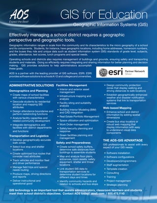
1. Effectively managing a school district requires a geographic
perspective and geographic tools.
Geographic information ranges in scale from the community and its characteristics to the micro geography of a school
and its components. Students, for instance, have geographic locations, including home addresses, homeroom numbers,
and the buses they ride and unique data such as student information system (SIS) standards of grade level, subjects,
grades, attendance, test scores, lunch programs and special needs.
Operating schools and districts also requires management of buildings and grounds, ensuring safety and transporting
students and materials. Doing so efficiently requires integrating and sharing information for better planning and decision
making. GIS provides solutions to help administrators accomplish
these goals.
AOS is a partner with the leading provider of GIS software, ESRI. ESRI
provides software solutions to schools K-12 and colleges and universities.
ADMINISTRATIVE SOLUTIONS
Demographics and Planning
• Create maps of school facilities
with various characteristics
• Geocode students by residential
location and mapping SIS
attributes
• Design attendance boundaries and
perform redistricting functions
• Analyze facility capacities and
related community development
• Integrate demographics and
facilities with district departments
and functions
Transportation and Logistics
• Develop geographically-accurate
walk zones
• Select bus stop and shelter
locations
• Create optimized bus routes that
consider road attributes
• Track vehicles and monitor fleet
and driver performance
• Manage field trips and special
needs routing
• Produce maps, driving directions
and reports
• Deliver instructional and
operational good
Facilities Management
• Interior and exterior asset
management
• Infrastructure mapping and
analysis
• Facility siting and suitability
analysis
• Building Interior Modeling (BIM)
and CAD integration
• Real Estate Portfolio Management
• Space utilization and optimization
• Work Order management
• Safety/security planning and
response
• Green facilities planning and
management
Safety and Preparedness
• Create school safety buffers,
determine safe distances from
buildings to assemble students
• Map and analyze floor plans,
entrances, room assets, safety
equipment, shelter and threat
locations
• Link student SIS data to
transportation services to
determine student locations for
different days and times
• Identify community hazards and
relation to schools and bus stops
• Design community protection
zones that display walking and
driving distances to safe locations
• Establish geographically-enhanced
weather and disaster notification
systems that link to transportation
services
Web-based Mapping
• Enhance school and district
information by adding spatial
dimensions
• Create bus stop locators or
robust web mapping that
display information with easy
to understand visual data
components
THE AOS-GIS ADVANTAGE
GIS professionals to assist with every
aspect of your GIS needs:
• Software installation
• Software configurations
• Developers/programmers
• Staff augmentation
• Template creation
• Consulting
• Training
• Project management
• Strategic planning
GIS for Education
Geographic Information Systems (GIS)
GIS technology is an important tool that assists administrators, classroom teachers and students
meet their school district’s objectives. Contact AOS today! aos5.com / 800.473.1110
2. Geographic Information
Systems (GIS)
Geographic information systems or GIS, integrates
hardware, software and data for capturing, managing,
analyzing and displaying all forms of geographically
referenced information.
GIS provides methods to view, understand, question, interpret and visualize data in many ways that
reveal relationships, patterns and trends in the form of maps, globes, reports and charts. GIS helps
answer questions and assists in solving problems by looking at data in a way that is quickly understood
and easily shared.
AOS is a partner with the leading provider of GIS software, ESRI. ESRI provides their software solutions
to not only the government and education sector but to large corporations and small businesses
as well.
MAJOR BENEFITS OF USING GIS:
• Cost savings and increased efficiencies
• Better decision making
• Improved communications
• Better recordkeeping
• Managing geographically
USING GIS IN LOCAL GOVERNMENT
Local governments use GIS to assist in areas
including; public works, 911, law-enforcement,
appraisers and health agencies just to name a few
that benefit from GIS solutions. GIS consistently
delivers a return on investment including:
• Cost avoidance
• Time savings
• Increased accuracy
• Higher productivity
• Better decision making
• Increased citizen engagement
• Green government initiatives
THE AOS-GIS ADVANTAGE
GIS professionals to assist with every aspect of your
GIS needs:
• Software installation
• Software configurations
• Developers/programmers
• Staff augmentation
• Template creation
• Consulting
• Training
• Project management
• Strategic planning
AOS is a ESRI Silver Partner!
For more information visit www.aos5.com.