Geotourism menu incline
•
1 like•378 views

I will upload a more current version, as this one was written 5 years ago As Tahoe's Geotourism Liaison (appointed by National Geographic Center for Sustainable Destination in May 2007), and Executive Director of Sustainable Tahoe, my mission is to inspire the Tahoe traveler to choose activities, adventures and experiences that will sustain or enhance the unique geographical, cultural, aesthetic, heritage and local well being of the Lake Tahoe watershed. Please let me know how this has enlightened you easy fun ways YOU can deepen your connection to the 8 Wonders of Tahoe, while reducing your carbon footprint. In Service to Sustainable Prosperity with Water Clarity, Jacquie

Recommended
More Related Content
What's hot
What's hot (14)
Similar to Geotourism menu incline
Similar to Geotourism menu incline (18)
More from Jacquie Chandler
More from Jacquie Chandler (20)
Recently uploaded
Recently uploaded (20)
Geotourism menu incline
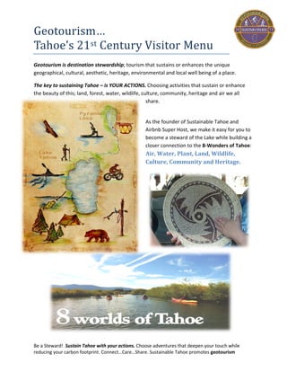
- 1. Be a Steward! Sustain Tahoe with your actions. Choose adventures that deepen your touch while reducing your carbon footprint. Connect…Care…Share. Sustainable Tahoe promotes geotourism Geotourism… Tahoe’s 21st Century Visitor Menu Geotourism is destination stewardship; tourism that sustains or enhances the unique geographical, cultural, aesthetic, heritage, environmental and local well being of a place. The key to Sustaining Tahoe is by choosing activities that sustain or enhance the beauty of this land, forest, water, wildlife, culture, community, heritage and air we all share. Sustainable Tahoe makes it easy for you to become a steward of the Lake while building a closer connection to the 8- Worlds and wonders of Tahoe: Air, Water, Plant, Land, Wildlife, Culture, Community and Heritage.
- 2. Be a Steward! Sustain Tahoe with your actions. Choose adventures that deepen your touch while reducing your carbon footprint. Connect…Care…Share. Sustainable Tahoe promotes geotourism Kayak, SUP or Swim Best way to experience the ‘Temple of Tahoe’ is to float on it. Kayak or SUP from Incline Village to Hidden Beach, or Sand Harbor to Thunderbird Lodge. Follow the shoreline and you will weave through massive boulders, past caves, Mark Twain landmarks and arbor islands, possibly see an eagle nest, geese, or crayfish crawling along the water’s edge. It takes 7,000 years for the Lake to completely refresh its water, so the activities we choose have an impact. The lower the carbon impact the better for the future of our National Treasure. Kayaks and SUP boards are carbon-free way to deepen your connection to the water while helping to preserve it. Equipment can be rented at Incline Beaches, Sand Harbor and the Hyatt.
- 3. Be a Steward! Sustain Tahoe with your actions. Choose adventures that deepen your touch while reducing your carbon footprint. Connect…Care…Share. Sustainable Tahoe promotes geotourism Bike the Flume 1870s Water Flumes, or elevated wooden channels, transported water from Marlette Lake to Incline Village lumber operations. From there water carried trees through an underground pipeline that took them all the way to Virginia City to support silver mining operations during the Comstock Era. 1983 Max Jones, a professional mountain biker seeing potential for an epic ride, spent his summer clearing brush, boulders and hacking through abandoned aluminum pipes by himself with nothing more than hand tools. Only during the final few days did he convince a local forest ranger to let him bring a chain saw to clear final debris and reveal a passable, and now world-class mountain bike trail. 1) $17 Shuttle from Tunnel Creek Station to Spooner Lake. Ride 5 mile 1,000 ft assent on fire road to Marlett Lake. X creek onto Flume Trail. Ride 4.5 miles to Tunnel Creek Trail and descend 800 ft to Tunnel Creek Station, 3 miles and ride 1 mile back to house. 2) $15 Shuttle from Tunnel Creek Station to Tahoe Rim Trail on Mt Rose. Ride 9 miles on the Rim Trail (some technical but easy 200 ft gradual assent) to Tunnel Creek Trail. Head up Tunnel Creek to Flume and ride as much of the 4.5 miles as you like. Turn around at Marlett (or before) and head back to Tunnel Creek Trail and descend 800 ft in 3 miles to Tunnel Creek Station. Ride one mile back to house. For Shuttle Information: Tunnel Creek Station 775-298-2501 info@flumetrailbikes.com You can rent bikes at the Station, enjoy food and drink at Café and thank Max for making this trail possible.
- 4. Be a Steward! Sustain Tahoe with your actions. Choose adventures that deepen your touch while reducing your carbon footprint. Connect…Care…Share. Sustainable Tahoe promotes geotourism
- 5. Be a Steward! Sustain Tahoe with your actions. Choose adventures that deepen your touch while reducing your carbon footprint. Connect…Care…Share. Sustainable Tahoe promotes geotourism Incline Flume Trail (bike or hike) Incline Flume holds remains of the only Bull Wheel ever used in logging history. From 1880 to 1894, two steam-powered wheels hauled hundreds of cords of lumber a day up a 1,400 ft incline that were then floated, via a large wooden water flume, 3,994 feet through a mountain tunnel. Although the tunnel collapsed in 1957, remnants of the flume that carried the lumber are evident on the Incline and Marlette Flume hiking and biking trails. Today it is a ‘social trail’ off Mt Rose about 0.5 miles beyond the scenic lake view point. There is a small dirt parking lot (5 cars max) or you can park across the hwy in a large pullout area. Be careful Xing. The Bike ride is 100 ft max climbing, some technical over creeks and rocks with awesome lake views and maximum downhill at the end. (FYI: private property section is now public) Trail Navigation: 1st Fork go LEFT. 2nd ‘K’ Fork go Left cross intersecting trail, then go RIGHT The trail traverses through forests of red fir, Jeffrey pine (3-needle), white pines (5-needle), and lodge pole pines (2- needle). Ride #1: 4-mile single track trail to Diamond Peak Ski Resort. Choose (easy) ski run down the mountain. Ride #2: 9 mile ride past Diamond Peak to Tunnel Creek Trail and head down sandy switchbacks to Tunnel Creek Café. Ride #3: 24 mile ride: When you get to Tunnel Creek Trail turn up and ride to the intersection of the FLUME – go right and follow the Flume to Marlett Lake where you turnaround and back track to Tunnel Creek, head down and follow instructions back to house. Note: if you choose the Tunnel Creek trail, stop off at the Mark Twain bench, to enjoy “the fairest picture the whole world affords”. Options to get to Trailhead: 1) Drive to Mt Rose trailhead … hike/bike in and back out. 2) Leave a car at Diamond Peak or Tunnel Creek Station drive 2nd car to trailhead, ride to where you parked 1st car.
- 6. Be a Steward! Sustain Tahoe with your actions. Choose adventures that deepen your touch while reducing your carbon footprint. Connect…Care…Share. Sustainable Tahoe promotes geotourism
- 7. Be a Steward! Sustain Tahoe with your actions. Choose adventures that deepen your touch while reducing your carbon footprint. Connect…Care…Share. Sustainable Tahoe promotes geotourism Bus to North Tahoe Beach Walk While it is impossible to circle the lakefront on sand, there are a few spots where you can get a mile or more walk in, (esp. with drought low water). Here is a close and easy one using a beautiful Bus ride from Incline! 1) Take TART from Incline Village (on Hwy 28 across from Visitor Center, or in front of Raleys (leave car in lot). 2) Take TART to bus stop in front of Safeway right past the Hwy 287 intersection (first stop in Tahoe Vista). Right across the street you will see the North Tahoe Beach entrance. Open beach to your left and right. If you go right toward downtown Kings Beach, Java Hut makes for a nice beverage stop, just off the sand. 3) When you are ready to return, you just catch the nearest bus…you are car-free!
- 8. Be a Steward! Sustain Tahoe with your actions. Choose adventures that deepen your touch while reducing your carbon footprint. Connect…Care…Share. Sustainable Tahoe promotes geotourism Creek Walk 1) From Lakeshore Blvd. catch the path just left of the Hyatt driveway and over-pass pedestrian tunnel…head toward the bridge. 2) Follow the path over the bridge along the creek under a canopy of trees. Take time to enjoy the benches along the way and tune into the water song. 3) The trail will come out on Incline Way. Cross over the street to heading toward the college. The path goes along a wooden post fence to the Demonstration Garden. Learn about our native and not so native plants. To your right past the garden will be the Tahoe Science Center, with wonderful interactive displays.
- 9. Be a Steward! Sustain Tahoe with your actions. Choose adventures that deepen your touch while reducing your carbon footprint. Connect…Care…Share. Sustainable Tahoe promotes geotourism Hike to Hidden Beach Tunnel Creek was named for the tunnel that moved timber on a water flume through a mountain to Carson City in the 1800’s. Tunnel Creek Station was also part of Ponderosa Ranch - the setting for the 1960’s TV show ‘Bonanza’. Easy 2 mile round trip walk from Tunnel Creek Station to Hidden Beach. 1) Drive, Bike or walk to Tunnel Creek Station and Café. Parking lot reserved for Café patrons, so park on hwy shoulder if you’re not eating or drinking at the Café. 2) Head up the paved road to the left of the café. You will come to the NV State Parks sign at top and lake views begin. Note: NV Parks recently installed a use permit box, so it may cost a $1 to use the trail. 3) 4) Follow the fire road (with amazing views) past the green gate to the fork and head down the fork, cross the hwy (head to your right), cross over the guard rail to the path that heads down the beach. 5) Leaving the beach, you can go back the way you came or take the trail along the beach, inside the guard rail of hwy back to Incline. The trail ends about 1/4 mile from Tunnel Creek Station, so there is some hwy shoulder walking. Be safe and ENJOY!!!
- 10. Be a Steward! Sustain Tahoe with your actions. Choose adventures that deepen your touch while reducing your carbon footprint. Connect…Care…Share. Sustainable Tahoe promotes geotourism
- 11. Be a Steward! Sustain Tahoe with your actions. Choose adventures that deepen your touch while reducing your carbon footprint. Connect…Care…Share. Sustainable Tahoe promotes geotourism Bike - West Shore & Truckee River Easy Class 1 (paved path ) Bike ride to bring you closer to the water, wildlife and wonder of Tahoe’s West Shore & Truckee River (the river leaving Lake Tahoe headed NE to Pyramid Lake). Taking TART (bus) to get you to Tahoe City, provides freedom from traffic , parking and allows everyone to enjoy the view. You can start your ride along the Truckee River , come back to the bus terminal and take off on the path along the Lake. Lots to stop and explore along the way. The bike ride from Tahoe City to Squaw Valley is about 6 miles (one way). From Transit Center to Tahoe Pines is also about 6 miles (one way). 1) Ride bikes to TART Bus Stop on Hwy 28 (take Country Club to Hwy 28) Bus leaves 40 mins after each hour. 2) Take TART to Tahoe City Bus Terminal (64 Acres) 3) Ride over bridge to path that will take you to the trail along Truckee River. You can ride to River Ranch (restaurant with patio dining) or Squaw Valley and then turn around and head back to Tahoe City where you take paved bike trail along the West Shore. 4) Additional Attractions: Sugar Pine Park ‘s Old Growth Sugar pines and Ehrman Mansion. Maritime Museum in Homewood. (Fees apply) 5) Lunch stops: Gatekeepers Museum picnic area (if you have food), or enjoy one of many deli / cafes along route: Syds’ (Tahoe City) Granlibackken, PDQ Market, Obexers (near Homewood). 6) When ready, jump back on TART as it moves north along West Shore. Use the Next Bus App to confirm stops or schedule. Enjoy!
- 12. Be a Steward! Sustain Tahoe with your actions. Choose adventures that deepen your touch while reducing your carbon footprint. Connect…Care…Share. Sustainable Tahoe promotes geotourism
- 13. Be a Steward! Sustain Tahoe with your actions. Choose adventures that deepen your touch while reducing your carbon footprint. Connect…Care…Share. Sustainable Tahoe promotes geotourism Birding in Tahoe While you have to be an early bird to see them, the Village Green in Incline, Mt Rose Meadow (Hwy 431), Spooner Lake (Hwy 28) and Tailor Creek (South Shore) are favorite bird watching places. Better yet, join a guided hike with one of our local experts and learn while you view! Will and Kirk from Tahoe Institute of Natural Science www.tinsweb.org guide bird hikes. Call 775 298-0060 or check website calendar. Will 530-587-6895 or Kirk 775 298-0065
- 14. Be a Steward! Sustain Tahoe with your actions. Choose adventures that deepen your touch while reducing your carbon footprint. Connect…Care…Share. Sustainable Tahoe promotes geotourism Bonanza Museum In 431 episodes spanning from 1959 to 1973, the Cartwright’s of the Nevada Territory's Ponderosa became a fixture of American life. The opening scene for the 1050’s famous TV Show Bonanza was shot in Incline Village including the original set for the Ponderosa Ranch. Loren Greene’s son Chuck Greene made his collection of the TV Shows’ memorabilia available to the museum. There are also stories and displays about other colorful characters who influenced and shaped the culture of this area. Among then Mark Twain… Incline’s own McAvoy Layne provides entertainment at the museum bringing Mark Twain’s unique perspective back to life. Check museum out in the Starbucks Building Hwy 28 and Village (center of Incline Village)
- 15. Be a Steward! Sustain Tahoe with your actions. Choose adventures that deepen your touch while reducing your carbon footprint. Connect…Care…Share. Sustainable Tahoe promotes geotourism Tahoe’s ‘Wild Beaches’ Tahoe’s ‘Wild Beaches’ begin 6 miles from house headed south along Hwy 28.. They are free to access with hiking and limit provisions. There is a State parking lot (free) if you get there early, otherwise it is shoulder parking ( not so good for the Lake and increases traffic problems), so try for the parking lot. They are pack-it-in and pack-it-out beaches, depending on the stewardship of all. There is a restroom at the parking lot.
- 16. Be a Steward! Sustain Tahoe with your actions. Choose adventures that deepen your touch while reducing your carbon footprint. Connect…Care…Share. Sustainable Tahoe promotes geotourism
- 17. Be a Steward! Sustain Tahoe with your actions. Choose adventures that deepen your touch while reducing your carbon footprint. Connect…Care…Share. Sustainable Tahoe promotes geotourism Dog Friendly Ski Beach In winter months (Oct 15 to April 15), Ski Beach in Incline Village allows dogs! There is a small parking area right inside the gate (which is unmanned in winter), or you can park across the street at the Village Green where the large open area (grass or snow) is also a Dog Park. Either place your dog can run free and socialize with other dogs as you enjoy epic views of the lake and forest. There are dog poop collection bags at both places. It is very important that you clean up after your dog, as everything that falls on the ground goes into the Lake and that is the water we all drink. Great place to meet locals, other travelers and give your dog some social time while you baste in the beauty of the Lake.
- 18. Be a Steward! Sustain Tahoe with your actions. Choose adventures that deepen your touch while reducing your carbon footprint. Connect…Care…Share. Sustainable Tahoe promotes geotourism North Tahoe Disc Golf Course Test your toss skills at Incline’s own Disc Golf Course! A multi use area enjoyed by all ages, this 18 par 3’s is a challenging course in a forest setting along Hwy 28, next to the Visitors center, adjacent to the Incline Tennis Center, Recreation Center on Incline Way, and the skateboard park and the ball fields off Southwood. Park at the Recreation Center located at 980 Incline Way (but not at the Incline Tennis Center).The 1st hole is located on the west side of the Recreation Center entrance road. Be mindful of the rules, watch out for branches, bring lots of friends and enjoy! The TART bus stop is right across the street on Hwy 28 if you like to be car-free!
- 19. Be a Steward! Sustain Tahoe with your actions. Choose adventures that deepen your touch while reducing your carbon footprint. Connect…Care…Share. Sustainable Tahoe promotes geotourism Incline Village Resident Beaches Three local Resident Beaches open to residents and their guests. Residents can buy guest passes are $12 per adult and $4 per child. Children under 6 yrs are free. Ski Beach has Boat Ramp, Volley Ball Courts, access to hermit Beach, kayak racks and no Parking..You park across street at the Village Green. Incline Beach has a kids playground, picnic tables, BBQ pits, lounge chairs, shade trees, food and Drink Bar, evening music and Parking on site, if you get there early. Easy bike ride or walk from house. Burnt Cedar Beach has playground, grass area, picnic and group areas, swimming & toddler pool, Club House, Food, lounge chairs and parking on site if u get there early. All 3 off Lakeshore Blvd. They check passes 8am to 7pm
- 20. Be a Steward! Sustain Tahoe with your actions. Choose adventures that deepen your touch while reducing your carbon footprint. Connect…Care…Share. Sustainable Tahoe promotes geotourism
- 21. Be a Steward! Sustain Tahoe with your actions. Choose adventures that deepen your touch while reducing your carbon footprint. Connect…Care…Share. Sustainable Tahoe promotes geotourism Fall Immersion at Spooner Lake Aside from being the best place near Incline to immerse yourself in the fall palette, Spooner Lake is also home to the largest Aspen grove in Tahoe. Spooner Lake was also a summer home for the original people of this land, the Washoe. You can find some grinding rocks near the lakes edge, as the Washoe outdoor kitchens seem to prefer great views. The 2-mile loop takes you through a variety of terrains and wildlife habitat. Look up, sideways, as well as down, since many native Tahoe locals call this place home: Mule Deer, chipmunks, squirrels, raccoons, coyotes, eagles, variety of birds and our Black Bears (not harmful to humans, only looking for food). Part of the trail is also the access route to the famous Flume Trail, so watch for bicycles. In the winter, the groomed trails make fore excellent cross country skiing, or snow shoe. For details on access search NV State Parks: http://parks.nv.gov/parks/marlette-hobart- backcountry/
- 22. Be a Steward! Sustain Tahoe with your actions. Choose adventures that deepen your touch while reducing your carbon footprint. Connect…Care…Share. Sustainable Tahoe promotes geotourism Mt Rose Meadow: Hike, X-Country Ski, Snow Shoe Mt Rose Meadow is a 6 mile drive from Incline. Take Mt Rose Hwy 431 uphill until you see the large open meadow, Park on the Right Side (near the tree line if possible) A family fun activity of recreation and wildlife viewing. Wildlife can be anywhere at any time, but the Chickadees tend to be in the trees, as you head to the back of the meadow or into the trees up the hill to see the view (also known as “Chickadee Hill”). Bring a sack of bird seed if you plan to feed them. However even just holding out your hand, they may land, as they have become very friendly toward respectful humans.
- 23. Be a Steward! Sustain Tahoe with your actions. Choose adventures that deepen your touch while reducing your carbon footprint. Connect…Care…Share. Sustainable Tahoe promotes geotourism Sledding and Skating Sledding Mt Rose Meadows for sledding. Park on the left side of Hwy 431 as you head up from Incline. Bring your sleds, hike up the hill and fly down. Skating The Truckee Ice Rink located in Truckee Regional Park. Scheduled to open at 10a. this outdoor rink is somewhat of a locals’ secret. Located 1/2 mile south of Downtown Truckee in the Truckee River Regional Park on Old Brockway Rd. Truckee Ice Rink features public skating, skate rentals, a snack bar, group and private lessons for all age groups taught by experienced instructors, broomball leagues, and more! The outdoor setting under tall pines, complete with bonfire, overhead lights, and music to skate by, makes for a truly enjoyable outing. FEES: District Residents: Adult $5, Child $3 Non-Residents: $6 SKATE RENTALS: $2
- 24. Be a Steward! Sustain Tahoe with your actions. Choose adventures that deepen your touch while reducing your carbon footprint. Connect…Care…Share. Sustainable Tahoe promotes geotourism
- 25. Be a Steward! Sustain Tahoe with your actions. Choose adventures that deepen your touch while reducing your carbon footprint. Connect…Care…Share. Sustainable Tahoe promotes geotourism Winter Sleigh Rides A fun and unique way to tour the famous Sand Harbor in the winter is by sleigh ride! The Belgium Draft Horse knows the route and your Borges family Tour Guide knows the history, nostalgia and fun facts about Tahoe and this boulder beach paradise on the East Shore. Sand Harbor is 3 miles from Country Club in Incline, heading south on Hwy 28.Lake Tahoe Blvd. Call to reserve your time and space 775 588-2953 http://www.sleighride.com
- 26. Be a Steward! Sustain Tahoe with your actions. Choose adventures that deepen your touch while reducing your carbon footprint. Connect…Care…Share. Sustainable Tahoe promotes geotourism Sand Harbor – sun fun to star gazing Sand Dunes once covered the area now called Sand Harbor. If you are seeking one of Nevada’s premier State Beaches, showcasing the signature beauty of huge granite boulders against blue water – this is it! Great for swimming, SUP, Kayak, picnicking, exploring, or star gazing at night. The onsite Heritage Museum features the native Washoe Tribe story. A stroll along the wooden walkway weaves between Jeffery Pines and granite boulder coves. Be sure to get there early in summertime. Parking fee: $8 for NV $10 for CA. Tahoe Express Bus (picks up Mays and Southwood. $3 per person (includes park fee). Leaves every 20 minutes from 9AM to 5PM. Save money and be car-free!
- 27. Be a Steward! Sustain Tahoe with your actions. Choose adventures that deepen your touch while reducing your carbon footprint. Connect…Care…Share. Sustainable Tahoe promotes geotourism
- 28. Be a Steward! Sustain Tahoe with your actions. Choose adventures that deepen your touch while reducing your carbon footprint. Connect…Care…Share. Sustainable Tahoe promotes geotourism Tahoe in Depth Lake Tahoe’s story begins 400Million yrs ago! Learn the secrets of this small and unique watershed, what local Limnologists are doing to help us protect it and what you can do to ensure it stays clear for years. Come for the fun and leave fortified with a deeper perspective and love for this special watershed.. • Virtual tour on Research Boat • Explore the water Lab • Watch a 3D Visualization of how Tahoe formed • Dive in at the interactive sandbox • Tour the Leed-Certified Green Building • Explore diversity at the Demonstration Garden Located on Sierra Nevada College Campus 291 Country Club Dr, Incline Village (775) 881-7566 Tuesday - Friday 1:00PM to 5:00PM Memorial Day through Labor Day Saturdays 1:00 – 5:00PM Guided Tours start on the Hour
- 29. Be a Steward! Sustain Tahoe with your actions. Choose adventures that deepen your touch while reducing your carbon footprint. Connect…Care…Share. Sustainable Tahoe promotes geotourism Local Night-Life Culture Alibi for ‘Paint and Pint’ on Thursdays! BREWERY AND PUBLIC HOUSE IN NORTH LAKE TAHOE 204 EAST ENTERPRISE, INCLINE VILLAGE, NEVADA 89451 775.298.7001 TAP ROOM HOURS Monday 3-10pm HAPPY HOUR ALL NIGHT Tuesday 3-10pm TRIVIA NIGHT Wednesday 3-10pm POP UP SUSHI NIGHT Thursday 3-11pm OPEN MIC NIGHT Friday 12-11pm Saturday 12-11pm LIVE MUSIC Sunday 12-8pm DISCOUNT GROWLER DAY Both locally owned and operated Crystal Bay Club Live entertainment, gambling, dining and $3.33 breakfast at Café Elise (before 11am) 775 833-6333