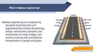
Role of Geology
in Highways, Foundations, Airfileds, and bridges
Asalam o Alikum
Myself Noor Hassan
I am here as group Representator,
The Topic we got assigned today is Role of Geology.
2
Group members
Noor Hassan
 F21601053
Bridges
Umar Farooq
F2101051
 Foundations
3
Saad Saddique
F21601023
Highways
Muhammad Mughira Saad
F21601001
Highways
Malik Muhammad Danish Faraz
F21601019
Airfields
Foundations
Umar Farooq
F21601051 4
Objectives
 To know the construction of foundation.
 To know the different types of foundation.
 To know which types of foundation is
suitable for different types of soil.
5
5
Foundation
Every structure consist of two parts;
 Sub-structure or foundation
 Super-structure
Foundation:
It is the lowest part of structure which is constructed below
the ground level.
 The function of foundation is to transmit the weight of super structure
to the sub soil.
6
Types of Foundations
1. Shallow Foundation
 Wall Foundation
 Isolated column
foundation
 Combined foundation
 Mat or Raft foundation
2. Deep Foundation
 Pile foundation
 Under-Reamed foundation
 Well Foundation
7
7
8
Isolated Footing
 It is provided under columns to transfer the
load safely to the bed soil.
 These footing may be slab , stepped or
sloped ones.
9
9
10
Mat Foundation
 It is most suitable foundation when the soil at the site
proposed for the construction of a structure is erratic,
soft clay, made up ground or marshy land with low
bearing capacity.
 Mat foundation is constructed of RCC slab covering
the whole area of the bottom of structure. The slab is
provided with steel reinforcing bars in both directions.
When column loads are heavy, the main beams and
secondary beams are provided monolithically with
raft slab 11
11
12
A PICTURE IS WORTH A THOUSAND WORDS
Pile Foundation
 Pile foundation is more commonly used in building
construction.
Pile foundation are used in the following situations;
 The load of the super structure is heavy and its distribution
is uneven.
 The top soil has poor bearing capacity.
 The subsoil water level is high.
 There is large fluctuation in sub soil water level.
 Canal or deep drainage lines exist near the foundation.
 The structure is situated on the sea shore or river bed. 13
13
Pile Foundation
End bearing pile:
 These piles are used to transfer load
through water or soft soil to a
suitable bearing stratum.
14
Pile Foundation
Compaction Pile:
These piles are used to
compact loose soil, thus increasing their
bearing capacity. The compaction piles
themselves do not carry any load. Hence
they may be of weaker material(sand). The
pile tube, driven to compact the soil, is
gradually taken out and sand is filled in its
place thus forming a ‘sand pile’
15
Pile Foundation
Under Reamed Pile
 In black cotton soils and other expansive type of
soils, buildings often crack due to relative ground
movements. This is caused by alternate swelling
and shrinking of the soil due to change in its
moisture content.
 The under-reamed pile is used to safe guard this
movement effectively. Generally this foundation is
used for machine foundation, factory building,
transmission line towers and tall structures also.
16
Well Foundation
 Well foundation is a box of timber, metal, reinforced
concrete or masonry which open both at top and
bottom, and is used for building and bridge
foundations
Types of well shapes;
 Circular
 Rectangular
 Double-D
 Twin circular etc. 17
18
Air Fields
M. M. Danish Faraz
F21601019
19
Airfields
An Airport is a location with facilities for commercial aviations flights to
take off and land.
 It has facility to store and maintain air craft and a control tower.
 Airport with helipad for rotorcraft but no runway is called heliport.
 Airport for use by seaplanes and amphibious aircraft is called
seaplane base.
20
Construction
Airport survey
 Data and details collected during preliminary survey and properly analyzed.
Objectifies of survey
 To ascertain the characteristic of soil.
 To collect details which are essential for design of various components of an airport.
 To democrat the ground on plan and to initiate the hand acquisition proceedings.’
 To give an idea of meteorological conditions prevailing at the proposed site.
 To make provision for future extension of airport.
 To prepare suitable drawings.
 To submit report for getting sanctions of concerned competent authority.
 To suggest the measures, if any, to improve the existing site conditions 21
Types of Survey
There are seven types of surveys
 Approach zone survey.
 Drainage survey
 Meteorological survey
 Natural resources survey
 Soil survey
 Topographical survey
 Traffic survey
22
Types of Survey
Approach zone survey
 To indicate the wide clearance area on either side of the
runway along the direction of landing and take off of an
airport.
Drainage survey
 To have complete data about the sources of water and
qualities of water to be handled near airport site.
 The water reaching the airport has to be intercepted and
directed in proper way.
23
Types of Survey
Metrological survey:
 Science of atmosphere and its phenomenon is known as metrology
 The study of weather and climate is made and if required help of an experienced mythologist is also taken.
 Data to be collected in the survey can be enumerated as follow.
i. Barometric pressure
ii. Direction, duration and intensity
iii. Prevailing Wind
iv. Frost and Fog
v. Periods of low visibility
vi. Rainfall intensity and duration
vii. Snow fall
viii. Temperature etc.
24
Types of Survey
Natural resources survey:
 Survey is aimed to collect complete information about the locally available construction
material, their verities and qualities.
Soil Survey:
 To carry out the design of pavement.
 To decide the best location of various drainage structure.
 To determine whether or not the sub grade soil requires to be improved so as to increase its
bearing capacity
25
Types of Survey
 Methods;
I. Test pits
II. Probing
III. Auger boring
IV. Wash boring
V. Test pile
VI. Deep boring
26
Types of Survey
Topographical Survey:
 To describe the nature of property to be acquired.
 To estimate exaction qualities.
 To prepare an accurate map showing roads, hills, property lines,
streams, buildings and other physical features of airport site.
Traffic Survey:
 Investigations are carried out to predict the probable amount of
traffic including the expected future traffic.
27
Highways
Mughira Saad F21601001
Saad Siddique F21601023
28
What is highway engineering?
Highway engineering is an engineering
discipline branching from civil
engineering that involves the planning,
design, construction, operation, and
maintenance of roads, bridges, and
tunnels to ensure safe and effective
transportation of people and goods.
29
Role of Geology in HIGHWAYS
 Geological investigations play important role in the
design, stability and economical construction and
maintenance of the roads.
 Such investigations are aimed at providing full details
regarding topography of the area, lithological
characters of the rocks or soil and the ground water
conditions.
30
Topography
 Topography or the landform of a region is single most important
factor that controls the selection of alignment of a road project.
 Topographic maps would reveal the existence of various land
features like valleys and the inflowing streams, the hills and their
undulations, the plateaus and the plains with all their varying
configuration from place to place.
 Obviously, knowledge of all such features is not only important
but very essential for a right alignment.
 Preliminary surveys, including aerial surveys followed by detailed
surveys are often necessary to obtain desired topographical
31
Lithological Character
Ground may be divided into two types:
 1. Consolidated, massive hard rock type
 2. Soft, unconsolidated type.
The Massive groups of rocks
 Include all varieties of igneous, sedimentary and metamorphic rocks
which can stand even with vertical slopes.
 For making roads through them, however, these rocks require
extensive blasting operations.
 They cannot be simply cut out or dug out, once cut, especially if they
are free from joints and fractures and un favorably inclined bedding
planes, these rocks stand erect for year without much maintenance.
32
The Unconsolidated group
 Presents the engineer many complicated problems.
Thorough soil investigations regarding their mode of origin,
texture, structures, porosity, permeability, degree of
compaction, consolidation characteristics or
compressibility, etc all are required to be known within broad
limits to design safe and stable roads over them.
 Residual soils are generally homogeneous and properties
evaluated from selective bore hole samples might prove
sufficient.
33
Geological Structures
 The structural features of rocks, especially in those of sedimentary
and metamorphic origin, have very important bearing upon the design
of cuts as well as on the stability of the road as a whole.
 A given rock might be quite hard and otherwise sound for a cut as
road foundation.
 But, if in the same rock some planes of weakness (such as bedding
planes, joints, foliation, cleavage) are present in such a way that
these are inclined towards the free side of the valley, the rock could
likely fail along these planes.
 Such structural features include dip and strike, joints, fault planes and
shear zones 34
Dip and Strike.
There may be three possibilities for making a cut in the inclined
beds:
 1. It can be made parallel.
 2. at right angles.
 3. Inclined to the dip direction.
The relative merits of the cut would be as follows assuming
other things are favorable:
35
Dip and Strike.
Cut is parallel to the dip direction:
 In such a case, the layers offer a uniform behavior on either
side of the cut and as such the risk of failure is minimal on
this account.
Cut is made parallel to the strike:
 That is, at right angles to the dip direction. In some cases
where the layers dip into the hill rather than in the road, the
cut is considered quite stable
36
Dip and Strike.
37
Thank You
38

Geology presentation

  • 1.
    Role of Geology inHighways, Foundations, Airfileds, and bridges
  • 2.
    Asalam o Alikum MyselfNoor Hassan I am here as group Representator, The Topic we got assigned today is Role of Geology. 2
  • 3.
    Group members Noor Hassan F21601053 Bridges Umar Farooq F2101051  Foundations 3 Saad Saddique F21601023 Highways Muhammad Mughira Saad F21601001 Highways Malik Muhammad Danish Faraz F21601019 Airfields
  • 4.
  • 5.
    Objectives  To knowthe construction of foundation.  To know the different types of foundation.  To know which types of foundation is suitable for different types of soil. 5 5
  • 6.
    Foundation Every structure consistof two parts;  Sub-structure or foundation  Super-structure Foundation: It is the lowest part of structure which is constructed below the ground level.  The function of foundation is to transmit the weight of super structure to the sub soil. 6
  • 7.
    Types of Foundations 1.Shallow Foundation  Wall Foundation  Isolated column foundation  Combined foundation  Mat or Raft foundation 2. Deep Foundation  Pile foundation  Under-Reamed foundation  Well Foundation 7 7
  • 8.
  • 9.
    Isolated Footing  Itis provided under columns to transfer the load safely to the bed soil.  These footing may be slab , stepped or sloped ones. 9 9
  • 10.
  • 11.
    Mat Foundation  Itis most suitable foundation when the soil at the site proposed for the construction of a structure is erratic, soft clay, made up ground or marshy land with low bearing capacity.  Mat foundation is constructed of RCC slab covering the whole area of the bottom of structure. The slab is provided with steel reinforcing bars in both directions. When column loads are heavy, the main beams and secondary beams are provided monolithically with raft slab 11 11
  • 12.
    12 A PICTURE ISWORTH A THOUSAND WORDS
  • 13.
    Pile Foundation  Pilefoundation is more commonly used in building construction. Pile foundation are used in the following situations;  The load of the super structure is heavy and its distribution is uneven.  The top soil has poor bearing capacity.  The subsoil water level is high.  There is large fluctuation in sub soil water level.  Canal or deep drainage lines exist near the foundation.  The structure is situated on the sea shore or river bed. 13 13
  • 14.
    Pile Foundation End bearingpile:  These piles are used to transfer load through water or soft soil to a suitable bearing stratum. 14
  • 15.
    Pile Foundation Compaction Pile: Thesepiles are used to compact loose soil, thus increasing their bearing capacity. The compaction piles themselves do not carry any load. Hence they may be of weaker material(sand). The pile tube, driven to compact the soil, is gradually taken out and sand is filled in its place thus forming a ‘sand pile’ 15
  • 16.
    Pile Foundation Under ReamedPile  In black cotton soils and other expansive type of soils, buildings often crack due to relative ground movements. This is caused by alternate swelling and shrinking of the soil due to change in its moisture content.  The under-reamed pile is used to safe guard this movement effectively. Generally this foundation is used for machine foundation, factory building, transmission line towers and tall structures also. 16
  • 17.
    Well Foundation  Wellfoundation is a box of timber, metal, reinforced concrete or masonry which open both at top and bottom, and is used for building and bridge foundations Types of well shapes;  Circular  Rectangular  Double-D  Twin circular etc. 17
  • 18.
  • 19.
    Air Fields M. M.Danish Faraz F21601019 19
  • 20.
    Airfields An Airport isa location with facilities for commercial aviations flights to take off and land.  It has facility to store and maintain air craft and a control tower.  Airport with helipad for rotorcraft but no runway is called heliport.  Airport for use by seaplanes and amphibious aircraft is called seaplane base. 20
  • 21.
    Construction Airport survey  Dataand details collected during preliminary survey and properly analyzed. Objectifies of survey  To ascertain the characteristic of soil.  To collect details which are essential for design of various components of an airport.  To democrat the ground on plan and to initiate the hand acquisition proceedings.’  To give an idea of meteorological conditions prevailing at the proposed site.  To make provision for future extension of airport.  To prepare suitable drawings.  To submit report for getting sanctions of concerned competent authority.  To suggest the measures, if any, to improve the existing site conditions 21
  • 22.
    Types of Survey Thereare seven types of surveys  Approach zone survey.  Drainage survey  Meteorological survey  Natural resources survey  Soil survey  Topographical survey  Traffic survey 22
  • 23.
    Types of Survey Approachzone survey  To indicate the wide clearance area on either side of the runway along the direction of landing and take off of an airport. Drainage survey  To have complete data about the sources of water and qualities of water to be handled near airport site.  The water reaching the airport has to be intercepted and directed in proper way. 23
  • 24.
    Types of Survey Metrologicalsurvey:  Science of atmosphere and its phenomenon is known as metrology  The study of weather and climate is made and if required help of an experienced mythologist is also taken.  Data to be collected in the survey can be enumerated as follow. i. Barometric pressure ii. Direction, duration and intensity iii. Prevailing Wind iv. Frost and Fog v. Periods of low visibility vi. Rainfall intensity and duration vii. Snow fall viii. Temperature etc. 24
  • 25.
    Types of Survey Naturalresources survey:  Survey is aimed to collect complete information about the locally available construction material, their verities and qualities. Soil Survey:  To carry out the design of pavement.  To decide the best location of various drainage structure.  To determine whether or not the sub grade soil requires to be improved so as to increase its bearing capacity 25
  • 26.
    Types of Survey Methods; I. Test pits II. Probing III. Auger boring IV. Wash boring V. Test pile VI. Deep boring 26
  • 27.
    Types of Survey TopographicalSurvey:  To describe the nature of property to be acquired.  To estimate exaction qualities.  To prepare an accurate map showing roads, hills, property lines, streams, buildings and other physical features of airport site. Traffic Survey:  Investigations are carried out to predict the probable amount of traffic including the expected future traffic. 27
  • 28.
  • 29.
    What is highwayengineering? Highway engineering is an engineering discipline branching from civil engineering that involves the planning, design, construction, operation, and maintenance of roads, bridges, and tunnels to ensure safe and effective transportation of people and goods. 29
  • 30.
    Role of Geologyin HIGHWAYS  Geological investigations play important role in the design, stability and economical construction and maintenance of the roads.  Such investigations are aimed at providing full details regarding topography of the area, lithological characters of the rocks or soil and the ground water conditions. 30
  • 31.
    Topography  Topography orthe landform of a region is single most important factor that controls the selection of alignment of a road project.  Topographic maps would reveal the existence of various land features like valleys and the inflowing streams, the hills and their undulations, the plateaus and the plains with all their varying configuration from place to place.  Obviously, knowledge of all such features is not only important but very essential for a right alignment.  Preliminary surveys, including aerial surveys followed by detailed surveys are often necessary to obtain desired topographical 31
  • 32.
    Lithological Character Ground maybe divided into two types:  1. Consolidated, massive hard rock type  2. Soft, unconsolidated type. The Massive groups of rocks  Include all varieties of igneous, sedimentary and metamorphic rocks which can stand even with vertical slopes.  For making roads through them, however, these rocks require extensive blasting operations.  They cannot be simply cut out or dug out, once cut, especially if they are free from joints and fractures and un favorably inclined bedding planes, these rocks stand erect for year without much maintenance. 32
  • 33.
    The Unconsolidated group Presents the engineer many complicated problems. Thorough soil investigations regarding their mode of origin, texture, structures, porosity, permeability, degree of compaction, consolidation characteristics or compressibility, etc all are required to be known within broad limits to design safe and stable roads over them.  Residual soils are generally homogeneous and properties evaluated from selective bore hole samples might prove sufficient. 33
  • 34.
    Geological Structures  Thestructural features of rocks, especially in those of sedimentary and metamorphic origin, have very important bearing upon the design of cuts as well as on the stability of the road as a whole.  A given rock might be quite hard and otherwise sound for a cut as road foundation.  But, if in the same rock some planes of weakness (such as bedding planes, joints, foliation, cleavage) are present in such a way that these are inclined towards the free side of the valley, the rock could likely fail along these planes.  Such structural features include dip and strike, joints, fault planes and shear zones 34
  • 35.
    Dip and Strike. Theremay be three possibilities for making a cut in the inclined beds:  1. It can be made parallel.  2. at right angles.  3. Inclined to the dip direction. The relative merits of the cut would be as follows assuming other things are favorable: 35
  • 36.
    Dip and Strike. Cutis parallel to the dip direction:  In such a case, the layers offer a uniform behavior on either side of the cut and as such the risk of failure is minimal on this account. Cut is made parallel to the strike:  That is, at right angles to the dip direction. In some cases where the layers dip into the hill rather than in the road, the cut is considered quite stable 36
  • 37.
  • 38.