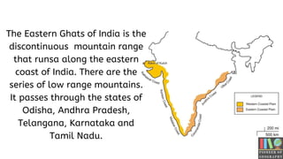
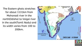
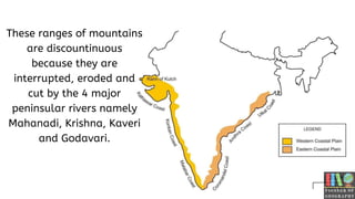
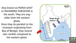
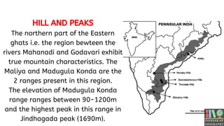
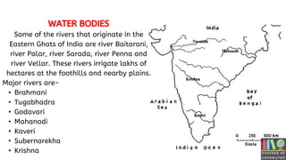
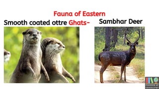
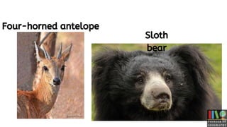
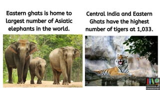
GEOGRAPHY
OF
The Eastern Ghats of India is the
discontinuous mountain range
that runsa along the eastern
coast of India. There are the
series of low range mountains.
It passes through the states of
Odisha, Andhra Pradesh,
Telangana, Karnataka and
Tamil Nadu.
The Eastern ghats stretches
for about 1131km from
Mahanadi river in the
north(Odisha) to Vaigai river
in the south(Tamil Nadu) and
its width varies from 100 to
200km.
These ranges of mountains
are discountinuous
because they are
interrupted, eroded and
cut by the 4 major
peninsular rivers namely
Mahanadi, Krishna, Kaveri
and Godavari.
Also known as PURVA GHAT
or MAHENDRA PARVATAM in
the south. They are way
older than the western
ghats.
Since they lie parallel to the
monsoon originating from
Bay of Bengal, they recieve
less rainfall compared to
the western ghats.
HILL AND PEAKS
The northern part of the Eastern
ghats i.e. the region bewteen the
rivers Mahanadi and Godavari exhibit
true mountain characteristics. The
Maliya and Madugula Konda are the
2 ranges present in this region.
The elevation of Madugula Konda
range ranges between 90-1200m
and the highest peak in this range in
Jindhagada peak (1690m).
WATER BODIES
Some of the rivers that originate in the
Eastern Ghats of India are river Baitarani,
river Palar, river Sarada, river Penna and
river Vellar. These rivers irrigate lakhs of
hectares at the foothills and nearby plains.
Major rivers are-
• Brahmani
• Tugabhadra
• Godavari
• Mahanadi
• Kaveri
• Subernarekha
• Krishna
Fauna of Eastern
Ghats-
Smooth coated ottre Sambhar Deer
Four-horned antelope
Sloth
bear
Eastern ghats is home to
largest number of Asiatic
elephants in the world.
Central India and Eastern
Ghats have the highest
number of tigers at 1,033.
THANKS FOR WATCHING

GEOGRAPHY OF EASTERN GHATS

  • 1.
  • 2.
    The Eastern Ghatsof India is the discontinuous mountain range that runsa along the eastern coast of India. There are the series of low range mountains. It passes through the states of Odisha, Andhra Pradesh, Telangana, Karnataka and Tamil Nadu.
  • 3.
    The Eastern ghatsstretches for about 1131km from Mahanadi river in the north(Odisha) to Vaigai river in the south(Tamil Nadu) and its width varies from 100 to 200km.
  • 4.
    These ranges ofmountains are discountinuous because they are interrupted, eroded and cut by the 4 major peninsular rivers namely Mahanadi, Krishna, Kaveri and Godavari.
  • 5.
    Also known asPURVA GHAT or MAHENDRA PARVATAM in the south. They are way older than the western ghats. Since they lie parallel to the monsoon originating from Bay of Bengal, they recieve less rainfall compared to the western ghats.
  • 6.
    HILL AND PEAKS Thenorthern part of the Eastern ghats i.e. the region bewteen the rivers Mahanadi and Godavari exhibit true mountain characteristics. The Maliya and Madugula Konda are the 2 ranges present in this region. The elevation of Madugula Konda range ranges between 90-1200m and the highest peak in this range in Jindhagada peak (1690m).
  • 7.
    WATER BODIES Some ofthe rivers that originate in the Eastern Ghats of India are river Baitarani, river Palar, river Sarada, river Penna and river Vellar. These rivers irrigate lakhs of hectares at the foothills and nearby plains. Major rivers are- • Brahmani • Tugabhadra • Godavari • Mahanadi • Kaveri • Subernarekha • Krishna
  • 8.
    Fauna of Eastern Ghats- Smoothcoated ottre Sambhar Deer
  • 9.
  • 10.
    Eastern ghats ishome to largest number of Asiatic elephants in the world. Central India and Eastern Ghats have the highest number of tigers at 1,033.
  • 11.