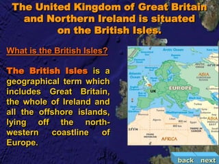
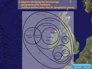
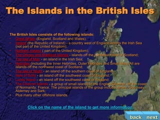
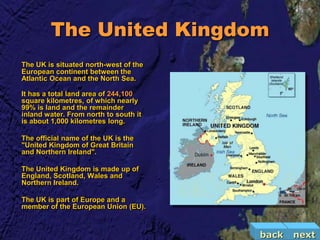
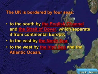
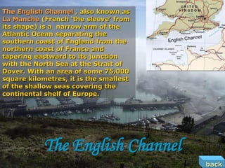
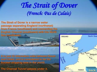
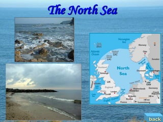
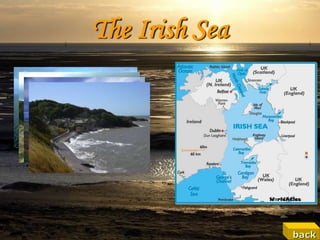
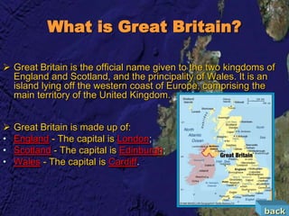
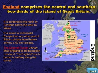
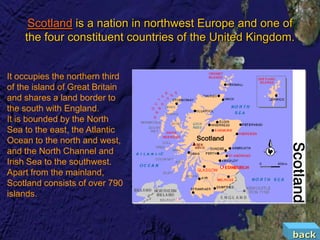
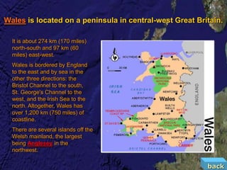
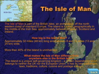
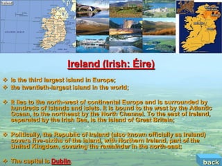
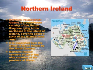
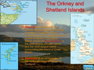
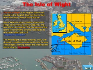
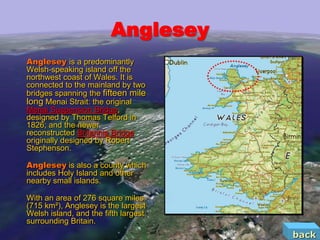
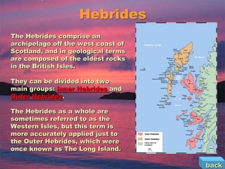
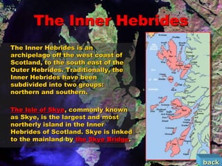
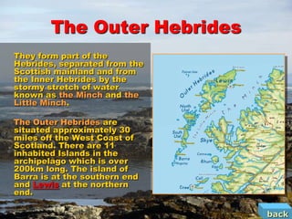
The United Kingdom is situated on the British Isles off the northwestern coast of Europe. It consists of England, Scotland, Wales, and Northern Ireland on the island of Great Britain along with over 1,000 smaller islands. The British Isles encompass the UK as well as the Republic of Ireland and surrounding islands. Major islands in the British Isles include Great Britain, Ireland, Isle of Man, Isle of Wight, Orkney Islands, Shetland Islands, and numerous others.
Hello people! This handout introduces us to the world of England literature in the 20th century. Included also in the handout is a sample literary piece which is The Secret Sharer by Joseph Conrad
Britain is fast becoming bigger and bigger on the map in terms of culture and technology.
Our little island is really making a name for itself around the world.
The French Revolution, which began in 1789, was a period of radical social and political upheaval in France. It marked the decline of absolute monarchies, the rise of secular and democratic republics, and the eventual rise of Napoleon Bonaparte. This revolutionary period is crucial in understanding the transition from feudalism to modernity in Europe.
For more information, visit-www.vavaclasses.com
How to Make a Field invisible in Odoo 17Celine George
It is possible to hide or invisible some fields in odoo. Commonly using “invisible” attribute in the field definition to invisible the fields. This slide will show how to make a field invisible in odoo 17.
Students, digital devices and success - Andreas Schleicher - 27 May 2024..pptxEduSkills OECD
Andreas Schleicher presents at the OECD webinar ‘Digital devices in schools: detrimental distraction or secret to success?’ on 27 May 2024. The presentation was based on findings from PISA 2022 results and the webinar helped launch the PISA in Focus ‘Managing screen time: How to protect and equip students against distraction’ https://www.oecd-ilibrary.org/education/managing-screen-time_7c225af4-en and the OECD Education Policy Perspective ‘Students, digital devices and success’ can be found here - https://oe.cd/il/5yV
The Roman Empire A Historical Colossus.pdfkaushalkr1407
The Roman Empire, a vast and enduring power, stands as one of history's most remarkable civilizations, leaving an indelible imprint on the world. It emerged from the Roman Republic, transitioning into an imperial powerhouse under the leadership of Augustus Caesar in 27 BCE. This transformation marked the beginning of an era defined by unprecedented territorial expansion, architectural marvels, and profound cultural influence.
The empire's roots lie in the city of Rome, founded, according to legend, by Romulus in 753 BCE. Over centuries, Rome evolved from a small settlement to a formidable republic, characterized by a complex political system with elected officials and checks on power. However, internal strife, class conflicts, and military ambitions paved the way for the end of the Republic. Julius Caesar’s dictatorship and subsequent assassination in 44 BCE created a power vacuum, leading to a civil war. Octavian, later Augustus, emerged victorious, heralding the Roman Empire’s birth.
Under Augustus, the empire experienced the Pax Romana, a 200-year period of relative peace and stability. Augustus reformed the military, established efficient administrative systems, and initiated grand construction projects. The empire's borders expanded, encompassing territories from Britain to Egypt and from Spain to the Euphrates. Roman legions, renowned for their discipline and engineering prowess, secured and maintained these vast territories, building roads, fortifications, and cities that facilitated control and integration.
The Roman Empire’s society was hierarchical, with a rigid class system. At the top were the patricians, wealthy elites who held significant political power. Below them were the plebeians, free citizens with limited political influence, and the vast numbers of slaves who formed the backbone of the economy. The family unit was central, governed by the paterfamilias, the male head who held absolute authority.
Culturally, the Romans were eclectic, absorbing and adapting elements from the civilizations they encountered, particularly the Greeks. Roman art, literature, and philosophy reflected this synthesis, creating a rich cultural tapestry. Latin, the Roman language, became the lingua franca of the Western world, influencing numerous modern languages.
Roman architecture and engineering achievements were monumental. They perfected the arch, vault, and dome, constructing enduring structures like the Colosseum, Pantheon, and aqueducts. These engineering marvels not only showcased Roman ingenuity but also served practical purposes, from public entertainment to water supply.
How to Split Bills in the Odoo 17 POS ModuleCeline George
Bills have a main role in point of sale procedure. It will help to track sales, handling payments and giving receipts to customers. Bill splitting also has an important role in POS. For example, If some friends come together for dinner and if they want to divide the bill then it is possible by POS bill splitting. This slide will show how to split bills in odoo 17 POS.
Unit 8 - Information and Communication Technology (Paper I).pdfThiyagu K
This slides describes the basic concepts of ICT, basics of Email, Emerging Technology and Digital Initiatives in Education. This presentations aligns with the UGC Paper I syllabus.
How to Create Map Views in the Odoo 17 ERPCeline George
The map views are useful for providing a geographical representation of data. They allow users to visualize and analyze the data in a more intuitive manner.
1. Click me to start
Geographical position
and
composition of the country
back
2. The United Kingdom of Great Britain
and Northern Ireland is situated
on the British Isles.
What is the British Isles?
The British Isles is a
geographical term which
includes Great Britain,
the whole of Ireland and
all the offshore islands,
lying off the north-
western coastline of
Europe.
back next
3. A diagram clarifying the terminology:
geographic-only locations;
political entities (may also be geographic terms).
back next
4. The Islands in the British Isles
The British Isles consists of the following islands:
• Great Britain (England, Scotland and Wales);
• Ireland (the Republic of Ireland) - a country west of England across the Irish Sea
(not part of the United Kingdom);
• Northern Ireland ( part of the United Kingdom);
• The Orkney and Shetland Islands - islands off the northeast coast of Scotland;
• The Isle of Man - an island in the Irish Sea;
• Hebrides (including the Inner Hebrides, Outer Hebrides and Small Isles) All are
islands off the northwest coast of Scotland;
• The Isle of Wight - an island off the southern coast of England;
• Isles of Scilly - an island off the southwest coast of England;
• Lundy Island - an island off the southwest coast of England;
• The Channel Islands - a group of small islands in the English Channel, off the coast
of Normandy, France. The principal islands of the group include Jersey, Guernsey,
Alderney and Sark;
• Plus many other offshore islands.
Click on the name of the island to get more information.
back next
5. The United Kingdom
The UK is situated north-west of the
European continent between the
Atlantic Ocean and the North Sea.
It has a total land area of 244,100
square kilometres, of which nearly
99% is land and the remainder
inland water. From north to south it
is about 1,000 kilometres long.
The official name of the UK is the
"United Kingdom of Great Britain
and Northern Ireland".
The United Kingdom is made up of
England, Scotland, Wales and
Northern Ireland.
The UK is part of Europe and a
member of the European Union (EU).
back next
6. The UK is bordered by four seas:
• to the south by the English Channel
and the Strait of Dover, which separate
it from continental Europe;
• to the east by the North Sea;
• to the west by the Irish Sea and the
Atlantic Ocean.
back home
7. The English Channel , also known as
La Manche (French ‘the sleeve’ from
its shape) is a narrow arm of the
Atlantic Ocean separating the
southern coast of England from the
northern coast of France and
tapering eastward to its junction
with the North Sea at the Strait of
Dover. With an area of some 75,000
square kilometres, it is the smallest
of the shallow seas covering the
continental shelf of Europe.
The English Channel
back
8. The Strait of Dover
(French: Pas de Calais)
The Strait of Dover is a narrow water
passage separating England (northwest)
from France (southeast) and connecting the
English Channel (southwest) with the North
Sea (northeast).
It is just 33 kilometers wide between Dover
and Calais, and is considered to be the
busiest shipping lane in the world.
The Channel Tunnel passes under it.
back
11. What is Great Britain?
Great Britain is the official name given to the two kingdoms of
England and Scotland, and the principality of Wales. It is an
island lying off the western coast of Europe, comprising the
main territory of the United Kingdom.
Great Britain is made up of:
• England - The capital is London;
• Scotland - The capital is Edinburgh;
• Wales - The capital is Cardiff.
back
12. England comprises the central and southern
two-thirds of the island of Great Britain.
It is bordered to the north by
Scotland and to the west by
Wales.
It is closer to continental
Europe than any other part of
Britain, divided from France
only by a 52 km sea gap.
The Channel Tunnel directly
links England to the European
mainland. The English/French
border is halfway along the
tunnel.
back
13. Scotland is a nation in northwest Europe and one of
the four constituent countries of the United Kingdom.
It occupies the northern third
of the island of Great Britain
and shares a land border to
the south with England.
It is bounded by the North
Sea to the east, the Atlantic
Ocean to the north and west,
and the North Channel and
Irish Sea to the southwest.
Apart from the mainland,
Scotland consists of over 790
islands.
back
14. Wales is located on a peninsula in central-west Great Britain.
It is about 274 km (170 miles)
north-south and 97 km (60
miles) east-west.
Wales is bordered by England
to the east and by sea in the
other three directions: the
Bristol Channel to the south,
St. George's Channel to the
west, and the Irish Sea to the
north. Altogether, Wales has
over 1,200 km (750 miles) of
coastline.
There are several islands off the
Welsh mainland, the largest
being Anglesey in the
northwest.
back
15. The Isle of Man
The Isle of Man is part of the British Isles, an archipelago off the north
western coast of mainland Europe. The island is located geographically in
the middle of the Irish Sea, approximately between England, Scotland and
Ireland.
How big is the Isle of Man?
Approximately 32 miles (48 km) long and between 8 and 15 miles (13 and
24 km) wide.
More than 40% of the Island is uninhabited.
What makes the Isle of Man different from
anywhere else in the British Isles?
The Island is a unique self-governing kingdom - a Crown dependency which
belongs to neither the UK nor the European Union. It has its own parliament,
laws, traditions, culture, cuisine and postage stamps.
back
16. Ireland (Irish: Éire)
is the third largest island in Europe;
the twentieth-largest island in the world;
It lies to the north-west of continental Europe and is surrounded by
hundreds of islands and islets. It is bound to the west by the Atlantic
Ocean, to the northeast by the North Channel. To the east of Ireland,
separated by the Irish Sea, is the island of Great Britain;
Politically, the Republic of Ireland (also known officially as Ireland)
covers five-sixths of the island, with Northern Ireland, part of the
United Kingdom, covering the remainder in the north-east;
The capital is Dublin. back
17. Northern Ireland
Northern Ireland (Irish:
Ulster) is a constituent
country of the United
Kingdom, lying in the
northeast of the island of
Ireland, covering about a
sixth of the island's total
area.
It is separated from the
island of Great Britain by
the North Channel.
Northern Ireland
consists of six of the
nine counties of the
province of Ulster.
back
18. The Orkney and
Shetland Islands
Orkney (also known as the
Orkney Islands) is an island group
in northern Scotland. Orkney
comprises over 70 islands; around
20 are inhabited. The largest
island, known as “the Mainland” is
the sixth-largest Scottish island
and the ninth-largest island
surrounding the island of Great
Britain.
Shetland is an archipelago off
the northeast coast of mainland
Scotland.
back
19. The Isle of Wight
The Isle of Wight is an English island and
county in the English Channel three miles
from the south coast of Great Britain.
Isle of Wight is approximately diamond in
shape and covers an area of 380 km². and
has 92 km of coastline. The landscape of the
Island is remarkably diverse, leading to its
oft-quoted description of
"England in Miniature".
The West Wight is predominantly rural, with
dramatic coastlines dominated by the famous
chalk ridges, running across the whole Island
and ending in The Needles.
back
20. The Needles
a row of three distinctive stacks of chalk that rise out of the sea off the western
coast. A lighthouse designed by Scottish civil engineer James Walker has stood
at the western end of the formation since 1859.
back
21. The Channel Tunnel
Location: Beneath the English Channel
(Strait of Dover);
Status: Active;
Start: Folkestone, Kent, England;
End: Coquelles, Pas-de-Calais, France;
Opened: 6 May 1994;
Description: The tunnel consists of three
parallel tunnels. There are two rail tunnels,
which carry trains north-west and south-east.
Between the rail tunnels there is a service
tunnel served by narrow rubber-tyred vehicles.
It gives maintenance workers access to the
rail tunnels and provides a route for escape
during emergencies;
Statistics: The Channel Tunnel is 50.450 km
long, of which 37.9 km are undersea. The
average depth is 45.7 m underneath the
seabed, and the deepest is 60 m. The
undersea section, at 37.9 km, is the longest
undersea tunnel in the world.
back
23. Anglesey
Anglesey is a predominantly
Welsh-speaking island off the
northwest coast of Wales. It is
connected to the mainland by two
bridges spanning the fifteen mile
long Menai Strait: the original
Menai Suspension Bridge,
designed by Thomas Telford in
1826; and the newer
reconstructed Britannia Bridge
originally designed by Robert
Stephenson.
Anglesey is also a county which
includes Holy Island and other
nearby small islands.
With an area of 276 square miles
(715 km²), Anglesey is the largest
Welsh island, and the fifth largest
surrounding Britain.
back
25. Menai Suspension Bridge
The Menai Suspension Bridge is a suspension bridge between the island
of Anglesey and the mainland of Wales.
Designed by Thomas Telford and completed in 1826, it is one of the first
modern suspension bridges in the world.
back
26. Britannia Bridge
Britannia Bridge is a bridge across the Menai Strait between the
island of Anglesey and the mainland of Wales, originally a tubular
bridge, and now a two level steel truss arch bridge carrying both
trains and road traffic.
The present day bridge has a much different appearance than the
original. This is because it has been reconstructed after a
disastrous fire in 1970. A group of teenagers looking for bats in the
dark tubes accidentally dropped the burning paper they were using
as a torch. This eventually started a fire through the whole tubular
structure that caused much damage to the tubes.
back
27. Hebrides
The Hebrides comprise an
archipelago off the west coast of
Scotland, and in geological terms
are composed of the oldest rocks
in the British Isles.
They can be divided into two
main groups: Inner Hebrides and
Outer Hebrides.
The Hebrides as a whole are
sometimes referred to as the
Western Isles, but this term is
more accurately applied just to
the Outer Hebrides, which were
once known as The Long Island.
back
28. The Inner Hebrides
The Inner Hebrides is an
archipelago off the west coast of
Scotland, to the south east of the
Outer Hebrides. Traditionally, the
Inner Hebrides have been
subdivided into two groups:
northern and southern.
The Isle of Skye, commonly known
as Skye, is the largest and most
northerly island in the Inner
Hebrides of Scotland. Skye is linked
to the mainland by the Skye Bridge.
back
29. The Outer Hebrides
They form part of the
Hebrides, separated from the
Scottish mainland and from
the Inner Hebrides by the
stormy stretch of water
known as the Minch and the
Little Minch.
The Outer Hebrides are
situated approximately 30
miles off the West Coast of
Scotland. There are 11
inhabited Islands in the
archipelago which is over
200km long. The island of
Barra is at the southern end
and Lewis at the northern
end.
back
30. Lewis and Harris
Lewis and Harris in the
Outer Hebrides make up the
largest island in Scotland. It
has an area of 841 square
miles (2,180 km²) - slightly
under one per cent of the
area of Great Britain.
The northern part of the
island is called Lewis, the
southern is Harris and both
are frequently referred to as Callanish stone circle
if they were separate
islands.
Lewis was first settled in
the Iron Age - people who
left their mark in the
countless Neolithic sites
which scatter the island.
back
33. London
London /lʌndən/ is the
capital and largest
urban area of England
and the United
Kingdom.
back
34. Edinburgh
Edinburgh /ɛdɪnb(ə)rə/ is
the capital of Scotland,
the seventh-largest city in
the United Kingdom.
back
35. Cardiff
Cardiff is the capital
and largest city of Wales.
location of the city of Cardiff (light green)
within the Principality of Wales (dark
green)
back
36. Belfast
Belfast (from the Irish: meaning "Sandy ford at
river mouth") is the capital of Northern Ireland. It
is the largest urban area in Northern Ireland and
the province of Ulster and the second-largest
city on the island of Ireland.
back
37. Dublin
Dublin /dʌblɨn/ (meaning Town of the
Hurdled Ford) is both the largest city and
the capital of Ireland.
It is located near the midpoint of Ireland's
east coast, at the mouth of the River
Liffey and at the centre of the Dublin
Region.
It is an economic, administrative and
cultural centre for the island of Ireland.
back