Gallagher Ltd was contracted to construct a new site entrance for Mercers South Quarry in Betchworth, Surrey. To complete the project, Gallagher used 17 Leica Captivate one person kits and a GNSS unit to ensure accurate measurement of the site and existing utility locations. The Leica equipment helped Gallagher design the new entrance alignment while avoiding utilities and minimizing environmental impact. The project was completed on time, resulting in a fully functioning quarry providing opportunities to the local community.
The engineer team defined the requirements, design, and installation guidelines for a safety system. All this associated with the setup of a Safety PLC with AMEC (Alternative Methods of Energy Control).
Gerrit Code Review is getting cloud-native, thanks to the extensions and plugins developed by GerritForge.
See how you can deploy and integrate Gerrit with AWS and GCloud and get the best of the serverless architecture, avoiding common pitfalls.
Last year we presented the vision and road-map of Gerrit multi-master setup at GerritHub.io. This year GerritForge and the Gerrit community have released the first version of the multi-site plugin, based on the legacy of the successful high-availability plugin started years ago by Ericsson.
The multi-site plugin is a 100% OpenSource solution and does not require any proprietary software installed or hardware/software level filesystem replication: it is fully based on the replication, healthcheck and multi-site plugins.
Multi-site is a journey and the Community is making big steps towards it.
Gerrit 3.0 it out! If you‘ve tried 2.16, you may have already seen the new database backend (NoteDb) and UI (PolyGerrit). With 2.16 and 3.0, these features are better than ever. In Gerrit 3.0, we’ve deleted thousands and thousands of lines from Gerrit's codebase.
Join me for a tour of new features you can use today, and a discussion about even more things to look forward to once we've freed ourselves from the burden of some of our legacy code.
The engineer team defined the requirements, design, and installation guidelines for a safety system. All this associated with the setup of a Safety PLC with AMEC (Alternative Methods of Energy Control).
Process gas chromatograph for industrial process measurementArjay Automation
The GC8000 has a built-in 12-inch color touchscreen display that dramatically simplifies maintenance. At the touch of the screen, the technician can access all of the analytical parameters and measurement results; displayed in easy-to-understand graphical color screens.
The GC8000 also brings a number of important innovations in its gas chromatograph analytical capabilities. For the first time, parallel chromatography is made practical with the introduction of the GC Module (GCM) concept. By setting up virtual GCs within a single analyzer, all chromatograph settings, displays, and data are truly segregated for easy understanding and maintenance. There are even built-in graphical overview screens showing each of the individual GC Modules.
Yokogawa has a long history of supplying process gas chromatographs to the oil & gas, refining and petrochemical industries around the world. The new process GC that meets the ever growing demands for analytical reliability and precision while improving the total cost-of ownership through built-in automated maintenance functions never seen before.
From the innovative 12-inch color touch screen HMI to the powerful predictive diagnostics, the GC8000 is truly a process GC for the 21st century. But the GC8000 is not just all about new electronics; it also brings a number of important innovations in gas chromatograph analytical capabilities. For the first time, parallel chromatography is made practical with the introduction of the GC Module (GCM) concept. By setting up virtual GCs within a single analyzer, all chromatograph settings, displays, and data are truly segregated for easy understanding and maintenance. There are even built-in graphical overview screens showing each of the individual GC Modules.
The GC8000 sets new standards for process gas chromatography while at the same time offering hardware and electronics that are recognized for robust and reliable operation.
Yokogawa has a long history of supplying process gas chromatographs to the oil & gas, refining and petrochemical industries around the world. The GC8000 process GC meets ever growing demands for analytical reliability and precision while improving the total cost-of ownership with unique built-in automated maintenance functions. The 12-inch color touch screen HMI and powerful predictive diagnostics make the GC8000 a process GC for 21st century applications. The GC8000, in addition to its new electronics, brings a number of important innovations in gas chromatograph analytical capabilities. For the first time, parallel chromatography is made practical with the introduction of the GC Module (GCM) concept. By setting up virtual GCs within a single analyzer, all chromatograph settings, displays, and data are truly segregated for easy understanding and maintenance. There are even built-in graphical overview screens showing each of the individual GC Modules.
OGC Update for State of Geospatial Tech at T-RexGeorge Percivall
An update on OGC activities in three time horizons: Now, Next and After Next. Finishing with how to keep updated on OGC activities.
Now
Recently approved OGC standards
Implementation of approved standards
Next
Standards Program
Innovation Program
After Next
Tech Forecast
How to keep in touch
Le Bourget 2017 - From earth observation to actionable intelligenceLeonardo
During the 2017 edition of the Paris Air Show, Luigi Pasquali, Director of Leonardo Space sector talked how Earth Observation can helo actionable intelligence through the study of Big-data
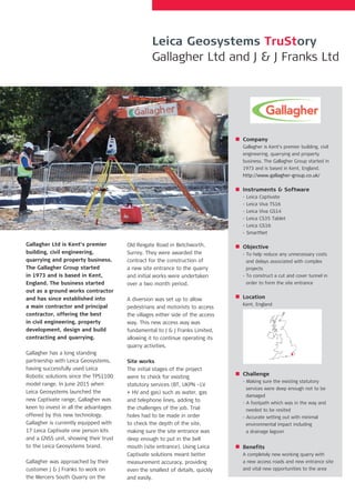
1. Gallagher Ltd is Kent’s premier
building, civil engineering,
quarrying and property business.
The Gallagher Group started
in 1973 and is based in Kent,
England. The business started
out as a ground works contractor
and has since established into
a main contractor and principal
contractor, offering the best
in civil engineering, property
development, design and build
contracting and quarrying.
Gallagher has a long standing
partnership with Leica Geosystems,
having successfully used Leica
Robotic solutions since the TPS1100
model range. In June 2015 when
Leica Geosystems launched the
new Captivate range, Gallagher was
keen to invest in all the advantages
offered by this new technology.
Gallagher is currently equipped with
17 Leica Captivate one person kits
and a GNSS unit, showing their trust
to the Leica Geosystems brand.
Gallagher was approached by their
customer J & J Franks to work on
the Mercers South Quarry on the
Old Reigate Road in Betchworth,
Surrey. They were awarded the
contract for the construction of
a new site entrance to the quarry
and initial works were undertaken
over a two month period.
A diversion was set up to allow
pedestrians and motorists to access
the villages either side of the access
way. This new access way was
fundamental to J & J Franks Limited,
allowing it to continue operating its
quarry activities.
Site works
The initial stages of the project
were to check for existing
statutory services (BT, UKPN –LV
+ HV and gas) such as water, gas
and telephone lines, adding to
the challenges of the job. Trial
holes had to be made in order
to check the depth of the site,
making sure the site entrance was
deep enough to put in the bell
mouth (site entrance). Using Leica
Captivate solutions meant better
measurement accuracy, providing
even the smallest of details, quickly
and easily.
Company
Gallagher is Kent’s premier building, civil
engineering, quarrying and property
business. The Gallagher Group started in
1973 and is based in Kent, England.
http://www.gallagher-group.co.uk/
Instruments & Software
- Leica Captivate
- Leica Viva TS16
- Leica Viva GS14
- Leica CS35 Tablet
- Leica GS16
- SmartNet
Objective
- To help reduce any unnecessary costs
and delays associated with complex
projects
- To construct a cut and cover tunnel in
order to form the site entrance
Location
Kent, England
Challenge
- Making sure the existing statutory
services were deep enough not to be
damaged
- A footpath which was in the way and
needed to be resited
- Accurate setting out with minimal
environmental impact including
a drainage lagoon
Benefits
A completely new working quarry with
a new access roads and new entrance site
and vital new opportunities to the area
Leica Geosystems TruStory
Gallagher Ltd and J & J Franks Ltd