
Recommended
Recommended
More Related Content
Similar to Evolving Environmental change related to landscape.pptx
Similar to Evolving Environmental change related to landscape.pptx (20)
Recently uploaded
Recently uploaded (20)
Evolving Environmental change related to landscape.pptx
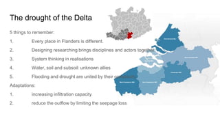
- 1. The drought of the Delta 5 things to remember: 1. Every place in Flanders is different. 2. Designing researching brings disciplines and actors together. 3. System thinking in realisations 4. Water, soil and subsoil: unknown allies 5. Flooding and drought are united by their complexity Adaptations: 1. increasing infiltration capacity 2. reduce the outflow by limiting the seepage loss
- 2. Strategy for The ‘Kempen’ - Testing ground for circular and area- specific agriculture. - “Nature based solutions” as starting point for system recovery
- 3. Forest dieback in the „Harz“ Reasons:
- 4. Forest dieback in the „Harz“
- 5. Image via the European Environment Agency. INVERSION WEATHER (STUTTGART) warm air layers lie above colder layers https://tse2.mm.bing.net/th?id=OIP.-BkrnPvhFqMMjd5LgHQfpwHaFe&pid=Api pollutants do not get removed: poor air quality health risks
- 6. Measures: - Fresh air corridors - keep and crosslink green spaces - “Feinstaubalarm”: less motorized individual transport (free/ cheaper public transport) - focus on public transport - structural measures INVERSION WEATHER (STUTTGART) https://www.stuttgarter-nachrichten.de/media.media.f83103c4-df73-4e23-9271- f8e57b8a311f.original1024.jpg https://tse4.mm.bing.net/th?id=OIP.ML0QPcvx9rF_pDPbH800SgAAAA&pid=Api
- 9. WHAT IS IT? An alternative to the traditional road infrastructure building. Based on the Ecosystem - Culture Model and included in the ONU 2030 Goals of sustainable development. Adaptation to the natural environment, without exceeding their ecosystem limits. Vital spaces of integration of social and environmental potential. CURRENT CONDITIONS: ● Landscape value PCC (Unesco Patrimony site) ● Poor connectivity due to geographical factors. ● Capital city (Manizales) located between the 3 main cities of the country. ● Population of the department: 1’008.344 ● Area: 788 km2 ● Andean Tropics ecosystem diversity: 13 river basins and altitudes between 500 - 5321 masl. BIORUTA TRANSVERSAL DE CALDAS BIBLIOGRAPHY: Instituto de Estudios Ambientales -IDEA- Sede Manizales. (2022). Bio-Ruta Transversal de Caldas una alternativade movilidadsostenible. De Vía a Bío entre los ríos Magdalena y Cauca del trópico andino en Colombia. Boletín Ambiental, 190.
- 10. PROJECT: ● 300 meters reforestation strip alongside the 150km of the road. ● Double vehicular roads, 1 railway, service ducts. ● Independent bike and motorcycle roads. ● No aesthetic affectation of the natural and cultural landscapes. ● Optimization of costs and resources by Public-Private alliances. ● Identification of Ecosystems and their susceptibility. ● Characterization of the affected population and their structural dynamics. ● Articulation of Ruta del Sol and Pacifico 3 with the ports in the Pacific ocean and the airports at the country’s interior. ● Inclusion of Fauna bridges and ecoduct. ● Biological corridor that connects ecosystems of altitudes between 530 and 2500 masl. ● Complementary spaces such as hiking trails, sightseeing points and touristic infrastructure. OBJECTIVES: ● Connect the river basins of the Cauca and Magdalena rivers (the two most important rivers in Colombia) ● Crossing the Central Mountain range and connect most towns and cities in the East of the department. Including Manizales and La Dorada (the two biggest cities) ● Enhance development engines of green infrastructure, commerce logistics, agro industries, tourism and communication. ● Lower the production, transportation costs and the fuel consumption. ● Reducing travel times from all the cities of the department to the capital to 2 hours or less. TAKEN FROM: https://www.eje21.com.co/2022/01/gobierno-de-caldas-dio-luz-verde-a-bio-ruta- transversal/
- 11. The Murray Darling Basin •Australia’s largest river system, purpose was to stop too much water taken out of rivers, for wetlands, waterbirds and fish to survive •Covers about a seventh of the Australian land mass – across 5 states and territories •Vast amounts of water are extracted from the rivers to supply around 3 million Australians, including irrigating farms •Millenium drought + increased water needs resulted in damage to this system •The Basin Plan was developed in response the damage, and to climate change
- 12. Climate change mitigation strategies •The water authority uses a method called adaptive management – involves experimenting, monitoring, and adjusting as needed. Allows for flexibility and dynamic decision making •Basin Plan provides a framework for water management to adapt to the challenge of a changing climate. Formal 10 year review •The climate of the basin is changing, the environment will need to adapt to a hotter and drier climate future •Australian govt has invested $20 million into a research program, in recognition of more research needed •Water buybacks from farmers – govt taking water from the river system from people who want to sell them, to ensure river environments for the plants and animals that need it most •Remove obsolete and wasteful plans – questionable water saving projects •Focus on reconnecting rivers to their floodplains – must be regularly inundated with water (managed “flooding”, reducing impacts of natural flooding disasters)
- 13. “Iran plans to pump water via a 200km pipeline from the Caspian Sea to Semnan province” Iran is located in arid and semi-arid areas
- 14. Farmer Strategies for Mitigation and Adaptation to Climate Change in Calpan, Puebla, Mexico 2020, Postgraduate College, Campus Puebla 1970 – 2011 69.7% of the disasters that occurred were caused by hydrometeorological events 55% floods 33% storms and hurricanes 10% droughts 2% extreme temperatures (FAO 2018) Calpan, Puebla 67 km² 13,730 inhabitants 52% women - 47% men Rainfed agriculture Maiz: 73% cultivated area (INEGI 2015) Google Maps Google Maps
- 15. DIVERSI FICATION ANIMAL POWER MAIZ MANAGE MENT SOIL CONSER VATION corpenca.org elciudadano.com desdelverdun.org pinterest ehow.com rosbesan
- 16. REFERENCES Colegio de Postgraduados, Campus Puebla. 2020. Estrategias campesinas de mitigación y adaptabilidad al cambio climático en Calpan, Puebla, México. Reflexiones de Género. FAO (Organización de las Naciones Unidas para la Alimentación y la Agricultura). 2018. Cambio climático y seguridad alimentaria y nutricional América Latina y el Caribe. Santiago de Chile: FAO. INEGI (Instituto Nacional de Estadística, Geografía e Informática). 2015. Cartografía del estado de Puebla-México. http://internet.contenidos.inegi.org.mx/contenidos/productos/prod_serv/contenidos/espanol/bvinegi/productos/nueva_estruc /anuarios_2015/702825077129.pdf
- 17. Palmas, Tocantins, Brazil Planned capital 306.296 inhabitants Planned occupation phases Perspective sketch Historical evolution of Palmas expansion Satellite image (2021) Location of the plazas implemented superimposed on the income map on the left, and on the density map, on the right.
- 18. Urban sprawl Segregation of leisure and green spaces Social housing areas Urban land speculation Gated communities Land regularization Mobility infrastructure Hot and dry weather - 40 °C Insufficient or inadequate trees Monotonous landscape Safety ● Challenges ● Potentialities Enough space for urban transformations Renewable energy Many conservation units Open spaces connection Touristic access to Jalapão Keywords chosen by 60 people interviewed "The city is very hot and yet there doesn't seem to have been any pedestrian-oriented planning to combat this, on the contrary, in fact, the city seems to have mounted a crusade against trees and areas on pedestrian routes. Where there are benches there's no tree, where there's a tree there's no path, where there's a ramp there's no crosswalk, and where there's a crosswalk there's no ramp." Man, 19-29, Palmas 1 2 3 4 5
Editor's Notes
- Source: https://www.vlaamsbouwmeester.be/sites/default/files/uploads/DDD_Kleine%20Nete_final_web.pdf
- https://theconversation.com/with-less-than-a-year-to-go-the-murray-darling-basin-plan-is-in-a-dreadful-mess-these-5-steps-are-needed-to-fix-it-209328 https://www.mdba.gov.au/climate-and-river-health/climate/our-climate-workplan https://www.mdba.gov.au/basin/why-murray-darling-basin-matters
- https://storymaps.arcgis.com/stories/39ef70f06b81451a940491bb5e57dec8 https://environmentvictoria.org.au/2023/09/10/we-cant-save-the-murray-darling-without-water-buybacks-heres-what-you-need-to-know/