Downloaded 17 times


![160
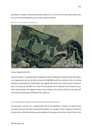
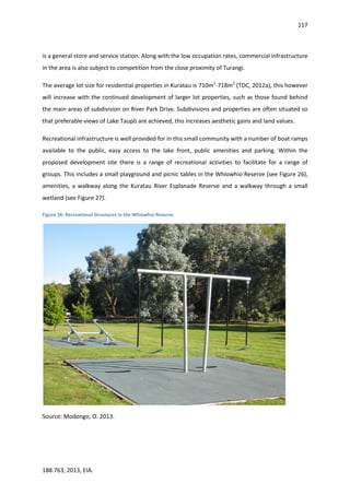
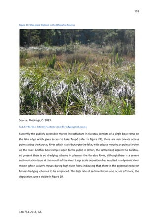
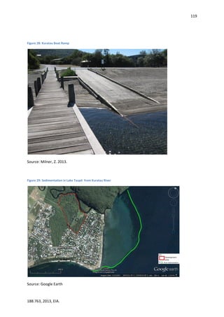
188.763, 2013, EIA.
Gaiser, E., Richards, J., Trxler, J., Jones, R., & Childers, D. (2006). Periphyton responses to
eutrophication in the Florida Everglades: cross-system patterns of structural and
compositional change. Limnology and Oceanography, 51(1), 617-630.
Gisborne District Council. 2009. Proposed regional coastal environment plan.
Glasson, J., Therivel, R., & Chadwick, A. (2005). Introduction to Environmental Impact Assessment.
(3rd
ed.). New York: Routledge.
Goodman, J. (2012). Submission Form [Submission on Proposed Southern Settlements Structure
Plan]. Retrieved from http://www.Taupōdc.govt.nz/our-council/policies- plans-and-
bylaws/structure-plans/southern-settlements-structure-plan/Pages/
southern-settlements-structure-plan.aspx.
Google. (26th
Feb 2013). Google Earth [Program], Version 7.0.3.8542.
Hanna, K. (2005). A brief introduction to environmental impact assessment. In Hanna, K. S.
(ed.). Environmental Impact Assessment: Practice and Participation (3-15). Ontario,
Canada: Oxford University Press.
Hoadley, R. (2013). Comment [Submission on Proposed Southern Settlements Structure Plan].
Retrieved from http://www.Taupōdc.govt.nz/our-council/policies-plans-and-bylaws/
structure-plans/southern-settlements-structure-plan/Pages/southern-settlements-
structure-plan.aspx.
Iannuzzi, T., Weinstein, M., Sellner, K., & Barret, J. (1996). Habitat disturbance and marina
development: an assessment of ecological effects: changes in primary production due to
dredging and marina construction. Coastal and Estuarine Federation, 19(2), 257-271.
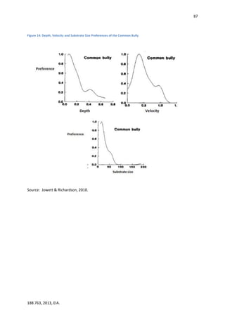
Jowett, J. & Richardson, J. (2008). Where do Fish Want to Live? Water & Atmosphere, 16(3), 12-13.
Jowett, I. & Richardson, J. (2010). Habitat preferences of common riverine New Zealand native
fishes and implications for flow management. New Zealand Journal of Marine and
Freshwater Research, 29(1), 13-23.
Joy, M., David, B., Lake, M. (2013). New Zealand Freshwater Fish Sampling Protocols: Wadeable
Rivers and Streams. Massey University: Palmerston North.
King Country Energy Limited. (n.d.). Kuratau Power Station [Factsheet]. Retrieved from
http://www.kce.co.nz/wp-content/uploads/Kuratau.pdf.
King Country Energy Limited. (2000). Kuratau Power Scheme: Resource Consent Applications and
Assessment of Effects on the Environment [Resource Consent Application], Volume Two
(Draft). New Zealand: Author.
King Country Energy Limited. (2013). Re: Submission on the Proposed Southern Settlement
Structure Plan [Submission on Proposed Southern Settlements Structure Plan]. Retrieved
from http://www.Taupōdc.govt.nz/our-council/policies-plans-and-bylaws/
structure-plans/southern-settlements-structure-plan/Pages/southern-settlements-
structure-plan.aspx.
Knight, R.L. (1992). Ancillary benefits and potential problems with the use of wetlands for nonpoint](https://image.slidesharecdn.com/eaa0df4b-347e-43e8-b498-a43ef1dd3d8d-150710002958-lva1-app6892/85/EIA-FINAL-160-320.jpg)
![161
188.763, 2013, EIA.
source pollution control. Ecological Engineering, 1, (1-2): 97-113.
Kuratau Omori Preservation Society. (2013). Submission of the Kuratau Omori Preservation
Society Inc. [Submission on Proposed Southern Settlements Structure Plan]. Retrieved
from http://www.Taupōdc.govt.nz/our-council/policies-plans-and-bylaws/structure-
plans/southern-settlements-structure-plan/Pages/southern-settlements-structure-
plan.aspx.
La Follette, C. & Thomas, R. (2013). The Nehalem Dredging Saga (article), In Tillamook Headlight
Herald. Retrieved from http://www.tillamookheadlightherald.com/news/article_3f1c5766-
a15c-11e2-b8dc-0019bb2963f4.html on 11/04/2013.
Landcare Research (n.d). S-Maps Online. Retrieved from http://smap.landcareresearch.co.nz.
Landcare Research (2013a). S-Map Soil Report: N_250_2.1. Retrieved From http://smap.
landcareresearch.co.nz..
Landcare Research (2013b). S-Map Soil Report: Taup_27.1. Retrieved From http://smap.
landcareresearch.co.nz..
Lewis, J. & Lewis, R. (2013). Written Submission [Submission on Proposed Southern Settlements
Structure Plan]. Retrieved from http://www.Taupōdc.govt.nz/our-council/
policies-plans-and-bylaws/structure-plans/southern-settlements-structure-
plan/Pages/southern-settlements-structure-plan.aspx.
Lowrance, R., Todd, R., Fail, J., Hendrickson, O., Leonard, R. & Asmussen, L. (1984). Riparian Forests
as Nutrient Filters in Agriculture Watersheds. Bioscience. 34(6), 374-377.
Matthaei, C., Weller, F., Kelly, D., & Townsend, C. (2006). Impacts of fine sediment addition to
tussock, pasture, dairy and deer farming streams in New Zealand. Freshwater Biology,
51(11), 2154-2172.
McKinlay, B. & Smale, A. (2001). The effect of jetboat wake on braided riverbed birds on the
Dart River. Notornis, 48, 72-75.
Mighty River Power, (2013). Lake Levels- Lake Taupō. Retrieved from
www.mightyriver.co.nz/Our-Buisness/Generation/Lake-Levels.aspx last updated April 2013
Ministry for Agriculture, Forestry and Fishing (Biosecurity). (2008). National Pest Plant Accord.
Retrieved from www.biosecurity.govt.nz/mppa.
Ministry for the Environment. (2006). Identifying, Investigating, and Managing Risks Associated
with Former Sheep-dip Sites: a Guide for Local Authorities. Wellington: Author.
Moore, T., & Hunt, W. (2012). Ecosystem service provision by stormwater wetlands and ponds: a
means for evaluation? Water Research, 6811-6823.
Nassauer, J., Allan, J., Johengen, T., Kosek, S., & Infante, D. (2004). Exurban residential subdivision
development: effects on water quality and public perception. Urban Ecosystems, 7(3),
267-281.](https://image.slidesharecdn.com/eaa0df4b-347e-43e8-b498-a43ef1dd3d8d-150710002958-lva1-app6892/85/EIA-FINAL-161-320.jpg)
![162
188.763, 2013, EIA.
National Instituted for Water and Atmosphere. (1997). Kuratau River Instream Habitat
Requirements [Client Report]. KCE70202: Author.
Oschwald, W. (1972). Sediment-water interactions. Journal of Environmental Quality, 1(4),
360-366.
Resource Management Act, No. 69. (1991). Retrieved from http://www.legislation.govt.nz.
Resource Management Regulations: National Environmental Standards for Air Quality, No. 309.
(2004). Retrieved from http://www.legislation.govt.nz.
Resource Management Regulations: National Environmental Standards for Assessing and
Managing Contaminants in Soil to Protect Human Health, No. 361. (2011). Retrieved
from http://www.legislation.govt.nz.
Resource Management Regulations: National Environment Standards for Electricity
Transmission Activities, No. 397. (2009). Retrieved from http://www.legislation.govt.nz.
Reynoldson, T., Metcalfe-Smith, J. (1992). An overview of the assessment of aquatic ecosystem
health using benthic invertebrates. Journal of Aquatic Ecosystem Health, 1(4), 295-
308.
Richards, S. (2012). Comment [Submission on Proposed Southern Settlements Structure Plan].
Retrieved from http://www.Taupōdc.govt.nz/our-council/policies-plans-and-bylaws/
structure-plans/southern-settlements-structure-plan/Pages/southern-settlements-
structure-plan.aspx.
Statistics New Zealand. (2006). Census. Retrieved from http://www.statsnz.govt.nz.
Taranaki Regional Council. (2009). A Photographic Guide to Freshwater Invertebrates of Taranaki’s
Rivers and Streams. Taranaki: Author.
Taupō District Council. (1990). Reserves and Development Incentives. Retrieved from http://
www.Taupōdc.govt.nz/our-council/policies-plans-and-bylaws/policies/Documents/
Reserve-And-Development-Incentives-1990.pdf.
Taupō District Council. (2006). Taupō District 2050: District Growth Management Strategy.
Retrieved from http://www.Taupōdc.govt.nz/our-council/policies-plans-and-bylaws/
district-strategies/td2050-growth-management-strategy/Pages/default.aspx .
Taupō District Council. (2007). Taupō District Plan. Retrieved from http://www.Taupōdc.govt.
nz/our-council/policies-plans-and-bylaws/district-plans/current-version/Pages/
current-version.aspx.
Taupō District Council. (2009). Code of Practice for Development of Land. Retrieved from
http://www.Taupōdc.govt.nz/our-council/policies-plans-and-bylaws/policies/
Documents/Code-of-Practice-Development-of-land-2009.pdf.
Taupō District Council. (2012a). Proposed Southern Settlements Structure Plan. Retrieved
from http://www.Taupōdc.govt.nz/our-council/policies-plans-and-bylaws/structure-
plans/southern-settlements-structure-plan/Documents/Proposed-Southern-
Settlements-Structure-Plan.pdf.](https://image.slidesharecdn.com/eaa0df4b-347e-43e8-b498-a43ef1dd3d8d-150710002958-lva1-app6892/85/EIA-FINAL-162-320.jpg)
![163
188.763, 2013, EIA.
Taupō District Council. (2012b). Maps for Our District. Retrieved From http://apps.geocirrus.
co.nz/?Viewer=TaupōDC.
Taupō District Council. (2012c). Development Contributions Policy. Retrieved from http://www.
Taupōdc.govt.nz/our-council/policies-plans-and-bylaws/policies/Documents/
Development-Contribution-policy-2012.pdf.
Taupō District Council. (2012d). Design Guide for Rural Subdivision: Amenity and Character.
Retrieved from http://www.Taupōdc.govt.nz/our-council/policies-plans-and-bylaws/
policies/Documents/Design-Guide-for-Rural-Subdivision.pdf.
Taupō District Council (TDC), (2012e) Rubbish and Recycling Retrieved from
http://www.Taupōdc.govt.nz/our-services/rubbish-and-recycling/Pages/default.aspx
Taupō District Council (TDC), (2012f). - Wastewater Asset Management Plan: Chapter 6 Future
Demand,, July 2012. Taupō District Council.
TradeMe. (2013, April 9). Marina Berths. Retrieved April 9, 2013, from TradeMe:
http://www.trademe.co.nz/motors/boats-marine/marina-berths
Tromans, D. (1998). Temperature and pressure dependent solubility of oxygen in water: a
thermodynamic analysis. Hydrometallurgy, 48(3), 327-342.
Trustees of Pukawa. (2013). Submission on Proposed Southern Settlements Structure Plan
[Submission on Proposed Southern Settlements Structure Plan]. Retrieved from
http://www.Taupōdc.govt.nz/our-council/policies-plans-and-bylaws/structure-plans/
southern-settlements-structure-plan/Pages/southern-settlements-structure-plan.aspx.
(USEPA. (2006). Stormwater Menu of BMPs. Retrieved 04 10, 2013, from United States
Envrionmental Protection Agency:
http://cfpub.epa.gov/npdes/stormwater/menuofbmps/index.cfm?action=browse&Rbutton=
detail&bmp=39
Venture Taranaki (2007). Port Taranaki Eastern Harbour Development Costs. Accessed from
https://docs.google.com/viewer?a=v&q=cache:3nh7LJ2FS9UJ:www.taranaki.info/admin/dat
a/business/marina_development.pdf+&hl=en&gl=nz&pid=bl&srcid=ADGEEShFU93gIN_I2ZJA
jjEzjZ31N0lQWA4dFP7cKCVRwfnaZ88JQ9DasQ38Y6yujLe_JMxYjR-
YxUNZFDEdpypJGEXP3VuRo4AERvmk5oV_BUZmsO7VL1BNLIrffCp9HbPxBPNkPF6E&sig=AHIE
tbTaRLu1wg6fX8-TIflpMacawgxhzg on 11/04/2013.
Waikato Regional Council. (2012a). Land and Soil Module. Retrieved from http://www.
waikatoregion.govt.nz/PageFiles/20874/2012/Chapter_5.pdf.
Waikato Regional Council. (2012b). Water Module. Retrieved from http://www.waikatoregion.
govt.nz/PageFiles/20874/2012/Chapter_3.pdf.](https://image.slidesharecdn.com/eaa0df4b-347e-43e8-b498-a43ef1dd3d8d-150710002958-lva1-app6892/85/EIA-FINAL-163-320.jpg)
![164
188.763, 2013, EIA.
Waikato Regional Council. (2013a). About Resource Consents. Retrieved from http://www.
waikatoregion.govt.nz/Services/Regional-services/Consents/Resource-consents/
About-consents.
Waikato Regional Council. (2013b). Protecting Lake Taupō: A Long Term Strategic Partnership.
Retrieved from http://www.waikatoregion.govt.nz/PageFiles/7058/strategy.pdf.
Waikato Regional Council. (2013c). Comments to Taupō District Council: Proposed Southern
Settlements Structure Plan [Submission on Proposed Southern Settlements Structure
Plan]. Retrieved from http://www.Taupōdc.govt.nz/our-council/policies-plans-and-
bylaws/structure-plans/southern-settlements-structure-plan/Pages/southern-
settlements-structure-plan.aspx.
Waitomo caves. (n.d.). All about: Bats. Retrieved from
www.waitomocaves.com/downloads/bats.pdf.
Wardle, P. (1985). Environmental nfluences on the Vegetation of New Zealand. New Zealand Journal
of Botnay. 23(4), 773-788.
Welch, E., Quinn, J., & Hickey, C. (1992). Periphyton biomass related to point-source nutrient
enrichment in seven New Zealand streams. Water Research, 26(5), 669-675.
Wong, T.H.F. & Somes, N.L.G. (1995) A Stochastic Approach to Designing Wetlands for Stormwater
Pollution Control. Water Science and Technology, 32 (1):- 145-151.](https://image.slidesharecdn.com/eaa0df4b-347e-43e8-b498-a43ef1dd3d8d-150710002958-lva1-app6892/85/EIA-FINAL-164-320.jpg)
![172
188.763, 2013, EIA.
Appendix 5: Application Form for a Notice to Environment Court of appeal
or inquiry on decision or recommendation on application concerning
restricted coastal activity, resource consent, water permit, certificate of
compliance, or esplanade strip
Sections 118(6), 121, 127(3), 132(2), 136(4)(b), 139(6), and 234(4), Resource
Management Act 1991
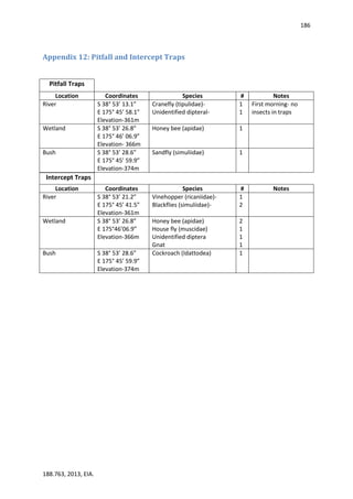
To the Registrar
Environment Court
Auckland, Wellington, and Christchurch
I, [full name], appeal a decision (or part of a decision) (or seek an inquiry of a recommendation or
part of a recommendation) on the following matter:
[briefly describe the application or the review of consent conditions to which the appealed decision or
recommendation relates in enough detail to identify the relevant matter].
I am the applicant (or I am the consent holder or I made a submission on that application or review
of consent conditions).
I received notice of the decision (or recommendation) on [date].
The decision (or recommendation) was made by [name of authority, Minister, or committee].
The decision (or recommendation or part of the decision or recommendation) I am appealing (or
seeking an inquiry of) is:
[state a summary of the decision or recommendation or part of the decision or recommendation].
The land (or resource) affected is:
[give description].
The reasons for the appeal (or inquiry) are as follows:
[set out why you are appealing or seeking an inquiry and give reasons for your views].
I seek the following relief:
[give precise details].](https://image.slidesharecdn.com/eaa0df4b-347e-43e8-b498-a43ef1dd3d8d-150710002958-lva1-app6892/85/EIA-FINAL-172-320.jpg)
![173
188.763, 2013, EIA.
I attach the following documents* to this notice:
(a) a copy of my application (or submission or further submission (with a copy of the submission
opposed or supported by my further submission)):
(b) a copy of the relevant decision (or recommendation or part of the decision or
recommendation):
(c) any other documents necessary for an adequate understanding of the appeal or inquiry:
(d) a list of names and addresses of persons to be served with a copy of this notice.
* These documents must be attached and lodged with the notice in the Environment Court. The appellant does not need
to attach a copy of a regional or district plan or policy statement. In addition, the appellant does not need to attach
copies of the submission and decision or recommendation to the copies of this notice served on other persons if the
copy served lists these documents and state that copies may be obtained, on request, from the appellant.
......................................................................
Signature of appellant
(or person seeking inquiry
or person authorised to sign
on behalf of appellant or person
seeking inquiry)
......................................................................
Date
Address for service of appellant
(or person seeking inquiry):
Telephone:
Fax/email:
Contact person: [name and
designation, if applicable]
Note to appellant or person seeking inquiry
You may use this form to lodge an appeal and to request an inquiry.
You must lodge the original and 1 copy of this notice with the Environment Court within 15 working
days of receiving notice of the decision. The notice must be signed by you or on your behalf. You](https://image.slidesharecdn.com/eaa0df4b-347e-43e8-b498-a43ef1dd3d8d-150710002958-lva1-app6892/85/EIA-FINAL-173-320.jpg)


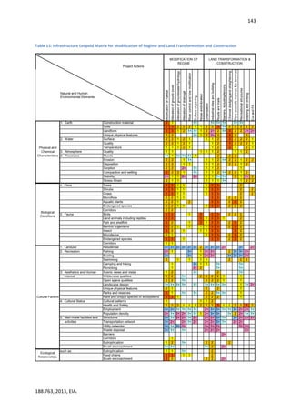
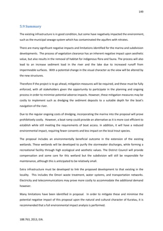
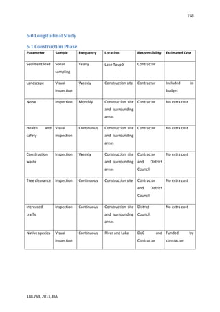
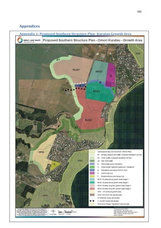
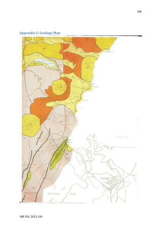
The proposed development faces challenges including development in a significant natural area, liquefaction issues, and high sediment levels in the Kuratau River and its mouth. A full environmental impact assessment is recommended to fully understand and mitigate the potential impacts, which are considered significant. Alternative development options should also be investigated if the current proposal is not approved.


