We know that mesothelioma patients would rather stay local when receiving treatment,rnso we will review options for private medical centers, surgical consultants, clinical trials,rnand match you up with friendly, local physicians wherever we can.
Reflections on Kororoit Institute’s and friends’ planning interventions in light of Supervenience project and where to from here, presented at Melbourne Emergence Meetup 14 November 2019.
Contains main text and images of a submission to the Australian Infrastructure Audit 2019, save for the Supervenience Project principles which are developed in other presentations and with the introductory background of that submission expanded into a longer account of the history of Kororoit Institute's interest in infrastructure. That history also draws on text of submission to VEAC re Coastal Reserves to provide a shortish explanation of the Nepean Bay Bar proposal.
Rockhampton heritage buildings virtual tour of Quay StreetAnna Casey
Virtual walking tour of historic buildings along Quay St Rockhampton, Queensland, from the Walter Reid Centre to the Criterion Hotel. Photos and text.
Links are provided to other sites for deeper information.
features new spring lecture series, Steamboats of Washington on the Pamlico River, history of the Havens Garden Flywheel from a steam powered lumber mill.
A photographic tour of Moon Island and Long Island in Boston Harbor. Of particular interest is the former sewage storage facility on Moon Island and its potential for use in aquaculture.
Three months after the closure of the Port of Portland's T-6 -- Oregon's only international deep-water commercial seaport -- we "take the plunge" into Oregon history and explain something of the economic geography that first lead to the development of the Port of Portland -- WAY back in the 1850's. The KEY: it was nothing more than a low, "floor-level" wagon-road from the Tualatin Valley down to the Willamette River waterfront.. the Sylvan Road into Goose Hollow: the same route now traversed by tens of thousand of vehicles a day, in and out of Portland, through the Sylvan Tunnels.
But in this 21st C economy, this slim 19th C. advantage is no longer adequate or sufficient to enable Portland to maintain its competitiveness as a deep-water port: other economic considerations far outweigh this situation: and so Terminal 6 was closed to deep-water shipping and will never re-open. Despite the fact that geography and hydrology dictate this situation, the media in Portland -- including the Oregonian, OPB, and major "talk" entrepreneurs like Lars Larson on KXL, -- continue to scapegoat the ILWU for slowdowns, and in doing so, not only succeed in slandering labor generally, but also conceal from Oregonians the real cause of the T-6 closure, thus distracting them from understanding where the only real solution lies: namely, at Astoria.
In this 90-day update, we take a look at few of these quaint features of the Port of Portland, that made it such a charming Port city, and show how its harbor facility stacks up against those at the Port of Astoria.
In the autumn of 2019, the first evening of our tripartite autumn conference, Citymakers, explored the catalytic effect of events such as the 2012 Olympics on the transformation of cities. Paul Appleton opened with a presentation of London's Olympic legacy as the case study.
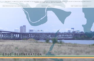
1. Edge RegenerationPost industrial reclamation park along the Westport Patapsco Waterfront
This Project is submitted in partial fulfillment of the requirements for the Bachelor of Landscape Architecture degree in the College of Architecture and Urban Studies of
VIRGINIA POLYTECHNIC INSTITUTE AND STATE UNIVERSITY
Mintai Kim project advisor Terry Clements project SupervisorBrian Katen Department chair,landscape architecture
2. 2
Acknowledgements
I would like to take the opportunity to thank the many people who help me and gave me encourage-
ment throughout this project and over my 5 years at Virginia Tech. First and foremost I would
like to thank my studio family, especially Kaitlin Shealy, I would not be the person I am with
out them. Your assistance, support, and friendship has made my college experience truly great.
I would like to thank my roommates, family, girlfriend who have always believed in me even when
the things were at there lowest. Lastly I would like to thank my advisor and all the staff the
helped me along my educational exploration especially Mintai Kim, Ben Johnson, and Wendy Jacobson.
3. 3
Contents
Introduction .....................................................4
Research .......................................................16
Analysis .......................................................25
Design ........................................................38
Conclusion ....................................................50
Sources ......................................................52
Westport History
Context
Past Industry
Present Westport
Project Goals & Vision
Phytoremediation Process/Methods
Neighborhood scale Analysis
Master Plan
Westport Waterfront Welcome Center
Plant Selection
Past & Present Remediation Strategy
Neighborhood scale Synthesis
Site scale Analysis
Wetland Machine
Site scale Synthesis
Circulation
Bibliography
Images
Reflection
Concept
4. 4
Introduction
This image from Baltimore Washington Parkway (295) overlooks the Patapsco Middle Estuary and the view
out from the Westport waterfront. It depicts the rich history visible from the shore line including
the Hanover Bridge in the distance and the nonfunctional industrial rail bridge. To the right, closer
to Westport, the Baltimore rowing club is still an active water recreation.
5. 5
Introduction
Context
I chose to study the Patapsco Middle Estuary because
the Westport, Baltimore condition is emblematic in
many ways of most major metropolitan cities located
along the eastern shore. All to common valuable wa-
terfront is developed by industry polluting the soil,
water, and habitat on site and degrading the adjacent
land. As the industry declines, vacating the water-
front, it leaves behind dangerous contaminants and a
disconnected waters edge that renders it unusable for
anything. Baltimore has always been close to my heart
as I have taken many trips there as child and still
today. From my visits I saw an obvious need to heal
this waterfront, especially along the Patapsco Middle
Branch. The Westport waterfront is an opportunity to
create a restorative landscape that tells the history
of this neighborhood and act as a framework for oth-
er cities experiencing similar waterfront obstacles.
This projects combines my passion for plants along
with my exploration of waterfront development serving
as an activator for urban cities.
54.3 Acres
6. 6
1773 1850’s 1895
1800’s 1889 1904
John Moale bought tracts of farm land adja-
cent to the Patapsco Middle Branch to con-
struct an iron furnace at the mouth of the
Gwynns River Falls. The furnace was in opera-
tion until the end of the Civil War. African-
Americans, both free and slave, made up the
majority of the iron workers.
1F1
2F5 2F6 1F7
During this period of growth Westport be-
came a popular resort destination because
of its sandy beaches and wildlife. It be-
came such a popular destination for swim-
ming, fishing and eating centered around
the Smiths’s Cove and is still the home
of the Baltimore Rowing/Aquatic center.
Famous Landscape Architect Frederick Law Ol-
mstead developed a master plan for the Gwynn
River Falls and the Patapsco Middle estuary
to make water front park and recreational
area. However before his vision could be ful-
filled the Great Baltimore Fire struck.
Westport’s location near a major junction of roads, railroads;
joining Baltimore, Washington, and Annapolis and the Patapasco
river made this once rural neighborhood an ideal location for
commerce and recreation. Westport experiences large population
and construction growth.
In 1889 the Carr &n Lowery Glass Works
Factory opens on the water front of the
Patapsco estuary which ushers in a near
wave of industrialism and development in
Westport. Nearly 200 homes are added for
factory work, most of German decent.
The Great Fire of Baltimore struck
destroying most of the harbor and
industrial area. Much of the debris
created during the fire was recycled
and used as fill to expand and
build the industrial area in West-
port.
1906
Consolidated Gas & Electric Pow-
er Company constructs the Westport
Power Plant. It is said to be the
largest reinforced concrete gener-
ating power station.
Westport History
Introduction
1F31F2
7. 7
1916 1923 1952 1992
2F8 1F9 2F10
Hanover Street Bridge is construct-
ed to connect the North and South
banks of the Middle Branch. It also
connects the Glass Works Factory to
the major industrial area. The West-
port neighborhood is said to have
the best view of this iconic bridge.
By the mid to late 20’s the city re-
zones Westport as industrial land. Due
to its idea location next to the Middle
Branch and adjacent roads and rail lines
industrial factories take over the wa-
terfront cutting off the access to the
Patapsco estuary.
The Baltimore-Washington Parkway
(295) is opened. This four lane ma-
jor interstate cuts through the mid-
dle of Westport dividing the neigh-
borhood and permanently alters the
geography.
Baltimore’s light rail starts service along
a 22 mile corridor with a stop in Westport
along the Patapsco waterfront. The light
rail connects Westport with downtown Bal-
timore with transit links to BWI Airport
and Penn Station.
1920 1951
By the early 1920’s Westport had its
own school, fire department, and the
Enoch Library. By the end of the
20’s most of the present day row
houses were built.
Introduction
The 14 mile Gwyenns Falls trail is
opened along the river front in an
attempt to achieve Olmsteads vision
for the Westport community.
1990’s
In 1951 the Westport community is home to
2000 + citizens and has earned the reputa-
tion as a peaceful quiet neighborhood with
a “bustling main street” (Annapolis Rd.)
with a movie theater, hardware store, a
drug store, and a bank.
Westport History
1F4
8. Source: Esri, DigitalGlobe, GeoEye, i-cubed, USDA, USGS, AEX, Getmapping, Aerogrid, IGN, IGP, swisstopo, and the GIS User Community
Source: Esri, DigitalGlobe, GeoEye, i-cubed, USDA, USGS, AEX, Getmapping, Aerogrid, IGN, IGP, swisstopo, and the GIS User Community
8
Past Industry
Introduction
History: Carr Lowrey Glass Company founded
in Baltimore, Maryland in 1889 by Samuel Carr
and William Lowrey who established their com-
pany to create glass bottles for the pharma-
ceutical and perfume industries. Soon after
the Glass company took off and became the
largest employer of Westport residents during
its peak production. The company was so suc-
cessful that it became one of the first Glass
factories to be equipped with an IS machine,
which is used to speed up the bottling pro-
cess. In 1944 the company was acquired by the
Anchor-Hocking Glass Company however, shortly
after changing hands the company began to de-
cline. With the advent of plastics and compe-
tition from other companies the glass busi-
ness. In 2003 the factory closed its doors for
good, shortly after the Inner Harbor West LLC
purchased the land for $6.82 Million and de-
molished the history industrial facility with
plans to rebuild the desirable waterfront.
History: Formally owned by Baltimore Gas and
Electric (BGE), now Constellation Energy, the
Westport power plant was built in 1906. This
concrete and steel giant was the largest re-
inforced concrete building in the world when
it was first constructed. The coal fired power
plant generated energy for Baltimore city until
1993 when it was closed down. During it time of
operation this plant was a large employer of
Westport residents. In 1995 the massive vacant
building served as the set for the movie “12
Monkeys” Starring Brad Pitt. The Plant stood as
a testament to Westport industrial legacy until
2003 when Inner Harbor West LLC purchased the
property and demolition began in 2007 to make
way for water front redevelopment.
Located by major industrial rail lines the
coal fired plant was in an ideal site to
prosper
Patapsco Middle Estuary with industry adjacent
to the waterfront prior to demolition
Pollutants the groundwater and soil
-Elevated levels of metals including
-Arsenic, chromium, lead, mercury,
nickel, and Zinc
- Volatile organic compounds
-Arsenic and petroleum hydrocarbons
Pollutants: in the groundwater and soil
-Elevated levels of heavy metals in soil
-Lead, mercury, and Zinc
- Volatile organic compounds
-Petroleum hydrocarbon leached into
groundwater
1F11
3F12
9. 1822
9
Introduction
Once hailed as the “natural Oasis” of Baltimore, the Middle Branch and mouth of the Gwynn Falls River was
a popular beach destination. This beautiful location nicknamed the “Monte Carlo” of Maryland was an urban
escape from Baltimore where citizens came to eat, relax, swim, and fish this diverse ecosystem. Over the
years of industrial process, contamination, & land manipulation the Middle Estuary ecology and extent has
changed drastically. Today the Middle Estuary does not resemble the popular thriving habitat that it once
was. Habitat destruction the water and surrounding ecosystem is barley usable for anything from its past
time. The water is bulk headed along the coast line and so badly polluted, mostly with heavy metals, that
it hardly supports life and is not safe to interact with. This graphic shows the endangered or threat-
ened species of Baltimore City that live near or on the water and the extent of the wetland degradation.
Past Industry
1875 1903
Evolution of the patapsco Estuary
1970
Current
10. 10
Past Industry
Introduction
There are no residential units
West of I-95 at this northern most
section of Westport. This zone of
Westport is dominated by industri-
al lots which creates barriers.
Gwynn Falls River is surround-
ed by industrial lots that
pollutes the river and limits
access to the rivers edge.
There are few residential units at the north-
ern edge of Westport. Most of the soil is con-
taminated creating a toxic living environment.
There is not as much of a need to create con-
nections into the North Westport.
The municipal electrical facility takes up al-
lot of space in Westport which limits acces-
sibility to the Patapsco. The light rail line
elevates and allows for a much improved auto-
mobile connection to the Water front.
The middle portion of Westport is less imperative to repair
the connection across I-295 because there is not as many
residential units. The Mt. Winans Housing development, which
is not fully completed, will bring in a higher density but
right now it is a fenced off vacant lot.
The interstate right of way widens to
meet the department of transit storage
lot making it impassable. The grade rises
sharply and meets the back alley/vegeta-
tion of the row homes. This is the densest
section of Westport.
Row homes back up to the Westport light rail
station. Kent street is the only street
that provides access to the station. The
tracks and the retaining wall separate the
residents from the Patapsco.
There are no residential
units West of I-95 at this
norther most section of West-
port. This zone of Westport
is dominated by industrial
lots which creates barriers.
Gwynn Falls River is sur-
rounded by industrial lots
that pollutes the river
and limits access to the
rivers edge.
There are few residential units at the
northern edge of Westport. Most of the
soil is contaminated creating a toxic
living environment. There is not as
much of a need to create connections
into the North Westport.
The municipal electrical facility
takes up allot of space in Westport
which limits accessibility to the Pa-
tapsco. The light rail line elevates
and allows for a much improved auto-
mobile connection to the Water front.
11. Introduction
11
3.
The site of the Carr-Lowery Glass Factory is the
most accessible area of the water front by automo-
bile traffic. However this section has the fewest
residents. Traffic connection will need to be made
into the residential zone of Westport.
2.
The water front access to the light rail
station is located near this section of
Westport. This section of the water front
has a lot of debris and piles of construc-
tion waste/dirt.
1.
The site of the Carr-Lowery Glass Factory is
the most accessible area of the water front by
automobile traffic. However this section has
the fewest residents. Traffic connection will
need to be made into the residential zone of
Westport.
1
2
3
The Westport community was originally founded in an ide-
al location for transporting industrial goods via rail,
road, or shipping. Today however, with a collapsing in-
dustry, Westport suffers from fragmentation and dis-
connection due to that infrastructure. Major transit
artery 295 cuts straight through the middle of the com-
munity dividing Westport in two parts, East Westport &
West Westport. With only a narrow walking bridge link-
ing the two, the heritage and culture of West Westport
is essentially forgotten. Further to the East light rail
lines create a neighborhood boundary that separates the
residents of East Westport from the Patapsco Middle Es-
tuary. The infrastructures that cuts thought Westport
divides the neighborhood from itself and contributes
to the decline of the neighborhood. The industry left
the beautiful waterfront disconnected and inaccessible.
The only pedestrian access
across 295 is a small pedes-
trian bridge that links East
and West Westport. Elementary
school students cross this
bridge to go to school every-
day
Westport light rail sta-
tion forms the border to
the east of East Westport
cutting the residents off
from the Middle Branch
Past Industry
12. 12
Along with a fragmented neighborhood the industry
also left behind major soil and water contamina-
tion. The largest source of pollutants are heavy
metals in the form of lead, zinc, mercury, Arsenic,
nickel, and chromium. In addition there are also
volatile organic compounds (VOC’s) and Polychlori-
nated biphenyls (PCB) to a lesser degree. The maps
taken from the Chesapeake Bay Programs illustrates
the source of pollutants entering the Bay. The in-
dustrial pollution has degraded the once vibrant
waterfront of Westport and rendered the waterfront
unusable and disconnected. The Patapsco rivers and
side streams are among the most polluted water ways
in the Chesapeake Bay. The map to the right shows
how contaminated it is in comparison to the other
water ways. The Patapsco river is severely impaired
and continues to be polluted by storm water runoff
from the neighborhoods. Blow (F2) depicts the imper-
vious surface surrounding the Patapsco which drains
to the water ways continuing to supply heavy metals
and VOC’S
Past Industry
Introduction
4F13
5F14
4F15
13. 1
2
12
9
10
11
4
8
3
6
7
13
Present Westport
3
Westport Elementary is on the Western
side of 295 with a pedestrian bridge
spanning the gap. The school is discon-
nected from the greater Westport neigh-
borhood.
10
Condemned home on Annapolis Rd., this is
not uncommon to see in this community as
25% of the homes are vacant or condemned
8
Gas Electric Power Plant,
punctuates the skyline of
Baltimore City. This icon-
ic smoke stack is the first
thing you see as you enter
from the south on 295.
5
Introduction
7
Annapolis Rd., is the “Main St.” of
Westport with a great view of Balti-
more’s Central Business District & M&T
Bank Stadium.
M&T Bank Stadium, home of the
Ravens. Visible from within
the Westport.
1
11
Electric facility, on the edge of the Westport community
adjacent to the vacant Glass Factory property. Active and
dormant rail lines crisis cross the area that runs along
the Gwynn River Falls Trail.
9
Old Rail Bridge is unused and stands vacant in the middle
of the Patapsco Estuary. Relics of the industrial legacy
are scattered throughout Westport.
Westport Light Rail Station,
view to the Downtown. Light
rail runs adjacent to the
Gwynn Fall Trail/Middle Branch
Trail.
12
6
Mt. Auburn Cemetery, one of the oldest
African-American burial grounds in the
country. Currently this cemetery is in a
state of decline and undervalued.
4
Storm water drains to the
Gwynn Falls River. The riv-
er is unadulterated and se-
verely polluted.
6F16
7F17
14. 14
Introduction
Present Westport
Community Demographics
The Westport neighborhood is young poor black commu-
nity that is in distress. The lose of the water front
employment (glass factory and power plant) has forced
this community into a state of poverty & decline of
the built environment. The built environment affects
how people use space and interact with one another and
has impacts on health. The high percentage of vacant/
condemned buildings and poverty creates a lack of com-
munity pride and high crime rate. The general socio-
economic conditions & crime rates all impact a neigh-
borhood’s social environment. These elements interact
to shape opportunities for community health in many
ways. The health of Westport is below average because
of a lack of employment, high crime, and a high degree
of poverty. This is ultimately reflected in the life
expectancy of the average Westport resident (68.8 yrs)
compared to the average life expectancy of Baltimore
City (72.8 yrs). The community is in need of shared
common space to bring the community together.
0.0% 5.0% 10.0% 15.0% 20.0% 25.0% 30.0%
0-17 years
18-24 years
25-44 years
45-64 years
65+ years
Baltimore
Westport
Race DistributionAge Distribution
Westport is comprised of mainly a younger school age and middle
age adult population with 61% of family households, that is more
than a third greater than the city average. There is a large num-
ber of young children, The Patapsco Water front development can
provide amenities for these young families of Westport.
There is a disproportionate number of black residents compared to
white residents. Historically Westport was predominately a white
European community however over the generations, especially after
the water front closed, the race has shifted. The new population
should be included in the waterfront but should also celebrate the
past.
0.0% 10.0% 20.0% 30.0% 40.0% 50.0% 60.0% 70.0%
Black
White
Asian
Hispanic
Baltimore
Westport
Vacant Lots Household Income Home Foreclosure/Value
Westport is a relatively poor community in Baltimore with the
average family income around $35,467 compared to the Baltimore
average $44,721. With the main economic drivers (Power Plant
& Glass Factory) leaving the unemployment rate was roughly
17%,the community needs more viable employment opportunities.
Westport is considered to be a distressed neighborhood by the
City of Baltimore with over 22% of the row homes condemned or
abandoned.
0.0% 10.0% 20.0% 30.0% 40.0%
Less than $25,000
$25,000-$39,999
$40,000-$59,999
$60,000-$74,999
$75,000 and over
Baltimore
Westport
US Average
Baltimore City Average
Westport Average
US Average
Baltimore City Average
Westport Average
The housing market in Westport has suffered a lot since the clo-
sure of the water front factories in 2003. The number of fore-
closures has risen steadily over the past decade. Westport has a
high percentage of its residents living below the poverty level
(29.3% of families) compared to Baltimore city average (15.2%).
8F18
8F19
15. 15
Introduction
Project Goals & Vision
Vision Statement
Goals & Objectives
Clean the westport waterfront to restore it back to its valued state as a natu-
ral escape from Baltimore and reconnect the resident to the waters edge while
telling the story of Westport.
Improve the ecological health of the Gwynn Falls River and the Patapsco Middle
Estuary
-Collect and treat the runoff before it gets to the water system.
-Employ an adaptive phytoremediation strategies to improve the health of the water ways.
-Buffer the industrial areas to create a riparian buffer.
Connect residents of Westport to the natural systems
-Utilize the site of the old Glass Factory and other historically important locations to create
Places the allow people to use the waterfront.
-Green the Gwynn river and Middle Branch Trail to improve the green infrastructure and create a
Trail that runs adjacent to the rivers edge.
-Educate the visitors on the process of phytoremediation and value wetlands
Narrate the history of Westport
-Re imagine the historic Patapsco waterfront
-Describe the past present and future of Westport in treatment of the land
-Highlight the industry and re purpose the unused rail line where ever possible.
16. 16
Research
This image of the Gwynn River is taken near the Baltimore Solid Waste Incinerator Plant. It shows how
degraded the site ecology has become over time due primarily to industrial intervention and pollu-
tion. In order to repair the site it is important to clean both the soil and the water of the current
neighborhood and the past industry. The Westport waterfront is a great location to employ an adaptive
phytoremediation to clean the past pollutants and the present inputs from the surrounding neighborhoods
using a diverse plant pallet and a wetland storm water collection zone.
17. 17
Phytoremediation Process/Method
1. Identify the Pollutants location on site,
Research the plants to treat them.
The areas with the highest concentrations of heavy
metals (Lead, Mercury, Zinc, Arsenic, Nickel, and
Chromium) must be identified to keep people off of that
land. In addition to toxins soil compaction should
also be identified as a design consideration for the
hydraulic residence time of the constructed wetlands.
It is important to identify where the upland contami-
nants are coming from to isolate and treat these as
well to stop further degradation of the waterfront
and adjacent water ways. The EPA Superfund sites are
an extremely dangerous point source of pollution that
should be identified for future restoration.
Research
Annapolis Road
Source: Esri, DigitalGlobe, GeoEye, i-cubed, USDA, USGS, AEX, Getmapping, Aerogrid, IG
0 0.1 0.2 0.3 0.40.05
Mile
Chemical Metals, Inc
EPA Superfund sites that are extremely
polluted. Currently the plums are migrat-
ing toward the Gwynn River
18. 18
X
Plants uptake contaminates and
store them in the leaf portion
of the plant where the pollut-
ants are degraded producing a
less toxic form. The contami-
nants are evapotranspiration
out of the leaves into the atmo-
sphere. Limited research shows
that these plants should not be
planted around residential ar-
eas.
Plants uptake or isolate
contaminates in the soil and
release enzymes/metabolic
processes/fungi to break
down pollutants. Plants also
degrade heavy metals around
the rhizosphere in a process
called rhizo-degradation/
filtration. Plant selection
with a large fibrous root
system are the best at this
process. Treatment depth of
about 9’.
Phyto-volatilization
Phyto-degradation
Phyto-extractionPhyto-stabilization
2. Plant the selected species on the polluted areas and
monitor the growth.
Plants can sequester/immobi-
lize contaminants by absorbing
them in the root zone called
the rhizosphere. Plants ex-
ude enzymes and chemicals that
reduce the contaminates to a
less toxic state and limit the
migration of pollutants from
ground water leaching. This
process is called phytodegra-
dation which is closely relat-
ed to rhizo-degradation.
Plants uptake metals and
translocate the pollut-
ants in above ground por-
tion of plant. The most
important aspect of ex-
traction is the amount of
biomass Effective treat-
ment depth of about 3’.
Phytoremediation Process/Method
Research
9F20
Extreme pollution not safe for contactModerate pollution safe for contact
19. 19
3. Develop a maintenance plan to dispose of contaminated biomass.
There are three main disposal methods to safely har-
vest contaminated biomass off site (mainly involving
phyto-extractors). The cheapest method is to compact
and compost the plant matter in protected site which
greatly reduces the volume of harvested biomass but
does not treat the contaminates. Another process is
to dispose of the plant mass in a lined landfill which
does not clean the metals but makes it so that the
metals cannot migrate. The last method and perhaps
the most common is to take the contaminated biomass
to an incinerator plan which burns the plant mater
producing Ash and vapors. The metals can be collected
from the ash residue and recycled, while the vapor
gets cleaned and can be used as a source of energy in
the form of oils and tar to produce heat and electric-
ity. This is the best method because it offsets the
remediation costs and there is an incinerator plan
right next to the Westprot Waterfront.
The Baltimore solid waste incinerator plant is located on the
opposite side of the Gwynn Falls right next to the Westport wa-
terfront making incineration a convenient maintenance strategy.
Phytoremediation Process/Method
Research
10F21
20. 20
The soil treatment method in the lesser polluted areas of the Westport
waterfront employs two strategies. Phyto-degtradation & stabilization.
These process collect, trap, and detoxify the pollutants in the below
ground portion of the biomass. In addition these contact safe plant treat
a wide variety of existing soil contaminates including the limited or-
ganic contaminates on site. The process cleans the soil contaminants in
the rhizosphere which makes these plant species safe for visitors to be
in contact.
In the more heavily polluted areas of the waterfront (storage areas and
factories) the treatment method employs phytoextraction/accumulation.
These plants are the most effective at cleaning heavy metal contaminated
soils but the trap and store the metals in the above ground biomass of
the plants. This aspect makes these species “not safe for human contact”
and there fore they will be confined to the heavy pollution/wetland area.
The wetland vegetation is also equipped to treat the organic pollutant/
metals in the storm water runoff in the wetland cells.
Safe For Contact Not Safe For Contact
Hg
AsCr
Pb
Zn Cr
Cr
Cr
Cr
VOC
VOC
Pb
Pb
Pb
Ni
Ni
NiHg
Hg
Zn
Ni
Ni
VOC
VOC
N
N
Cr
Cr
Pb
Pb
Ni
Ni
P
P
Hg
As
As
As
Zn
Zn
Zn
Ni
Stormwater Runoff
Ni
Ni
Cr
Cr
Pb
Pb
Zn
Zn
N
P
VOC’s
VOC’s
Research
Past & Present Remediation Strategy
21. 21
Research
Past & Present Remediation Strategy
Constructed Wetland Zones
Root Depth
Biomass
Regeneration
Typical root depth should be be-
tween 3’-6’ and fibrous to trap/
collect pollutants. The larger
the rhizosphere the more con-
taminant are trapped in the be-
low ground portion of the plant
species.
The larger the biomass the more
pollutants are collected and
stored in the above ground por-
tion of the plant species. This
dictates how frequently mainte-
nance is required. The faster the plant spe-
cies sends out shoot and
suckers the more soil the
plant can cover. This is
critical for removal of
contaminated biomass and
repopulation after main-
tenance.
Not safe for contact: The Phyto-extractors
plant species are the most efficient at cleaning the
soil and ground water and therefore should be plant-
ed in the areas with the highest concentrations of
heavy metals. Because many of these species accumu-
late metals in the above ground portion of the plants
these species are not safe for human interaction. In
addition, the wetland ecosystem and process is very
delicate and should not be interfered with therefore
it makes sense to plant the storm water wetland with
the extractor species to clean the current runoff
from Westport and the past contaminants left behind
from the industry. This will provide the most “clean-
ing” potential to restore the site and keep it clean
into the future. Below is a diagram of costal wetland
depicting the different zone. The plants were spe-
cifically selected to accommodate each of the zones
and meet the three different phytoremediation plant
selection criteria to the left.
Plant Selection Criteria
22. 22
Past & Present Remediation Strategy
Aquatic
Lead Mercury Zinc Arsenic Nickel Chromium
Submerged Emergent Terrestrial
Azolla filiculoides
• floating aquatic fern
• Very fast growth
• Capable of spreading
over lake surface
• Treats a wide variety
of heavy Metals.
Pistia stratiotes
• Among the world’s most
productive freshwater
aquatic plants.
Salvinia cucullata
• Fast growing aquatic
brackish water fern
• Considered an inva-
sive species
• Fine roots,effective
at accumulating heavy
metals.
Eichhornia crassipes
• Free-floating
• Extreme growth rate
• Each plant produces
thousands of seeds
• Form large colonies
Lemna gibba
• Exhibits a fast
growth rate that can
• Cover large aquatic
areas.
• Extremely tolerant of
adverse conditions.
Myriophyllum sibiricum
• Tolerant of brackish
water
• Fibrous root provides
large surface area to
absorb.
• Grows completely sub-
merged
• No true roots
• Widespread global dis-
tribution
• Grow in adverse condi-
tions.
Myriophyllum spicatum
• Habitat includes fresh
to brackish water
• Tolerant of many water
pollutants
Potamogeton pectinatus
• Grows in fresh and
brackish water
• Found on all conti-
nents
Elodea canadensis
• Grows rapidly
• Tolerates wide vari-
ety of conditions
• Choke shallow ponds.
Hydrilla verticillata
• Grow to the surface
and forms dense mats
• Found in all types of
water bodies
• Can be considered in-
vasive.
Potamogeton natans
• Produces both float-
ing and submersed
leaves
• Grows in brackish wa-
ter
Typha angustifolia
• Found in or near water
• Periodically flooded
areas
• Like brackish marshes.
Phragmites australis
• Large perennial grass
• Native to North Amer-
ica
• Tolerant of adverse
conditions.
Scirpus maritimus
• Extremely adaptable
• Survives under saline
conditions
• Found around the world
• Tolerant of drought
and flooding
Spartina patens
• Grows in thick mats 1
to 2 feet high
• Grows further back
away from shore that
experiences occasional
high tide flooding
Spartina alterniflora
• Regarded as a habitat
engineer
• Tolerant of adverse
condition
• Grows in shallow wa-
ter
• Excellent accumulator
of a wide variety of
Heavy metals.
Salix sp
• Found primarily grow-
ing in moist soils
• Takes-up large quan-
tities of heavy met-
als
Solidago hispida
• Tolerates poor, dry
soils
• Hyper-acumulator of
many types of heavy
metals.
Gleditsia triacanthos
• Fast growing native
species
• Extremely hardy and
adaptable.
Bassia scoparia
• Grows quickly/toler-
ates adverse condition
• Tolerates salt condi-
tions
• Remediates wide vari-
ety of pollutants.
Digitalis purpurea
• naturalized in North
America
• Prefers to grow in
moist soils in full
sun conditions
Canna indica
• Large biomass to accu-
mulate metals
• Tolerates consistently
moist soil
Ceratophyllum submersum
Alisma plantago-aquatica
HAHA
HA
HA
HA
HA: Hyperaccumulator
Research
HA
HA
HA
HA
23. 23
Past & Present Remediation Strategy
Research
Hydraulic Residence Time
Vegetation density is an issues previously discussed in
regards to phytoremediation of heavy metal. It is also
an important factor in wetlands. High biomass vegetation
helps to slow surface water flow rate. The water entering
the site transports heavy metals and suspended particles,
the vegetation slows water and allows for the particles to
settle on the media.
Pb
Zn
Vegetation
Slope
Water is the most critical component of a wetland, without water is there is no
wetland. Westport most be analyzed with regards to the wetland hydrology criteria.
There are 2 main factors that influence wetland hydrology, 1.Continuous source of
water to periodically inundate the wetland cells. The source of water should be
large enough to support the typical wetland cell 2. water retention time,(residence
time) this is the length of time the water remains in the system before it is evapo-
rated, leached, or exported out. This aspect of wetland design is perhaps the most
important because the length of time that the water is in contact with the substrate
and vegetation directly correlates to the amount of contaminants extracted. The
longer the contaminates are in contact with the media the more sediment settles and
cleaned. Residence time is dictated by three main factors; slope, compaction, and
vegetation.
As
N
P
Hg
VOC
Ni
Ni
Slope controls the speed at which surface water enters the
system. Wetlands should be designed on a gently sloped sur-
face to feed the wetland using gravitational flow so that
there is continuous input. The ideal slope for a wetland
is between .5%-3%. It should also be located near a large
enough source and away from residential area to prevent any
unintended interference.
Zn
Cr
Pb
Compacted Sub-soil
Compacted soil allows water to accumulate before it perco-
lates through the substrate. This ponding effect is neces-
sary to allow the presence of aquatic wetland species and
increases the biodiversity. Aquatic zone plants are more
efficient at extracting pollutants then terrestrial plants
because the dissolved particulates are in direct contact
with the floating roots. The ideal holding time for a wet-
land is between 3-5 days to allow for cleaning.
As
Hg
Ni
Zn
Cr
Pb
Cr
24. 24
Lead Mercury Zinc Arsenic Nickel Chromium
Manicured Meadows
Forest
Natural Meadow
Cynodon dactylon
• Considered invasive in warm areas
• Rhizofiltration
• Stores metals in the root zone and
degrades contaminants
• Deep rooting
Carex sp.
• Extremely tolerant of moist soil
• Tough versatile species
• Treats a wide range of contami-
nants
• Large biomass
Lupinus albus
• Arsenic primarily stored
in the root structure
• Nitrogen fixing legume
• Fibrous root system
Festuca arundinacea
• Native to the metro area
• Deep root zone to trap and break
down organic compounds/metals
• Treats a wide range of pollutants
• 4’ deep roots
Vetiveria zizanioides
• Bronze purple fall color
• Vertical clump up to 8’
• Deep roots/regenerates quickly
Rhaphiolepis umbellata
• A slow growing evergreen
• Drought tolerant
• Grows to about 5’, and has
fragrant flowers
Lolium multiflorum
• Good turf grass
• Hardy durable grass that can han-
dle traffic
• Treats a wide range of pollutants
Juncus effuses
• Grown in wet soils, including
standing water
• No serious insect or disease
problems
• Spread by creeping rhizomes
Populus deltoides
• Salt tolerant
• Shallow fibrous roots
• Tolerates saturated con-
ditions, but can tolerate
drier conditions as well
Sorghum halepense
• Grows and spreads quickly
• Thrives in open disturbed areas
• Treats a wide variety of pol-
lutants.
Glycine max
• Cultivated worldwide, most pro-
duction in the U.S.
• Weedy in eastern North America
• Stabilizes many metals
• Large root biomass
Polygonum lapathifolium
• Slow growth rate
• Grows well in moist salty
soil
• Treats metals well using a
variety of methods
Raphanus sativus
• Widely naturalized species
• A weed of disturbed sites
• Treats a wide range of pollutants
Sparganium eurycarpum
• Partial wetland species can
tolerate periodic flooding.
• Grow in moist soils in full
sun conditions
Pinus taeda
• Hydraulic control method to
isolate and degrade pollut-
ants
• Native to Southeast US
• Deep rooting
Avena sativa
• Vigorous growth
• Relatively free from diseases
and pests
• Regenerates quickly
Poplulus trichocarpa
• Excellent at treating a va-
riety of contaminants
• Shallow and wide-spreading
roots stabilize metals
PD
M
PD
M
PD
PD
M
M
PS
M
PD
PD
PS
PS
PD
PS
PS
Past & Present Remediation Strategy
Research
PS: Phytostabilization PD: Phytodegradation M: Multiple
SAFE FOR CONTACT: A different plant pallet should
be selected for areas of lesser pollution where residents
are going to be in direct contact with the plants. Ex-
tractors are the best phytoremediation strategy to clean
heavy metal sites however they do have their limitations
such as; they must be constantly maintained, observed,
and cannot be ingested or handled by people or animals.
The lesser polluted areas of the site are still dangerous
for people and must be cleaned. This can be done using a
combination of degradation & stabilization methods which
treats/collects contaminants in the below ground portion
of the plants. This makes these species safe to touch but
are not as fast at cleaning the site. Just like the ex-
tractors these species were selected for deep root zone,
regeneration, and biomass to treat the desired area and
depth. These plants will require less maintenance than the
extractors.
25. 25
Analysis
This image is taken on the Gwynn River Falls Trail along Kloman St. across from the historical
coal fired power plant. Westport is a interesting mix of infrastructure, zoning, and condi-
tions. Each aspect of the neighborhood should be analyzed in consideration of phytoremedia-
tion, constructed wetlands, and the challenges of connectivity that industrial areas pose.
These focus areas begin to reveal the opportunities and constrains as it relates to restoration
and connection to the waterfront.
26. 26
Neighborhood Scale Analysis
Analysis
Topography
Analysis
Zone
Analysis
The Westport topography has been artificially manipulated to construct
the infrastructure that crisscrosses the neighborhood. The steepest
slopes are adjacent to interstate 295 that divides East Westport and
West Westport. To the north of Westport, on the opposite side of the
Gwynn Falls River, the grade becomes steep again to elevate I-295 over
the river and connect the major artery to I-95. The majority of the wa-
terfront is flat except to the south where the Smiths cove inlet meets
the land. Other small mounds/leftover debris are scattered across the
waterfront as well; these should be clean on site as well. Their is a
retaining wall adjacent to the site that serves as the commuter rail
station. The steep slopes do not allow automobile access however there
is pedestrian access to the station that should be emphasized.
The Westport neighborhood has a diverse range of “zones”. This creates
for an interesting set of edge conditions that don’t necessarily mesh
well together. These zones are often separated by serious infrastruc-
ture that cuts through the topography making it difficult to make con-
nections between these zones. The industrial areas are located along
the water (Gwynn Falls,Patapsco Estuary), some of these zones will need
to be buffered to mitigate human interaction. The connections into the
residential areas are stressed because of topography and infrastructure
in the form of rail roads.
Legend
Legend
Positive Views
Post-Industrial Edge
Industrial Edge
Residential Edge
Disconnected Edge
Vegitated Edge
High Point
Steep Slope
Moderate Slope
27. 27
Neighborhood Scale Analysis
Analysis
Transit
Analysis
Hydrology
Analysis
The infrastructure of Westport is intriguing because there is a diverse combination of
old/new, large/small scale transportation arteries. Adjacent to the waterfront the com-
muter and industrial rail runs along the length to service the vacant industrial lots.
The Gwynn Falls Trail shares the same path as the rail system and splits going into
the industrial area. The trail provides pedestrian access to the commuter rail station
and waterfront. Annapolis road, Main Street, is in a state of degradation although,
there is still a lot of culture connected to it. At either end there are critical nodes
that provide access across 295 and provide a connection to the Gwynn Falls. The walk-
ing bridge is the only pedestrian access across 295. I-295 splits Westport at grades
and then elevates as is continues into the industrial corridor. The abandoned railroad
in the Patapsco provides an opportunity to bridge the estuary and better connect the
waterfront.
The residential zones of Westport are well outside of the flood plain
however, the industrial areas to the north are well inside the 50 year
flood plain. The welcome center should be located well outside the
flood area and flood BMP’s can be employed where flat open space is
available. The edge of the Patapsco is highly manipulated and effects
the edge of the flood plain. Lastly sea level rise does not have any
effect on the site due to the bulk head that runs the length of the
waters edge.
Above Grade Road
At Grade Road
Critical Road
Commuter Railroad
Industrial Railroad
Abandoned Railroad
Pedestrian Trail
Pedestrian Connection
Important Transit Node
Legend
Legend
Historic Patapsco
Flood Plain
28. 28
Neighborhood Scale Analysis
Analysis
Cultural
Analysis
There are many positive and negative opportunities provided in Westport. There are many vacant lots espe-
cially at the waters edge (both natural and artificial. At the artificial edge of the Patapsco the historic
industrial buildings are no longer standing however, the foot print could be converted into a wetland/
BMP to protect the rest of the industry from floods. Because the economic drivers left Westport fell into
a state of poverty resulting in 22% vacant/condemned homes. Along Annapolis Rd. there are some critical
Westport buildings that are slated to be reproposed by the Westport Neighborhood Association and the old
materials can be reused in the waterfront. However, East Westport is in a better sociocultural state and
contains critical open space including Mt. Auburn Cemetery and the Elementary school and adjacent park
land.
Important Open Space
Important Cultural Bld.
Vacant Bld./Block
Vacant Lot
Open Green Space
Super Fund Site
Historic Industry
Legend
29. 29
Analysis
Overview
Neighborhood Scale Synthesis
Overlaying the analysis begins to inform where the
most disconnected points are along the waterfront. In
addition the synthesis reveals where there is most
potential for automobile and pedestrian access to
bridge those gaps. The light rail station is a criti-
cal connection that should be made stronger but steep
topography limits the opportunities. The vacant rail
bridge offers a great opportunity to bridge the Pata-
psco and bring people to the waters edge, this link
should be emphasized . The synthesis also shows the
majority of culturally important nodes are located
in west Westport and disproportionately less in East
Westport. The western side of Westport is more open
but has little opportunity to connect it to the wa-
terfront via the light rail and pedestrian trails.
Waterview Ave. is the only road that bridges 295
therefore, the link to the Gwynn River Falls should
be preserved to engage the entirety of the neighbor-
hood. The majority of the site is relatively flat in-
side the flood plain but gets steep towards the south.
There are few constraints in the flood plain but the
largest portion of the flood plain is surrounded by
infrastructure and industrial processes. These areas
should be buffered and the active recreational areas
should avoid them as well.
30. Zone Mapping Study
Hard edge provides opportunity to
bring people to the waterfront and
experience views of Baltimore
Residential zone is bordered on
three sides by various industry.
Two of the three sides contained
my infrastructure. Bridging the gap
between the waterfront is critical.
Open space is inacces-
sible, habitat preser-
vation.
Contaminated post industrial
zone is adjacent to the ac-
tive and should be buffered.
Clear distinction between ac-
tive and historic industry
Soft edges create a allows for wetland
habitat to enter the site and creates
an area for bird watching recreation
30
Site Scale Analysis
Analysis
There are multiple edge conditions within the
post-industrial waterfront and the adjacent lots.
The majority of the waterfront is open vacant
industrial land that has been contaminated over
years of use. Where the vacant industrial land
meets the Patapsco two types of conditions oc-
cur; 1. a hard artificial edge is built up to the
waters edge where it allows access to the waters
edge. 2. the topography gently slopes down to the
water allowing vegetation to re-enter the edge.
Behind the vegetated edges of the site are open
green space, the only open currently usable space
on site that’s cut off from he water. The railroad/
road divides the site form the majority of Westport
which contains a variety of opposing fragmented
zones. Connecting the residential zone to the
waterfront is critical to integrating this park
into the community.
31. Topography Study
Too steep beyond Wenburn
St. to allow auto access
from Westport neighborhood.
Expansive flat land sits within the
flood plain on contaminated compact
soil provides an opportunity for a wet-
land BMP.
Piles of debris are scattered around
the site and can be incorporated into
the design to clean the entire water-
front
Where the grade is too steep to
allow automobile access around
Westport Station, pedestrian con-
nection is critical.
High point on site provides
an opportunity for overlook
of the Middle Estuary.
31
There is very little change in elevation on the
site until the land meets the water. There are
steep edges along the perennial edges were veg-
etation controls the erosion. These steep slopes
leading down to the water should dictates the di-
rection and location of the path. Steep Piles of
debris and soil are located around the site, these
should be cleaned on site and incorporated into
the overall design. Outside the site, in the ac-
tive industrial area, is relatively flat however,
the slope gradually increases moving up into the
residential zone of Westport. The steep topogra-
phy prohibits automobile access beyond the Com-
muter rail station. Pedestrian access to the water
should be the main focus were topography is too
steep to allow automobile access however it is
important to provide car access where possible.
Site Scale Analysis
32. Hydrology Study
Flat open space where grav-
itational surface runoff
flow to: contaminated, com-
pacted soil, wetland BMP.
Currently storm water
drains to the Gwynn River
Vacant land adjacent to
the residential zone sits
outside the flood plain
and is ideal connection to
Westport and light rail
Patapsco Estuary Historic
shore line
Perennial stream divide
the waterfront into 4 zones
Three perennial converge
at Smith’s Cove, erosion is
an issue and the existing
vegetation so be preserved
Drainage area splits near
the Westport Station.
Gravitational flows di-
rectly to the site of the
old factories
Impaired perennial arti-
ficial stream lacks any
riparian buffer.
32
Site Scale Analysis
Analysis
The majority of the site is situated inside the flood
plain, development should occur outside to minimize
flood risk. The historic industry is completely in-
side the flood plain and contained by two perennial
streams that currently serve as swales to transport
water off Site. These streams naturally divide
the site into four areas with distinct “watersheds”.
These streams have a vegetated edge and should be
preserved and dictate where natural divisions in
development occur. The surface flow of storm water
splits at the commuter rail station with the major-
ity of the water running off into the flat flood-
plain creating an opportunity to collect it on
site. The historic waters edge should be High-
lighted to educate the visitors of the history of
the site.
33. Drainage Study
Storm Event Rainfall Depth (in) Runoff Coefficient Runoff Depth (in) Runoff Depth (ft) Drainage Area (sf) Volume (cf)
Typical 1 0.81 0.81 0.067 2,143,440.00 144,682.20
2 3.2 0.81 2.59 0.22 2,143,440.00 462,983.04
5 4.3 0.81 3.48 0.29 2,143,440.00 622,133.46
10 5.1 0.81 4.13 0.34 2,143,440.00 737,879.22
25 5.7 0.81 4.62 0.38 2,143,440.00 824,688.54
50 6.4 0.81 5.18 0.43 2,143,440.00 925,966.08
100 7.3 0.81 5.91 0.49 2,143,440.00 1,056,180.06
10-year 24 Hour Rainfall
Sizing CriteriaDesign Criteria
Of the Westport neighborhood about 50 acres drains
to the low point towards the North in the flood
plain, see hydrology map. This produces a large
volume of water (roughly 81% runoff)transport-
ing VOC’s, heavy metals, and other organics that
will be collected and cleaned prior to reaching
the Patapsco Middle Estuary. The compacted, pol-
luted site of the old Glass Factory and Power
Plant is flat and naturally fed by storm water
runoff. Its is also currently away from any heav-
ily populated residential areas, the combination
of these factors make it the most ideal location
to apply a wetland phytoremediation strategy to
manage current storm water and restore the wet-
land ecology in the long term. Based off of the
current building footprint of the two factories
the proposed phytoremediation wetland cells could
hold a combined volume equal to a 10 year flood
event at a depth of roughly 3 feet (idea depth of
a wetland). The wetland should be portioned out
into a series of cell divided by a sequence of
check dams to hold the surface water allowing the
volume to move progressively through the wetland
cells purifying the storm water before it reached
the Patapsco/Gwynn Falls.
Area (sqft)
Total 265,494.12
796,482.36 796,482.36
Storage Calculations
33
Site Scale Analysis
Analysis
11F22
34. Transportation Study
Westport rail Station of-
fers external connection
and should be highlighted
in the new development.
Railroad tracks divides
Westport from the water-
front. Pedestrian connec-
tion should be made.
The rail lines should be buff-
ered to create privacy, but
should not prevent access into
the waterfront Light rail is elevated by a
bridge providing access under
the rail line
Waterview Street is the edge of the site and
connects West Westport across I-95 to East
Westport. Important to maintain this connec-
tion.
Historic rail line is a great op-
portunity to connect the water-
front across the Patapsco.
Wenburn and Manokin street
are two of the most critical
cross streets that connect
Westport to I-295 North/
South.
Pedestrian trail basically ends
becoming a sidewalk, last effec-
tive place to tie back into the
Gwynn Falls River.
34
Site Scale Analysis
Analysis
Westport has a diverse range of infrastructure running
through it. The infrastructure has both negative and
positive effects on the neighborhood and residents. The
Industrial and commuter rail runs the length of the post-
industrial waterfront divides the residents from the
waters edge. The commuter rail station at Westport can
benefit the new development and existing Westport by
providing a great opportunity for pedestrian access and
bringing in external visitors. The industrial rail that
runs along the waterfront should be buffered where it
runs along the pedestrian entry. The historic rail line
provides opportunity to connect the opposite side of the
Patapsco. Critical cross streets have been identified
that can link the waterfront and encourage residents
to use the waterfront.
35. Pollution/Compaction Study
Storage facility for factory ar-
eas. Polluted and compacted.
Site of former coal fired power
plant. Extremely compacted and
polluted. Low sitting in flood
plain.
Site of old glass factory heavily
contaminated with heavy metals
and severely compacted. Neighbor-
hood storm water drains to this
low point.
Industrial land that is most-
ly paved parking service that
stores vehicles. Large sourc-
es of non-point pollution.
Area of lesser pollution is
the start of the degradation/
stabilization plant pallet
Contaminants runoff the Westport
neighborhood. Many of the old
homes have lead in the pain and
other heavy metals/VOC’s from
surface flow off the streets
35
Site Scale Analysis
Analysis
The heavy metals and PCB/VOC contamination is primar-
ily located near or around the factories and the as-
sociated building used as storage. Many of these con-
taminants leached in to the soil and shallow ground
water table (4-7’) over the years of industrial use.
These building and the surrounding areas are also
subject to a extremely high degree of compaction. How-
ever, the entire site is polluted and compacted and will
require cleaning in order to safe for human use and re-
generate the habitat. The pollutant plume follows the
direction of the ground water flow which runs down to
the Patapsco. The contaminants will need to be harvested
before they reach the Middle Estuary. In addition the
current runoff from Westport neighborhood and adja-
cent commercial areas containing heavy metals/VOC’s,
will need to treated on site to prevent further deg-
radation of the Patapsco.
37. Natural
Seclusion
Industrial
Revolution
Future
Regeneration
37
Concept
Analysis
The Westport waterfront concept is centered around 2
major aspects. First and foremost the plant selection,
which is intended to clean the site pollutants past and
present and restore the wetland habitat close to what it
once was. The remediation species are chosen to clean
the storm water runoff from the industrial area and
neighborhood. The water is piped to the wetland cells
which are the most polluted areas on site. These not safe
for contact for species are the most efficient at clean-
ing the soil and ground water. Secondly the waterfront
is intended to connect visitors to the water’s edge and
narrate the legacy of Westport and the waterfront. There
are three main zones that will be established along the
waterfront linked together by the historic Patapsco
waterline. First zone is the natural seclusion zone
centered around the Smith’s Cove which offers prospect
and refuge oasis to escape the city. The natural zone
bleeds into the industrial revolution zone which is
the main entrance that links the light rail to the wa-
terfront defined my manipulated topography. The last
zone to be created is the future remediation zone
which is the machine that will be the most intensive
cleaning area that respects the existing vegetation
and creates a wetland habitat that was destroyed.
38. 38
Design
Currently the Westport waterfront is completely fenced off and inaccessible. The site history has been
forgotten, the historic rail road is imbedded in the road out of site. The pollution/infrastructure
has rendered this beautiful historic amenity usable. This design intends to bring people and animals
back to the water’s edge and energize the post-industrial land to a state that it was once valued for,
a natural oasis to get away from the noise and sprawl for Baltimore.
40. Solitude Gazebo
Smiths’s Cove Overlook
The Smith’s Cove overlook offers visitors the pros-
pect of excellent views across the Patapsco Estuary
from the highest point on the site. The Smith’s Cove
was the focal point of the Westport waterfront in the
1800’s when the thriving habitat created an escape
form the city of Baltimore.
The Solitude Gazebo offers the refuge and seclusion
where visitors can go for self reflection and escape.
The gazebo is set with in the hills and surrounded by
trees to create and inward oriented space.
Natural Seclusion Sections
40
Master Plan
Design
41. Industrial Waterfront Edge
Amphitheater Stage
The amphitheater and stage in the industrial zone is
built into the side of a mound left on site. The to-
pography is manipulated and cleaned in-situ but em-
ploying a safe for contact remediation strategy.
The industrial waterfront edge manipulates the wa-
ter’s edge much like the industry of the past. The
hard edge is built on the previously bulk headed edge.
The waterfront edge has a splash pad that allows visi-
tors and Westport residents to experience water since
the Patapsco Estuary is not safe for interaction.
Industrial revolution Sections
41
Master Plan
Design
42. Educational Facility
Naturalistic Waterfront
The naturalistic waterfront takes a less imposing
approach to bring visitors to the water by not ma-
nipulating the water’s edge. This approach allows
the vegetation to repopulate the wetland edge zone to
recreate the habitat lost by the industrial process.
The outdoor educational facility in the future regeneration
zone is located around the three most critical aspects of
the waterfront. The opportunity to learn about phytoremedi-
ation, the importance of wetlands, and the industrial leg-
acy are all on display from its location. The educational
area is intended for younger children of Westport and the
light rail coming to the waterfront for a field trip.
Future Regeneration
42
Design
Master Plan
43. 43
Design
Westport Waterfront Welcome Center
Maintenance access
Connection to main
trail
Open lawn
Water runnel
Recycled brick from
condemned Westport
homes
Reused rail tracks as
flag poles divide en-
try plaza
Pedestrian bridge to
light rail station
Waiting plaza for
train station
Terraced eating build into
existing mound
Welcome center
44. Welcome Center section
Pedestrian connection
44
Design
Westport Waterfront Welcome Center
We
tl
an
d
lj
ka
fl
kj
sd
hf
kn
DC
,X
NK
K
LH
KC
F;
La
hf
hA
SK
LN
Ha
ld
hs
AJ
DS
FJ
af
o
Oh
o
df
Oh
od
ih
lo
as
hd
OD
HO
ah
do
O
Od
HD
O
O
h9
DO
H
DI
cl
ka
cb
AB
SC
Bk
ab
ck
BB
C
sa
ga
sg
as
dg
l
s
fa
sl
of
of
j
jf
of
l
of
o
l
sa
ga
sg
as
dg
l
s
fa
sl
of
of
j
jf
of
l
of
o
l
sa
ga
sg
as
dg
l
s
fa
sl
of
of
j
jf
of
l
of
o
l
sa
ga
sg
as
dg
l
s
fa
sl
of
of
j
jf
of
l
of
o
l
sa
ga
sg
as
dg
l
s
fa
sl
of
of
j
jf
of
l
of
o
l
sa
ga
sg
as
dg
l
s
fa
sl
of
of
j
jf
of
l
of
o
l
bI
RD
kl
KS
IU
GH
AF
KB
bI
RD
kl
KS
IU
GH
AF
KB
bI
RD
kl
KS
IU
GH
AF
KB
bI
RD
kl
KS
IU
GH
AF
KB
bI
RD
kl
KS
IU
GH
AF
KB
bI
RD
kl
KS
IU
GH
AF
KB
bI
RD
kl
KS
IU
GH
AF
KB
bI
RD
kl
KS
IU
GH
AF
KB
bI
RD
kl
KS
IU
GH
AF
KB
bI
RD
kl
KS
IU
GH
AF
KB
bI
RD
kl
KS
IU
GH
AF
KB
bI
RD
kl
KS
IU
GH
AF
KB
bI
RD
kl
KS
IU
GH
AF
KB
bI
RD
kl
KS
IU
GH
AF
KB
bI
RD
kl
KS
IU
GH
AF
KB
bI
RD
kl
KS
IU
GH
AF
KB
bI
RD
kl
KS
IU
GH
AF
KB
bI
RD
kl
KS
IU
GH
AF
KB
bI
RD
kl
KS
IU
GH
AF
KB
bI
RD
kl
KS
IU
GH
AF
KB
bI
RD
kl
KS
IU
GH
AF
KB
bI
RD
kl
KS
IU
GH
AF
KB
bI
RD
kl
KS
IU
GH
AF
KB
bI
RD
kl
KS
IU
GH
AF
KB
bI
RD
kl
KS
IU
GH
AF
KB
bI
RD
kl
KS
IU
GH
AF
KB
bI
RD
kl
KS
IU
GH
AF
KB
bI
RD
kl
KS
IU
GH
AF
KB
bI
RD
kl
KS
IU
GH
AF
KB
bI
RD
kl
KS
IU
GH
AF
KB
bI
RD
kl
KS
IU
GH
AF
KB
bI
RD
kl
KS
IU
GH
AF
KB
bI
RD
kl
KS
IU
GH
AF
KB
bI
RD
kl
KS
IU
GH
AF
KB
bI
RD
kl
KS
IU
GH
AF
KB
bI
RD
kl
KS
IU
GH
AF
KB
bI
RD
kl
KS
IU
GH
AF
KB
bI
RD
kl
KS
IU
GH
AF
KB
bI
RD
kl
KS
IU
GH
AF
KB
bI
RD
kl
KS
IU
GH
AF
KB
bI
RD
kl
KS
IU
GH
AF
KB
bI
RD
kl
KS
IU
GH
AF
KB
We
tl
an
d
lj
ka
fl
kj
sd
hf
kn
DC
,X
NK
K
LH
KC
F;
La
hf
hA
SK
LN
Ha
ld
hs
AJ
DS
FJ
af
o
Oh
o
df
Oh
od
ih
lo
as
hd
OD
HO
ah
do
O
Od
HD
O
O
h9
DO
H
DI
cl
ka
cb
AB
SC
Bk
ab
ck
BB
C
We
tl
an
d
lj
ka
fl
kj
sd
hf
kn
DC
,X
NK
K
LH
KC
F;
La
hf
hA
SK
LN
Ha
ld
hs
AJ
DS
FJ
af
o
Oh
o
df
Oh
od
ih
lo
as
hd
OD
HO
ah
do
O
Od
HD
O
O
h9
DO
H
DI
cl
ka
cb
AB
SC
Bk
ab
ck
BB
C
We
tl
an
d
lj
ka
fl
kj
sd
hf
kn
DC
,X
NK
K
LH
KC
F;
La
hf
hA
SK
LN
Ha
ld
hs
AJ
DS
FJ
af
o
Oh
o
df
Oh
od
ih
lo
as
hd
OD
HO
ah
do
O
Od
HD
O
O
h9
We
tl
an
d
lj
ka
fl
kj
sd
hf
kn
DC
,X
NK
K
LH
KC
F;
La
hf
hA
SK
LN
Ha
ld
hs
AJ
DS
FJ
af
o
Oh
o
df
Oh
od
ih
lo
as
hd
OD
HO
ah
do
O
Od
HD
O
O
h9
We
tl
an
d
lj
ka
fl
kj
sd
hf
kn
DC
,X
NK
K
LH
KC
F;
La
hf
hA
SK
LN
Ha
ld
hs
AJ
DS
FJ
af
o
Oh
o
df
Oh
od
ih
lo
as
hd
OD
HO
ah
do
O
Od
HD
O
O
h9
We
tl
an
d
lj
ka
fl
kj
sd
hf
kn
DC
,X
NK
K
LH
KC
F;
La
hf
hA
SK
LN
Ha
ld
hs
AJ
DS
FJ
af
o
Oh
o
df
Oh
od
ih
lo
as
hd
OD
HO
ah
do
O
Od
HD
O
O
h9
We
tl
an
d
lj
ka
fl
kj
sd
hf
kn
DC
,X
NK
K
LH
KC
F;
La
hf
hA
SK
LN
Ha
ld
hs
AJ
DS
FJ
af
o
Oh
o
df
Oh
od
ih
lo
as
hd
OD
HO
ah
do
O
Od
HD
O
O
h9
We
tl
an
d
lj
ka
fl
kj
sd
hf
kn
DC
,X
NK
K
LH
KC
F;
La
hf
hA
SK
LN
Ha
ld
hs
AJ
DS
FJ
af
o
Oh
o
df
Oh
od
ih
lo
as
hd
OD
HO
ah
do
O
Od
HD
O
O
h9
DO
H
DI
cl
ka
cb
AB
SC
Bk
ab
ck
BB
C
We
tl
an
d
lj
ka
fl
kj
sd
hf
kn
DC
,X
NK
K
LH
KC
F;
La
hf
hA
SK
LN
Ha
ld
hs
AJ
DS
FJ
af
o
Oh
o
df
Oh
od
ih
lo
as
hd
OD
HO
ah
do
O
Od
HD
O
O
h9
DO
H
DI
cl
ka
cb
AB
SC
Bk
ab
ck
BB
C
We
tl
an
d
lj
ka
fl
kj
sd
hf
kn
DC
,X
NK
K
LH
KC
F;
La
hf
hA
SK
LN
Ha
ld
hs
AJ
DS
FJ
af
o
Oh
o
df
Oh
od
ih
lo
as
hd
OD
HO
ah
do
O
Od
HD
O
O
h9
DO
H
DI
cl
ka
cb
AB
SC
Bk
ab
ck
BB
C
We
tl
an
d
lj
ka
fl
kj
sd
hf
kn
DC
,X
NK
K
LH
KC
F;
La
hf
hA
SK
LN
Ha
ld
hs
AJ
DS
FJ
af
o
Oh
o
df
Oh
od
ih
lo
as
hd
OD
HO
ah
do
O
Od
HD
O
O
h9
DO
H
DI
cl
ka
cb
AB
SC
Bk
ab
ck
BB
C
We
tl
an
d
lj
ka
fl
kj
sd
hf
kn
DC
,X
NK
K
LH
KC
F;
La
hf
hA
SK
LN
Ha
ld
hs
AJ
DS
FJ
af
o
Oh
o
df
Oh
od
ih
lo
as
hd
OD
HO
ah
do
O
Od
HD
O
O
h9
DO
H
DI
cl
ka
cb
AB
SC
Bk
ab
ck
BB
C
We
tl
an
d
lj
ka
fl
kj
sd
hf
kn
DC
,X
NK
K
LH
KC
F;
La
hf
hA
SK
LN
Ha
ld
hs
AJ
DS
FJ
af
o
Oh
o
df
Oh
od
ih
lo
as
hd
OD
HO
ah
do
O
Od
HD
O
O
h9
DO
H
DI
cl
ka
cb
AB
SC
Bk
ab
ck
BB
C
Wetland Information Panel Phytoremediation Information PanelHistory Information Panel
45. 45
Design
Legend
Perserve Existing
Vegetation
Accumulator
Forest
Accumulator
Natural Meadow
Accumulator
Manicured Meadow
Accumulator
Aquatic
Accumulator
Submergent
Contact Safe
Forest
Contact Safe
Natural Meadow
Contact Safe
Manicured Meadow
Welcome Center
Accumulator
Emergent
The Westport waterfront is envisioned as a mod-
ern English landscape that incorporates pleasing
views out across the Patapsco and within the post-
industrial waterfront. The plant selection creates
sequences of open vistas and internal focus by
blending the diverse plant pallet to create visual
levels across the site. The plant selection is in
reference to the pollution study that located the
areas of extreme pollution and lesser polluted
areas to employ the two different remediation
strategies. Lastly the plant pallet also responds
to the natural & proposed hydrology of the neigh-
borhood and were the storm water collects to cre-
ate the wetland vegetation zones.
Plant Selection
46. HP
Typical
2 Year
10 Year
5 Year
HP
Legend
Corner Collection Point Neighborhood High Point
Alley Collection Point
Maximum Water Height
Overland Flow
Main Pipe Flow
Off Site Transport
The site hydrology analysis reviled that the grav-
itational flow of storm water was directed to the
site of the historic glass and coal factories, the
area of the highest concentration of pollution and
compaction. In addition the topography analysis
showed that the slope was ideal to achieve the
desired movement speed of water flowing into the
system. This location provided that most logical
place to clean the soil and ground water contami-
nants left behind from the industrial processes
as well as clean the storm water runoff from the
neighborhood. The wetland is a series of intercon-
nected cells that stores that is intended to slow
the water movement and hold the volume of water
equivalent to the typical, 2 year, 5 year, and the
10 year. The typical cell will the only permanent
wetland habitat.
46
Design
Wetland Machine
47. 1. Water is collected in the alleys ways
in the center of the road. The Grates are
usually located at the beginning and the
end of the alleys. There is not much trash
that accumulates around the alley drain
grates because there is little traffic.
1
2
1
2. The water is collected at
the intersection of the main
neighborhood roads. Many of
the roofs of the row hous-
es drain directly into the
street via sidewalk gutter
holes or flow directly over
the sidewalk surface. Much of
the debris collects at the
grated storm water inlets at
the intersections.
2
3. The light rail is structurally elevated near the in-
dustrial area of Westport. The surface flow runs direct-
ly underneath the rail bridge and is unobstructed by a
street curb or other impairments. The storm water is only
obstructed by the industrial rail which sits on a gravel
bed. The industrial area adjacent to the waterfront is
mostly gravel and asphalt that does have a curb edge al-
lowing the surface flow to run unobstructed (see F1).
4. On the back side of Westport light
rail station the topography stacks up
against the retaining wall which creates
the platform. The gravitational slope
of the neighborhood directs water to-
ward the backside of the light rail. A
swale collects the storm water runoff
and transports it around the station to
the elevated rail.
4
3
3
4
47
Design
Wetland Machine
48. The wetlands were graded to responds to two design cri-
teria: 1 maintenance 2 flow of water. Maintenance ac-
cessibility into the wetlands are critical because many
of these species are hyper -accumulators of heavy met-
als and will need to be harvested on an annual basis.
The slopes down into the cells are no more than 30% to
allow equipment and personnel to enter the cells. The
most important consideration for the wetland grading is
the movement of water. The slopes leading into down to
the low points are between 1 and 2% to slow the ware
enough to drop the suspended sediment load as it enters
the system. The firs cell is oriented to the raised rail
bridge which offers gravitational surface flow to enter
the system.
48
Design
Wetland Machine
49. Trails
Conection Points
Dedicated Lanes
Byicle Friendly Lanes
Legend
Historic Patapsco Edge
Primary Path
Secondary Path
Direct Water Axis
Viewshed
Parking Access
Vehicle Access
Pedestrian Access
Maintenance Access
The Westport waterfront is located along the existing Gwynn Falls Trail which
runs directly through the stadiums and into the heart of Baltimore City. In doing
my analysis I determined that this trail effectively ends at the Smith’s Cove and
becomes a sidewalk with “bike friendly lanes”. The picture above on the left is
taken along the Gwynn Falls Trail at the start of the industrial zone near 295.
The trail is extremely polluted with debris and is void of any real vegetation.
The proposed circulation will connect at the existing trail at the Smith’s Cove
and tie back into the trail behind the municipal incinerator plant reroute to
the stadiums. In addition the historic rail bridge that runs across the Patapsco
and connects Swann Park to the new waterfront (see picture above). This location
along a pre-established trail system will increase the visitor load and provide
a more scenic route that links critical site throughout Baltimore.
1 2
1
2
49
Design
Circulation
External Circulation Diagram Internal Circulation Diagram
50. 50
This is image of Westport, taken along Annapolis rd. (Main Street),is all to common. With the economic
driver, waterfront factories, leaving the area the once great community of Westport is falling in to
a state of despair. Without shared identity that the neighborhood can take pride in the community will
slowly over time look more like this condemned house. The new waterfront can serve as community and
regional park that adds to the beautiful waterfront spaces of Baltimore opposite that of the Inner
Harbor.
Conclusion
51. 51
The historic industry that has since vacated the waterfront molded the Westport community into what
is today. It has done a lot of good for this community and deserves to be respected. As it stands
right now it is not respected instead is forgotten and abandoned. This design reuses the waterfront
in a progressive way to heal the land allowing people to reconnect with nature and their industrial
legacy. Over time this landscape will transform 360 degrees brining this beautiful waterfront full
circle, returning it to the state it was once valued before the industry developed in Westport.
Reflection
Conclusion
52. 52
This image of the Maryland commuter rail runs adjacent to the Waterfront. This rail road currently di-
vides the Westport neighborhood front he polluted postindustrial waterfront. This proposed design takes
advantage of the regional connection the light rail offers and bridges the gap between the neighborhood
allowing a greater number of people to access the new natural waterfront. In this design the rail road
that helped shape Baltimore and Westport is emphasized and respected so that the history of the site
can live on.
Sources
53. 53
Sources
Bibliography
Breen, Ann. Waterfronts: Cities Reclaim Their Edge. New York: McGraw-Hill, 1993. Print.
Cutler, Laurence Stephan., and Sherrie Stephens. Cutler. Recycling Cities for People:
The Urban Design Process. New York: Van Nostrand Reinhold, 1983. Print.
Desfor, Gene, and Jennefer Laidley. Reshaping Toronto's Waterfront. Toronto: U of To-
ronto, 2011. Print.
Dilts, James D., Catharine F. Black, J. Scott. Howell, David Gilmore. Wright, Phoebe
B. Stanton, and Robert L. Alexander. Baltimore's Cast-iron Buildings and Architectural
Ironwork. Centreville, MD: Tidewater, 1991. Print.
Fisher, Bonnie, and Beth Benson. Remaking the Urban Waterfront. Washington, D.C.: Ur-
ban Land Institute, 2004. Print.
Gilbert, O. L. The Ecology of Urban Habitats. London: Chapman and Hall, 1989. Print.
Hayward, Mary Ellen., Frank R. Shivers, and Richard Hubbard. Howland. The Architecture
of Baltimore: An Illustrated History. Baltimora: John Hopkins UP, 2004. Print.
Kirkwood, Niall. Manufactured Sites: Rethinking the Post-industrial Landscape. London:
Spon, 2001. Print.
Mann, Roy. Rivers in the City. New York: Praeger, 1973. Print.
Marshall, Richard. Waterfronts in Post Industrial Cities. London: Spon, 2001. Print.
Russ, Thomas H. Redeveloping Brownfields: Landscape Architects, Planners, Developers.
New York: McGraw-Hill, 2000. Print.
Smith, Harry, and Garcia Ferrari Maria Soledad. Waterfront Regeneration: Experiences
in City-building. Abingdon, Oxon: Earthscan, 2012. Print.
54. 54
Sources
Images
1F
2F
3F
4F
5F
6F
7F
8F
9F
10F
11F
Kühl, Kaja. “From Brownfields to Greenfields: A Field Guide to Phytoremediation.” Urban Omnibus From Brownfields to
Greenfields A Field Guide to Phytoremediation Comments. N.p., Nov.-Dec. 2010. Web. 05 May 2014. <http://urbanomni-
bus.net/2010/11/from-brownfields-to-greenfields-a-field-guide-to-phytoremediation/>.
“Precipitation Maps for USA.” Precipitation Maps for USA. N.p., n.d. Web. 05 May 2014. <http://www.lmnoeng.com/
RainfallMaps/RainfallMaps.htm>.
“Staged Gasification.” Staged Gasification. BTG Biomass Technology Group, n.d. Web. 05 May 2014. <http://www.btg-
world.com/nl/rtd/technologies/gasification>.
“Westport Community Partnerships.” Site. Westport Community Partnerships, n.d. Web. 05 May 2014. <http://westport-
partnerships.org/www/docs/118/westport_waterfront_development_community_partnerships/>.
“Westport Waterfront Green Urban Waterfront Baltimore Maryland Middle Branch of the Patapsco River A 2009 Turner
Development Sustainable Project.” Westport Waterfront History. Baltimore City, n.d. Web. 05 May 2014. <http://www.
westportwaterfront.com/>.
“Westport Generating Station.” Opacityus. N.p., n.d. Web. 05 May 2014. <http://opacity.us/site214_westport_generat-
ing_station.htm>.
“Maps.” Chesapeake Bay Program. Chesapeake Bay, n.d. Web. 5 May 2014. <http://www.chesapeakebay.net/Maps>.
“NASA USES A “SLEUTH” TO PREDICT URBAN LAND USE.” NASA. NASA, 24 Mar. 2004. Web. 5 May 2014. <http%3A%2F%2Fwww.
nasa.gov%2Fcenters%2Fgoddard%2Fnews%2Ftopstory%2F2004%2F0322sleuth.html>.
“M& T Bank Stadium.” M& T Bank Stadium. PSL SOURCE, n.d. Web. 05 May 2014. <http://www.pslsource.com/baltimore_
ravens/m_and_t_bank_stadium/>.
“Spring Garden Swing Bridg.” Spring Garden. N.p., n.d. Web. 05 May 2014. <http://www.wmwestsub.com/tidesub/spring-
garden.htm>.
“Westport Real Estate & Westport Baltimore Homes For Sale - Zillow.” Zillow. Yahoo, n.d. Web. 05 May 2014. <http://
www.zillow.com/homes/for_sale/Westport-Baltimore-MD/163817_rid/days_sort/39.272232%2C-76.613095%2C39.258094%
2C-76.640968_rect/15_zm/>.