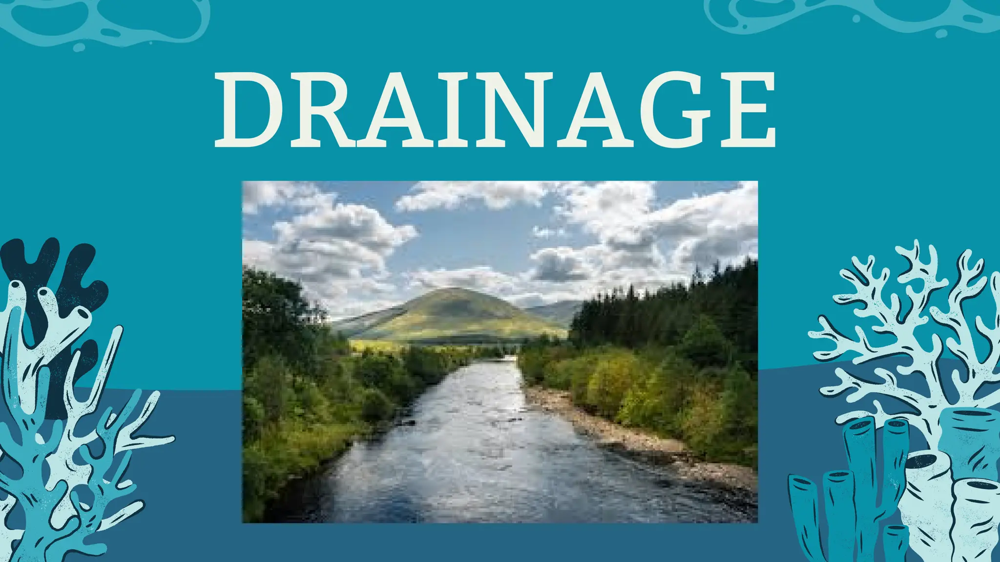
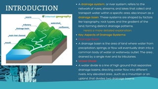
INTRODUCTION
A drainage system,or river system, refers to the
network of rivers, streams, and lakes that collect and
transport water within a specific area, also known as a
drainage basin. These systems are shaped by factors
like topography, rock types, and the gradient of the
land, forming distinct drainage patterns.
Here's a more detailed explanation:
Key Aspects of Drainage Systems:
Drainage Basin:
A drainage basin is the area of land where water from
precipitation, springs, or flow will eventually drain into a
common body of water or waterway outlet. The area ,
drained by a single river and its tributaries.
Water Divide:
A water divide is a line of high ground that separates
drainage basins, directing water flow into different
rivers. Any elevated area , such as a mountain or an
upland ,that divides two drainage basins.
3.
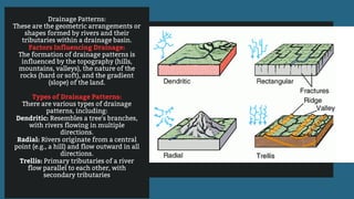
Drainage Patterns:
These arethe geometric arrangements or
shapes formed by rivers and their
tributaries within a drainage basin.
Factors Influencing Drainage:
The formation of drainage patterns is
influenced by the topography (hills,
mountains, valleys), the nature of the
rocks (hard or soft), and the gradient
(slope) of the land.
Types of Drainage Patterns:
There are various types of drainage
patterns, including:
Dendritic: Resembles a tree's branches,
with rivers flowing in multiple
directions.
Radial: Rivers originate from a central
point (e.g., a hill) and flow outward in all
directions.
Trellis: Primary tributaries of a river
flow parallel to each other, with
secondary tributaries
4.
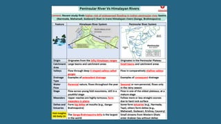
Drainage System inIndia
The drainage systems
of India are mainly
shaped by the large
landforms of the
subcontinent. The Indian
rivers can be divided into
two main categories:
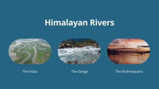
The Himalayan Rivers
The Peninsular Rivers
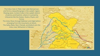
The Indus risesin Tibet, near Lake Mansarovar,
and forms a beautiful gorge in the Ladakh region.
Flowing west, it enters India in the Ladakh district
of Jammu and Kashmir, where it is joined by
tributaries like the Zaskar, Nubra, Shyok, and
Hunza.
The Indus flows through Baltistan and Gilgit before
emerging from the mountains at Attock.
The Satluj, Beas, Ravi, Chenab, and Jhelum join the
Indus near Mithankot in Pakistan.
9.
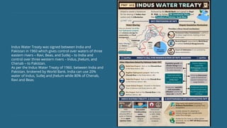
Indus Water Treatywas signed between India and
Pakistan in 1960 which gives control over waters of three
eastern rivers – Ravi, Beas, and Sutlej – to India and
control over three western rivers – Indus, Jhelum, and
Chenab – to Pakistan.
As per the Indus Water Treaty of 1960. between India and
Pakistan, brokered by World Bank. India can use 20%
water of Indus, Sutlej and Jhelum while 80% of Chenab,
Ravi and Beas.
10.
THE GANGA
RIVER SYSTEM
Listof Tributaries of Ganga River
Right Bank Tributaries of Ganga
Yamuna River
Son River
Some other minor right bank tributaries include the Chambal, Ken, Betwa, and Sind Rivers –
all of which are tributaries of the Yamuna River
Left Bank Tributaries of Ganga
Ramganga River
Ghaghra River
Kali River
Gandak River
Burhi Gandak
Kosi River
The Brahmaputra risesin Tibet, east of Mansarovar
Lake. It is slightly longer than the Indus and flows east
alongside the Himalayas.
Upon reaching Namcha Barwa (7757 m), it makes a ‘U’
turn and enters India in Arunachal Pradesh through a
gorge, where it is known as the Dihang. It is joined by
the Dibang, Lohit, and many other tributaries, forming
the Brahmaputra in Assam.
In India, it flows through a high rainfall area, carrying a
large volume of water and significant amounts of silt.
The Brahmaputra has a braided channel throughout
Assam, creating many river islands, with Majuli being
the largest inhabited river island in the world.
During the monsoon season, the river can overflow its
banks, causing extensive flooding in Assam and
Bangladesh. The riverbed accumulates large amounts
of silt, which can raise the riverbed and shift its channel
frequently.
14.
Origin: Chemayungdung glacierin the Kailash
range near Mansarovar Lake
In southern Tibet, it is known as the Tsangpo.
Rango Tsangpo serves as the major right-bank
tributary in Tibet.
Namcha Barwa: it takes a ‘U’ turn and enters India
as Dihang.
It enters Assam Plains near Sadiya from where it is
known as Brahmaputra.
Enters Bangladesh: near Dhubri.
In Bangladesh, it is joined by Tista (right bank),
after which it is called Jamuna.
Padma: When it merges with Ganga, it is known as
Padma.
Meghana: After the Padma river is joined by
Meghana River, it is collectively known as
Meghana.
Brahmaputra Basin: Its basin is spread over the
states of Arunachal Pradesh, Assam, West Bengal,
Meghalaya, Nagaland and Sikkim.
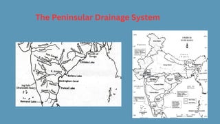
The Peninsular drainagesystem is older than the Himalayan drainage
system. This is shown by the wide, mostly flat valleys and the well-
developed rivers. Peninsular rivers have a fixed path, do not
meander, have small drainage areas, and flow non-continuously.
The main water divide in Peninsular India is formed by the Western
Ghats, which stretch from north to south near the western coast.
Most major rivers in this region, such as the Mahanadi, Godavari,
Krishna, and Kaveri, flow eastwards into the Bay of Bengal and form
deltas at their mouths. Additionally, there are many small streams
flowing west of the Western Ghats. The Narmada and Tapi are the
only long rivers that flow westward and create estuaries. The
drainage basins of these rivers are generally smaller compared to
those of the Himalayan rivers.
17.
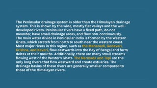
The Narmada Basin
TheNarmada begins in the Amarkantak hills of
Madhya Pradesh at a height of about 1,057 m. It
flows westwards through a rift valley formed by
faulting and empties into the Arabian Sea south of
Bharuch.
It is the largest west flowing river of the peninsular
region flowing through a rift valley between the
Vindhya (north) and the Satpura Range (south).
The Sardar Sarovar Project has been built on this
river. Along its route to the sea, the Narmada creates
many scenic spots, including:
Marble Rocks near Jabalpur, where the river flows
through a deep gorge.
Dhuadhar Falls, where the river cascades over steep
rocks.
The Narmada basin covers parts of Madhya Pradesh
and Gujarat.
All the tributaries of the Narmada are very short.
Most of the tributaries join the Narmada at right
angles.
18.
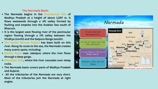
The Tapi Basin
TheTapi originates
in the Satpura
ranges in the Betul
district of Madhya
Pradesh. About 79
percent of its basin
is in Maharashtra, 15
percent in Madhya
Pradesh, and 6
percent in Gujarat.
The Tapi flows in a
rift valley parallel to
the Narmada but is
shorter.
19.
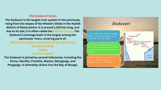
The Godavari Basin
TheGodavari is the largest river system in the peninsula,
rising from the slopes of the Western Ghats in the Nashik
district of Maharashtra. It is around 1,500 km long, and
due to its size, it is often called the Dakshin Ganga. The
Godavari's drainage basin is the largest among the
peninsular rivers, covering parts of:
Maharashtra (about 50 percent of the basin area)
Madhya Pradesh
Odisha
Andhra Pradesh
The Godavari is joined by several tributaries, including the
Purna, Wardha, Pranhita, Manjra, Wainganga, and
Penganga. It ultimately drains into the Bay of Bengal.
20.
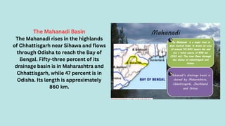
The Mahanadi Basin
TheMahanadi rises in the highlands
of Chhattisgarh near Sihawa and flows
through Odisha to reach the Bay of
Bengal. Fifty-three percent of its
drainage basin is in Maharashtra and
Chhattisgarh, while 47 percent is in
Odisha. Its length is approximately
860 km.
21.
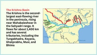
The Krishna Basin
TheKrishna is the second-
largest east-flowing river
in the peninsula, rising
near Mahabaleshwar in
the Sahyadri range. It
flows for about 1,400 km
and has several
tributaries, including the
Tungabhadra, Koyana,
Ghatprabha, Musi, and
Bhima
22.
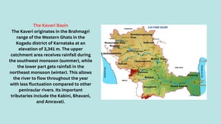
The Kaveri Basin
TheKaveri originates in the Brahmagri
range of the Western Ghats in the
Kogadu district of Karnataka at an
elevation of 3,341 m. The upper
catchment area receives rainfall during
the southwest monsoon (summer), while
the lower part gets rainfall in the
northeast monsoon (winter). This allows
the river to flow throughout the year
with less fluctuation compared to other
peninsular rivers. Its important
tributaries include the Kabini, Bhavani,
and Amravati.
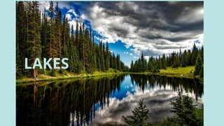
Category of Lakein
India
1. Freshwater Lakes
2. Saltwater Lakes
3. Natural Lakes
4. Oxbow Lakes
5. Artificial Lakes
6. Crater Lakes
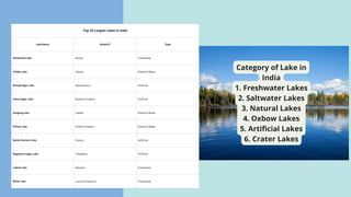
Top 10 Largest Lakes in India
Lake Name State/UT Type
Vembanad Lake Kerala Freshwater
Chilika Lake Odisha Brackish Water
Shivaji Sagar Lake Maharashtra Artificial
Indira Sagar Lake Madhya Pradesh Artificial
Pangong Lake Ladakh Brackish Water
Pulicat Lake Andhra Pradesh Brackish Water
Sardar Sarovar Lake Gujarat Artificial
Nagarjuna Sagar Lake Telangana Artificial
Loktak Lake Manipur Freshwater
Wular Lake Jammu & Kashmir Freshwater
25.
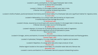
Wular Lake:
Located inJammu and Kashmir, it's the largest freshwater lake in India.
Known for its diverse fish and birdlife.
2. Chilika Lake:
Located in Odisha, it's the largest brackish water lake in India.
A Ramsar site and a popular birdwatching location.
3. Kolleru Lake:
Located in Andhra Pradesh, positioned between the Krishna and the Kaveri delta; it's a freshwater lake and a significant habitat for migratory birds.
4. Lunar Lake:
Located in Maharashtra, it's a unique crater lake formed by an impact event.
A notified National Geo-heritage Monument.
5. Vembanad Lake:
Located in Kerala, reowned as an tourist spot with coconut islands; it's the largest lake in India by area.
A Ramsar site and a major source of drinking water.
6. Loktak Lake:
Located in Manipur, it's known for its floating islands (phumdis) made of vegetation.
A Ramsar site and a significant source of hydroelectric power.
Other important lakes:
Dal Lake:
Located in Srinagar, Jammu and Kashmir, it's known for its picturesque shikaras (traditional boats) and floating gardens.
Hussain Sagar Lake:
Located in Hyderabad, Telangana, it's a man-made lake used for irrigation and recreation.
Sambhar Lake:
Located in Rajasthan, it's a large saline lake and a major producer of salt.
Pulicat Lake:
Shallow lagoon located on the coast of Tamil Nadu, it's a brackish water lake and a Ramsar site.
Manasbal Lake:
Located in Jammu and Kashmir, it's a freshwater lake and a popular birdwatching location.
26.
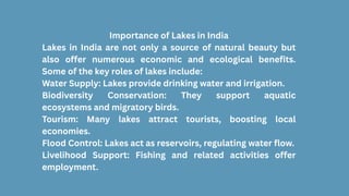
Importance of Lakesin India
Lakes in India are not only a source of natural beauty but
also offer numerous economic and ecological benefits.
Some of the key roles of lakes include:
Water Supply: Lakes provide drinking water and irrigation.
Biodiversity Conservation: They support aquatic
ecosystems and migratory birds.
Tourism: Many lakes attract tourists, boosting local
economies.
Flood Control: Lakes act as reservoirs, regulating water flow.
Livelihood Support: Fishing and related activities offer
employment.
27.
Rivers play acrucial role in the economy by providing water for various
essential activities like irrigation, drinking, and hydropower generation. They
also facilitate transportation and trade, support fishing and tourism, and
contribute to overall economic growth.
Specific Economic Roles:
Agriculture:
Rivers provide water for irrigation, which is vital for food production, especially
in agricultural-dependent countries like India.
Energy:
Rivers are harnessed for hydroelectric power generation, providing a renewable
energy source.
Transportation:
Rivers are used for navigation and trade, facilitating the movement of goods
and people.
Fishing:
Rivers support fishing industries, providing a source of food and income for
many communities.
Tourism:
Rivers attract tourists for various activities like boating, kayaking, and wildlife
viewing, contributing to local economies.
Water Supply:
Rivers are a primary source of freshwater for drinking, sanitation, and industrial
use.
Waste Management:
Rivers can be used for the disposal of waste and pollutants, but this also poses a
risk to their health.
Ecosystem Services:
Rivers provide a variety of ecosystem services, such as flood control, water
purification, and habitat for various species.
ROLE OF RIVERS IN ECONOMY
28.
The increasing demandfor water from rivers due to domestic,
municipal, industrial, and agricultural needs is impacting water quality.
This demand leads to more water being taken from rivers, which
decreases their flow.
At the same time, untreated sewage and industrial waste are being
discharged into these rivers.
This not only deteriorates water quality but also reduces the river's
ability to cleanse itself.
For instance, when there is enough water flow, the Ganga can dilute and
manage pollution within 20 km of large cities.
However, growing urban and industrial activities obstruct this natural
process, resulting in higher pollution levels in many rivers.
The rising pollution levels have prompted the initiation of various
action plans aimed at cleaning the rivers.
Worries about rising pollution in our rivers have led to the start of
various action plans aimed at cleaning them, such as the Ganga Action
Plan (GAP) initiated in 1985 and the National River Conservation Plan
(NRCP) expanded in 1995. The aim of the NRCP is to improve the water
quality of rivers, which are major water sources in the country, through
pollution control measures
RIVER
POLLUTION
29.
The National RiverConservation Plan (NRCP)in 1995 is a centrally sponsored
scheme in India aimed at reducing pollution in rivers by implementing pollution
abatement works. It focuses on improving water quality through measures like
sewage interception and diversion, and building sewage treatment plants,
according to the NRCD. The NRCP complements state government efforts and
provides financial assistance, according to the government of India.
Key features of the NRCP:
Objective: Reduce pollution in rivers and improve water quality.
Focus: Interception and diversion of sewage, construction of sewerage systems,
and setting up of sewage treatment plants.
Scope: Pollution abatement works in identified river stretches across the country,
excluding the Ganga basin.
Implementation: On a cost-sharing basis between the central and state
governments.
Monitoring: Central Pollution Control Board (CPCB) and State Pollution Control
Boards/Committees monitor water quality through a network of monitoring
stations.
Currently , pollution control projects are active in 57 towns, with 215 initiatives
approved.
So far,69 of these initiatives have been completed ,with the goal of intercepting,
diverting , and treating one million litres of sewage.
THE NATIONAL RIVER CONSERVATION PLAN
30.
The Ganga ActionPlan (GAP), initiated in 1986, aimed to address the
pollution of the Ganges River by intercepting, diverting, and treating
sewage and industrial waste. It was a 100% centrally sponsored
scheme directed by the then Prime Minister, Rajiv Gandhi, with the
Ministry of Environment and Forests (MoEF) overseeing its design and
implementation. The plan was divided into two phases, with the first
phase focusing on Uttar Pradesh, Bihar, and West Bengal.
Key aspects of the Ganga Action Plan:
Objectives:
The primary goal was to improve the water quality of the Ganges by
reducing pollution load and preventing further contamination.
Phases:
Phase I (1985): Covered the states of Uttar Pradesh, Bihar, and West
Bengal.
Phase II (1993): Expanded to include seven states: Uttarakhand, Uttar
Pradesh, Bihar, Jharkhand, West Bengal, Delhi, and Haryana, and also
included tributaries like Yamuna, Gomti, and Mahananda.
GANGA ACTION PLAN
31.
The world’s largestdrainage basin is the River Amazon
which is situated in South America.
According to the regulation of the Indus Water Treaty
(1960), India can use only 20 per cent of the total water
carried by the Indus River system. This water is used for
irrigation in the Punjab, Haryana, and the southern and
western parts of Rajasthan.
The Sundarban Delta derived its name from the Sundari
tree which grows well in marshland. it is the world’s
largest and fastest-growing delta. it is also the home of
the Royal Bengal Tiger.
The Brahmaputra is known as the Tsang Po in Tibet and
Jamuna in Bangladesh.
The river Kaveri is the second biggest waterfall in India.
it is known as Sivasmudram. the fall supplies
hydroelectric power to Mysore, Bangalore, and the
Kolar Gold Field.
71 percent of the world’s surface is covered with water,
but 97 percent of that is saltwater. Of the 3 percent that
is available as freshwater, three-quarters of it is trapped
as ice.
Lakes of large extent are called the seas, like the
Caspian, the Dead, and the Arab seas.
Some
Interesting
Knowledge
32.
Difficult Words
Drainage Basin:The area drained by a single river system where precipitation collects and
drains off into a common outlet, such as into a river, bay, or other body of water.
Tributary: A river or stream flowing into a larger river or lake.
Water Divide: An elevated area, such as a mountain or upland, that separates two
drainage basins.
Rift Valley: A large elongated depression with steep walls formed by the downward
displacement of a block of the earth's surface between nearly parallel faults or fault
systems.
Braided Channel: A network of river channels separated by small, often temporary,
islands called braid bars. These typically form in rivers with high sediment loads and
strong currents.
Riverine Island: An island formed by the course of a river. Majuli in the Brahmaputra River
is an example of such an island.
Alluvial Soil: Soil deposited by rivers. It is typically fertile and good for agriculture.
Peninsular Plateau: A plateau in India making up the majority of the southern part of the
country. It is bordered by two mountain ranges, the Eastern and Western Ghats.
Sundarban Delta: The large delta formed at the mouth of the Ganges and Brahmaputra
River systems. It is noted for its wide mangrove forests and is home to the Royal Bengal
Tiger.
Indus Water Treaty: A water-distribution treaty between India and Pakistan, brokered by
the World Bank, to use the water available in the Indus River and its tributaries.