Downloaded 21 times

![w w w . g e o t a b . c o . z a
REAL TIME LOCATION
It’s as simple as clicking on the vehicle in question and requesting ‘Show on Map’
and the vehicle in question is displayed on the map. Should the requirement be to
view the data live a further click on ‘Live’ and the vehicle data is displayed live, as
it comes into the Checkmate™ database.
Trip History is stored in Checkmate™ for you to recreate trips for historic analysis if
required. Trips can be displayed on a range of map choices to suit your needs. When
using Geotab™ Driver ID keys, trips can be shown for fleets or individual drivers.
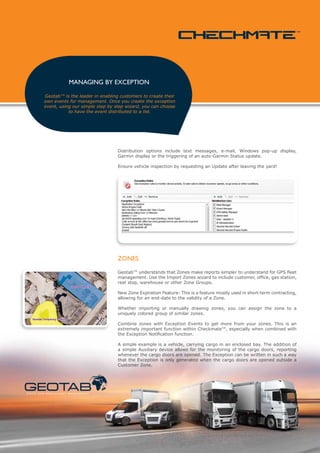
For fleet operations with multiple groups – EMS, public works, utility or large
corporates each vehicle is assigned to a unique group. All fleets are maintained in
a single Checkmate™ database.
To quickly identify needed assets, the end-user makes use of the Highlight Groups
feature. Every fleet vehicle sends a daily heartbeat [including battery voltage] so
you can account for the health of all vehicles.
CS41 on Tuesday, July 06, 2011 at 9:01:24 AM for 26m46s in Geotab Parking
Zone Stopped
Administration, All, Mobile - On Call, North Region
s tat i c a n d m o b i l e a s s e t m a n a g e m e n t](https://image.slidesharecdn.com/checkmatelorez-13347385920792-phpapp01-120418034637-phpapp01/85/Checkmate-Geotab-Software-suite-3-320.jpg)
![on-the-fly routing
Using our Garmin integration, it is a simple process to
route a vehicle directly to an address. Added functionality
caters for allocating a route to the nearest available vehicle
while it’s driving, allowing for almost-instant reaction to
changing circumstances during the working day.
If dispatch needs an update, they can send a status update request to a single
vehicle [or multiple vehicles] directly from Checkmate™
Of course, with Garmin the ability to route a Driver to a specific address is an impor-
tant feature. Geotab™ has written the functionality into Checkmate™ that allows
dispatch to enter a number of predetermined stops [or Zones within Checkmate™]
and send this data to the vehicle directly.
On receipt of the data the Garmin device plans the route and displays the various
stops for the Driver. It is then a simple acknowledgement by the Driver that he ac-
cepts the route and the Garmin directs the Driver in line with the calculated route.
Checkmate™ will report deviation from the planned route.
message tracking
Messages can be sent to a single vehicle, a group, or all vehicles.
Once sent, the GPS Text Messages screen in Checkmate™ will show dispatch the time
when the message was read by the Driver – and the time when the Reply was sent.
s tat i c a n d m o b i l e a s s e t m a n a g e m e n t](https://image.slidesharecdn.com/checkmatelorez-13347385920792-phpapp01-120418034637-phpapp01/85/Checkmate-Geotab-Software-suite-4-320.jpg)
![w w w . g e o t a b . c o . z a
precise trip recording
The Geotab™ devices record trip data using X-Act™, our patented Intelligent Log-
ging Processor. This gives the fleet owner the highest possible trips resolution at
the lowest GPRS cost.
Turns, stops and speeds are captured to recreate fleet trips with precision.
Nick Hart in SH 685 6RK on Tuesday, July 06,2011 at 9:24:25 AM for 21m31s
in Ontare Zone
Stopped
SH 685 6RK
All, North Region, Second Harvest
Accuracy is the guiding principle of Geotab’s offering, it is our belief that you cannot
manage fleets of vehicles unless the data is of a standard that can be upheld in a
court of law.
In a recent independent test a trip using a standard Geotab™ device a trip accuracy
of over 99.9% was recorded [Geotab™ recorded distance versus the actual distance
of the route travelled].
To date we have represented our Customers in both the Labour Courts of South
Africa and the CCMA on innumerable occasions as an Independent Expert. This is
an added value service we offer to our Customers.
x-act
™
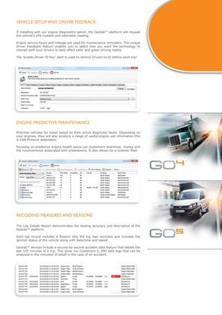
daily vehicle health check
The automatic Vehicle Health Check includes an easy to analyse diagnostic. With
the daily heartbeat feature, the system can alert fleet managers to vehicles that are
reporting heartbeats but are not being driven, identifying under-utilised vehicles in
the fleet.
Note that it is useful to Group vehicles by territory, work type and other categories
for summary reporting.](https://image.slidesharecdn.com/checkmatelorez-13347385920792-phpapp01-120418034637-phpapp01/85/Checkmate-Geotab-Software-suite-5-320.jpg)

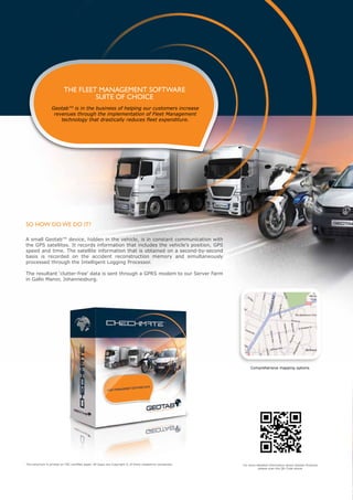
Fleet management software from Geotab uses small devices in vehicles to track location data like position, speed and time. This data is sent via GPRS to Geotab's server farm for analysis. The software allows users to view vehicles in real-time or historically, send messages to vehicles, plan routes, and monitor engine health for predictive maintenance. Geotab's accurate tracking capabilities make it suitable for managing fleets and being used as expert evidence in legal cases.


