Download to read offline


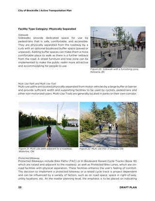
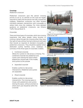
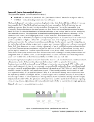
![City of Brockville | Active Transportation Plan
DRAFT PLAN 28
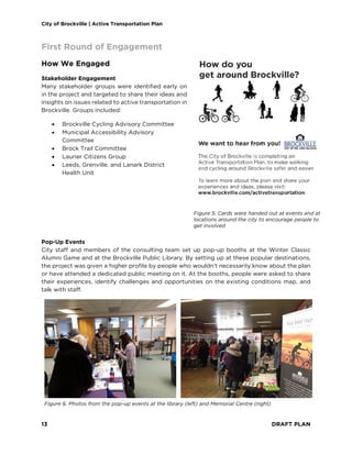
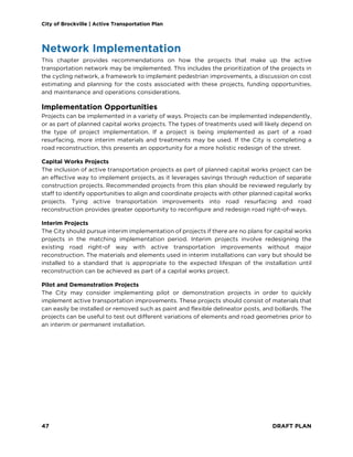
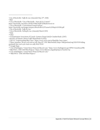
What We Heard
Throughout the first round of public engagement, we
heard that many people are already walking and cycling to
get around the City. People are walking and cycling to go
to work or school, get groceries, see friends, or for
recreation. While some people are using active
transportation already, they acknowledged that there is a
need for improvement as many roads and crossings in
Brockville are not comfortable to bike on and gaps in the
sidewalk network discourage walking.
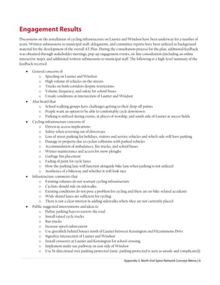
Themes
The following themes were heard throughout the
engagement process.
Destinations
• Downtown – Many people identified
destinations throughout the downtown area
that they like to walk and cycle to, including
the library, arts centre, restaurants, and cafes
• Mac Johnson Wildlife Area – Many people
commented that it is challenging to get to the trails in the wildlife area as there is no
connection on or across Centennial Road, or connection from the Brock Trail
• Parkedale Avenue – This corridor was identified as a destination for many people, with
many stores, the movie theatre, Thousand Islands Secondary School, and St. Lawrence
College
Barriers
• Speeding traffic – Vehicles going too fast, creating a stressful environment to walk and
cycle in, was identified on roads throughout Brockville
• Lack of infrastructure – Many people identified places they would like to go, but they
feel unsafe doing so due to the lack of infrastructure for cycling
• Spot gaps – Numerous locations were identified as being inaccessible or unsafe to use,
whether it is due to bollards, poor maintenance, drainage issues, or lack of infrastructure,
such as desired crossing locations
• Winter maintenance – People feel unsafe or unable to walk and cycle in Brockville during
the winter season due to inadequate winter maintenance
Many of the site-specific barriers were added to the Gap analysis.
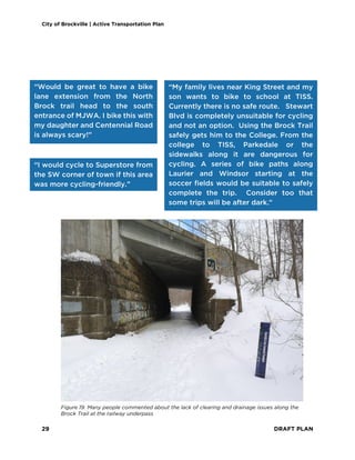
“I live in this neighbourhood
[north end] and would LOVE
to bike to work downtown,
but I don't feel safe without
bike lane development.”
“I use this route [Brock Trail] to
walk to work from Pearl Street
West to downtown, it is a lovely
walk and I really appreciate
having the trail as a commuting
option.”](https://image.slidesharecdn.com/brockville-active-transportation-full-plan-240229214230-8a558d4b/85/Brockville-Active-Transportation-Full-Plan-pdf-30-320.jpg)
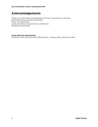
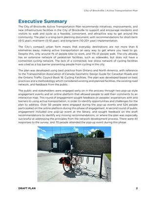
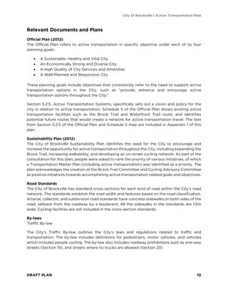
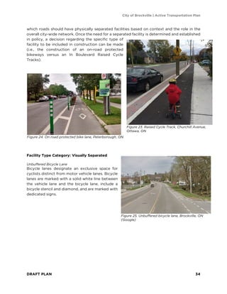
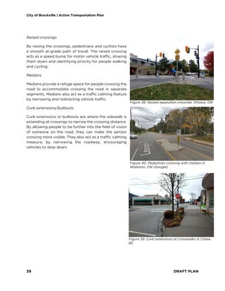
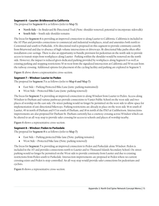
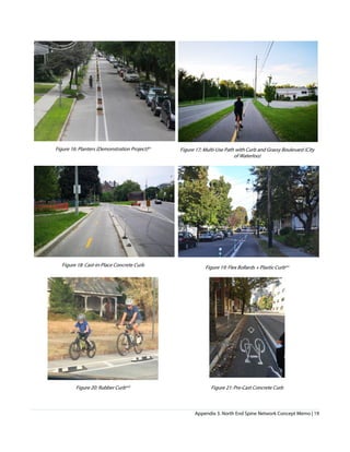
![City of Brockville | Active Transportation Plan
DRAFT PLAN 30
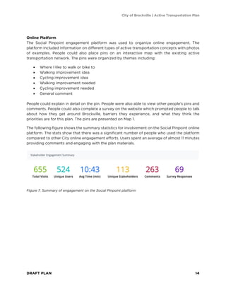
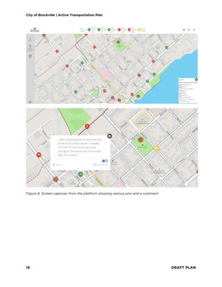
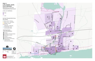
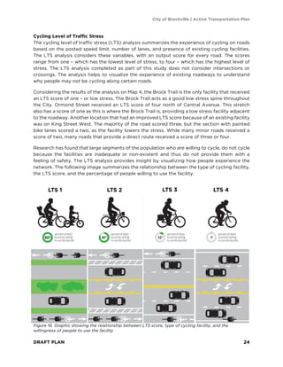
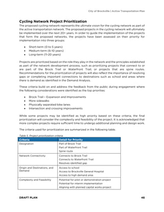
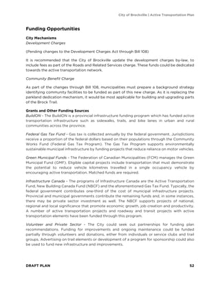
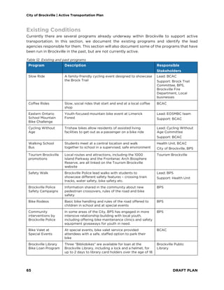
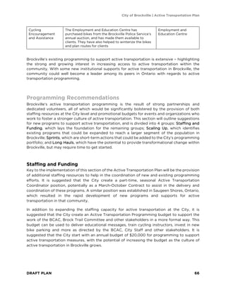
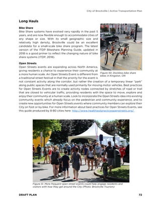
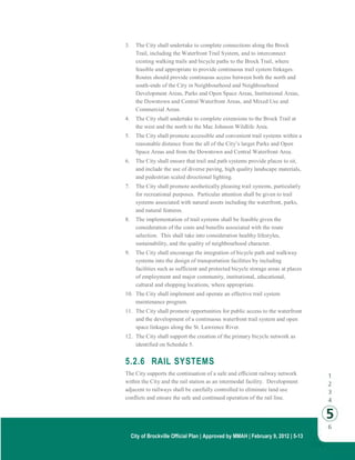
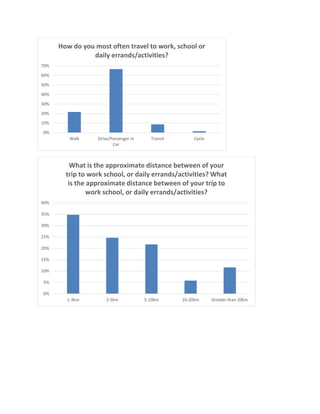
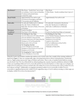
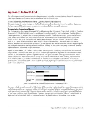
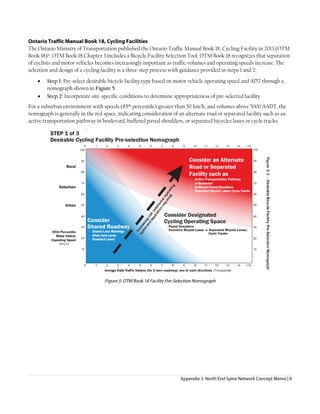
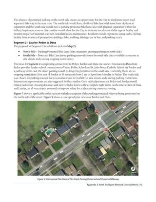
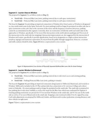
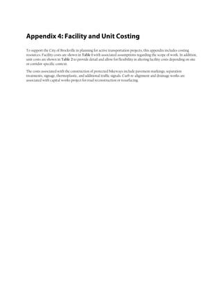
Survey Results
The survey on the online platform asked important questions regarding the direction and goals
of this plan. The responses to those questions are shown below. What they show is a strong
desire for the expansion of walking and cycling infrastructure that can be used by all ages and
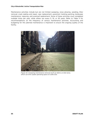
abilities. Improving maintenance is another priority identified through these questions. The
complete results from the survey can be found in Appendix 2. A sample of survey results are
provided below.
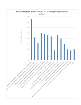
The top 5 themes that were identified as an important part of this vision were:
1. Needs for people of all ages and abilities to walk/bike around Brockville
2. Bike lanes and sidewalks that are located where people need to go
3. More options for walking, cycling, transit in a way that works together
4. More of a focus on bike lanes and sidewalks that are swept or winter cleared
5. Create opportunities for people to use the active transportation network year round
The top 3 focuses of this plan were identified as:
1. Expanding network - proposing new walking and cycling facilities throughout the City
of Brockville
2. Connectivity - enhancing connectivity and crossings of existing facilities
3. Maintenance - providing recommendations for maintenance of existing trails
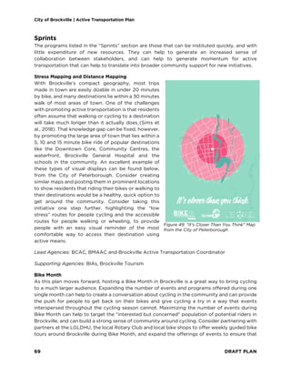
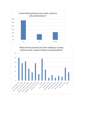
0
5
10
15
20
25
30
What network upgrades should be the top priorities for
Brockville [select up to three]:](https://image.slidesharecdn.com/brockville-active-transportation-full-plan-240229214230-8a558d4b/85/Brockville-Active-Transportation-Full-Plan-pdf-32-320.jpg)

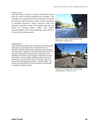

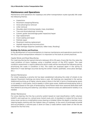
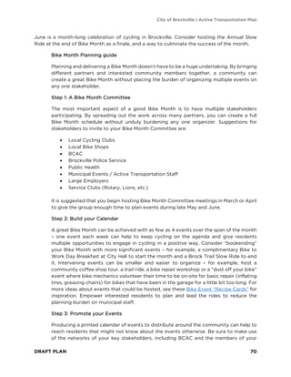
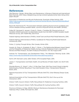
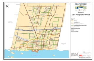

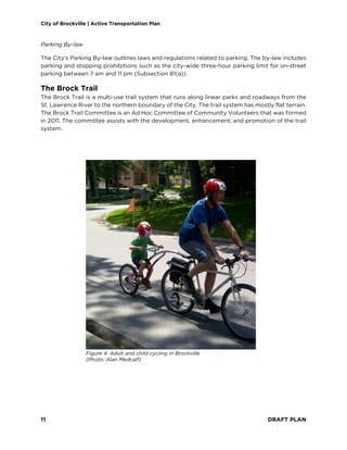
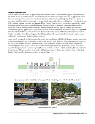
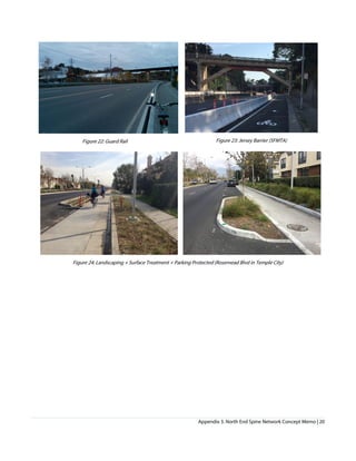
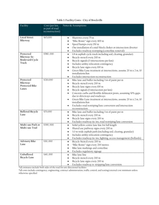
![0
5
10
15
20
25
30
What network upgrades should be the top priorities for
Brockville [select up to three]:](https://image.slidesharecdn.com/brockville-active-transportation-full-plan-240229214230-8a558d4b/85/Brockville-Active-Transportation-Full-Plan-pdf-87-320.jpg)

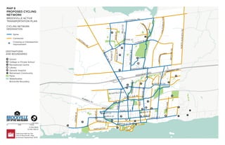
This document is a draft active transportation plan for the City of Brockville. It recommends initiatives to encourage walking and cycling through new infrastructure like bike routes. The plan was developed with public input, which identified a lack of connected cycling routes as a key barrier. It proposes a cycling network with 42 km of "spine routes" and 39 km of "connector routes" along with pedestrian improvements. The plan also provides policy, funding, maintenance and programming recommendations to promote active transportation long-term.


