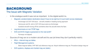
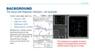
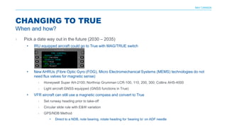
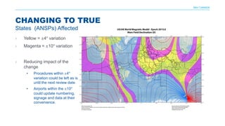
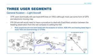
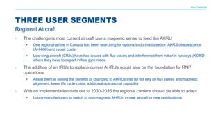
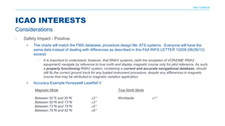
An ECDIS is an electronic system that can display navigational charts and position information to serve as an alternative to paper charts. It integrates data from GPS, radar, and AIS to determine a vessel's position in relation to land, hazards, and navigation aids. The IMO requires all ships to carry electronic charts and ECDIS to meet chart carriage requirements. When planning a passage using ECDIS, the navigator must ensure the vessel has up-to-date chart licenses, enter vessel parameters, set the safety contour and domain, and create a route by placing waypoints while checking for hazards. ECDIS is then used during the voyage to monitor position and trigger alarms if safety parameters are exceeded.
ECDIS: New standards & old underwater rocksLearnmarine
Webinar on: IHO S-52 Presentation Library 4.0, ECDIS as an anti-grounding device, Safety Contour and Safety Depth setup, information layers, utilities.
This document summarizes the assessment of navigation infrastructure to support area navigation (RNAV). It discusses the requirements for RNAV performance and the suitable ground-based and space-based infrastructure needed to meet those requirements. It also reviews the current navigation infrastructure, including VOR, DME, NDB and GPS, and assesses issues with coverage, performance, costs and potential outages. It outlines the target navigation strategy and infrastructure evolution by 2015, focusing on multisensor options and rationalizing ground infrastructure while developing space-based systems like GPS and Galileo.
A brief description of how the PBN/RNAV concept works, together with an update of the FAA implementation programs for it in the US. This presentation has been made using public information only.
This document discusses ADS-B (Automatic Dependent Surveillance - Broadcast), a technology that will replace radar as the primary means for air traffic controllers to track aircraft. It operates using two modes: ADS-B Out broadcasts data from aircraft, while ADS-B In receives data in the aircraft. By 2020, all aircraft will be required to have ADS-B Out equipment installed. ADS-B uses GPS and broadcasts aircraft's location, speed, and other data to any aircraft or ground station equipped to receive it. This allows pilots and controllers to see the same information simultaneously.
APACHE 4 AUTONOMOUS HYDROGRAPHIC SURVEY USV CALL/ WA 082119953499Budi anto
Hubungi Kami : PT. MINDS INDO SURVEY
Komp. Ruko Mega Kalimalang Kav.8 No.11
Jln.KH.Noer Ali Pekayon Jaya Bekasi 17148
Tlp : 02188860786, Fax : 02188860790
Mobile : 082119953499/ 081388802423
Email : budi1080@gmail.com
RUANG LINGKUP KEGIATAN
PENJUALAN, SERVICE / PERBAIKAN DAN PENYEWAAN
ALAT-ALAT UKUR
Penjualan :
• Alat Ukur
- Total Station (baru dan second hand)
- Theodolite (baru dan second hand)
- Levels (baru dan second hand)
- GPS Handheld
- GPS Geodetik
- UAV dan USV
- Compass
- Clinometer
- Tandem
- Altimeter
- Digital Planimeter
- Walking Measure
- Digital Level
- Phantograph
- Laser Tools Spectra
• Accessories :
- Tripod
- Prisma Detail dan Poligon
- Rambu Ukur 3m, 4m, 5m, dan 7m
- Meteran
- Jalon
Layanan Rental :
- Total Station
- Theodolite
- Autolevel
- GPS Geodetik Statik dan RTK
Merek Alat Ukur Yang Tersedia :
- Nikon
- Sokkia
- Topcon
- Leica
- Spectra
- CHC
- Horizon
- Garmin
- Trimble
- Minds dll.
SERVICE / PERBAIKAN DAN KALIBRASI MACAM-MACAM ALAT UKUR
HARGA MENARIK / COMPETITIVE
Catatan : Price List akan dikirim sesuai permintaan
Contact Person
Budianto
0813 8880 2423
0821 1995 3499
Savannah cruise ship study phase i report presentaion 06-24-13jhayman09
The document summarizes a study evaluating three potential sites for a cruise ship terminal in Savannah, Georgia. Site A has the smallest area but requires the least dredging. Site B requires more dredging but offers less area for ancillary development. Site C requires the most dredging but offers the most space for additional development. All three sites require further environmental review and permitting before being selected. The study provides a framework to evaluate each site based on infrastructure, navigation, dredging needs, and environmental impacts.
This document provides an overview of differential GPS (DGPS) and its history. It explains that DGPS uses fixed, ground-based reference stations to broadcast corrections to improve GPS accuracy from 15 meters to about 10 cm. Selective availability was introduced by the US military to degrade civilian GPS but was turned off in 2000. DGPS was developed as a solution, broadcasting corrections to offset errors and allow 5 meter accuracy, meeting most civilian needs. It has expanded to cover many waterways through systems like the US Coast Guard's National DGPS.
The document outlines 17 performance standards that GPS receiver equipment installed on ships must meet in order to be compliant. The standards require the equipment to:
1) Be capable of receiving and processing GPS signals to provide position, latitude and longitude, in the WGS-84 coordinate system and UTC time within specified accuracies and update rates.
2) Have static and dynamic position accuracy of 100m or less depending on whether differential GPS corrections are applied.
3) Generate and output position, course, speed, and time data at least once per second and interface with other navigation equipment.
4) Provide warnings if performance standards for position dilution or update rates are not met.
Optimizing precision final approach through gbasIrfan iftekhar
Ground-based augmentation systems (GBAS) provide localized precision GPS corrections to aircraft, enabling precision approaches. GBAS has benefits over instrument landing systems like supporting more runways with one system. GBAS also allows for flexible siting, steadier guidance, and less frequent inspections. While GBAS can increase efficiency and capacity, limitations remain such as the need for aircraft and ground infrastructure to support its full capabilities. Airports are working to certify GBAS for low-visibility operations and eventually replace ILS.
1. The purpose of a simplified voyage data recorder (S-VDR) is to securely store information about a vessel's position, movement, status, and command in the event of an incident for use in subsequent investigations.
2. Ships defined in SOLAS Chapter V must be fitted with an S-VDR that continuously records preselected data items relating to ship status, equipment output, and command/control. The data must be time-correlated and stored in a tamper-proof capsule for at least 2 years.
3. An S-VDR must record data items including date, time, position, speed, heading, bridge audio, communications audio, radar data, and AIS data
A330 MRTT Update 2012
These slides were presented during the Trade Media 2012 event held at Madrid, Spain and Toulouse, France in May 2012.
The slides were prepared for presentation by Antonio Caramazana, VP, Head of Airbus Military Derivatives, but he was on travel and not available to give the briefing.
In his stead, Francisco Carrasco, Director RSAF MRTT Program provided the briefing and answered questions.
The briefing provides an overview on the tanker and the status with the launch customers. The non-U.S. market of course is dominated by the A330 MRTT tanker.
This document provides an overview of global positioning systems and flight management systems used in aircraft. It defines key terms and describes the components and functions of GPS, WAAS, INS, barometric altimeters, and how they integrate with an aircraft's flight management system. It explains how GPS and WAAS provide lateral and vertical navigation guidance for different types of instrument approaches, including LNAV, LNAV+V, LNAV/VNAV, LP, and LPV approaches. It also covers requirements, limitations, and safety aspects of using GPS and WAAS for navigation.
The use of remotely operated Autonomous Surface Vehicles (ASV’s) has become easy accessible since the introduction of the Teledyne Oceanscience Z-Boat, a versatile solution for a wide range of applications. In this session we will take a closer look at the various hydrographic applications and the advantages of using an unmanned system.
This document provides a historical overview of avionics systems in business jet aircraft cockpits, ending with a review of Dassault Falcon cockpits from 1965 to present. It begins by defining avionics as aviation electronics and describes the role of early avionics such as basic instruments. The document then reviews the evolution of key avionics components like airspeed indicators and flight management systems. Finally, it highlights the avionics suites installed on different Falcon models from the Falcon 20 to the Falcon 7X.
1. The document outlines 23 performance standards that autopilot and heading control systems installed on ships must meet according to the International Maritime Organization (IMO).
2. The standards require systems to reliably maintain a preset heading under various operating conditions, incorporate controls to adjust for weather and steering performance, and allow for easy and safe operation.
3. Systems must also ensure the ship's heading can only be altered intentionally by crew, integrate properly with navigation systems, and include alarms and indications for failures or off-heading situations.
An Update on the Airbus Military Tanker, May 2013ICSA, LLC
During the Airbus Military Trade Media Briefing 2013, held on May 29th and 30th 2013, Antonio Caramazana, head of Airbus Military Derivatives Programs, provided an update on the A330MRTT program.
The platform is now in service with four air forces in the world, Europe, the Middle East and Asia. It is a clear global program.
The document provides a status update on flight testing of the A400M aircraft as of May 16, 2012. It reports that a total of 3,212 flight hours have been completed across 5 aircraft, with 1,094 total flights. The update summarizes achievements across various flight test areas, including crosswind testing, high altitude flights, air-to-air refueling contacts, and demonstration tours in Asia. Major objectives for 2012 include testing of military systems and operations from grass runways.
This document summarizes a student aircraft design project to design a cargo plane. The objectives are to design a cargo plane to carry 600,000 kg over 4,000 km with a cruise speed of 850 km/h. The preliminary design was completed and included collecting comparative data, selecting parameters, estimating weights, selecting engines and airfoils, and creating a wing layout. Structural analysis was performed on the wing and fuselage.
Trajectory estimation studies for long coasting phase of mars missioneSAT Journals
Abstract At Sriharikota range, configuration of down range tracking network, Real-time tracking and trajectory estimation play a critical role during a satellite launch for flight safety as well as mission monitoring. Criticality is more when the mission parameters vary during the launch window to meet the mission requirements. PSLV-C25, the 320 T XL version is intended to inject the 1337.24 Kg MARS Orbiter into 250 Km * 23500 Km * 19.2 deg Sub-GTO orbit. MARS Orbiter Mission [MOM] is the first Indian interplanetary mission to orbit a spacecraft around MARS in an elliptical orbit of 360km * 80000 km. This paper deals with the trajectory estimation and prediction methodologies studied and established at Sriharikota Range for this launch. The major challenge in the Mars orbiter mission is to configure the Down range network of Telemetry stations in view of large variation in the Argument of Perigee (AOP) requirement ranging from 2760 to 2890 during injection over the period of launch window. Requisite AOP facilitates transit of the Spacecraft from Earth to Mars using minimum energy Hohmann transfer. The change in the requirement of AOP each day in turn demanded a new trajectory with its characteristic changes in long coasting duration, fourth stage ignition time and subsequent MARS Orbiter injection time into sub-GTO. It is mandatory to capture the Telemetry data during those critical events to assess the success of the mission. The flight duration was around 3000s and the coasting duration was 1600s before the ignition of the PS4 stage. Study of configuration of mobile Telemetry stations on Ship-borne terminals is carried out to cater to visibility requirements of critical events such as fourth stage ignition time and subsequent MARS Orbiter injection. State vector accuracy studies are carried out for the Ship-borne radar data of the vehicle during long coasting using Linear Kalman filter. Also a trajectory extrapolation algorithm is designed and studied to provide extrapolated trajectory during the long coasting period after 3rd stage burn out which in turn is used to compute and display trajectory parameters to mission executives and provide antenna-pointing information to the ship-borne terminals. This paper presents the trajectory estimation methodology proposed, extrapolation techniques adopted and accuracies achieved for the long coast duration. Keywords: Mars Orbiter Mission (MOM), Flight Safety, Trajectory estimation, Network simulations, Argument of Perigee (AOP).
Design & application of cdo for ahmedabad airport within ahmedabad tmaARVIND KUMAR SINGH
ICAO has emphasized on aviation safety, air navigation capacity and efficient environmental protection by strategic objective. ICAO also focused on the development and implementation on PBN, CDO and CCO for sustainable growth of aviation. Global Air Navigation Plan (2013-2028) provides methodology for integrated aviation planning and increased importance of collaborations and partnership among stakeholders. GANP outlined the implementation issues involving the PBN all over the world. In line with ICAO objective, this focuses on CDO procedure at Ahmedabad airport.
Trial CDO has been implemented but no formal procedure for airlines operator has yet been promulgated at various Indian airports including Ahmedabad Airport. Area and Approach are physically located at same place and trained controllers provide these services on rotation basis at Ahmedabad airport. Air Traffic Services provided with surveillance tools. STARs and SIDs were introduced in year 2008 at Ahmedabad Airport. Ahmedabad Airport has medium density traffic of aircraft movement, average 150 schedule aircraft movement per day and approx 75 scheduled arrivals per day. Due to non availability of published procedure limited Continuous Descent Operations are being performed by the arrivals, at Ahmedabad Airport.
This emphasises on analysis of traffic pattern on arrival routes for possible implementation of CDO is existing arrival procedures and study of existing CDO procedure, analysis of cost benefit, fuel efficiency and carbon emission for Ahmedabad airport.
Design & Application of Continuous Descent Operation (CDO) procedure in Ahmedabad TMA for Ahmedabad Airport will provide more efficient airspace & arrival routes, reduction in pilot –controller work load, cost saving to airlines operators and environmental benefits through reduced fuel burn.
With good CDO procedure, initially minimum 65% of arrivals are expected to perform CDO at Ahmedabad leading to saving of cost of operations and carbon emission, in addition to brand and image building of AAI as ANSP at Ahmedabad. The experience gained will also help AAI extend such procedure to other medium to light density traffic airports and subsequently all airports in line with ICAO Guidelines and requirement.
EGS Weight & Balance Services provides aircraft load control and performance engineering services. Led by Managing Director Eric Bahn, EGS has over 20 years of experience in operations management, load control instruction, and aircraft data analysis. Services include consulting, AHM messaging requirements, manual balance chart design, re-weighs, and training to provide customers with higher safety, return on investment, and environmental quality.
The document outlines the aircraft design process from initial requirements definition through detailed design, testing, and certification. It discusses establishing basic and general requirements, conducting feasibility studies, specifying detailed requirements, conceptual and preliminary design phases involving configuration selection, performance modeling, and optimization. Later phases include detailed design, ground and flight testing, and certification to clear the aircraft for intended operations. The process is iterative with frequent trade-offs and refinement of requirements and design.
The document provides an introduction to area navigation (RNAV) systems. It outlines the history of RNAV, beginning in the 1970s with 2D RNAV using VOR/DME positioning. Modern RNAV utilizes GPS and inertial reference units. The key components of an RNAV system include sensors to determine the aircraft's position, an RNAV computer to calculate guidance to follow a desired path based on navigation data, and displays and controls for pilots. Proper integration and redundancy of positioning sensors is important for accuracy and integrity. Standards like ARINC 424 are used to code routes and procedures into RNAV systems.
- AMDAR is an automated aircraft-based observing system that is a component of WMO's WIGOS and GOS observing systems. It provides meteorological data from aircraft in near-real-time to NMHSs and for inclusion on the WMO GTS.
- AMDAR uses existing aircraft sensors and communications to collect parameters like wind, temperature, humidity, and turbulence. The data meets WMO requirements for accuracy and supports aviation operations and numerical weather prediction.
- The roles and responsibilities of the partners involved - WMO, NMHSs, airlines - are defined to establish AMDAR programs, ensure data quality, and maximize the benefits of the additional observations.
Design of the pinpoint landing GNC of Space RiderSENER
Entry, Descent and Landing (EDL) faces several challenges in order to bring safely to vehicle from orbit flying at several km per seconds to rest onto the surface. Rodrigo Haya Ramos, Head of flight systems at SENER Aerospace, presents an overview of Space Rider, the
GNC of the Re-entry Module and in particular of the
parafoil GNC. The requirements are presented and discussed as well as the current status of the parafoil GNC design and simulation results including dispersion analysis. Applicability of the precise landing GNC with parafoil to planetary probes is also discussed.
This document discusses NYK's efforts to optimize fleet operations through energy efficient measures like slow steaming and weather routing. It describes how NYK uses performance monitoring systems and the SEEMP process to continuously improve vessel efficiency. Broadband connectivity allows for real-time weather routing recommendations and model calibration based on actual vessel performance data collected by onboard monitoring systems. The integration of weather routing, monitoring, and broadband aims to reduce uncertainties and further optimize operations, but challenges remain in accurately measuring factors like wave heights and ship motions.
Introduction of Motion Control and requirements of Navigations systems techno...volodymyrgolikov
E-navigation is the harmonized creation, collection, integration, exchange and presentation of maritime information on board and ashore by electronic means to enhance berth-to-berth navigation and related services, for safety and security at sea and protection of the marine environment
The document summarizes the functions and responsibilities of the Airports Authority of India (AAI). It discusses how AAI manages airports and airspace in India. It describes the key roles of AAI in air traffic control, installing and maintaining navigation equipment, developing airport infrastructure, and providing emergency services. The document also provides details about specific navigation aids, radar systems, and communication networks that AAI utilizes to manage air traffic safety.
The document discusses opportunities for aviation safety through improved communication technologies. It notes that while aviation is very safe, accidents still occur when crews face difficulties and lack support. New technologies allow real-time tracking of aircraft and automated transmission of data to help crews, but face institutional barriers. The document argues these technologies could help prevent accidents by providing expert support and awareness of aircraft status.
GSA - Aviation Market Development Officer, Carmen Aguilera presents "GSA EGNOS and Galileo for Aviation" during the Eurocontrol briefing session, @ World ATM Congress, Madrid, 09/03/2016
This document provides an overview of Global Navigation Satellite Systems (GNSS) and their use in aviation. It describes the need for GNSS due to limitations of existing ground-based navigation systems. The key components of GNSS include satellite constellations, aircraft receivers, augmentation systems, and integrity monitoring. Augmentation systems like Aircraft-Based Augmentation System (ABAS), Satellite-Based Augmentation System (SBAS), and Ground-Based Augmentation System (GBAS) are used to enhance GNSS accuracy, integrity, availability and continuity for aviation applications. GNSS enables more efficient flight paths and procedures but also faces challenges around availability, interference and database accuracy.
In this program FAA's Director of NextGen Performance and Outreach, Gisele Mohler, discusses how NextGen initiatives impact general aviation, and how they can enhance safety.
A Review on Longitudinal Control Law Design for a Small Fixed-Wing UAVIRJET Journal
This document reviews various techniques for designing longitudinal control laws for small fixed-wing unmanned aerial vehicles (UAVs). It discusses techniques such as integral sliding mode control, linear quadratic regulator (LQR), Apriltags recognition algorithm with PID control, observer Kalman identification with PID control, root locus method, nonlinear model simulation, and multi-model techniques. These techniques have been applied to problems such as longitudinal guidance, stability augmentation, autonomous landing, and modeling fixed-wing UAV dynamics. The document analyzes the effectiveness and robustness of different proposed control schemes through simulations and comparisons of various techniques.
The document discusses ACARS, an aircraft communications system introduced in 1978 that uses VHF and satellite datalinks to transmit messages between aircraft and ground stations. It allows transmission of operational data like flight plans, maintenance issues, and position reports. While ACARS was a major improvement over prior voice-only systems, its 2400 baud rate is now too slow as data needs grow. Congestion is increasing on the VHF frequencies it uses. The solution is a transition over the next 20 years to newer protocols like ATN and the Internet Protocol that can better handle rising traffic demands.
The document discusses preparations for the mandatory carriage of ECDIS on vessels over 3,000 GT. It provides an overview of the implementation schedule, which requires all vessels over 10,000 GT to have ECDIS installed by 2018. Vessels must have one type-approved ECDIS and suitable backup arrangements, such as a second ECDIS or paper charts. The document also reviews the benefits of ECDIS, such as improved voyage planning and safety, easier chart management, and logging of navigation data. It provides information on electronic chart types, system configurations including single or dual ECDIS, and possibilities for integrating ECDIS with other bridge systems.
This document proposes using existing vessel data and minimal additional investments to generate accurate mathematical models (MM) and computerized fluid dynamics (CFD) simulations to optimize fuel efficiency for ocean-going vessels. It involves collecting data on vessel characteristics and weather conditions to model friction and resistance. The models would calculate the most fuel-efficient routes, speeds, and draft/trim combinations. They could help masters address unusual phenomena and reduce challenges like operating at non-optimal drafts/trims. There is potential for commercial applications to various vessel types and alternative fuels.
AgendaItem3_FINLAND_FINAVIA (ID 11830).pptMariaMarque
This document discusses user requirements for general aviation (GA) pilots in Finland. It notes that GA pilots have a wide range of needs, from light GA to sport aviation. For IFR GA pilots, weather planning is similar to heavier traffic and relies on Terminal Aerodrome Forecasts. VFR flights are often conducted in marginal weather and benefit from detailed route weather information. The document also outlines typical values for GA aircraft and challenges with interpreting weather data from multiple countries for international flights.
The Airport Community Consultative Committee meeting included:
1) A 2017 Q2 update that reviewed arrival and departure statistics from April to June and noted runway rehabilitation work;
2) An update on the Noise Monitoring Terminal program, including proposed new locations for the roving monitor; and
3) A presentation from NAV CANADA on increasing Required Navigation Performance approaches and a proposed trial to alternate weekend departure runways between 17L and 17R to improve balancing.
1. UAV technology has advanced from remotely piloted vehicles in the 1980s to fully autonomous systems today.
2. UAVs are a cost-effective tool for aerial data acquisition, with lower costs than manned aircraft due to cheaper fuel, no pilot expenses, and easy mobility.
3. RIEGL has developed the RiCopter UAV integrated with the VUX-SYS laser scanning system, allowing for accurate and efficient 3D data collection over a wide field of view from UAV platforms.
Gilat is a leading global provider of satellite networking solutions, including for in-flight connectivity (IFC). It has been in business since 1987 and provides full turnkey solutions including equipment, network management, and installation. While IFC was once limited to basic services, advances in technology now allow for streaming video and broadband access on flights. However, commercial viability remains an open question due to costs and passenger usage and demand patterns. Gilat offers a complete IFC portfolio including antennas, modems, and network management to enable both Ku and Ka-band connectivity and switching between bands in-flight.
Similar to Aviation - True North - Time to Change (20)
Threats to mobile devices are more prevalent and increasing in scope and complexity. Users of mobile devices desire to take full advantage of the features
available on those devices, but many of the features provide convenience and capability but sacrifice security. This best practices guide outlines steps the users can take to better protect personal devices and information.
Ocean lotus Threat actors project by John Sitima 2024 (1).pptxSitimaJohn
Ocean Lotus cyber threat actors represent a sophisticated, persistent, and politically motivated group that poses a significant risk to organizations and individuals in the Southeast Asian region. Their continuous evolution and adaptability underscore the need for robust cybersecurity measures and international cooperation to identify and mitigate the threats posed by such advanced persistent threat groups.
Project Management Semester Long Project - Acuityjpupo2018
Acuity is an innovative learning app designed to transform the way you engage with knowledge. Powered by AI technology, Acuity takes complex topics and distills them into concise, interactive summaries that are easy to read & understand. Whether you're exploring the depths of quantum mechanics or seeking insight into historical events, Acuity provides the key information you need without the burden of lengthy texts.
Best 20 SEO Techniques To Improve Website Visibility In SERPPixlogix Infotech
Boost your website's visibility with proven SEO techniques! Our latest blog dives into essential strategies to enhance your online presence, increase traffic, and rank higher on search engines. From keyword optimization to quality content creation, learn how to make your site stand out in the crowded digital landscape. Discover actionable tips and expert insights to elevate your SEO game.
For the full video of this presentation, please visit: https://www.edge-ai-vision.com/2024/06/building-and-scaling-ai-applications-with-the-nx-ai-manager-a-presentation-from-network-optix/
Robin van Emden, Senior Director of Data Science at Network Optix, presents the “Building and Scaling AI Applications with the Nx AI Manager,” tutorial at the May 2024 Embedded Vision Summit.
In this presentation, van Emden covers the basics of scaling edge AI solutions using the Nx tool kit. He emphasizes the process of developing AI models and deploying them globally. He also showcases the conversion of AI models and the creation of effective edge AI pipelines, with a focus on pre-processing, model conversion, selecting the appropriate inference engine for the target hardware and post-processing.
van Emden shows how Nx can simplify the developer’s life and facilitate a rapid transition from concept to production-ready applications.He provides valuable insights into developing scalable and efficient edge AI solutions, with a strong focus on practical implementation.
How to Get CNIC Information System with Paksim Ga.pptxdanishmna97
Pakdata Cf is a groundbreaking system designed to streamline and facilitate access to CNIC information. This innovative platform leverages advanced technology to provide users with efficient and secure access to their CNIC details.
HCL Notes und Domino Lizenzkostenreduzierung in der Welt von DLAUpanagenda
Webinar Recording: https://www.panagenda.com/webinars/hcl-notes-und-domino-lizenzkostenreduzierung-in-der-welt-von-dlau/
DLAU und die Lizenzen nach dem CCB- und CCX-Modell sind für viele in der HCL-Community seit letztem Jahr ein heißes Thema. Als Notes- oder Domino-Kunde haben Sie vielleicht mit unerwartet hohen Benutzerzahlen und Lizenzgebühren zu kämpfen. Sie fragen sich vielleicht, wie diese neue Art der Lizenzierung funktioniert und welchen Nutzen sie Ihnen bringt. Vor allem wollen Sie sicherlich Ihr Budget einhalten und Kosten sparen, wo immer möglich. Das verstehen wir und wir möchten Ihnen dabei helfen!
Wir erklären Ihnen, wie Sie häufige Konfigurationsprobleme lösen können, die dazu führen können, dass mehr Benutzer gezählt werden als nötig, und wie Sie überflüssige oder ungenutzte Konten identifizieren und entfernen können, um Geld zu sparen. Es gibt auch einige Ansätze, die zu unnötigen Ausgaben führen können, z. B. wenn ein Personendokument anstelle eines Mail-Ins für geteilte Mailboxen verwendet wird. Wir zeigen Ihnen solche Fälle und deren Lösungen. Und natürlich erklären wir Ihnen das neue Lizenzmodell.
Nehmen Sie an diesem Webinar teil, bei dem HCL-Ambassador Marc Thomas und Gastredner Franz Walder Ihnen diese neue Welt näherbringen. Es vermittelt Ihnen die Tools und das Know-how, um den Überblick zu bewahren. Sie werden in der Lage sein, Ihre Kosten durch eine optimierte Domino-Konfiguration zu reduzieren und auch in Zukunft gering zu halten.
Diese Themen werden behandelt
- Reduzierung der Lizenzkosten durch Auffinden und Beheben von Fehlkonfigurationen und überflüssigen Konten
- Wie funktionieren CCB- und CCX-Lizenzen wirklich?
- Verstehen des DLAU-Tools und wie man es am besten nutzt
- Tipps für häufige Problembereiche, wie z. B. Team-Postfächer, Funktions-/Testbenutzer usw.
- Praxisbeispiele und Best Practices zum sofortigen Umsetzen
Fueling AI with Great Data with Airbyte WebinarZilliz
This talk will focus on how to collect data from a variety of sources, leveraging this data for RAG and other GenAI use cases, and finally charting your course to productionalization.
OpenID AuthZEN Interop Read Out - AuthorizationDavid Brossard
During Identiverse 2024 and EIC 2024, members of the OpenID AuthZEN WG got together and demoed their authorization endpoints conforming to the AuthZEN API
Skybuffer SAM4U tool for SAP license adoptionTatiana Kojar
Manage and optimize your license adoption and consumption with SAM4U, an SAP free customer software asset management tool.
SAM4U, an SAP complimentary software asset management tool for customers, delivers a detailed and well-structured overview of license inventory and usage with a user-friendly interface. We offer a hosted, cost-effective, and performance-optimized SAM4U setup in the Skybuffer Cloud environment. You retain ownership of the system and data, while we manage the ABAP 7.58 infrastructure, ensuring fixed Total Cost of Ownership (TCO) and exceptional services through the SAP Fiori interface.
Let's Integrate MuleSoft RPA, COMPOSER, APM with AWS IDP along with Slackshyamraj55
Discover the seamless integration of RPA (Robotic Process Automation), COMPOSER, and APM with AWS IDP enhanced with Slack notifications. Explore how these technologies converge to streamline workflows, optimize performance, and ensure secure access, all while leveraging the power of AWS IDP and real-time communication via Slack notifications.
GraphRAG for Life Science to increase LLM accuracyTomaz Bratanic
GraphRAG for life science domain, where you retriever information from biomedical knowledge graphs using LLMs to increase the accuracy and performance of generated answers
Salesforce Integration for Bonterra Impact Management (fka Social Solutions A...Jeffrey Haguewood
Sidekick Solutions uses Bonterra Impact Management (fka Social Solutions Apricot) and automation solutions to integrate data for business workflows.
We believe integration and automation are essential to user experience and the promise of efficient work through technology. Automation is the critical ingredient to realizing that full vision. We develop integration products and services for Bonterra Case Management software to support the deployment of automations for a variety of use cases.
This video focuses on integration of Salesforce with Bonterra Impact Management.
Interested in deploying an integration with Salesforce for Bonterra Impact Management? Contact us at sales@sidekicksolutionsllc.com to discuss next steps.
HCL Notes and Domino License Cost Reduction in the World of DLAUpanagenda
Webinar Recording: https://www.panagenda.com/webinars/hcl-notes-and-domino-license-cost-reduction-in-the-world-of-dlau/
The introduction of DLAU and the CCB & CCX licensing model caused quite a stir in the HCL community. As a Notes and Domino customer, you may have faced challenges with unexpected user counts and license costs. You probably have questions on how this new licensing approach works and how to benefit from it. Most importantly, you likely have budget constraints and want to save money where possible. Don’t worry, we can help with all of this!
We’ll show you how to fix common misconfigurations that cause higher-than-expected user counts, and how to identify accounts which you can deactivate to save money. There are also frequent patterns that can cause unnecessary cost, like using a person document instead of a mail-in for shared mailboxes. We’ll provide examples and solutions for those as well. And naturally we’ll explain the new licensing model.
Join HCL Ambassador Marc Thomas in this webinar with a special guest appearance from Franz Walder. It will give you the tools and know-how to stay on top of what is going on with Domino licensing. You will be able lower your cost through an optimized configuration and keep it low going forward.
These topics will be covered
- Reducing license cost by finding and fixing misconfigurations and superfluous accounts
- How do CCB and CCX licenses really work?
- Understanding the DLAU tool and how to best utilize it
- Tips for common problem areas, like team mailboxes, functional/test users, etc
- Practical examples and best practices to implement right away
HCL Notes and Domino License Cost Reduction in the World of DLAU
Aviation - True North - Time to Change
1. NAV CANADA
MAGNETIC VS
TRUE NORTH
Vision to 2030
Captain Anthony MacKay
Director Flight Operations
26/09/2017
2. NAV CANADA
› All of the aircraft, air traffic and IFR
procedure design systems are built to
function in TRUE
› Tables are then devised to translate that
data to magnetic for the user
• Not all tables function exactly the same
• Older tables in systems may not be updated
• Translations may not be matched
› Much effort has been expended to manage
MAG VAR
› The questions should be:
• Why do we still navigate by reference to
Magnetic North? Why do we not switch to
TRUE?
THE ISSUE
Which way is North?
3. NAV CANADA
› Canada has always operated with airspace
referenced to True and Magnetic
• Northern Domestic Airspace = True
• Southern Domestic Airspace = Magnetic
› In NDA all ILS, VOR and NDBs at set to
TRUE with 0 degrees declination
› All airways are reference to True
› All terminal procedures are referenced to
True
• ILS, LOC, NDB, TACAN
• RNAV – LNAV, LNAV/VNAV, RNP AR, LPV
BACKGROUND
Canada’s Experience
4. NAV CANADA
› 21 Aerodromes with IAPs in the Area of Compass Unreliability
› 18 Aerodromes with IAPs outside the Area of Compass Unreliability in NDA still referenced to True
BACKGROUND
What is in NDA?
21 A/Ds in the
Area of Compass
Unreliability
5. NAV CANADA
› In SDA all procedures are referenced to
Magnetic. Mag Var is maintained:
• ILS, VOR & NDB maintained within ±2°
› CAT II/III ILS maintained within ±1°
• Airways/routes maintained within ±2°
• IAPs maintained within ±2°
• Surveillance RADAR, ADSB, MLAT
maintained IAW Mag Var tables reference
date and time.
› Hence we have the same issues in SDA as
other ANSPs
BACKGROUND
Canada’s Experience
6. NAV CANADA
› In the analogue world it was not as important. In the digital world it is.
• Magnetic variation/station declination doesn’t have to be right but it must match across databases
› Anchorage ILS CAT II/III issue - aircraft unstable in heading during approach
› Vancouver and St. John’s CAT II/III issue same as Anchorage
› Autoland aircraft moving off the centreline when the aircraft enters the flare
• Leg disconnects on non TF/RF legs
• SVS and EVS images superposed on the real world?
› Runways not aligned
› Sources of mag var on a modern aircraft and its use (at times they don’t perfectly match)
• IRUs – internal mag var tables
• Flight Management systems
› Base mag/var tables; VHF NAV aid reference mag var; Airport reference mag var; Procedure design mag var
• SVS systems, displays and charted mag var (static)
BACKGROUND
The Issue with Magnetic Variation
7. NAV CANADA
› CYEV VOR DME RWY 24.
• YEV dec = 23°E
• CYEV var = 25°E
• FMS Epoch = 26°E
• Design mag var = 24.92°E
› Difference in values cause
leg disconnects on the
approach and track change
251° to 248° at TURKIS. A
second track change
occurs in the GA for the
hold
BACKGROUND
The Issue with Magnetic Variation – An example
› This happens to a greater or lesser
degree on all approaches and at all
airports where mag var is in play.
8. NAV CANADA
› Modern aircraft, surveillance systems, IAPs are all designed to function in true
• Everything under the hood in a modern aircraft does the ‘math’ in True and then converts the information
to magnetic for the pilot
• All of Canada’s surveillance systems operate in True and then add in magnetic variation to display to the
controller
• All IAPs in Canada are designed in True and then have magnetic variation/declination added to the design
file for charting and nav databases
› This introduces cost and potential error into the system
› Updating aircraft FMS and IRU mag var tables every five years
• One carrier reported (2016) a cost of $21m for 200 aircraft; another reported $1.2m for one fleet type of 32
aircraft. Costs are aircraft age dependent (field loadable or repair facility). Our DH8-100 was $500k.
› Updating IAPs, Enroute Charts (VFR & IFR) and rotating VORs
• For Canada ~$800k per year
› Updating Airport data, runway numbering, signage
• Est. $10,000 per hold line (Paint, Signs, Data) (L) CYYZ ~ $1.1m, (M)CYHZ ~ $150k, (S)CYDF ~ $40k
CHANGING TO TRUE
The case for change
9. NAV CANADA
› Pick a date way out in the future (2030 – 2035)
• IRU equipped aircraft could go to True with MAG/TRUE switch
• New AHRUs (Fibre Optic Gyro (FOG), Micro Electromechanical Systems (MEMS) technologies do not
need flux valves for magnetic sense)
› Honeywell Super AH-2100; Northrop Grumman LCR-100, 110, 200, 300; Collins AHS-4000
› Light aircraft GNSS equipped (GNSS functions in True)
• VFR aircraft can still use a magnetic compass and convert to True
› Set runway heading prior to take-off
› Circular slide rule with E&W variation
› GPS/NDB Method
• Direct to a NDB, note bearing, rotate heading for ‘bearing to’ on ADF needle
CHANGING TO TRUE
When and how?
10. NAV CANADA
CHANGING TO TRUE
States (ANSPs) Affected
› Yellow = ±4° variation
› Magenta = ±10° variation
› Reducing impact of the
change
• Procedures within ±4°
variation could be left as is
until the next review date
• Airports within the ±10°
could update numbering,
signage and data at their
convenience.
11. NAV CANADA
› Beginning with the users – Can IATA and its carriers validate the costs for Epoch updates and
support the change with representation to the ICAO FLTOPSP
› ICAO – at the 12th Air Navigation Conference, Canada presented WP/147 of which the following
was included in final report – Section 6.4.25 which states:
• “The meeting was informed that currently a significant effort is expended to update aeronautical information with changing magnetic variation
(MAGVAR). Modern avionics carry out navigation calculations with reference to true north, and then convert the information for pilot displays
to Magnetic (by applying a magnetic variation based on a magnetic model), or True heading or true Track, depending on aircraft capability. It
was suggested that having all operations referenced to true north would enhance the overall safety floor and save considerable effort in
maintaining MAGVAR tables. The meeting noted the information and concluded that any States interested in the matter could conduct further
studies of the technical and operational impact of the proposal, and of the expected costs and benefits to all aviation stakeholders. Magnetic
variation has always posed a problem for the design and operation of instrument procedures from the enroute through to terminal and
approach phases of flight. While Heading Reference System use flux valves and a magnetic sense for directional guidance, Inertial
Reference Units operate in TRUE and use a magnetic variation table to look up local values and then present magnetic data to the aircraft
and pilot.”
Reference: AN-Conf/12-WP/162
CHANGING TO TRUE
Building support
12. NAV CANADA
› Working with the International Association Of Institutes Of Navigation (IAIN) to gain
worldwide exposure
• An IAIN member is briefing the International Symposium on Precision Approach and Performance Based
Navigation in Munich November 2017
› We will consult with other ANSPs through CANSO based on support from the operator
community.
› Regional and light aircraft associations
• Assist them in seeing the benefits of changing to AHRS units that do not rely on flux valves and magnetic
alignment
› Educate industry groups; IATA members, ICAO, CANSO
› How do we raise this topic with the FAA?
CHANGING TO TRUE
Overcoming years of magnetic pull…
13. NAV CANADA
› VFR users technically still use track/drift lines on VNCs although most use some form of GPS
and electronic moving map
› IFR GA aircraft would need to have a procedure to deal with East/West variation between the
heading observation from the wet compass to setting the HSI
• Most procedures are now track based with the exception of vectors, NDB IAPs and heading based legs in
vector SIDs and downwind legs on STARs
THREE USER SEGMENTS
General Aviation – Light Aircraft
› VFR users technically still use track/drift lines on VNCs although most use some form of GPS
and electronic moving map
› IFR GA aircraft would need to have a procedure to deal with East/West variation between the
heading observation from the wet compass to setting the HSI
• Most procedures are now track based with the exception of vectors, NDB IAPs and heading based legs in
vector SIDs and downwind legs on STARs
14. NAV CANADA
› The challenge is most current aircraft use a magnetic sense to feed the AHRU
• One regional airline in Canada has been searching for options to do this based on AHRS obsolescence
(AH-600) and repair costs.
• Low wing aircraft (CRJs) have had issues with flux valves and interference from rebar in runways (KORD)
where they have to depart in free gyro mode.
› The addition of an IRUs to replace current AHRUs would also be the foundation for RNP
operations
• Assist them in seeing the benefits of changing to AHRUs that do not rely on flux valves and magnetic
alignment, lower life cycle costs, additional operational capability
› With an implementation date out to 2030-2035 the regional carriers should be able to adapt
• Lobby manufacturers to switch to non-magnetic AHRUs in new aircraft or new certifications
THREE USER SEGMENTS
Regional Aircraft
15. NAV CANADA
› Large aircraft generally have Inertial Reference Units on board today
› Just need the ability to switch from MAG to TRUE to bypass the mag var values
› Some operators indicate they operate in Oceanic Airspace in True
› Operators on Polar Routes operate in the Keyhole in True but not necessarily in Canadian NDA
in True
› Savings to be had for IATA carriers with the elimination of 5 years Epoch updates
THREE USER SEGMENTS
Airline Narrow Body and Wide-body Aircraft
16. NAV CANADA
› Safety Impact - Positive.
• The charts will match the FMS database, procedure design file, ATS systems. Everyone will have the
same data instead of dealing with differences as described in this FAA INFO LETTER 12009 (06/26/12)
excerpt
› It is important to understand, however, that RNAV systems, (with the exception of VOR/DME RNAV
equipment) navigate by reference to true north and display magnetic course only for pilot reference. As such,
a properly functioning RNAV system, containing a current and accurate navigational database, should
still fly the correct ground track for any loaded instrument procedure, despite any differences in magnetic
course that may be attributed to magnetic variation application.
• Accuracy Example Honeywell LaseRef V
ICAO INTERESTS
Considerations
Magnetic Mode
Between 50°S and 50°N ±2°
Between 50°N and 73°N ±3°
Between 73°N and 79°N ±5°
Between 79°N and 82°N ±8°
True North Mode
Worldwide ±1°
17. NAV CANADA
› Financial Impact – Positive for aircraft, airports and ANSPs in the long term.
• Airports and ANSPs will have a ONE TIME charge to make the change to True that can be managed.
Data and signage will not need to change for mag var again.
• Aircraft operators with IRUs would need to enable the MAG/TRUE functions if not currently active. Aircraft
operators that need a slaved AHRS would have a one time charge. Light aircraft without a slaved system
would use a cost neutral procedural method.
• No more working groups to look at Magnetic Variation issues – PARC, RTCA
• Simplification of avionics design in the long term
ICAO INTERESTS
Considerations
18. NAV CANADA
› Security Impact - Neutral
› Environmental Impact – Positive
• Less energy of all types expended for mag var updates
• GHG reduced to 0 for VOR Rotations and airway flight checks after mag var changes
› Efficiency Impact – Positive
• No loss of services due to procedures notam’d out of service for mag var issues
• No loss of CAT II/III services due to mar var differences
• ANSPs can focus on new procedure development instead of running the tread mill of corrections for mag
var on current procedures (reduced procedure maintenance)
› Expected Implementation Time – Positive
• 2030 to 2035 to allow ANSPs to enact a plan and for aircraft operators with slaved gyro’s to replace
obsolete units with non-magnetic north seeking units.
ICAO INTERESTS
Considerations
19. NAV CANADA
› Flight Test ‘True’ database
• Jeppesen took all the data (flight test database) for airports, airways, IAPs and changed all the magnetic
variation to ’00’ for a flight test area in eastern Canada
• NAV CANADA flight test aircraft will fly a mixed flight plan of V/J airways, T/Q routes, NDB, VOR and
RNAV procedures in True Mode to see if switching the database would be that easy.
• Reasoning – KRFD has a magnetic variation value of 0 (= True). All of KFRDs associated procedures
work within a MAG system.
NAV CANADA
Next Steps