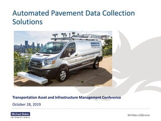
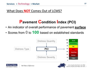
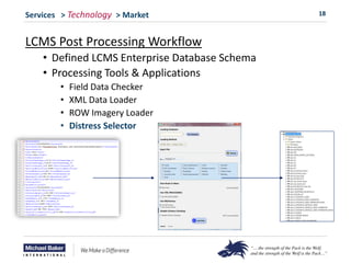
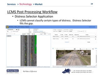
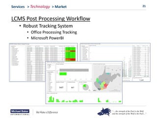
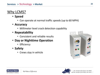
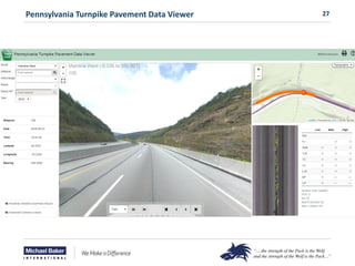
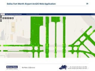
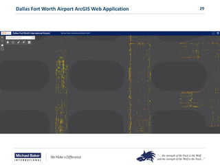
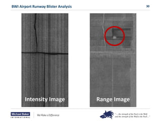
Automated Pavement Data Collection
Solutions
Transportation Asset and Infrastructure Management Conference
October 28, 2019
2
Presentation Overview
Introduction
• Presenter
• What Is Pavement Management?
Services
• Project Level Services
• Network Level Services
Technology
• What Is LCMS?
• What Comes Out of LCMS?
• LCMS Workflows
Market
• Why Pavement Management Is Needed
Project Examples
3
Introduction
Presenter
Ken Contrisciane
• Project Manager GIT – Hamilton, NJ
• 18+ years of service with Michael Baker
• Technical lead in automated pavement data collection
• Broad range of GIS related experience on numerous transportation
asset management/inventory projects at local, county and statewide
levels.
E: kcontrisciane@mbakerintl.com
O: 609-807-9551
4
Introduction
What Is Pavement Management?
“The science of managing limited resources
effectively, by applying the right treatment, on the
right road at the right time”
$1 For Preventive
Maintenance
$5 For Major Repair
5
Services > Technology > Market
Pavement Management Services
• Project Level
• Engineering Design Services
• Ground Penetrating Radar (GPR), Coring, FWD, Skid Testing
• Network Level
• Automated* Pavement Data Collection
• Custom data processing and categorization
• Analysis and Reporting
• Enterprise Pavement Management System Integration
• Program Management
• Project Prioritization
• Training
6
Services > Technology > Market
Pavement Services - Project Level
• Traditional Pavement Data Collection
• Coring
• Pavement depth, type and subgrade
• Falling Weight Deflectormeter (FWD)
• Structural capacity testing
• Ground Penetrating Radar (GPR)
• Identify pavement type, thickness and voids
7
Services > Technology > Market
Pavement Services – Network Level
• Automated* Pavement Data Collection
LCMS - Laser Crack Measurement System
8
Services > Technology > Market
5 High Def ROW Cameras
High Speed Profiler (IRI)
Laser Crack Measurement System
9
Services > Technology > Market
Laser Crack Measurement System
• What is LCMS and how does it work
• What comes out of LCMS
• LCMS Workflows
10
Services > Technology > Market
What is LCMS?
• Mobile-based Automatic* Pavement Distress Detection
• Double Laser Sensor Array
• One Inventory, Many Outputs
• Pavement Management Tool
11
Services > Technology > Market
How LCMS Works
• Sensors Detect Two Primary Attributes:
• Range: Distance between sensor and ground
• Intensity: Laser intensity (greyscale)
Macro-texture
Rut
Crack
Range
(in mm)
11
Intensity
(white = 0,
black = 255)
Right Lane
Marking
12
Services > Technology > Market
How LCMS Works
Crack Severity
RANGE INTENSITY
26.4’
13
Services > Technology > Market
How LCMS Works
Excellent 3D
Accuracy
High
Acquisition
Rate
Good Lateral Resolution
1 Gigabyte of data per mile
14
Services > Technology > Market
What Comes Out of LCMS?
• One Inventory, Many Outputs
• Pavement Condition Features:
• Transverse Profile • Joint Faulting
• Sealed Cracks • Alligator Cracking
• Transverse Cracks • Longitudinal Cracks
• Bleeding • Raveling
• Potholes • Macro Texture
• Rutting • International Roughness Index (IRI)
15
Services > Technology > Market
What Comes Out of LCMS?
• Raw Data: XML and Imagery
16
Services > Technology > Market
What Comes Out of LCMS?
17
Services > Technology > Market
What Does NOT Comes Out of LCMS?
Pavement Condition Index (PCI)
• An indicator of overall performance of pavement surface
• Scores from 0 to 100 based on established standards
Distress Type
Distress Quantity
Distress Severity
PCI
18
Services > Technology > Market
LCMS Post Processing Workflow
• Defined LCMS Enterprise Database Schema
• Processing Tools & Applications
• Field Data Checker
• XML Data Loader
• ROW Imagery Loader
• Distress Selector
19
Services > Technology > Market
LCMS Post Processing Workflow
• Distress Selector Application
• LCMS cannot classify certain types of distress. Distress Selector
fills the gap.
20
Services > Technology > Market
LCMS Post Processing Workflow
• Robust Tracking System
• Field Collection Tracking
• ArcGIS Online, Collector, Survey123 & Microsoft Flow
21
Services > Technology > Market
LCMS Post Processing Workflow
• Robust Tracking System
• Office Processing Tracking
• Microsoft PowerBI
22
Services > Technology > Market
Why LCMS?
• Speed
• Can operate at normal traffic speeds (up to 60 MPH)
• Accuracy
• Millimeter level crack detection capability
• Repeatability
• Consistent and reliable results
• Day or Nighttime Operation
• Efficiency
• Safety
• Crews stay in vehicle
23
Services > Technology > Market
Why Pavement Management Is Need?
Regulations
• Highways & Roads – FAST Act
• National Pavement Performance Measures established in 2018
• State DOT’s required to collect & report certain aspects of
pavement condition
• IRI, Rutting, Cracking Percent, Faulting
• Equipment & Operator Certification
• Potential $$$ penalties if not met
• Airports – AC 150/5380-7B
• Discusses Airport Pavement Management Program (PMP)
• Required for certain projects funded with federal $$$
• Key component of PMP is ability to track & collect pavement
data
24
Services > Technology > Market
Why Pavement Management Is Needed?
Regulations – State Specific
• Case Example: California
• SB 1 – Road Repair & Accountability Act of 2017
• Dedicates $54 billion (state funding) towards transportation
infrastructure improvement and repair.
• Split equally between the state highway system and local
agencies (cities / counties)
25
Project Examples
Project Examples
• West Virginia Department of Highways (WVDOH)
• Pavement Data Viewer
• Pennsylvania Turnpike Commission (PTC)
• PTC Pavement Data Viewer
• Dallas Fort Worth Airport (DFW)
• ArcGIS Web Application
• BWI Airport
• Runway Blister Analysis
26
West Virginia DOH Pavement Data Viewer
27
Pennsylvania Turnpike Pavement Data Viewer
28
Dallas Fort Worth Airport ArcGIS Web Application
29
Dallas Fort Worth Airport ArcGIS Web Application
30
BWI Airport Runway Blister Analysis
Intensity Image Range Image
QUESTIONS?
Thank you!
Ken Contrisciane
GIT Project Manager
Hamilton, NJ
E: kcontrisciane@mbakerintl.com
O: 609-807-9551

automated-pavement-data-collection.pdf

  • 1.
    Automated Pavement DataCollection Solutions Transportation Asset and Infrastructure Management Conference October 28, 2019
  • 2.
    2 Presentation Overview Presentation Overview Introduction •Presenter • What Is Pavement Management? Services • Project Level Services • Network Level Services Technology • What Is LCMS? • What Comes Out of LCMS? • LCMS Workflows Market • Why Pavement Management Is Needed Project Examples
  • 3.
    3 Introduction Presenter Ken Contrisciane • ProjectManager GIT – Hamilton, NJ • 18+ years of service with Michael Baker • Technical lead in automated pavement data collection • Broad range of GIS related experience on numerous transportation asset management/inventory projects at local, county and statewide levels. E: kcontrisciane@mbakerintl.com O: 609-807-9551
  • 4.
    4 Introduction What Is PavementManagement? “The science of managing limited resources effectively, by applying the right treatment, on the right road at the right time” $1 For Preventive Maintenance $5 For Major Repair
  • 5.
    5 Services > Technology> Market Pavement Management Services • Project Level • Engineering Design Services • Ground Penetrating Radar (GPR), Coring, FWD, Skid Testing • Network Level • Automated* Pavement Data Collection • Custom data processing and categorization • Analysis and Reporting • Enterprise Pavement Management System Integration • Program Management • Project Prioritization • Training
  • 6.
    6 Services > Technology> Market Pavement Services - Project Level • Traditional Pavement Data Collection • Coring • Pavement depth, type and subgrade • Falling Weight Deflectormeter (FWD) • Structural capacity testing • Ground Penetrating Radar (GPR) • Identify pavement type, thickness and voids
  • 7.
    7 Services > Technology> Market Pavement Services – Network Level • Automated* Pavement Data Collection LCMS - Laser Crack Measurement System
  • 8.
    8 Services > Technology> Market 5 High Def ROW Cameras High Speed Profiler (IRI) Laser Crack Measurement System
  • 9.
    9 Services > Technology> Market Laser Crack Measurement System • What is LCMS and how does it work • What comes out of LCMS • LCMS Workflows
  • 10.
    10 Services > Technology> Market What is LCMS? • Mobile-based Automatic* Pavement Distress Detection • Double Laser Sensor Array • One Inventory, Many Outputs • Pavement Management Tool
  • 11.
    11 Services > Technology> Market How LCMS Works • Sensors Detect Two Primary Attributes: • Range: Distance between sensor and ground • Intensity: Laser intensity (greyscale) Macro-texture Rut Crack Range (in mm) 11 Intensity (white = 0, black = 255) Right Lane Marking
  • 12.
    12 Services > Technology> Market How LCMS Works Crack Severity RANGE INTENSITY 26.4’
  • 13.
    13 Services > Technology> Market How LCMS Works Excellent 3D Accuracy High Acquisition Rate Good Lateral Resolution 1 Gigabyte of data per mile
  • 14.
    14 Services > Technology> Market What Comes Out of LCMS? • One Inventory, Many Outputs • Pavement Condition Features: • Transverse Profile • Joint Faulting • Sealed Cracks • Alligator Cracking • Transverse Cracks • Longitudinal Cracks • Bleeding • Raveling • Potholes • Macro Texture • Rutting • International Roughness Index (IRI)
  • 15.
    15 Services > Technology> Market What Comes Out of LCMS? • Raw Data: XML and Imagery
  • 16.
    16 Services > Technology> Market What Comes Out of LCMS?
  • 17.
    17 Services > Technology> Market What Does NOT Comes Out of LCMS? Pavement Condition Index (PCI) • An indicator of overall performance of pavement surface • Scores from 0 to 100 based on established standards Distress Type Distress Quantity Distress Severity PCI
  • 18.
    18 Services > Technology> Market LCMS Post Processing Workflow • Defined LCMS Enterprise Database Schema • Processing Tools & Applications • Field Data Checker • XML Data Loader • ROW Imagery Loader • Distress Selector
  • 19.
    19 Services > Technology> Market LCMS Post Processing Workflow • Distress Selector Application • LCMS cannot classify certain types of distress. Distress Selector fills the gap.
  • 20.
    20 Services > Technology> Market LCMS Post Processing Workflow • Robust Tracking System • Field Collection Tracking • ArcGIS Online, Collector, Survey123 & Microsoft Flow
  • 21.
    21 Services > Technology> Market LCMS Post Processing Workflow • Robust Tracking System • Office Processing Tracking • Microsoft PowerBI
  • 22.
    22 Services > Technology> Market Why LCMS? • Speed • Can operate at normal traffic speeds (up to 60 MPH) • Accuracy • Millimeter level crack detection capability • Repeatability • Consistent and reliable results • Day or Nighttime Operation • Efficiency • Safety • Crews stay in vehicle
  • 23.
    23 Services > Technology> Market Why Pavement Management Is Need? Regulations • Highways & Roads – FAST Act • National Pavement Performance Measures established in 2018 • State DOT’s required to collect & report certain aspects of pavement condition • IRI, Rutting, Cracking Percent, Faulting • Equipment & Operator Certification • Potential $$$ penalties if not met • Airports – AC 150/5380-7B • Discusses Airport Pavement Management Program (PMP) • Required for certain projects funded with federal $$$ • Key component of PMP is ability to track & collect pavement data
  • 24.
    24 Services > Technology> Market Why Pavement Management Is Needed? Regulations – State Specific • Case Example: California • SB 1 – Road Repair & Accountability Act of 2017 • Dedicates $54 billion (state funding) towards transportation infrastructure improvement and repair. • Split equally between the state highway system and local agencies (cities / counties)
  • 25.
    25 Project Examples Project Examples •West Virginia Department of Highways (WVDOH) • Pavement Data Viewer • Pennsylvania Turnpike Commission (PTC) • PTC Pavement Data Viewer • Dallas Fort Worth Airport (DFW) • ArcGIS Web Application • BWI Airport • Runway Blister Analysis
  • 26.
    26 West Virginia DOHPavement Data Viewer
  • 27.
  • 28.
    28 Dallas Fort WorthAirport ArcGIS Web Application
  • 29.
    29 Dallas Fort WorthAirport ArcGIS Web Application
  • 30.
    30 BWI Airport RunwayBlister Analysis Intensity Image Range Image
  • 31.
  • 32.
    Ken Contrisciane GIT ProjectManager Hamilton, NJ E: kcontrisciane@mbakerintl.com O: 609-807-9551