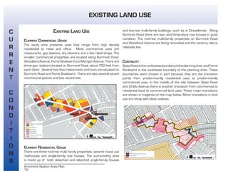
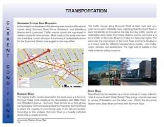
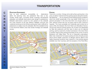
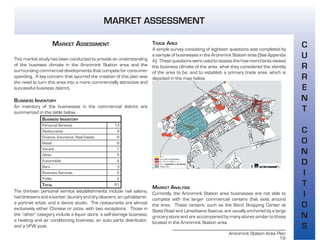
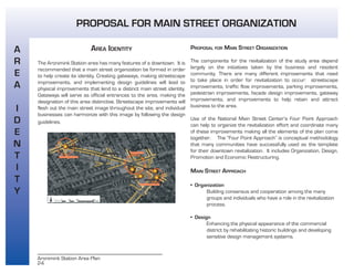
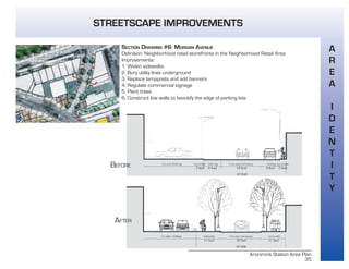
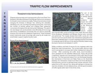
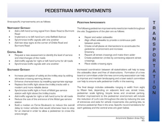
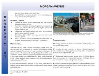
SlideShare a Scribd company logo
cover page
Aronimink Station Area Plan
TABLE OF CONTENTS
1
ACKNOWLEDGEMENTS 4
EXECUTIVE SUMMARY 4
INTRODUCTION
PLANNING PURPOSE 5
PLANNING PROCESS 5
STUDY AREA DESCRIPTION 5
HISTORICAL CONTEXT 6
CURRENT CONDITIONS
DEMOGRAPHICS 7
DEVELOPMENT PATTERNS 10
LANDMARKS 11
EXISTING LAND USE 12
EXISTING ZONING 13
TRANSPORTATION 15
MARKET ASSESSMENT 19
ISSUES AND OPPORTUNITIES 20
THE PLAN 22
VISION STATEMENT 22
GOALS 22
AREA IDENTITY 24
PROPOSAL FOR MAIN STREET ORGANIZATION 24
GATEWAYS 26
STREETSCAPE IMPROVEMENTS 28
DESIGN GUIDELINES 40
TRANSPORTATION IMPROVEMENTS 44
TRAFFIC FLOW IMPROVEMENTS 44
PEDESTRIAN IMPROVEMENTS 45
PARKING IMPROVEMENTS 47
MORGAN AVENUE 48
COMMERCIAL REVITALIZATION 49
WAVERLY THEATER 49
POST OFFICE 52
ARONIMINK STATION 53
VACANT LOTS 55
EXISTING AND PROPOSED DEVELOPMENT 57
IMPLEMENTATION
NEXT STEPS 58
FUNDING 59
FOR OVERALL AREA REVITALIZATION 59
FOR HISTORIC PRESERVATION 59
TIMELINE FOR GOALS AND OBJECTIVES 60
REFERENCES 62
APPENDICES
APPENDIX A: MERCHANT SURVEY 65
APPENDIX B: DOWNTOWN ACTION PLAN 69
APPENDIX C: AMBLER CASE STUDY 70
APPENDIX D: ADDITIONAL TRANSPORTATION INFORMATION 71
APPENDIX E: DETAILS ON FUNDING SOURCES 75
APPENDIX F: IMPORTANT CONTACT INFORMATION 77
4
Aronimink Station Area Plan
ACKNOWLEDGEMENTS
We would like to thank the following individuals for their time,
comments and input.
Our Clients : Jim Glatts, Joann Cook, Helen Horn and Donna Vesci
Our Instructors: Gabriela Cesarino, Paul Rookwood, and Nancy Zobl
from the firm Wallace, Roberts and Todd, LLC
The University of Pennsylvania School of Design Faculty and Staff
The Local Business Owners of the Aronimink Station Area
Bernadette Dougherty, Ambler Main Street Manager
Tom Smith, Sellers Library Archivist
Thomas DiFilippo, Author of The History and Development of Upper
Darby Township
Andrew Dobshinsky for his software expertise
EXECUTIVE SUMMARY
The vision of the Aronimink Station Area Plan is to create a vibrant
main street for Drexel Hill where pedestrians, transit-users, and
drivers alike will enjoy shopping, dining and entertainment.
Formulated by five University of Pennsylvania Master of City
Planning students in the spring of 2004, this vision was created
to address revitalization needs identified by four area residents
and business owners. The report includes analysis that led to this
vision and implementation strategies that will help to achieve this
vision. It begins with an overview of the site including site history
and current conditions. Then the key issues and opportunities for
the area are identified, followed by the vision statement, goals, and
plan for action.
The goals for the Aronimink Station Area Plan are to create a
distinct identity for the area, to make transportation improvements,
and to revitalize the commercial district. According to the
recommendations of this plan, retail space will be increased by
7000 feet, twenty-four new residential units will be added, and
seventy-four new parking spaces will be added. A future site plan
details all the suggested improvements.
The objectives for creating a distinct identity for the Aronimink
Station area include forming a Main Street Organization, creating
gatewaysatthesiteboundaries,makingstreetscapeimprovements,
and implementing design guidelines. The objectives for improving
the transportation through this area include traffic flow, pedestrian,
and parking improvements. The objectives for revitalizing the
commercial district include restoring key landmarks and infilling
vacant lots.
The report concludes with implementation strategies, including a
summary of next steps, funding sources, and a timeline. With the
active involvement of area residents, business owners, and other
stakeholders, the Aronimink Station Area Plan can be used as a
tool to guide the revitalization process.
ACKNOWLEDGEMENTS AND EXECUTIVE SUMMARY
Aronimink Station Area Plan
5
PLANNING PURPOSE
The Aronimink Station area has experienced a decline in recent
years as it struggles to balance automotive and pedestrian
needs. The purpose of this plan is to identify the key issues and
opportunitiesfortheAroniminkStationarea,andtogivesuggestions
to area residents and business owners on how this area could be
revitalized.
PLANNING PROCESS
In the spring of 2004, a project team consisting of five first-year
graduate students in the Department of City and Regional Planning
at the University of Pennsylvania were given the assignment to
develop a plan for the Aronimink Station area. The students were
guided by professionals who supervised the planning process. Area
business and resident representatives were designated as clients
for this project. These clients gave important feedback that helped
the students understand the planning problem and what changes
were desired.
Data were compiled from a variety of sources such as the U.S.
Census and the Upper Darby zoning codes. A merchant survey
of area businesses was conducted to help analyze the current
market conditions. The students selected relevant case studies
and met with leaders from the local and surrounding communities.
Additionally, they developed a physical assessment of the site by
taking measurements and photographs, observing traffic and
parking conditions, and noting the design features of the area. Upon
analyzing these data, the students have made recommendations
which are given in detail in this report.
STUDY AREA DESCRIPTION
This plan focuses on the area surrounding the Aronimink Station
in Upper Darby Township, an inner-ring suburb in Delaware County
just west of Philadelphia,Pennsylvania. The Aronimink Station is a
stop on the Southeastern Pennsylvania Transportation Authority’s
(SEPTA) trolley route 101. The focus area, a commercial district on
Burmont Road between Ferne Boulevard and State Road, is part of
the Drexel Hill neighborhood of Upper Darby Township.
Above: Map of Upper Darby
Township, Aronimink Station area
highlighted in red. Right: Map
of Aronimink Station area, site
boundary highlighted in read.
INTRODUCTION
6
Aronimink Station Area Plan
HISTORICAL CONTEXT
DEVELOPMENT OF UPPER DARBY TOWNSHIP
Upper Darby was first settled in 1688 and was incorporated as a
Township in 1736. In 1907, the Philadelphia Rapid Transit line was
extended throughout the area. In 1916, John McClatchy purchased
thirty acres of cow pasture in order to develop the area surrounding
the 69th Street Terminal.
69TH STREET TERMINAL AREA
McClatchy began his plans for developing a shopping district around
the 69th Street Terminal in 1920. Construction of this district
began in 1928. The McClatchy Building and Tower Theater were
completed that same year. The 69th Street Terminal shopping and
cultural district was a novel idea developed well before suburban
shopping malls came into vogue. According to the book on Upper
Darby’s development by Thomas DiFilippo, “by 1930 the shopping
center ranked second only to Center City Philadelphia in retail sales”
(96).
DEVELOPMENT OF FERNE BOULEVARD
Another developer, Thomas Sheridan, made plans to create a
shopping district to compete with the 69th street shopping district
on Ferne Boulevard in the late 1920s. Sheridan had originally
planned to build Ferne Boulevard as a wide boulevard with a cluster
of stores to attract customers riding the nearby trolley. This area
was called Aronimink Golf Estates and was completed in October
1927. It included the Waverly Theater and the ninety-foot boulevard.
At this time, ten stores and twenty-one efficiency apartments were
being constructed along the boulevard. Ferne Boulevard was
originally planned to be a grand development, but plans were scaled
down during the Great Depression (DiFilippo 104).
The Waverly Theater was built by Stanley Corporation of America. It
was originally supposed to be called “The Drexel” but the name was
later changed to Waverly.
ARONIMINK STATION AREA PLAN
The transit-oriented developments by McClatchy and Sheridan
did not take into consideration the increasing popularity of the
automobile and have suffered congestion and deterioration as a
result.
In order to revitalize the area, the Aronimink Station Area Plan seeks
to merge Sheridan’s original intentions with the transportation and
land use constraints of today.
INTRODUCTION
Aronimink Station Area Plan
7
DEMOGRAPHICS
In examining the existing conditions of this area, it is important
to understand some key population characteristics. In this
plan five pieces of demographic data were examined, including
population growth, racial and ethnic population, median income
and employment. U.S. Census data for the study area, defined
by the block groups highlighted in yellow on the map below, were
compared to that of the Upper Darby Township, the surrounding
Boroughs of Aldan, Clifton Heights, Lansdowne, and Yeadon, the
Townships of Haverford and Springfield, and Bucks, Chester,
Delaware, Philadelphia, and Montgomery Counties.
POPULATION CHANGE
The Upper Darby Township as a whole was the only community out
of the surrounding townships and boroughs to gain in population
over the last ten years. Additionally, the study area’s gain in
population kept pace with the Township. However, at less than
one percent, this gain is statistically unimportant and indicates
the population of both the study area and the Township is stable.
According to the 2000 U.S. Census, the population of Upper Darby
was about 82,000, and for the block group area it was 10,000.
The population change in the immediate study area is indicative of a
more fundamental population shift, with more familes with younger
children moving into the area.
Source: U.S. Census Bureau
DEMOGRAPHICS
C
U
R
R
E
N
T
C
O
N
D
I
T
I
O
N
S
8
Aronimink Station Area Plan
RACE AND ETHNICITY
The racial and ethnic composition of the study area is relatively
stable, with little change between 1990 and 2000. During this
time, the white population as a percent of the total, declined from
95% to 87%. The African-American population increased by 1.3%
and the Asian and Pacific Islander population increased by 4.8%,
while the hispanic population rose minimally. This 1.3% increase in
the African-American population, however, represented a doubling
of the population in absolute numbers, much as the 4.8% increase
in the Asian population represented a rise of 150% over the 1990
numbers.
Source: U.S. Census Bureau
MEDIAN INCOME
The median income in the immediate study area, while still lower
than that of the adjacent townships, it is significantly higher than
the median income in the adjacent boroughs and the Upper Darby
Township as a whole. This is significant for it indicates the population
in the Aronimink Station area has a relatively high amount of money
available for non-essential spending.
Source: U.S. Census Bureau
C
U
R
R
E
N
T
C
O
N
D
I
T
I
O
N
S
DEMOGRAPHICS
Aronimink Station Area Plan
9
EMPLOYMENT
This chart reflets the increase in the number of jobs between 1998
and 2001. Because of the way this information is tabulated, the
19026 zip code was used to approximate the boundaries of the
study area. This data shows a an 8% increase in the number of
jobs in the immediate area, a rate of increase which topped all the
other areas.
Source: U.S. Census Bureau
DEMOGRAPHICS
C
U
R
R
E
N
T
C
O
N
D
I
T
I
O
N
S
10
Aronimink Station Area Plan
DEVELOPMENT PATTERNS
URBAN PATTERN
The urban pattern of the Upper Darby Township is defined by a grid
that runs north-south and east-west. There are four commercial
districts in the Township that compete with our site, all highlighted
in the map above. Burmont Road is used as a throughway which
diagonally crosses the grid pattern of residential zone. Burmont
Road is one of the few roads that grants access across the trolley
railway tracks connecting the north and south of the Township,
This makes it a heavily trafficked road with several congested
intersections.
FIGURE GROUND PATTERN
This figure ground study illustrates and distinguishes the uniform
residential pattern, that is interrupted by the commercial corridor.
It is visible that the pattern along the three major intersections is
not continuous. This also shows the density of development in the
area as it exists today.
DEVELOPMENT PATTERNS
C
U
R
R
E
N
T
C
O
N
D
I
T
I
O
N
S
Aronimink Station Area Plan
11
LANDMARKS
THE WAVERLY THEATER
The Waverly Theater was built in 1927 by Thomas Sheridan.
Currently, two-thirds of the Waverly Theater building is being used
by Waverly Self-Storage. The other one-third is divided between
Mescellino’s Pizzeria and J.D. McGillicuddy’s Restaurant & Pub.
Since the theater closed in the 1980s, several other businesses
previously used the building, The current uses do not utilize the full
potential of this important historical landmark.
THE POST OFFICE
The Post Office at Burmont
Road and Woodland
Avenue was built in 1927.
The building is still used as a
Post Office today, although
the United States Postal
Service has considered
moving their operations
to another location and
reducing their presence to
a small storefront office. The Post Office owns and uses the two
adjacent parking lots for private purposes only.
ARONIMINK STATION
The Aronimink Station area grew initially as a transit-oriented
development around the Philadelphia Rapid Transit line, built in
1907, The trolley provided service between Upper Darby Township
and Center City, Philadelphia, the primary employment center for
the region. Today it is served by SEPTA trolley route 101. The
station building and its surroundings are in poor physical condition.
LANDMARKS
C
U
R
R
E
N
T
C
O
N
D
I
T
I
O
N
S
12
Aronimink Station Area Plan
EXISTING LAND USE
CURRENT COMMERCIAL USAGE
The study area presents uses that range from high density
residential to retail and office. Most commercial uses are
restaurants, gas stations, dry cleaners and a few retail shops. The
smaller commercial properties are located along Burmont Road,
Woodland Avenue, Ferne Boulevard and Morgan Avenue. There are
three gas stations located on Burmont Road, about 700 feet from
each other. Several fast food restaurants and bars are situated on
Burmont Road and Ferne Boulevard. There are also several vacant
commercial spaces and two vacant lots.
CURRENT RESIDENTIAL USAGE
There are three mid-rise multi family properties, several mixed use
rowhouses and single-family row houses. The surrounding area
is made up of both detached and attached single-family houses
and low-rise multi-family buildings, such as in Drexelbrook. Along
Burmont Road there are two- and three-story row houses in good
condition. The mid-rise multi-family properties on Burmont Road
and Woodland Avenue are being renovated and the vacancy rate is
relatively low.
CONTINUITY
StateRoadisthenorthwestboundaryoftheplanningarea,andFerne
Boulevard is the southeast boundary of the planning area. These
boundaries were chosen in part because they are the transition
points from predominantly residential uses to predominantly
commercial uses. In the middle of the site between State Road
and Childs Avenue there is another transition from commercial to
residential back to commercial land uses. These major transitions
are shown in magenta on the map below. Minor transitions in land
use are show with black outlines.
C
U
R
R
E
N
T
C
O
N
D
I
T
I
O
N
S
EXISTING LAND USE
Aronimink Station Area Plan
13
EXISTING ZONING
The current zoning pattern surrounding the Aronimink Station area
is very diverse. There are three distinct residential districts, R-1, R-2
and R-3. The R-1 district permits only single-family detached homes
with special exceptions for schools, churches, hospitals, cemeteries
and outdoor swimming and tennis clubs. R-2 includes all the R-1
permits, but also allows a minimum lot area of 5,000 square feet
and a minimum street frontage of twenty feet less than R-1. R-3
includes the uses allowed in R-1 and R-2 districts, and additionally
includes two-family detached homes, apartment buildings thirty-five
feet or less in height, retirement homes, and mobile home parks.
The Aronimink Station area is zoned Neighborhood Commercial,
designated C-1. The primary uses permitted in a C-1 district
include food stores, drug stores, bakeries, dry cleaners, banks and
accountant or insurance broker offices. The C-1 zoning district was
intended to create a commercial and service-oriented business
corridor to meet the needs of individuals living in the immediate
neighborhood of the Aronimink Station area.
C
U
R
R
E
N
T
C
O
N
D
I
T
I
O
N
S
EXISTING ZONING
14
Aronimink Station Area Plan
INCONSISTENCIES
There are several current land uses inconsistent with the zoning
designations for the Aronimink Station area. For example the C-1
designation, according to the Upper Darby zoning code regulations,
does not allow the drive-in windows currently in use at the two study
area banks. There are three gas stations within the area that are
not currently allowed by the C-1 zoning. C-2 zoning allows gas
stations but section 502-n limits them to perform only minor repairs
related to state inspections. C-1 section 501-A2a also specifically
states that no residential use is permitted in conjunction with the
commercial uses. There are also several mixed-use row houses,
with commercial on the first floor and residential on the floors
above. Inconsisten A new comprehensive plan for the Township has
recently been completed and recommended zoning code changes
will address some of these inconsistencies.
EXISTING LAND USE
C
U
R
R
E
N
T
C
O
N
D
I
T
I
O
N
S
Aronimink Station Area Plan
15
TRANSPORTATION
PUBLIC TRANSPORTATION
SEPTA trolley route 101, which runs from the 69th Street Terminal
to Media, stops at the Aronimink Station. There is also a bus route
along State Road that can be used for access to the planning area.
Mass transit ridership in the area is low -- according to data from the
U.S. Census, under four percent of people use public transportation.
Most people choose to drive -- personal vehicle usage is the highest
mode of transportation in the area, representing 88% of all trips.
There are no parking facilities to accomodate park-and-ride transit
users at the Aronimink Station.
The trolley service is frequent and generally on time. During the
morning rush hour, the trolley comes approximately every four to
nine minutes between 6:54 and 8:00 AM. During the evening rush
hour, the trolley comes every nine to fifteen minutes between 4:30
and 6:30 PM. Late evening and weekend service is less frequent,
and the last stop at Aronimink Station is at 9:50 PM. To get from
Aronimink Station to Center City Philadelphia, it takes an average of
thirty-eight minutes.
UPPER DARBY ROADWAYS
As shown on the map above, roadways in Upper Darby fit into
three categories: arterial roads, collector roads, and local roads.
Local roads are the small streets and roads that provide access
to neighborhoods and commercial areas. Collector roads “collect”
the traffic from the smaller local roads and funnels it onto arterial
roadways. Arterial roads are high-capacity thoroughfares that move
vehicles across the Township and into the wider region.
TRANSPORTATION
C
U
R
R
E
N
T
C
O
N
D
I
T
I
O
N
S
16
Aronimink Station Area Plan
ARONIMINK STATION AREA ROADWAYS
In the analysis of roadways in the planning area, hourly traffic volume
counts along Burmont Road, Ferne Boulevard, and Woodland
Avenue were conducted. Traffic volume counts are expressed in
relation to specific time periods. Most roads in the study area have
one travel lane in each direction. A summary of road classifications
for the Aronimink Station area is given in the map below.
BURMONT ROAD
The highest traffic counts observed in the study area are found on
Burmont Road, most notably at its intersections with State Road
and Woodland Avenue. Burmont Road serves as a throughway
connectingthenorthandsouthendsoftheTownship.BurmontRoad
is where the majority of commercial uses in the site are located.
According to this analysis, Burmont Road is a heavily trafficked
street that is unsafe at times.
The traffic counts along Burmont Road at both rush and non-
rush hours were relatively close, signifying that Burmont Road is
used constantly at throughout the day. Evening traffic counts on
weeknights were lower than these daytime counts, but there is a
lot of traffic on Burmont Road on Friday and Saturday nights. The
area near the intersection of Burmont Road and Ferne Boulevard
is a major node for different transportation modes -- the trolley,
motor vehicles, and pedestrians. The high level of activity in this
node presents safety concerns.
STATE ROAD
State Road can be classified as a minor arterial or major collector
road. It connects with West Chester Pike, a large arterial road used
to access Philadelphia and the Main Line. Within the Aronimink
Station area, State Road connects with Burmont Road.
TRANSPORTATION
C
U
R
R
E
N
T
C
O
N
D
I
T
I
O
N
S
Aronimink Station Area Plan
17
TRANSPORTATION
FERNE BOULEVARD
The eighty-eight feet wide Ferne Boulevard has one travel lane in
each direction and angled-parking on both sides between Burmont
Road and Valley Road.
WOODLAND AVENUE
Woodland Avenue is a collector road that runs parallel to the trolley
line.
MORGAN AVENUE
Morgan Avenue is a one-way road going east to west away from
Burmont Road.
C
U
R
R
E
N
T
C
O
N
D
I
T
I
O
N
S
18
Aronimink Station Area Plan
PEDESTRIAN ENVIRONMENT
Due to poor pedestrian accessibility to destinations
within the planning area, the pedestrian flow rate is low.
Unclear street signs, unmarked street crossings, ill-maintained
sidewalks, and sidewalk obstructions pose danger to pedestrians.
Sidewalk obstructions caused by cars parked on the sidewalk
are most frequent at the gas stations. Multiple curb-cuts and
undefined entrances to the surface parking lots make it difficult for
pedestrians to safely cross the sidewalks. All of the establishments
in the Aronimink Station area have street frontage and sidewalk
access.
PARKING
There are a number of large and small surface parking lots in the
area, as well as metered and free parking spaces along the streets.
See Appendix ___ for an inventory of the existing parking conditions,
which are shown graphically in the map below. While there is a
general perception in the area that there are enough places to
park, several surface lots are not being used to their maximum
capacity. The most accessible and frequently used surface lot is
next to Rite Aid between Burmont Road and Woodland Avenue.
This lot has forty-one parking spaces, ten of which are designated
for Rite Aid customers and the rest of which are for general
parking, used by customers of other businesses in the area. There
is another large surface parking lot located at the corner of Ferne
Boulevard and Valley Road. This lot is frequently underutilized.
Other lots include the four-space parking lot that primarily serves
Heron Home Health customers on Morgan Avenue. Most of the
highly frequented locations have metered or free parking spaces
available near their business, with the exception of the Post Office.
C
U
R
R
E
N
T
C
O
N
D
I
T
I
O
N
S
TRANSPORTATION
Aronimink Station Area Plan
19
C
U
R
R
E
N
T
C
O
N
D
I
T
I
O
N
S
MARKET ASSESSMENT
MARKET ASSESSMENT
This market study has been conducted to provide an understanding
of the business climate in the Aronimink Station area and the
surrounding commercial developments that compete for consumer
spending. A key concern that spurred the creation of this plan was
the need to turn this area into a more commercially attractive and
successful business district.
BUSINESS INVENTORY
An inventory of the businesses in the commercial district are
summarized in the table below.
BUSINESS INVENTORY
Personal Services 13
Restaurants 9
Finance, Insurance, Real Estate 8
Retail 8
Vacant 7
Other 5
Automobile 4
Bars 3
Business Services 2
Public 2
TOTAL 61
The thirteen personal service establishments include nail salons,
hairdressers and a barber, laundry and dry cleaners, an upholsterer,
a portrait artist, and a dance studio. The restaurants are almost
exclusively either Chinese or pizza, with two exceptions. Those in
the “other” category include a liquor store, a self-storage business,
a heating and air conditioning business, an auto parts distributor,
and a VFW post.
TRADE AREA
A simple survey consisting of eighteen questions was completed by
a sample of businesses in the Aronimink Station area (See Appendix
A). These questions were used to assess the how merchants viewed
the business climate of the area, what they considered the identity
of the area to be, and to establish a primary trade area, which is
depicted in the map below.
MARKET ANALYSIS
Currently, the Aronimink Station area businesses are not able to
compete with the larger commercial centers that exist around
the area. These centers, such as the Bond Shopping Center at
State Road and Lansdowne Avenue, are usually anchored by a large
grocery store and are accompanied by many stores similar to those
located in the Aronimink Station area.
20
Aronimink Station Area Plan
ISSUES AND OPPORTUNITIES
Client interviews and the current conditions analysis were used to
identify the key issues and opportunities for the Aronimink Station
area. The map on the right visually summarizes these issues and
opportunities.
The issues of the Aronimink Station area are:
• Lack of a distinct identity
• Poor visual appearance
• Traffic congestion
• Unfriendly pedestrian environment
• Perceived lack of parking
• Decline in commercial activity
These issues can be turned into opportunities, and the remaining
sections of this report discuss how these opportunities can be
realized. As shown on the map, streetscape improvements are
recommended throughout the area. The central point of the site is
the intersection of Burmont Road, Drexel Avenue, and Woodland
Avenue. This point is the current as well as future center of activity
for the Aronimink Station area. Creating gateways at the northwest
and southeast boundaries of the site will help with the area’s image
development. Improvements to traffic flow and the pedestrian
environment are suggested. Rearrangement suggestions for the
parking lots are given. Upgrading area landmarks and infilling vacant
lots is recommended for increasing commercial activity. The issues
and opportunities summarized in the map are not comprehensive.
They provide an overview of the kinds of improvements that are
recommended in this plan.
Aronimink Station Area Plan
21
ISSUES AND OPPORTUNITIES
22
Aronimink Station Area Plan
THE PLAN
THE PLAN
The Aronimink Station area has many of the features of a downtown:
neighborhood commercial retail, restaurants, and historic buildings.
The underlying character of the site is that of a downtown, and
developing the area as a downtown is the most appropriate and
most feasible plan for revitalizing the area.
VISION STATEMENT
The vision of the Aronimink Station Area Plan is to create a vibrant
main street for Drexel Hill where pedestrians, transit-users, and
drivers alike will enjoy shopping, dining, and entertainment.
GOALS
The following three goals will help to achieve this vision:
• Create a downtown identity for the Aronimink Station area
• Make transportation improvements
• Revitalize the commercial district
Aronimink Station Area Plan
23
THE PLAN
S
I
T
E
P
L
A
N
24
Aronimink Station Area Plan
AREA IDENTITY
The Aronimink Station area has many features of a downtown. It is
recommended that a main street organization be formed in order
to help create its identity. Creating gateways, making streetscape
improvements, and implementing design guidelines will lead to
physical improvements that lend to a distinct main street identity.
Gateways will serve as official entrances to the area, making the
designation of this area distinctive. Streetscape improvements will
flesh out the main street image throughout the site, and individual
businesses can harmonize with this image by following the design
guidelines.
PROPOSAL FOR MAIN STREET ORGANIZATION
The components for the revitalization of the study area depend
largely on the initiatives taken by the business and resident
community. There are many different improvements that need
to take place in order for revitalization to occur: streetscape
improvements, traffic flow improvements, parking improvements,
pedestrian improvements, façade design improvements, gateway
improvements, and improvements to help retain and attract
business to the area.
Use of the National Main Street Center’s Four Point Approach
can help to organize the revitalization effort and coordinate many
of these improvements making all the elements of the plan come
together. The “Four Point Approach” is conceptual methodology
that many communities have successfully used as the template
for their downtown revitalization. It includes Organization, Design,
Promotion and Economic Restructuring.
MAIN STREET APPROACH
• Organization
Building consensus and cooperation among the many
groups and individuals who have a role in the revitalization
process.
• Design
Enhancing the physical appearance of the commercial
district by rehabilitating historic buildings and developing
sensitive design management systems.
A
R
E
A
I
D
E
N
T
I
T
Y
PROPOSAL FOR MAIN STREET ORGANIZATION
Aronimink Station Area Plan
25
• Promotion
Marketing the traditional commercial district’s assets to
customers, potential investors, new businesses, local
citizens and visitors.
• Economic Restructuring
Strengthening the district’s existing economic base while
finding ways to expand it to meet new opportunities.
There is a highly detailed and structured series of training sessions,
workbooks, videos and slide shows for the Main Street Approach
which show members of the community how to do downtown
revitalization for themselves and sustain the effort into the future.
The Pennsylvania Downtown Center is an independent statewide
non-profit organization which provides this training and other
technical assistance and can help the Aronimink Station area
community get going with the revitalization process.
“PDC is obligated by its agreement with the Commonwealth to
provide certain outreach and preliminary assessment services to
any community contemplating a downtown revitalization program.
Beyond these initial introductory and community assessment
services, PDC must charge a fee for services such as visioning,
planning, market area assessment, etc. Members of PDC receive a
significant discount for these services. If a community is fortunate
enough to be accepted into the Commonwealth’s Main Street
Program, the services provided by PDC to the Main Street program
participant are free for the duration of the time the community is in
the program - normally for five years” (padowntown.org FAQ).
A
R
E
A
I
D
E
N
T
I
T
Y
PROPOSAL FOR MAIN STREET ORGANIZATION
26
Aronimink Station Area Plan
GATEWAYS
The intersections on Burmont Road at State Road and at Ferne
Boulevard have been designated as the gateways for the Aronimink
Station area. These gateways will serve as clear entry points for the
area and will help develop the image of the Aronimink Station area
as a downtown. Welcome signs and flower beds should be included
at both gateways.
Currently, the intersection of Burmont and State is not pedestrian
friendly. This intersection is confusing for motorists as well as
pedestrians with several traffic lights and potential areas for
pedestrians to cross the street. Street signs at this intersection
are too small or nonexistent, the existing pedestrian crosswalks
are faded and need to be repainted, and additional crosswalks
need to be created. There is a strip of neighborhood commercial
development on the western end of the intersection on State Road.
This commercial strip is not easily accessible to pedestrians. Also,
there is a billboard above this commercial strip. The Berrodin
Building is the most prominent feature of this intersection. It has a
blank wall facing State Road that is not very aesthetically pleasing
and there is very little landscaping in this area.
This rendering shows the changes to be made at the Burmont and
State gateway, also illustrated in the picture below.
This picture shows how this intersection can be beautified. Trees,
flowers, a welcome sign, a mural, larger street signs, banners, and
crosswalks have been added.
A
R
E
A
I
D
E
N
T
I
T
Y
GATEWAYS
Aronimink Station Area Plan
27
The most noticeable features of the intersection of Burmont Road
and Ferne Boulevard are the Mobil Gas Station and the Waverly
Theater.
The drawing above illustrates the changes to be made at the
intersection of Burmont and Ferne. Landscaping improvements
include the addition of a flower bed at the corner near the gas
station and the addition of the median along Ferne Boulevard.
There are many historic buildings in this area, and the façades
of these buildings need to be restored. Signage should be in
compliance with the design guidelines. It should not detract from
the architecture or the overall streetscape.
This picture shows how this intersection can be improved. The size
of the signage for the Mobil Gas Station is reduced and the sign
above the Waverly Bar has been removed. Electrical wires have
been moved underground. Landscaping has been added around
the gas station, and a welcome sign has been placed at the corner.
Crosswalks have been added.
A
R
E
A
I
D
E
N
T
I
T
Y
GATEWAYS
28
Aronimink Station Area Plan
STREETSCAPE IMPROVEMENTS
This section of the report illustrates ideas for streetscape improve-
ments in detail. The goals of these streetscape improvements are
to beautify and visually unify the Aronimink Station area. The fol-
lowing are descriptions of individual streetscape improvement ele-
ments:
BANNERS AND LAMPPOSTS
Many downtown and cultural districts throughout the country use
banners on their lampposts to promote area identity, events, holi-
days, and community spirit. Using these banners all along Burmont
Road and adjacent streets within the site boundaries will visually
unify the area as well as help designate it as a downtown.
The picture on the left above is an example of a banner design that
could be used for the Aronimink Station area. The use of green and
white in the banner is a reference to the colors of the Waverly The-
ater. The design used for the banner should reflect the character
of the neighborhood. The example on the right above was found
on the internet. This banner is interesting because it identifies the
area (Downtown Wooster) as well as highlights an important event
going on in the area (Woosterfest). Many communities change ban-
ners with the seasons or to highlight different events. Downtown
banners can serve as an appealing and relatively subtle form of
advertisement. In the Downtown Wooster banner picture, note the
attractive lamppost as well as the banner itself. Currently, the lamp-
posts used in the Aronimink Station area are standard street lights.
Replacing these lampposts with more decorative ones is another
way to improve the streetscape and make the area look more like
a downtown.
SIGNAGE
Currently, the signage for many businesses is often worn or inad-
equate, whereas conspicuous and less aesthetically-appealing sig-
nage, such as billboards, is prominent. Street signs are often too
small. In general, signage improvements need to be made through-
out the area so that signs are informative, tasteful, and in keeping
with the vision of this plan.
LANDSCAPING
Greening this area will make it more pleasant for its users as well
as for those just passing through. Planting trees and flowers in sev-
eral designated areas is recommended.
STREET FURNITURE
Street furniture includes benches, lampposts and trash cans. If this
is to be an area where people gather and spend time, the addition
of street furniture is a desirable amenity. In particular, it is recom-
mended that street furniture such as café tables be added on the
side of Ferne Boulevard next to the Waverly Theater, because this
is expected to be a major gathering point.
A
R
E
A
I
D
E
N
T
I
T
Y
STREETSCAPE IMPROVEMENTS
Aronimink Station Area Plan
29
CONTINUITY
To create a coherent and distinct identity for the area, gaps and
edges need to be transformed. In some cases, this means widening
the sidewalks so that sidewalk widths are consistent along a given
corridor. Another recommendation made is to add short walls at
the edges of parking lots and other areas with large amounts of
pavement such as gas stations. These walls will not only improve
the visual continuity of the site, they will improve traffic flow and
make the environment more pedestrian friendly.
UNDERGROUND ELECTRIC WIRES
Currently, an abundance of electrical wires mar the landscape of
the Aronimink Station area. Many of these wires can go under-
ground. This is a long-term project, but many municipalities have
undertaken this process as a part of other big infrastructure im-
provements.
SECTIONS
The following pages show section drawings of the current and
future streetscape, and the portion of the site plan each section
drawing refers to. There are ten sections, each of which is slightly
different.
A
R
E
A
I
D
E
N
T
I
T
Y
STREETSCAPE IMPROVEMENTS
30
Aronimink Station Area Plan
STREETSCAPE IMPROVEMENTS
A
R
E
A
I
D
E
N
T
I
T
Y
SECTION DRAWING #1: BURMONT ROAD
Definition: Neighborhood retail storefronts in the Neighborhood Retail Area
Improvementss:
1. Bury utility lines underground
2. Replace lampposts and add banners
3. Regulate commercial signage
4. Plant trees
5. Construct low walls to beautify the edge of parking lots
BEFORE
AFTER
BROTHERS AREA
Aronimink Station Area Plan
31
SECTION DRAWING #2: BURMONT ROAD
Definition: Neighborhood retail storefronts in the Neighborhood Retail Area
Improvements:
1. Bury utility lines underground
2. Replace lampposts and add banners
3. Regulate commercial signage
4. Plant trees
BEFORE
AFTER
STREETSCAPE IMPROVEMENTS
A
R
E
A
I
D
E
N
T
I
T
Y
RITE AID AREA
32
Aronimink Station Area Plan
STREETSCAPE IMPROVEMENTS
A
R
E
A
I
D
E
N
T
I
T
Y
SECTION DRAWING #3: BURMONT ROAD
Definition: Commercial land uses in the Neighborhood Retail Area
Improvements:
1. Widen sidewalks
2. Bury utility lines underground
3. Add banners
4. Plant trees
5. Install flower beds to divide public and private realms
BEFORE
AFTER
AREA NEAR 740 BURMONT ROAD
Aronimink Station Area Plan
33
STREETSCAPE IMPROVEMENTS
A
R
E
A
I
D
E
N
T
I
T
Y
SECTION DRAWING #4: BURMONT ROAD
Definition: Commercial land uses in the Office Area
Improvements:
1. Widen sidewalks
2. Bury utility lines underground
3. Add banners
4. Regulate commercial signage
5. Construct low walls to beautify the edge of parking lots
BEFORE
AFTER
BERRODIN AND EXXON
34
Aronimink Station Area Plan
STREETSCAPE IMPROVEMENTS
A
R
E
A
I
D
E
N
T
I
T
Y
SECTION DRAWING #5: FERNE BOULEVARD
Definition: Neighborhood retail storefronts in the Historic Area
Improvements:
1. Widen sidewalks and improve street furniture
2. Install landscaped median on Ferne Boulevard
3. Bury utility lines underground
4. Replace lampposts and add banners
5. Regulate commercial signage
6. Plant trees
BEFORE
AFTER
Aronimink Station Area Plan
35
STREETSCAPE IMPROVEMENTS
A
R
E
A
I
D
E
N
T
I
T
Y
SECTION DRAWING #6: MORGAN AVENUE
Definition: Neighborhood retail storefronts in the Neighborhood Retail Area
Improvements:
1. Widen sidewalks
2. Bury utility lines underground
3. Replace lampposts and add banners
4. Regulate commercial signage
5. Plant trees
6. Construct low walls to beautify the edge of parking lots
BEFORE
AFTER
36
Aronimink Station Area Plan
STREETSCAPE IMPROVEMENTS
A
R
E
A
I
D
E
N
T
I
T
Y
SECTION DRAWING #7: MORGAN AVENUE
Definition: Neighborhood retail storefronts in the Neighborhood Retail Area
Improvements:
1. Widen sidewalks
2. Bury utility lines underground
3. Replace lampposts and add banners
4. Regulate commercial signage
5. Plant trees
6. Construct low walls to beautify the edge of parking lots
BEFORE
AFTER
Aronimink Station Area Plan
37
STREETSCAPE IMPROVEMENTS
A
R
E
A
I
D
E
N
T
I
T
Y
SECTION DRAWING #8: STATE ROAD
Definition: Commercial land uses in the Office Area
Improvements:
1. Bury utility lines underground
2. Add banners
3. Regulate commercial signage
4. Plant trees
5. Construct low walls to beautify the edge of gas station
BEFORE
AFTER
EXXON AND OFFICES
38
Aronimink Station Area Plan
STREETSCAPE IMPROVEMENTS
A
R
E
A
I
D
E
N
T
I
T
Y
SECTION DRAWING #9: STATE ROAD
Definition: Commercial land uses in the Office Area
Improvements:
1. Bury utility lines underground
2. Add banners
3. Regulate commercial signage
4. Plant trees
5. Construct low walls to beautify the edge of parking lots
BEFORE
AFTER
PEPPY’S AUTOMOTIVE AND NEIGHBORHOOD COMMERCIAL
Aronimink Station Area Plan
39
SECTION DRAWING #10: WOODLAND AVENUE
Definition: Neighborhood retail storefronts in the Historic Area
Improvements:
1. Bury utility lines underground
2. Replace lampposts and add banners
3. Regulate commercial signage
4. Plant trees
BEFORE
AFTER
STREETSCAPE IMPROVEMENTS
A
R
E
A
I
D
E
N
T
I
T
Y
APARTMENTS AND NEIGHBORHOOD COMMERCIAL
40
Aronimink Station Area Plan
DESIGN GUIDELINES
Adopting design guidelines will aid in revitalizing the Aronimink
Station area. The purpose of the guidelines is to improve the
aesthetic appearance of the commercial district and to preserve
its historic character. These guidelines should be more detailed
in the future, so they can be used by individual business owners
to update their businesses to be consistent with the vision of the
Aronimink Station Area Plan.
As illustrated in the picture above, elements of the design
guidelines include signage, storefront, façade, sidewalk, setback,
landscaping, historic character, and streetscape improvement
recommendations. The Main Street Organization should work with
a consultant to delineate guidelines that reflect their view for the
area.
After its adoption, it is recommended that the Main Street
Organization provide incentives for compliance. These incentives
could include grants or tax relief from the state or federal
government – once a Main Street Organization is established, these
funds should become more readily available. Also, the organization
might be abke to recruit a volunteer designer that would provide
new store owners with a free design consultation to improve facade
and design signage system. They can also reduce contributions of
business owners that comply with guidelines. In the early stages,
compliance may be optional but in the long run should become
mandatory.
SIGNAGE
The design and placement of signage can have a major effect on the
look and feel of a commercial district. Signage should complement
rather than detract from the architecture of an individual and
the overall streetscape. It can reflect the unique character of a
particular business, but should also harmonize with the overall
downtown character of the commercial district. Signage should
be clearly visible and informative to both pedestrians and people
driving by.
DESIGN GUIDELINES
A
R
E
A
I
D
E
N
T
I
T
Y
Aronimink Station Area Plan
41
The photo on the previous page is an example of good signage from
the main street district in Ambler, Pennsylvania. It complements
the historic architecture, is well-maintained, and is pleasant to the
eye – not garish or overdone.
This is the building at the southeast corner of the intersection of
Burmont Road and Woodland Avenue. There is a business at this
corner, but there is no visible signage for the business. For a vibrant
downtown, all businesses should be clearly and tastefully labeled.
This storefront has too many signs, and the signs detract from the
historic character of the architecture. The yellow sign above the
door calls attention to itself at the expense of the identity of the
neighborhood as a whole. Signage should take into account the
character of the architecture and should not clash with the signage
for other buildings on the same block.
Advertisements should be kept to a minimum, whether they are
DESIGN GUIDELINES
A
R
E
A
I
D
E
N
T
I
T
Y
42
Aronimink Station Area Plan
advertisements for a business itself or advertisements for the
products it sells.
Advertisements such as billboards are inappropriate for this area
because they are out of scale with the pedestrian environment to
be emphasized in this area.
These guidelines apply to all businesses in the area, regardless of
the use of the building. Even auto-oriented businesses such as gas
stations should cooperate to enhance the aesthetics of the area.
Signs should only be large enough to be clearly visible to pedestrians
and those driving nearby.
STOREFRONTS
Business owners should be mindful of the aesthetic appearance of
all parts of their storefront, including the entrance, doorways, display
windows, awnings, signage, landscaping, and architectural elements
such as the historic character of the building. Storefronts should
be complementary to adjacent storefronts in their appearance.
A storefront should reflect the personality and type of business
inside.
FAÇADES
Many façades in the Aronimink Station area appear neglected. For
example, the photo above on the left is from the upper façade of a
building on Ferne Boulevard. This building has beautiful architectural
features, such as these mosaics, that should be restored to because
they reflect the historic character of the neighborhood.
In general, building façades should be continually maintained,
including cleaning, painting, and restoring wherever necessary.
Blank walls with no discernible architectural features can be a great
place for a mural. Mural projects are a way to get the community
involved, can reflect the character of a neighborhood, and add
vibrancy to the district’s atmosphere.
SIDEWALKS
Currently, sidewalk widths vary from three feet to ten feet. Most
sidewalks in this area should be six to seven feet wide, with the
exception of Ferne Boulevard, where ten feet sidewalks will be
maintained, and Morgan Avenue, where sidewalk widths will be
increased significantly from three feet wide to eleven feet wide.
The purpose of increasing sidewalk widths is twofold. By making
sure the sidewalk along a particular strip is the same width,
visual continuity is improved. Also, wider sidewalks accommodate
pedestrian traffic better.
SETBACKS
It is recommended that all buildings in the Aronimink Station
area be easily accessible to pedestrians. Business owners whose
businesses are in buildings with an auto-oriented setback – those
with a parking lot in front of the entrance – should make a special
effort to make sure their business is connected to the main network
of sidewalks by providing clearly marked sidewalks and crosswalks
on their property.
A
R
E
A
I
D
E
N
T
I
T
Y
DESIGN GUIDELINES
Aronimink Station Area Plan
43
BUILDING HEIGHT
It is recommended that no buildings greater than five stories be
constructed in the area. The ideal building height is two to four
stories.
LANDSCAPING
The Aronimink Station area has very little greenery. It is
recommended that more trees, flowers, and shrubs be planted.
Landscaping should be carefully placed – it should not obstruct the
view of façade details or signage. A desirable outcome of increased
landscaping is that it can often act as a buffer between pedestrians
and cars, thus making the area more pedestrian friendly.
STREETSCAPE
The addition of benches, trash cans, and decorative lampposts
can improve the streetscape in the Aronimink Station area. Street
furniture should be of a consistent design throughout the area.
A
R
E
A
I
D
E
N
T
I
T
Y
DESIGN GUIDELINES
44
Aronimink Station Area Plan
TRANSPORTATION IMPROVEMENTS
Physical enhancements and improvements to Burmont Road, Fern
Boulevard, Woodland Boulevard and Morgan Avenue are necessary
fortheplan’svisiontobecomeareality.Theseenhancementsinclude
changing the direction of Morgan Ave, widening the sidewalks,
identifying curb cuts, reconfiguring existing parking lots, maximizing
the number of parking spaces and creating clear pedestrian
connections throughout the site linking both Gateways. The goal of
the new design is to use the streets more efficiently and encourage
safe driving. It establishes connectivity that can serve to physically
enhance and improve the pedestrian experience. These proposed
street treatments would encourage safe travel by all modes and
would better support neighboring land uses.
TRAFFIC FLOW IMPROVEMENTS
The maps above and on the top right show traffic flow improvement suggestions.
The aim of the
traffic study was
to identify specific
and general
problems that
impact the traffic
flow and patterns
of the Aronimink
Station Area.
Hourly traffic
volume analysis
and manual traffic counts of the four main roads, Burmont Road,
Ferne Boulevard, Woodland and Morgan Avenue were recorded
and performed. The results showed that traffic counts for rush
and non-rush hours at the three main intersections along Burmont
Road were relatively close in numbers signifying that Burmont Road
is constantly used at all hours of the day and therefore determining
the level of service to be between C and D.
Safety conditions and level of service for the roadways within the
study area need improvements. The current traffic volume is high
and it is projected to increase with further development along this
corridor. After conducting the traffic study, recommendations
were developed for the identified deficiencies. These will provide
a significant upgrade and improvement of the traffic flow through
this area. The improvements extend from the Northwest Gateway,
the intersection of Burmont and State Road, to the Southeast
Gateway, the intersection of Burmont Road and Ferne Boulevard.
Improvements common to all these areas include reduction of the
speed limit to 25 miles per hour along with signage to indicate this
new limit, limitation of truck delivery times, and the synchronization
of traffic signals within each of the three areas.
T
R
A
N
S
P
O
R
T
A
T
I
O
N
TRAFFIC FLOW IMPROVEMENTS
Aronimink Station Area Plan
45
PEDESTRIAN IMPROVEMENTS
Thefollowingpedestrianimprovementsneedtobemadethroughout
the site. Suggestions of the plan are as follows:
• Repair and widen sidewalks
• Align offset sidewalks to provide a continuous path
between points
• Create small plazas at intersections to accentuate the
pedestrian environment and increase
Greenery
• Repaint all street crossings and make them wider
• Create pedestrian circles by connecting adjacent street
crossings
• Place visible crossing signs
Increased coordination between all stakeholders will help to keep
the sidewalks clean and free of obstructions. Formation of a tree
board or committee under the new community association can help
to improve and maintain landscaping and a town watch committee
can help to ensure safe pedestrian traffic in the evening.
The final design includes sidewalks ranging in width from eight
to fifteen feet, depending on adjacent land use, street trees,
pedestrian scale lighting, bicycle lanes and on-street parking.
Another improvement to the pedestrian environment will include
the reduction of curb cuts throughout the site by reducing the size
of entrances and exits for vehicle movements into parking lots, to
enhance pedestrian flow in the area. Specific recommendations for
each gateway and the central area are given below.
Area-specific improvements are as follows:
NORTHWEST GATEWAY
• Add a left hand turning signal from State Road to Burmont
Road
• Implement a no left hand turn onto Belfield Avenue
• Synchronize traffic signals with one another
• Add two stop signs at the corner of Childs Road and
Burmont Road
CENTRAL AREA
• Request a new assessment to identify the level of service
and interchanges of the roads
• Add traffic signals for right or left hand turns for all roads
• Synchronize traffic signals with one another
SOUTHWEST GATEWAY
• Increase perception of safety at the trolley stop by adding
attractive crossing warning devices
• Enhance characteristics by installing appropriate signage
• Replace the traffic light above the trolley tracks with a
modern and more reliable device
• Synchronize traffic light in front of Mobil gas service
station with light above the trolley tracks
• Add traffic signals for right or left hand turns for all roads
• Reduce the size of the entrance of the Mobil gas service
station
• Build a median on Ferne Boulevard, to reduce the overall
delay to motor vehicles that would otherwise have to stop
for an interval in order to allow a pedestrian to cross the
entire length.
T
R
A
N
S
P
O
R
T
A
T
I
O
N
PEDESTRIAN IMPROVEMENTS
46
Aronimink Station Area Plan
The maps above show the various pedestrian improvements recommended in this plan.
NORTHWEST GATEWAY
• Add a new street crossing from the island across the Exxon
Gas Station to the west side of Burmont Road next to the
Berrodin building
• Add electric crossing lights with handicap signage
capabilities
• Extend the sidewalk curbed end in front of the Berrodin
building by thirty feet
• Add a street crossing from the new extension to Belfield
Avenue
CENTRAL AREA
• Add electric crossing lights with handicap signage
capabilities
• Include pedestrian corridors within the Rite Aid Parking lot
to increase accessibility and connection with new triangle
parking lot in the alley behind the Yorkshire Court building
SOUTHEAST GATEWAY
• Paint new pedestrian crossings across the trolley tracks
• Build a median on Ferne Boulevard, allowing a rest area for
slower pedestrians
• Extend the platform of the trolley station to the parking lot
behind the Waverly Theater
• Once the platform is extended provide a pedestrian crossing
between the parking lot and the south west post office
parking lot
• Place pedestrian crossing gates before the trolley tracks at
the station and at the new pedestrian crossing between the
Waverly parking and the post office parking lot
• Increase perception of safety at nighttime for pedestrian
activity by investing in visual enhancements such as lighted
signage. This would help increase pedestrian traffic toward
the transit stop and promote accessibility
T
R
A
N
S
P
O
R
T
A
T
I
O
N
PEDESTRIAN IMPROVEMENTS
Aronimink Station Area Plan
47
PARKING IMPROVEMENTS
To accommodate the parking needs expressed by the customers
of the area, the community association will need to establish a
parking management program to identify the parking issues and
opportunities.
Recommendations include reconfiguration of the existing parking
lots to increase the number of spaces, placement of new meters,
improvement of accessibility by placing signs indicating the
location of parking, and revision of the existing parking ordinances
to mandate well-lit and landscaped parking. Reviewing and
amending parking ordinances as necessary will facilitate better
parking management strategies.
Parking-lot ordinances establish landscaping requirements in
parking lots. This may include regulating the amount of and
width of the landscape area, types of plant material, planting
procedures, and screening requirements. Parking regulations
should also be enforced through out the site.
The proposed improvements will not only maximize the use
of the parking spaces available and improve accessibility to
the businesses, but improve the streetscape. Area specific
improvements are listed below.
NORTHWEST GATEWAY
• Negotiate and establish a shared parking agreement with
Berrodin
• Place seventeen meters more along Burmont Road from
Yorkshire Court towards State Road
• Implement new pricing policies and keep the two hour limit
• Reconfigure the small parking lot at the corner of Childs
Road and Burmont Road to increase parking spaces and
allocate space for a small corner plaza
• Convert the new parking spaces into short term metered
spaces using new technologies
CENTRAL AREA
• Establish a shared parking agreement with the Post Office
for the southeast parking lot and the Rite Aid parking lot on
Burmont Road
• Reconfigure the Rite Aid parking lot to increase parking
spaces and reduce the curb cuts by minimizing the egress
and ingress points to two.
• Reconfigure the Post office southeast parking lot to add six
20 minute parking spaces for Post Office customers and
allocate space for a midsize corner plaza.
• Improve accessibility to newly available parking by opening a
T
R
A
N
S
P
O
R
T
A
T
I
O
N
PARKING IMPROVEMENTS
48
Aronimink Station Area Plan
segment of the fence on the north side
• Convert Rite Aid parking into short term metered spaces
using multi-space parking meters
SOUTHEAST GATEWAY
• Establish a shared parking agreement with the Citizen’s
bank parking lot proprietors
• Reconfigure the Citizens bank parking lot to increase parking
spaces and reduce curb cuts by minimizing the egress and
ingress points to two
• Convert the new parking spaces into short term metered
spaces using new technologies
• Convert the Citizens Bank parking spaces into short term
metered spaces
• Build a multi-story parking structure to accommodate the
increase of customers and commuters, if necessary
MORGAN AVENUE
The site does not have a major node where people from the
neighborhood can congregate for outdoor community activities
such as music performances, farmers markets, art festivals and
street parties. By occasionally closing Morgan Avenue for such
activities a greater sense of community can be established. This
in turn could benefit local businesses as a result of increase foot
traffic. If these activities become popular, they can be expanded to
include Woodland Avenue.
In order for these types of activities to take place, traffic flow on
Morgan Avenue needs to be modified and the physical design needs
to be enhanced.
T
R
A
N
S
P
O
R
T
A
T
I
O
N
MORGAN AVENUE
The picture on the left above is the current condition of Morgan Avenue. The picture on the right
above is from Ambler’s Main Street and incorporates many of the suggestions given here.
RECOMMENDATIONS:
1st
Change direction of travel to minimize the traffic spilling over
into the residential roads.
2nd
Limit the vehicular movement on Burmont Road to right hand
only turns to reduce the congestion occurring at the intersection of
Burmont Road and the trolley rail.
3rd
Remove the drive-thru teller window at the Prudential Savings
Bank to reduce the curb cuts on this segment of Morgan Avenue
and minimize the egress and ingress of vehicles.
4th
Enhance the physical design by widening the sidewalks and taking
out the three existing meters to accommodate street furniture, new
lampposts and landscaping.
Aronimink Station Area Plan
49
C
O
M
M
E
R
C
I
A
L
R
E
V
I
T
A
L
I
Z
A
T
I
O
N
WAVERLY THEATER
COMMERCIAL REVITALIZATION
One of the goals of the Aronimink Station Area Plan is to revitalize
the area’s business district. To be in keeping with the vision for this
plan, new businesses should be appropriate for main street-type
development. Such businesses would generate a lot of foot traffic
and make the area a lively, exciting place to be. Revitalizing the
area landmarks will also help the main street image. Gaps in the
continuity of the business corridor, such as vacant land, should be
filled in with uses more appropriate for a main street.
The picture on the left above shows the three landmarks for the
Aronimink Station area: the Waverly Theater, Post Office, and
Aronimink Station. Specific improvement suggestions for these
sites are given in the narrative below. The picture on the right shows
the improvement suggestions for infilling the two large vacant lots
in the planning area.
WAVERLY THEATER
The Drexel Hill community has a great asset in what was once the
Waverly. The Waverly Theater was built in 1927. Since its closing
in the 1980s, it has gone through a number of uses, many of which
have been unsuccessful. A number of small town 1920s theaters
across the nation have closed over the years because although they
make enough money to operate, they don’t make enough money
to cover capital repairs and improvements. Some towns have
been able to restore their 1920s theaters by forming non-profit
organizations such as the Doylestown County Theater. This non-
profit status allows them to receive funding from foundations, the
government and tax-deductible contributions to help with repairs
and improvements.
50
Aronimink Station Area Plan
The photographs above show the Doylestown County Theater in its
original form on the left, in the process of restoration in the middle,
and fully restored and being utilized on the right.
Ambler, using the Doylestown County Theater non-profit model was
also able to restore its theater. Cost figures for the Ambler Theater
restoration project are given in the table that follows. Phase I of this
project has been completed and Phase II is currently underway.
Cost of Ambler Theater Renovation
Phase I
(2001-2002)
Buy and prepare building $400,000
Façade, promenade, and lobby renovation $400,000
Prepare two of three auditoriums $1,200,000
Cost of Phase I $2,000,000
Phase II
(2003-2004)
Open third theater $700,000
Complete historic restoration $300,000
Cost of Phase II $1,000,000
Total cost of project $3,000,000
The picture on the top right shows the Ambler Theater as
restored.
Restoration of the Waverly Theater could draw more customers to
the area, benefit the existing businesses and increase the demand
for additional retail and dining establishments. Vacant lots along
the Ferne Boulevard strip could be filled with businesses such as
outdoor cafes, or an ice cream parlor which would thrive on the
pedestrian activity created by a theater.
Improvements to support restoration of the theater and the new
businesses to follow include:
1. Parking: Redesign of the Citizen’s Bank parking lot in the
back of the theater to include more spaces.
2. Streetscape: The enhancement of Ferne Boulevard with
new sidewalks, street furniture (in the form of out-door
benches, tables and chairs), and the addition of a median,
to create an ideal setting for restaurants with outdoor
dining.
C
O
M
M
E
R
C
I
A
L
R
E
V
I
T
A
L
I
Z
A
T
I
O
N
WAVERLY THEATER
Aronimink Station Area Plan
51
3. Landscape: The addition of trees, and flowers to enhance
the experience of pedestrians walking from the parking lot
along Ferne Boulevard towards the theater.
The illustration above summarizes improvements suggested for
the Waverly Theater and its surroundings.
C
O
M
M
E
R
C
I
A
L
R
E
V
I
T
A
L
I
Z
A
T
I
O
N
WAVERLY THEATER
52
Aronimink Station Area Plan
POST OFFICE
POST OFFICE
Another structure with historic qualities is the Post Office. The Post
Office was also built around the 1920s. There is the possibility that
the Post Office will relocate in the future. Whether the Post Office
stays or goes, it is recommended that the structure be preserved.
In the event that it does go, the structure could be used for a
community center, book store, or other retail.
Whatever the use, rearrangement of the parking lot is suggested
as seen in the following design, and the addition of a new green
space or park with a small fountain and trees.
The addition of a pedestrian crossing as shown above, would provide
a pathway from the parking lot behind the theater to this new small
park and connect the parking lot behind the theater to the rest of
Burmont Road. The addition of trees and other landscaping should
make for a pleasant pedestrian experience on the way from the
parking lot to the center of the main street, Burmont Road.
The picture above is an example of a fountain and the type of
landscaping that can be used for the new green space adjacent to
the parking lot.
C
O
M
M
E
R
C
I
A
L
R
E
V
I
T
A
L
I
Z
A
T
I
O
N
Aronimink Station Area Plan
53
ARONIMINK STATION
The Aronimink Station building is a critical anchor for the planning
area and revitalizing it and its surroundings is essential to creating a
vibrant main street. The station building is currently in poor condition
and it is recommended that the building be restored. It is difficult to
access the station whether on foot, by bicycle, or by car. Access
to the station will be improved by extending the station platform by
one hundred feet to the Citizen’s Bank parking lot, and by replacing
the gravel that is currently there with brick. This, along with the
addition of parking spaces throughout the planning area, will help
encourage park-and-ride transit use. Signage for the station needs
to be replaced, as it is currently faded and too small. The addition
of warning devices where the trolley crosses Burmont Road will
improve safety and make the area more inviting to pedestrians as
well as those in cars or on the trolley.
Reconfiguring the physical design and land uses of the area
immediately surrounding the station is also recommended. There
is a large mound of dirt near the station that should be replaced by
landscaping consistent with the rest of the planning area. Repair
services and parking of serviced cars and tow trucks should be
limited to the back of the Mobil service station. The possibility
of building a new structure for a café and newsstand should be
assessed. The addition of this new structure would correspond well
with increased traffic at the theater and would provide an additional
incentive for using the trolley.
It is recommended that the Main Street Organization establish
coordination efforts with the Upper Darby Township Department of
Public Works and SEPTA.
The picture above summarizes some of the improvements that can
be made to the Aronimink Station and its surroundings. The next
page shows photographs of the current condition of the Aronimink
Station along with photographs from other areas that can be used
as a guide for making improvements.
WAVERLY THEATER
C
O
M
M
E
R
C
I
A
L
R
E
V
I
T
A
L
I
Z
A
T
I
O
N
ARONIMINK STATION
54
Aronimink Station Area Plan
The photographs on in the left column are pictures of the
Aronimink Station. The photographs on the right are examples
from other communities.
The picture on the top right shows a long brick platform in
Strahburg, Virginia.
The picture in the center right is an example from Little Rock,
Arkansas that shows how facade and other physical design
improvements can be made to the Aronimink Station area.
The picture on the bottom right is from the Ivy Line Railroad of
New Hope, and shows an example of the type of landscaping that
could be used in place of the dirt mound at the Aronimink Station.
ARONIMINK STATION
C
O
M
M
E
R
C
I
A
L
R
E
V
I
T
A
L
I
Z
A
T
I
O
N
Aronimink Station Area Plan
55
VACANT LOTS
C
O
M
M
E
R
C
I
A
L
R
E
V
I
T
A
L
I
Z
A
T
I
O
N
VACANT LOTS
“TRIANGLE” LOT
The “Triangle” lot is located on Belfield Avenue, behind the Yorkshire
Garden apartments on Burmont Road. The odd, triangular shape of
this lot gives it its name, as well as severely limiting the development
potential of this lot. Therefore, it is recommended this lot be
developed into a parking lot, which would yield between 25 and 30
more parking spaces for area businesses. This lot would be well-
landscaped, and would be linked through the alley to the Rite Aid
parking lot. This would allow drivers and pedestrians easy access
from Rite Aid, as well as from Burmont Road through a driveway to
be constructed on the adjacent vacant lot.
56
Aronimink Station Area Plan
VACANT LOTS
C
O
M
M
E
R
C
I
A
L
R
E
V
I
T
A
L
I
Z
A
T
I
O
N
740 BURMONT ROAD
Given the size and location of the vacant lot at 740 Burmont Road, it
is a prime parcel for considerable commercial development. As the
site exists presently, the Yorkshire Court apartments, a four-story,
brick apartment building, is located adjacent to the east boundary
of the property. To the west of the property there are six two-
story attached townhomes. These townhomes are setback from
the sidewalk while the Yorkshire Court building fronts directly onto
the sidewalk. It is these current physical conditions that contribute
considerably to the breakdown of the continuity of the street and
create the gap identified in the current conditions analysis.
In order to reconnect this area, and eliminate this obvious gap, It is
recommended that a new building be constructed on this parcel.
This new building, shown below, like the Yorkshire Court building,
would be three- or four-stories high, but would be set back from
the street in line with the existing townhomes. This would provide a
visual transition from the more continuous, street-fronting buidings
to the east, and the setback, one- and two-story buildings to the
west. The first floor of this new building would be exclusively retail
space in order to further create activity in this are and make it feel
more like the rest of the site. The remaining upper floors would be
residential, either conodminiums or apartments, whatever is most
feasible at the time of construction.
A driveway would be connected at the eastern end of the site to
provide access between Burmont Road and the “triangle” lot located
directly behind the Yorkshire Court building. This would provide
direct vehicular access to parking for this building, in addition to the
anticipated construction of less than ten parking spaces behind this
new building off of the alley.
Aronimink Station Area Plan
57
EXISTING AND PROPOSED DEVELOPMENT
The table below summarizes the existing and proposed development for
the Aronimink Station area.
EXISTING PROPOSED
Retail 89,000 sq. ft 96,000 sq. ft.
Office 19,000 sq. ft. 19,000 sq. ft.
Residential 24 new units
Parking Spaces 289 363
On-street 103 135
Off-street 128 183
Restricted 58 45
C
O
M
M
E
R
C
I
A
L
R
E
V
I
T
A
L
I
Z
A
T
I
O
N
58
Aronimink Station Area Plan
NEXT STEPS
I
M
P
L
E
M
E
N
T
A
T
I
O
N
NEXT STEPS FOR ORGANIZING COMMUNITY BUSINESS ASSOCIATION
INFORM
AND
GATHER
Understand Main Street Approach:
Read the “Getting Ready for Downtown Revitalization Manual” available on the Pennsylvania Downtown
Center’s website http://www.padowntown.org/about/program.asp
Spread the word about area revitalization:
Float the idea among as many circles as you can in your area. Ask:
1. Do you think our downtown could benefit from a comprehensive downtown revitalization effort?
(listen to and record feedback making a note of issues.)
2. Would you be willing to serve on a steering committee to guide the downtown revitalization process?
(Note their skills and interests)
* Help potential members see how they can benefit personally from community revitalization. Get
people excited about and committed to the vision and the plan
Gather People: Assemble a critical mass of stakeholders who believe downtown revitalization is needed:
Including: Residents, Businesses, Property owners, Civic groups, Local government officials, Non-profit
organizations
ORGANIZE
Implement Main Street Approach
1. Start Steering Committee
2. Assemble Board of Advisors
3. Form other committees and establish roles and responsibilities
4. Set time frame for accomplishment of tasks and assign responsibilities for specific tasks
Hire Professional to Do in depth market study: To asses the market for specific types of business in the area
Create Business District Action Plan: Incorporating elements discussed in the report
APPLY
Apply for Main Street Program Funding: Help and Further information about funding is available from:
Pennsylvania Downtown Center http://www.padowntown.org/
National Main Street Center http://www.mainstreet.org/
PA Department of Community and Economic Development: Southeast Regional Office
http://www.inventpa.com/
Aronimink Station Area Plan
59
I
M
P
L
E
M
E
N
T
A
T
I
O
N
FUNDING
FUNDING
FOR OVERALL AREA REVITALIZATION
MAIN STREET PROGRAM
The Main Street Program is a funding program operated by
the Pennsylvania Department of Community and Economic
Development that communities can use to implement the Four
Point Approach. This program could be used for revitalization of
the overall site area, as a tool to foster economic growth, promote
and preserve the community center, create public/private
partnerships, and improve quality of life for residents of the area.
There are two components of the Main Street Program: The First
is the Main Street Manager component funds a full time staff
position that coordinates the community’s revitalization activities.
This position is funded partially for a period of 5 years. The second
is the Commercial Revitalization component. This component
provides funding for the improvement projects in the community
at a 50% match for projects up to a certain limit.
Eligibility:
In order to be eligible for the Main Street Program there has to
be a Business District Action Plan for the area. We hope our plan
can be used to support the development of that Business District
Action Plan.
Selection Criteria:
Selection is based on a number of considerations but priority is
given to communities that have a viable central business district
with potential for improvement a strong downtown organization
that holds a vested interest in the projects success and a clear
local commitment to community and economic development, and
historic preservation
FOR HISTORIC PRESERVATION
KEYSTONE HISTORIC PRESERVATION GRANTS:
For Historic type projects, like the Waverly Theater, there is
the Keystone Historic Preservation Grant. It provides funding
to help with the preservation, rehabilitation, and restoration of
historic properties, buildings, structures, sites and objects. The
grant requires a local match and can be applied for by local
governments and non-profits.
Both Doylestown county theater and Ambler Theater used
the Keystone Historic Preservation Grant to help with their
restoration. Ambler’s Keystone Grant was in the amount of
$90,000 for the restoration of the architectural detail of the old
marquee and tower.
*Please see Appendix F for details on these and other sources of
funding.
60
Aronimink Station Area Plan
I
M
P
L
E
M
E
N
T
A
T
I
O
N
TIMELINE
TIMELINE FOR GOALS AND OBJECTIVES
Time Frame  Immediate Steps
(3-6 months)
Short Term
(6-12 months)
Mid Term
(12-18 months)
Long Term
(2-5 years)
Area Identity
M a i n
Street
• Gather and Inform People about
Main Street and Area Revitalization
• Organize people into committees
using the Main Street Approach
• Begin fundraising efforts
• Complete market
assessment, 5 year
strategy, business district
action plan
• Apply for Main Street
Program Funding
• Revise business
district action plan
• Continue revising
business district
action annually
Gateways • Plant trees and flowers
• Post new welcome signs
• Enlarge street signs at
gateway entrances
• Paint mural on
Berrodin building
wall
• Add crosswalks
Streetscape • Allocate space for small plazas for
public use
• Widen sidewalks to be
consistent along corridors
• Replace lampposts
and hang banners
• Bury electrical
wires
underground
D e s i g n
Guidelines
• Hire volunteer or profession to
develop design guidelines
• Complete design guidelines
Transportation
Improvements
Road • Implement traffic controlling
mechanisms
• Incorporate traffic calming
strategies
• Request a Professional
assessment to identify level of
service and interchanges of roads
• Replace old traffic lights
• Add left hand turn signal at
Burmont and State Road
• Reduce speed limit to
25mph
• Limit times for truck
deliveries
• Add stop signs at
Childs and Burmont
Road
• Build median on
Ferne Boulevard
Pedestrian • Perform In depth analysis of
pedestrian trips and destinations
• Review all sidewalks and identify
problems
• Paint street crossings
• Form a Town watch
• Apply to PennDOT’s Town
Streets and Safe Routes to
School Program
• Reduce curb cuts
• Add pedestrian path
between Childs Road
and Burmont Road
• Link all
Pedestrian paths
from gateway to
gateway
Parking • Implement parking management
program
• Review and amend parking
ordinances and regulations
• Begin share parking
discussions
• Reconfigure existing
parking lots
• Add new meters
on-street and off-
street
Morgan
Avenue
• Change Morgan Avenue direction
of travel
• Remove existing parking
meters
• Arrange for
weekend closure
• Extended
improvements to
Woodland Ave
Aronimink Station Area Plan
61
TIMELINE
I
M
P
L
E
M
E
N
T
A
T
I
O
N
TIMELINE FOR GOALS AND OBJECTIVES (CONTINUED)
Time Frame Immediate Steps
(3-6 months)
Short Term
(6-12 months)
Mid Term
(12-18 months)
Long Term
(2-5 years)
Commercial
Revitalization
Aronimink
Station
• Install crossing warning devices for
vehicles and pedestrians
• Add pedestrian crossings over the
trolley tracks
• Replace signage
• Approach the owners of the
Aronimink Station property with
new recommendations
• Remove mound of dirt and
replace with landscaping
• Limit serviced cars and tow
trucks to the back of the
station
• Extend platform to
the Waverly Theater
Parking lot
• Restore the station
structure
• Build new
structure for
café/newsstand
with outdoor
seating
• Add four short
term parking
spaces
Post Office • Discuss reconfiguration of the SE
parking lot on Burmont Road with
the Post Office
• Create small Park with
fountain
• Allocate 6-7 short
term parking spaces
for Post Office
customers
• Change use
to community
center or
bookstore
Waverly
Theater
• Look for a developer that has done
Historic Theater Restoration (ex.
Ambler)
• Improve Parking and
landscaping
• Add new pedestrian
crossing connecting
new park next to
the Post office to
theater parking
• Restore Waverly
Theater
Vacant
Lots
• Approach the owner of the
vacant lots with new proposal for
redevelopment
• Hold public meetings
concerning the
redevelopment of these lots
• Proceed
with New
Development on
Vacant Lots
62
Aronimink Station Area Plan
REFERENCES
REFERENCES
“About the Main Street Program” website
http://www.mainstreet.org/About/faq.htm
Accessed on 27 April, 2004.
“Ambler Main Street” Website
http://www.amblermainstreet.org/
Accessed on 23 February, 2004
“California Main Street Programs, Strategies for Revitalizing”
Website
http://www.lgc.org/freepub/PDF/Land_Use/reports/
evaluating_main_street1.pdf
April 10, 2004
“Center for Transportation Analysis (CTA) in the Oak Ridge
National Laboratory (ORNL) Mobility and Safety of Our Aging
Population” Website
http://www-cta.ornl.gov/cta/About.shtml
http://www-cta.ornl.gov/cta/One_Pagers/Mobility_Safety.pdf
Accessed March 13, 2004
“City of Boston Department of Transportation, Multi-Space Parking
Meters Pilot Program” Website
http://www.cityofboston.gov/transportation/multispace_meters.
asp Accessed March 12, 2004
“Communities of Opportunity Program” website
http://www.inventpa.com/default.aspx?id=320
Accessed on 26 April, 2004.
“Community Revitalization Program (CR)” website http://www.
inventpa.com/default.aspx?id=322
Accessed on 26 April, 2004.
“Corn Market Street Area Action Plan” Website
http://www.corkcorp.ie/services/depts/cornmarketstreet_plan.
pdf Accessed on Feb 26, 2004
“The County Theater Story” website
http://www.countytheater.org/County-Story%20REVISED.htm
Accessed on 26 April, 2004.
DiFilippo, Thomas J. The History and Development of Upper Darby
Township. King of Prussia, PA Second Edition 1992. Upper
Darby Historical Society. Island Offset.
“Downtown Ames Design Guidelines”
http://www.city.ames.ia.us/housingweb/downtown%20design%
20guidelines.pdf Accessed on 6 May, 2004
Downtown Wooster Banner from “Weston Associates: Banners
and Bracket Systems” http://www.ckweston.com/banners.
html#town. Accessed on 6 May, 2004.
Duerksen, Chris. Tree Conservation Ordinances APA Planners
Press 2000
Ewing, Reid. Best Development Practices (chapter: Best
Transportation Practices)
APA Planners Press 1996
Aronimink Station Area Plan
63
“Institute of Transportation Engineers, Intersection Design and
Safety Toolbox” Website
http://www.ite.org/
http://www.ite.org/safety/toolbox.asp
Accessed March 13, 2004
Institute of Transportation Engineers, Transportation Planning
Handbook, Washington D.C.: Prentice-Hall Inc 1999
Main Street Program” website
http://www.inventpa.com/default.aspx?id=325
Accessed on 26 April, 2004
“North Carolina, Charlotte’s Trolley System” Website
http://www.charlottetrolley.org/
Access on Feb 18, 2004
“Oregon’s Commercial and Mixed Use Development Code
Handbook” Website
http://www.lcd.state.or.us/tgm/commercial_code.htm
Accessed March 14, 2004
“Oregon’s Guidelines for Parking Management” Website
http://www.lcd.state.or.us/tgm/pub/pdfs/ParkingGuide.pdf
Accessed March 14, 2004
“Oregon’s Neighborhood Street Design Guidelines, Guide for
Reducing Street Widths” Website
http://www.lcd.state.or.us/tgm/pub/pdfs/neigh_st.PDF
Accessed March 14, 2004
“Parking Management, Strategies for Efficient Use of Parking
Resources” Website
http://www.vtpi.org/tdm/tdm28.htm#_Toc42574697
Accessed February 27, 2004
“Pennsylvania Downtown Center: The Voice of Downtown
Revitalization” website. http://www.padowntown.org/FAQ
Accessed on 27 April, 2004.
“Seattle Department of Transportation, Station Area Planning”
Website http://www.cityofseattle.net/transportation/ppmp_
sap_home.htm Accessed on March 10, 2004
“Seattle Department of Transportation, Light Rail Review” Website
http://www.scn.org/ucucsb/sap/drg000225.html
Accessed on March 10, 2004
Shapiro, John. Memorandum to Paul Phillips. Phillips Preiss
Shapiro Associates, Inc. Design Guidelines suggestions for Fort
Lee. January 2, 2004.
“St. Croix Valley Development Design Study, Recommended Urban
Design Standards” Website http://www.metrocouncil.org/
planning/stcroixvalley/appendix_a.html
Accessed April 2, 2004
“Street Party, A Guide for Organizers” Website
http://www.streetsalive.net/guide.html
Accessed on April 20, 2004
REFERENCES
64
Aronimink Station Area Plan
Town of Islip, New York. “Commercial Design Guidelines.” May
1990
“Upper Darby Township Official Website”
http://www.upperdarby.org/home.html
Accessed April 1, 2004
“Urban Advantage” website, Used picture of fountain for Post
Office recommendations.
http://www.urban-advantage.com
Accessed on May 7, 2004
“Urban Design Considerations for the Disable, United Nations
Dept of Economic and Social Affairs” Website http://www.
un.org/esa/socdev/enable/designm/AD1-03.htm
Accessed on April 2, 2004
“Virginia Square, Sector Plan 2002” Website
http://www.co.arlington.va.us/cphd/planning/docs/pdf/va_sq_
sp_1.pdf
Accessed on March 2, 2004
White, Peter. Public Transport: Its Planning Management and
Operation 4th
edition London: UCL Press, 2002
REFERENCES
Aronimink Station Area Plan
65
MERCHANT SURVEY
Aronimink Station Area February 13, 2004
Business Name: _______________________________________________________________
1. What is the name of the commercial area your business is located in?
________________________________________________________________________
2. Which of the following best describes your business?
Retail:
Convenience store, drug store, etc.
Take-out store (pizza place, deli, etc.)
Restaurant, bar or cafe
Book, music, art, gift or other specialty store
Antique store
Automotive-related business (gas station, auto repair, etc.)
Other retail (PLEASE SPECIFY: ______________________________________________)
Other:
Personal service establishment (dry cleaner, laundry, hair salon, travel agency, etc.)
Financial service establishment (bank, insurance, tax, real estate, etc.)
Other service establishment (contractor, landscaper, professional office, etc.)
Medical, dental or counseling office
Other (PLEASE SPECIFY: __________________________________________________)
3. Do you own or rent the building in which your business is located?
Own
Rent
4. How long has your business been operating in this location? _______ years
A
P
P
E
N
D
I
X
A
MERCHANT SURVEY
66
Aronimink Station Area Plan
5. In what community do you live?
___ Upper Darby
___ Elsewhere: _________________________
6. Including yourself, how many employees work in your business?
Full-time: _____ Part-time: _____
7. How often do you and your employees generally park in each of the following locations?
Everyday Sometimes Rarely Never
Usually walk
Metered street space
Side streets
Municipal parking lot
Private (store/office) parking lots
Other: _________________________________
8. Please estimate the percentage of your customers that arrive by:
Walking _____ %
Driving _____ %
Trolley _____ %
Other (PLEASE SPECIFY:______________________) _____ %
100%
9. Please estimate the percentage of your customers that come from:
0 to 0.5 mile _____ %
0.5 to 1 mile _____ %
1 to 2 miles _____ %
2 to 5 miles _____ %
5+ miles _____ %
Other (PLEASE SPECIFY:______________________) _____ %
100%
A
P
P
E
N
D
I
X
A
MERCHANT SURVEY
Aronimink Station Area Plan
67
10. Over the past five years, have you noticed an increase or decrease in the number of your customers who are from areas farther away or
closer by:
________________________________________________________________________
________________________________________________________________________
________________________________________________________________________
11. In your opinion, what is the main reason for any change in patronage you described above?
________________________________________________________________________
________________________________________________________________________
________________________________________________________________________
12. Why did your business locate in this area?
________________________________________________________________________
________________________________________________________________________
________________________________________________________________________
13. Do you plan any changes in the next five years? (CHECK ALL THAT APPLY)
Expand in current location
Relocate in area
Decrease business size, volume
Storefront or sign improvements
Close
No changes planned
Other: ___________________________________________________________________
14. In your opinion, what types of stores and other businesses (existing and new) do you think would do well in your business district?
___________________________________________________________________________________
___________________________________________________________________________________
___________________________________________________________________________________
A
P
P
E
N
D
I
X
A
MERCHANT SURVEY
68
Aronimink Station Area Plan
A
P
P
E
N
D
I
X
A
MERCHANT SURVEY
15. How has the business district changed in the past five years? __________________________________________________________________
_____________________________________________________________________________________________________________________
_____________________________________________
16. What do you like best about the business district?
____________________________________________________________________________
____________________________________________________________________________
____________________________________________________________________________
17. What do you like least about the business district?
____________________________________________________________________________
____________________________________________________________________________
____________________________________________________________________________
18. If you could change one thing about the Township’s zoning and land use regulations related to your business, what would it be? (WRITE IN
BELOW)
____________________________________________________________________________
____________________________________________________________________________
Aronimink Station Area Plan
69
A
P
P
E
N
D
I
X
B
DOWNTOWN ACTION PLAN
DOWNTOWN ACTION PLAN ELEMENTS BASED ON
THE FOUR POINT APPROACH OF THE NATIONAL MAIN STREET CENTER
Design Promotion Organization Economic Restructuring
Enhancing the physical
appearance of the
central business district
Marketing the unique
characteristics to
shoppers, investors,
new
businesses, tourists,
youth and others
Building consensus and
cooperation among the
groups that play a role in
downtown and providing
the necessary resources
Strengthening and
diversifying the
economic base of the
central business district
Buildings
Physical Improvements
• Streetscape
• Banners
• Signage
• Seasonal Decorations
• Public Amenities
Planning/Zoning
Parking/Transportation
Visual Merchandising
Graphic Elements
General Image
• “Top-Of Mind” Ads
• Image Events
• Media Relations
• Collateral Materials
Special Events
• Fairs, Festivals
• Parades
• Craft Shows
• Heritage Events
• Holiday Events
Retail Promotions
• Cooperative Ads
• Sidewalks Sales
• Cross-Retail Promo
• Niche Retail Ads
• Coupon Programs
• Niche Retail Ads
• Coupon Programs
Partnerships
Volunteer Development
Communications
• Newsletters
• Web-Sites
• Annual Reports
Funding
• Government Grant-Writing
• Fundraising Events
• Membership
• Improvement Districts
• Corporate Contributions
• Foundation Contributions
Business Retention
Business Recruitment
New Economic Uses
Trade Area Information
• Trade Area Studies
• Business Inventory
• Property Inventory
Financial Incentive
• Grant Programs
• Loan Programs
• Tax Incentives
70
Aronimink Station Area Plan
A
P
P
E
N
D
I
X
C
AMBLER CASE STUDY
AMBLER CASE STUDY
Ambler Main Street is a non-profit organization that has done a great deal to revitalize the Ambler area. It started in 1992 with a group
of volunteers and had similar objectives to those of the Aronimink Station Area Plan. Ambler Main Street helps to:
• Restore and reuse old buildings
• Improve existing businesses and recruit new ones
• Create an attractive thriving “downtown” for the entire Ambler area
• Host festivals and events in town
Today Ambler Main Street has over 100 volunteers and has had many successes including a façade grant program which provides area
businesses with grants to re-paint their storefronts and to install new signs and awnings. Ambler Main Street was also able to obtain
grant money for redesigning/refurbishing their east and west entrances, and for upgrading all their traffic signals.
Aronimink Station Area Plan
71
A
P
P
E
N
D
I
X
D
ADDITIONAL TRANSPORTATION INFORMATION
Land Use Minimum Required Number of Spaces
Business and Commercial Uses
General Business, Commercial and Retail 1 per 250 sq. ft.
Automobile Service Stations 2 per service stall, plus 1 per employee
Medical and Dental Offices 3 per exam room, plus 1 per employee
Office and Service Buildings 1 per 250 sq. ft.
Restaurants, Taverns 1 per 3 seats, plus 1 per employee, plus 5 with carryout
Bowling Alleys 5 per alley, plus requirements for bar, restaurant, etc.
Theaters and Auditoriums 1 per 4 seats
Industrial Uses
Office Area 1 per 250 sq. ft.
Warehouse and Storage Area 1 per 1000 sq. ft.
Active Manufacturing Area 1 per employee, or 1 per 650 sq. ft. (whichever is greater)
Speculative Area 1 per 550 sq. ft.
Cartage, Parcel Delivery, Freight Terminal 0.5 per employee on maximum shift, plus 1 per vehicle
Residential and Lodging Uses
Hotel and Motel 1 per unit, plus 1 per employee, plus 2
Boarding and Lodging Houses 1 per employee, plus 1 per tenant
Single-Family Detached Housing 3 per dwelling
Multi-Family and other Residential
1 bedroom unit 2.25 spaces
2 bedroom unit 2.50 spaces
3 bedroom unit 2.75 spaces
4 bedroom unit 3.0 spaces
with den or similar room add 0.25 spaces
Other Uses
High Schools 1 per 7 students
Elementary, Nursery, Junior High Schools 1 per full-time employee
Hospitals 1 per 3 beds, plus 0.5 per employee, plus 1 per doctor
Churches and Temples 1 per 4 seats, or 1 per 72 linear inches of seating space
Private Clubs and Lodges 1 per 3 persons, based on design capacity of seating
Accessible Parking Requirements
Total Spaces
Required
Minimum Number of
Accessible Spaces
1 to 20 1
21 to 50 2
51 to 75 3
76 to 100 4
101 to 150 5
151 to 200 6
201 to 300 7
301 to 400 8
401 to 500 9
501 to 1000 2% of total
Funding Programs for Transportation Improvements
HOME TOWN STREETS and SAFE ROUTES TO SCHOOL PROGRAM PennDOT
GENERAL INFORMATION
http://www.dot.state.pa.us/penndot/Bureaus/CPDM/Prod/Saferoute.nsf
Under Governor Rendell’s proposed 2004-05 budget, funds from a voter-
approved bond issue would be distributed among three areas over four years:
$330 million for parks, open space and farmland.
$300 million for environmental cleanup.
$170 million to revitalize older communities.
Pennsylvania will pursue a four-year program of renewing Hometown
Streets and enhancing Safe Routes to Schools in communities across the
Commonwealth as part of the Governor’s Quality-of-Life Initiatives under the
Growing Greener Program.
Standard Parking Space Requirements
72
Aronimink Station Area Plan
PROGRAM DESCRIPTION
This program is intended to improve the quality of life in our communities. The
Department of Transportation (PennDOT) recognizes that the streets that run
through the centers of our cities and towns provide vital connections. Sprucing
up these streets will bring people back to our town centers and promote healthy
living. PennDOT can also contribute to the safety of our children by making
improvements to the routes children take to school. This program has two
primary objectives:
• To encourage the reinvestment in and redevelopment of our
downtowns; and
• To establish, where feasible, safe walking routes for our children to
commute to school and to promote healthy living.
INTERAGENCY COORDINATION
This program will be managed by PennDOT. However, other agencies have
made and will make valuable contributions to community revitalization. Agency
collaboration and coordination for these projects is critical to our collective
success. The following agencies will play a vital role in this program:
• Metropolitan Planning Organizations (MPOs) and Rural Planning
Organizations (RPOs)
• Department of Community and Economic Development
• Department of Conservation and Natural Resources
• Department of Education
• Federal Highway Administration
It is PennDOT's intent to have active participation of these agencies in this
program.
ELIGIBLE ACTIVITIES
Home Town Streets
The Home Town Streets program will include a variety of streetscape
improvements that are vital to reestablishing our downtown and commercial
centers. These projects will include activities undertaken within a defined
“downtown” area that collectively enhance that environment and promote
positive interactions with people in the area. Projects may include sidewalk
improvements, planters, benches, street lighting, pedestrian crossings, transit
bus shelters, traffic calming, bicycle amenities, kiosks, signage and other visual
elements. This program will not fund costs related to buildings or their facades
or personnel costs related to a Main Street manager.
Improvements such as general street paving and storm water management
structures will normally need to seek other avenues of funding. Traffic signals
are not intended to be funded by this program. However, in some cases, it
may be appropriate to combine these types of improvements in a Home Town
Streets project with other funding.
Safe Routes to School
This program is designed to work with both school districts and pedestrian and
bicycle safety advocates to make physical improvements that promote safe
walking and biking passages to our schools. Collectively, these efforts would
save on school busing costs and promote a healthy lifestyle for our children. In
addition, some funding may be used for pedestrian education efforts. Examples
of these types of improvements include: sidewalks, crosswalks, bike lanes or
trails, traffic diversion improvements, curb extensions, traffic circles and raised
median islands.
MATCHING FUNDS
This program utilizes federal funds. There is a matching funding requirement
associated with their use. The match is 20% of the total project costs. Sources
of this match may be, but are not limited to, the following:
• Community Development Block Grant Program funding;
• State grants;
• Private contributions;
• Pennsylvania Infrastructure Bank Loans;
• Local funds.
Funding from other state agencies will be subject to any and all limitations
imposed by the source of such funds.
CANDIDATE PROJECTS
A
P
P
E
N
D
I
X
D
ADDITIONAL TRANSPORTATION INFORMATION
A
P
P
E
N
D
I
X
D
ADDITIONAL TRANSPORTATION INFORMATION
aroniminkstationareaplan-130625143918-phpapp01

More Related Content

Similar to aroniminkstationareaplan-130625143918-phpapp01

GROWING THROUGH TRANSIT: a plan for transit oriented development in downtown ...
GROWING THROUGH TRANSIT: a plan for transit oriented development in downtown ...GROWING THROUGH TRANSIT: a plan for transit oriented development in downtown ...
GROWING THROUGH TRANSIT: a plan for transit oriented development in downtown ...
John-Mark Palacios
 
IndesignFile
IndesignFileIndesignFile
IndesignFile
Tyler Walter
 
141210 grhs draft_framework_draft update_high res
141210 grhs draft_framework_draft update_high res141210 grhs draft_framework_draft update_high res
141210 grhs draft_framework_draft update_high res
Stonnington
 
Capstone_Final V2
Capstone_Final V2Capstone_Final V2
Capstone_Final V2
Cameron Savois
 
OCR: Fairfax County Revitalization Program
OCR: Fairfax County Revitalization ProgramOCR: Fairfax County Revitalization Program
OCR: Fairfax County Revitalization Program
Fairfax County
 
convert_255356
convert_255356convert_255356
convert_255356
Mark Nolan, AICP
 
John Rahaim - Transit Center District Plan
John Rahaim - Transit Center District PlanJohn Rahaim - Transit Center District Plan
John Rahaim - Transit Center District Plan
Stanford Sustainable Urban Systems Initiative
 
AMajor Traffic Street Planfor Los AngelesPrepare.docx
AMajor Traffic Street Planfor Los AngelesPrepare.docxAMajor Traffic Street Planfor Los AngelesPrepare.docx
AMajor Traffic Street Planfor Los AngelesPrepare.docx
nettletondevon
 
2013 - 2018 Downtown Arlington Management Corp. Strategic Action Plan
2013 - 2018 Downtown Arlington Management Corp. Strategic Action Plan 2013 - 2018 Downtown Arlington Management Corp. Strategic Action Plan
2013 - 2018 Downtown Arlington Management Corp. Strategic Action Plan
dtarlington
 
Curry ford visionplan via City of Orlando
Curry ford visionplan via City of OrlandoCurry ford visionplan via City of Orlando
Curry ford visionplan via City of Orlando
Brendan O'Connor
 
A Second Look at the Van Dorn Metro Area
A Second Look at the Van Dorn Metro AreaA Second Look at the Van Dorn Metro Area
A Second Look at the Van Dorn Metro Area
HR&A Advisors
 
Silver Line Special Report Winter 2014
Silver Line Special Report Winter 2014Silver Line Special Report Winter 2014
Silver Line Special Report Winter 2014
Daniela Stundel
 
Crescent_-_DF_-_adopted_version
Crescent_-_DF_-_adopted_versionCrescent_-_DF_-_adopted_version
Crescent_-_DF_-_adopted_version
David Greenfield
 
Adopted Glenferrie Road and High Street Structure Plan
Adopted Glenferrie Road and High Street Structure PlanAdopted Glenferrie Road and High Street Structure Plan
Adopted Glenferrie Road and High Street Structure Plan
Stonnington
 
2015 - Oakridge Transit Centre Policy Statement
2015 - Oakridge Transit Centre Policy Statement2015 - Oakridge Transit Centre Policy Statement
2015 - Oakridge Transit Centre Policy Statement
Ben Johnson
 
01.ENTRIPS
01.ENTRIPS01.ENTRIPS
Civic Area Open House 4-4-2016
Civic Area Open House 4-4-2016Civic Area Open House 4-4-2016
Civic Area Open House 4-4-2016
Taylor Jacobs
 
Urban Inclusion : Designing Participation
Urban Inclusion : Designing ParticipationUrban Inclusion : Designing Participation
Urban Inclusion : Designing Participation
Shreya Mahajan
 
Comp Plan - UDO Annual Review
Comp Plan - UDO Annual ReviewComp Plan - UDO Annual Review
Comp Plan - UDO Annual Review
City of College Station
 
New Rochelle TOD Study
New Rochelle TOD StudyNew Rochelle TOD Study
New Rochelle TOD Study
rcox1963
 

Similar to aroniminkstationareaplan-130625143918-phpapp01 (20)

GROWING THROUGH TRANSIT: a plan for transit oriented development in downtown ...
GROWING THROUGH TRANSIT: a plan for transit oriented development in downtown ...GROWING THROUGH TRANSIT: a plan for transit oriented development in downtown ...
GROWING THROUGH TRANSIT: a plan for transit oriented development in downtown ...
 
IndesignFile
IndesignFileIndesignFile
IndesignFile
 
141210 grhs draft_framework_draft update_high res
141210 grhs draft_framework_draft update_high res141210 grhs draft_framework_draft update_high res
141210 grhs draft_framework_draft update_high res
 
Capstone_Final V2
Capstone_Final V2Capstone_Final V2
Capstone_Final V2
 
OCR: Fairfax County Revitalization Program
OCR: Fairfax County Revitalization ProgramOCR: Fairfax County Revitalization Program
OCR: Fairfax County Revitalization Program
 
convert_255356
convert_255356convert_255356
convert_255356
 
John Rahaim - Transit Center District Plan
John Rahaim - Transit Center District PlanJohn Rahaim - Transit Center District Plan
John Rahaim - Transit Center District Plan
 
AMajor Traffic Street Planfor Los AngelesPrepare.docx
AMajor Traffic Street Planfor Los AngelesPrepare.docxAMajor Traffic Street Planfor Los AngelesPrepare.docx
AMajor Traffic Street Planfor Los AngelesPrepare.docx
 
2013 - 2018 Downtown Arlington Management Corp. Strategic Action Plan
2013 - 2018 Downtown Arlington Management Corp. Strategic Action Plan 2013 - 2018 Downtown Arlington Management Corp. Strategic Action Plan
2013 - 2018 Downtown Arlington Management Corp. Strategic Action Plan
 
Curry ford visionplan via City of Orlando
Curry ford visionplan via City of OrlandoCurry ford visionplan via City of Orlando
Curry ford visionplan via City of Orlando
 
A Second Look at the Van Dorn Metro Area
A Second Look at the Van Dorn Metro AreaA Second Look at the Van Dorn Metro Area
A Second Look at the Van Dorn Metro Area
 
Silver Line Special Report Winter 2014
Silver Line Special Report Winter 2014Silver Line Special Report Winter 2014
Silver Line Special Report Winter 2014
 
Crescent_-_DF_-_adopted_version
Crescent_-_DF_-_adopted_versionCrescent_-_DF_-_adopted_version
Crescent_-_DF_-_adopted_version
 
Adopted Glenferrie Road and High Street Structure Plan
Adopted Glenferrie Road and High Street Structure PlanAdopted Glenferrie Road and High Street Structure Plan
Adopted Glenferrie Road and High Street Structure Plan
 
2015 - Oakridge Transit Centre Policy Statement
2015 - Oakridge Transit Centre Policy Statement2015 - Oakridge Transit Centre Policy Statement
2015 - Oakridge Transit Centre Policy Statement
 
01.ENTRIPS
01.ENTRIPS01.ENTRIPS
01.ENTRIPS
 
Civic Area Open House 4-4-2016
Civic Area Open House 4-4-2016Civic Area Open House 4-4-2016
Civic Area Open House 4-4-2016
 
Urban Inclusion : Designing Participation
Urban Inclusion : Designing ParticipationUrban Inclusion : Designing Participation
Urban Inclusion : Designing Participation
 
Comp Plan - UDO Annual Review
Comp Plan - UDO Annual ReviewComp Plan - UDO Annual Review
Comp Plan - UDO Annual Review
 
New Rochelle TOD Study
New Rochelle TOD StudyNew Rochelle TOD Study
New Rochelle TOD Study
 

aroniminkstationareaplan-130625143918-phpapp01

  • 2.
  • 3. Aronimink Station Area Plan TABLE OF CONTENTS 1 ACKNOWLEDGEMENTS 4 EXECUTIVE SUMMARY 4 INTRODUCTION PLANNING PURPOSE 5 PLANNING PROCESS 5 STUDY AREA DESCRIPTION 5 HISTORICAL CONTEXT 6 CURRENT CONDITIONS DEMOGRAPHICS 7 DEVELOPMENT PATTERNS 10 LANDMARKS 11 EXISTING LAND USE 12 EXISTING ZONING 13 TRANSPORTATION 15 MARKET ASSESSMENT 19 ISSUES AND OPPORTUNITIES 20 THE PLAN 22 VISION STATEMENT 22 GOALS 22 AREA IDENTITY 24 PROPOSAL FOR MAIN STREET ORGANIZATION 24 GATEWAYS 26 STREETSCAPE IMPROVEMENTS 28 DESIGN GUIDELINES 40 TRANSPORTATION IMPROVEMENTS 44 TRAFFIC FLOW IMPROVEMENTS 44 PEDESTRIAN IMPROVEMENTS 45 PARKING IMPROVEMENTS 47 MORGAN AVENUE 48 COMMERCIAL REVITALIZATION 49 WAVERLY THEATER 49 POST OFFICE 52 ARONIMINK STATION 53 VACANT LOTS 55 EXISTING AND PROPOSED DEVELOPMENT 57 IMPLEMENTATION NEXT STEPS 58 FUNDING 59 FOR OVERALL AREA REVITALIZATION 59 FOR HISTORIC PRESERVATION 59 TIMELINE FOR GOALS AND OBJECTIVES 60 REFERENCES 62 APPENDICES APPENDIX A: MERCHANT SURVEY 65 APPENDIX B: DOWNTOWN ACTION PLAN 69 APPENDIX C: AMBLER CASE STUDY 70 APPENDIX D: ADDITIONAL TRANSPORTATION INFORMATION 71 APPENDIX E: DETAILS ON FUNDING SOURCES 75 APPENDIX F: IMPORTANT CONTACT INFORMATION 77
  • 4. 4 Aronimink Station Area Plan ACKNOWLEDGEMENTS We would like to thank the following individuals for their time, comments and input. Our Clients : Jim Glatts, Joann Cook, Helen Horn and Donna Vesci Our Instructors: Gabriela Cesarino, Paul Rookwood, and Nancy Zobl from the firm Wallace, Roberts and Todd, LLC The University of Pennsylvania School of Design Faculty and Staff The Local Business Owners of the Aronimink Station Area Bernadette Dougherty, Ambler Main Street Manager Tom Smith, Sellers Library Archivist Thomas DiFilippo, Author of The History and Development of Upper Darby Township Andrew Dobshinsky for his software expertise EXECUTIVE SUMMARY The vision of the Aronimink Station Area Plan is to create a vibrant main street for Drexel Hill where pedestrians, transit-users, and drivers alike will enjoy shopping, dining and entertainment. Formulated by five University of Pennsylvania Master of City Planning students in the spring of 2004, this vision was created to address revitalization needs identified by four area residents and business owners. The report includes analysis that led to this vision and implementation strategies that will help to achieve this vision. It begins with an overview of the site including site history and current conditions. Then the key issues and opportunities for the area are identified, followed by the vision statement, goals, and plan for action. The goals for the Aronimink Station Area Plan are to create a distinct identity for the area, to make transportation improvements, and to revitalize the commercial district. According to the recommendations of this plan, retail space will be increased by 7000 feet, twenty-four new residential units will be added, and seventy-four new parking spaces will be added. A future site plan details all the suggested improvements. The objectives for creating a distinct identity for the Aronimink Station area include forming a Main Street Organization, creating gatewaysatthesiteboundaries,makingstreetscapeimprovements, and implementing design guidelines. The objectives for improving the transportation through this area include traffic flow, pedestrian, and parking improvements. The objectives for revitalizing the commercial district include restoring key landmarks and infilling vacant lots. The report concludes with implementation strategies, including a summary of next steps, funding sources, and a timeline. With the active involvement of area residents, business owners, and other stakeholders, the Aronimink Station Area Plan can be used as a tool to guide the revitalization process. ACKNOWLEDGEMENTS AND EXECUTIVE SUMMARY
  • 5. Aronimink Station Area Plan 5 PLANNING PURPOSE The Aronimink Station area has experienced a decline in recent years as it struggles to balance automotive and pedestrian needs. The purpose of this plan is to identify the key issues and opportunitiesfortheAroniminkStationarea,andtogivesuggestions to area residents and business owners on how this area could be revitalized. PLANNING PROCESS In the spring of 2004, a project team consisting of five first-year graduate students in the Department of City and Regional Planning at the University of Pennsylvania were given the assignment to develop a plan for the Aronimink Station area. The students were guided by professionals who supervised the planning process. Area business and resident representatives were designated as clients for this project. These clients gave important feedback that helped the students understand the planning problem and what changes were desired. Data were compiled from a variety of sources such as the U.S. Census and the Upper Darby zoning codes. A merchant survey of area businesses was conducted to help analyze the current market conditions. The students selected relevant case studies and met with leaders from the local and surrounding communities. Additionally, they developed a physical assessment of the site by taking measurements and photographs, observing traffic and parking conditions, and noting the design features of the area. Upon analyzing these data, the students have made recommendations which are given in detail in this report. STUDY AREA DESCRIPTION This plan focuses on the area surrounding the Aronimink Station in Upper Darby Township, an inner-ring suburb in Delaware County just west of Philadelphia,Pennsylvania. The Aronimink Station is a stop on the Southeastern Pennsylvania Transportation Authority’s (SEPTA) trolley route 101. The focus area, a commercial district on Burmont Road between Ferne Boulevard and State Road, is part of the Drexel Hill neighborhood of Upper Darby Township. Above: Map of Upper Darby Township, Aronimink Station area highlighted in red. Right: Map of Aronimink Station area, site boundary highlighted in read. INTRODUCTION
  • 6. 6 Aronimink Station Area Plan HISTORICAL CONTEXT DEVELOPMENT OF UPPER DARBY TOWNSHIP Upper Darby was first settled in 1688 and was incorporated as a Township in 1736. In 1907, the Philadelphia Rapid Transit line was extended throughout the area. In 1916, John McClatchy purchased thirty acres of cow pasture in order to develop the area surrounding the 69th Street Terminal. 69TH STREET TERMINAL AREA McClatchy began his plans for developing a shopping district around the 69th Street Terminal in 1920. Construction of this district began in 1928. The McClatchy Building and Tower Theater were completed that same year. The 69th Street Terminal shopping and cultural district was a novel idea developed well before suburban shopping malls came into vogue. According to the book on Upper Darby’s development by Thomas DiFilippo, “by 1930 the shopping center ranked second only to Center City Philadelphia in retail sales” (96). DEVELOPMENT OF FERNE BOULEVARD Another developer, Thomas Sheridan, made plans to create a shopping district to compete with the 69th street shopping district on Ferne Boulevard in the late 1920s. Sheridan had originally planned to build Ferne Boulevard as a wide boulevard with a cluster of stores to attract customers riding the nearby trolley. This area was called Aronimink Golf Estates and was completed in October 1927. It included the Waverly Theater and the ninety-foot boulevard. At this time, ten stores and twenty-one efficiency apartments were being constructed along the boulevard. Ferne Boulevard was originally planned to be a grand development, but plans were scaled down during the Great Depression (DiFilippo 104). The Waverly Theater was built by Stanley Corporation of America. It was originally supposed to be called “The Drexel” but the name was later changed to Waverly. ARONIMINK STATION AREA PLAN The transit-oriented developments by McClatchy and Sheridan did not take into consideration the increasing popularity of the automobile and have suffered congestion and deterioration as a result. In order to revitalize the area, the Aronimink Station Area Plan seeks to merge Sheridan’s original intentions with the transportation and land use constraints of today. INTRODUCTION
  • 7. Aronimink Station Area Plan 7 DEMOGRAPHICS In examining the existing conditions of this area, it is important to understand some key population characteristics. In this plan five pieces of demographic data were examined, including population growth, racial and ethnic population, median income and employment. U.S. Census data for the study area, defined by the block groups highlighted in yellow on the map below, were compared to that of the Upper Darby Township, the surrounding Boroughs of Aldan, Clifton Heights, Lansdowne, and Yeadon, the Townships of Haverford and Springfield, and Bucks, Chester, Delaware, Philadelphia, and Montgomery Counties. POPULATION CHANGE The Upper Darby Township as a whole was the only community out of the surrounding townships and boroughs to gain in population over the last ten years. Additionally, the study area’s gain in population kept pace with the Township. However, at less than one percent, this gain is statistically unimportant and indicates the population of both the study area and the Township is stable. According to the 2000 U.S. Census, the population of Upper Darby was about 82,000, and for the block group area it was 10,000. The population change in the immediate study area is indicative of a more fundamental population shift, with more familes with younger children moving into the area. Source: U.S. Census Bureau DEMOGRAPHICS C U R R E N T C O N D I T I O N S
  • 8. 8 Aronimink Station Area Plan RACE AND ETHNICITY The racial and ethnic composition of the study area is relatively stable, with little change between 1990 and 2000. During this time, the white population as a percent of the total, declined from 95% to 87%. The African-American population increased by 1.3% and the Asian and Pacific Islander population increased by 4.8%, while the hispanic population rose minimally. This 1.3% increase in the African-American population, however, represented a doubling of the population in absolute numbers, much as the 4.8% increase in the Asian population represented a rise of 150% over the 1990 numbers. Source: U.S. Census Bureau MEDIAN INCOME The median income in the immediate study area, while still lower than that of the adjacent townships, it is significantly higher than the median income in the adjacent boroughs and the Upper Darby Township as a whole. This is significant for it indicates the population in the Aronimink Station area has a relatively high amount of money available for non-essential spending. Source: U.S. Census Bureau C U R R E N T C O N D I T I O N S DEMOGRAPHICS
  • 9. Aronimink Station Area Plan 9 EMPLOYMENT This chart reflets the increase in the number of jobs between 1998 and 2001. Because of the way this information is tabulated, the 19026 zip code was used to approximate the boundaries of the study area. This data shows a an 8% increase in the number of jobs in the immediate area, a rate of increase which topped all the other areas. Source: U.S. Census Bureau DEMOGRAPHICS C U R R E N T C O N D I T I O N S
  • 10. 10 Aronimink Station Area Plan DEVELOPMENT PATTERNS URBAN PATTERN The urban pattern of the Upper Darby Township is defined by a grid that runs north-south and east-west. There are four commercial districts in the Township that compete with our site, all highlighted in the map above. Burmont Road is used as a throughway which diagonally crosses the grid pattern of residential zone. Burmont Road is one of the few roads that grants access across the trolley railway tracks connecting the north and south of the Township, This makes it a heavily trafficked road with several congested intersections. FIGURE GROUND PATTERN This figure ground study illustrates and distinguishes the uniform residential pattern, that is interrupted by the commercial corridor. It is visible that the pattern along the three major intersections is not continuous. This also shows the density of development in the area as it exists today. DEVELOPMENT PATTERNS C U R R E N T C O N D I T I O N S
  • 11. Aronimink Station Area Plan 11 LANDMARKS THE WAVERLY THEATER The Waverly Theater was built in 1927 by Thomas Sheridan. Currently, two-thirds of the Waverly Theater building is being used by Waverly Self-Storage. The other one-third is divided between Mescellino’s Pizzeria and J.D. McGillicuddy’s Restaurant & Pub. Since the theater closed in the 1980s, several other businesses previously used the building, The current uses do not utilize the full potential of this important historical landmark. THE POST OFFICE The Post Office at Burmont Road and Woodland Avenue was built in 1927. The building is still used as a Post Office today, although the United States Postal Service has considered moving their operations to another location and reducing their presence to a small storefront office. The Post Office owns and uses the two adjacent parking lots for private purposes only. ARONIMINK STATION The Aronimink Station area grew initially as a transit-oriented development around the Philadelphia Rapid Transit line, built in 1907, The trolley provided service between Upper Darby Township and Center City, Philadelphia, the primary employment center for the region. Today it is served by SEPTA trolley route 101. The station building and its surroundings are in poor physical condition. LANDMARKS C U R R E N T C O N D I T I O N S
  • 12. 12 Aronimink Station Area Plan EXISTING LAND USE CURRENT COMMERCIAL USAGE The study area presents uses that range from high density residential to retail and office. Most commercial uses are restaurants, gas stations, dry cleaners and a few retail shops. The smaller commercial properties are located along Burmont Road, Woodland Avenue, Ferne Boulevard and Morgan Avenue. There are three gas stations located on Burmont Road, about 700 feet from each other. Several fast food restaurants and bars are situated on Burmont Road and Ferne Boulevard. There are also several vacant commercial spaces and two vacant lots. CURRENT RESIDENTIAL USAGE There are three mid-rise multi family properties, several mixed use rowhouses and single-family row houses. The surrounding area is made up of both detached and attached single-family houses and low-rise multi-family buildings, such as in Drexelbrook. Along Burmont Road there are two- and three-story row houses in good condition. The mid-rise multi-family properties on Burmont Road and Woodland Avenue are being renovated and the vacancy rate is relatively low. CONTINUITY StateRoadisthenorthwestboundaryoftheplanningarea,andFerne Boulevard is the southeast boundary of the planning area. These boundaries were chosen in part because they are the transition points from predominantly residential uses to predominantly commercial uses. In the middle of the site between State Road and Childs Avenue there is another transition from commercial to residential back to commercial land uses. These major transitions are shown in magenta on the map below. Minor transitions in land use are show with black outlines. C U R R E N T C O N D I T I O N S EXISTING LAND USE
  • 13. Aronimink Station Area Plan 13 EXISTING ZONING The current zoning pattern surrounding the Aronimink Station area is very diverse. There are three distinct residential districts, R-1, R-2 and R-3. The R-1 district permits only single-family detached homes with special exceptions for schools, churches, hospitals, cemeteries and outdoor swimming and tennis clubs. R-2 includes all the R-1 permits, but also allows a minimum lot area of 5,000 square feet and a minimum street frontage of twenty feet less than R-1. R-3 includes the uses allowed in R-1 and R-2 districts, and additionally includes two-family detached homes, apartment buildings thirty-five feet or less in height, retirement homes, and mobile home parks. The Aronimink Station area is zoned Neighborhood Commercial, designated C-1. The primary uses permitted in a C-1 district include food stores, drug stores, bakeries, dry cleaners, banks and accountant or insurance broker offices. The C-1 zoning district was intended to create a commercial and service-oriented business corridor to meet the needs of individuals living in the immediate neighborhood of the Aronimink Station area. C U R R E N T C O N D I T I O N S EXISTING ZONING
  • 14. 14 Aronimink Station Area Plan INCONSISTENCIES There are several current land uses inconsistent with the zoning designations for the Aronimink Station area. For example the C-1 designation, according to the Upper Darby zoning code regulations, does not allow the drive-in windows currently in use at the two study area banks. There are three gas stations within the area that are not currently allowed by the C-1 zoning. C-2 zoning allows gas stations but section 502-n limits them to perform only minor repairs related to state inspections. C-1 section 501-A2a also specifically states that no residential use is permitted in conjunction with the commercial uses. There are also several mixed-use row houses, with commercial on the first floor and residential on the floors above. Inconsisten A new comprehensive plan for the Township has recently been completed and recommended zoning code changes will address some of these inconsistencies. EXISTING LAND USE C U R R E N T C O N D I T I O N S
  • 15. Aronimink Station Area Plan 15 TRANSPORTATION PUBLIC TRANSPORTATION SEPTA trolley route 101, which runs from the 69th Street Terminal to Media, stops at the Aronimink Station. There is also a bus route along State Road that can be used for access to the planning area. Mass transit ridership in the area is low -- according to data from the U.S. Census, under four percent of people use public transportation. Most people choose to drive -- personal vehicle usage is the highest mode of transportation in the area, representing 88% of all trips. There are no parking facilities to accomodate park-and-ride transit users at the Aronimink Station. The trolley service is frequent and generally on time. During the morning rush hour, the trolley comes approximately every four to nine minutes between 6:54 and 8:00 AM. During the evening rush hour, the trolley comes every nine to fifteen minutes between 4:30 and 6:30 PM. Late evening and weekend service is less frequent, and the last stop at Aronimink Station is at 9:50 PM. To get from Aronimink Station to Center City Philadelphia, it takes an average of thirty-eight minutes. UPPER DARBY ROADWAYS As shown on the map above, roadways in Upper Darby fit into three categories: arterial roads, collector roads, and local roads. Local roads are the small streets and roads that provide access to neighborhoods and commercial areas. Collector roads “collect” the traffic from the smaller local roads and funnels it onto arterial roadways. Arterial roads are high-capacity thoroughfares that move vehicles across the Township and into the wider region. TRANSPORTATION C U R R E N T C O N D I T I O N S
  • 16. 16 Aronimink Station Area Plan ARONIMINK STATION AREA ROADWAYS In the analysis of roadways in the planning area, hourly traffic volume counts along Burmont Road, Ferne Boulevard, and Woodland Avenue were conducted. Traffic volume counts are expressed in relation to specific time periods. Most roads in the study area have one travel lane in each direction. A summary of road classifications for the Aronimink Station area is given in the map below. BURMONT ROAD The highest traffic counts observed in the study area are found on Burmont Road, most notably at its intersections with State Road and Woodland Avenue. Burmont Road serves as a throughway connectingthenorthandsouthendsoftheTownship.BurmontRoad is where the majority of commercial uses in the site are located. According to this analysis, Burmont Road is a heavily trafficked street that is unsafe at times. The traffic counts along Burmont Road at both rush and non- rush hours were relatively close, signifying that Burmont Road is used constantly at throughout the day. Evening traffic counts on weeknights were lower than these daytime counts, but there is a lot of traffic on Burmont Road on Friday and Saturday nights. The area near the intersection of Burmont Road and Ferne Boulevard is a major node for different transportation modes -- the trolley, motor vehicles, and pedestrians. The high level of activity in this node presents safety concerns. STATE ROAD State Road can be classified as a minor arterial or major collector road. It connects with West Chester Pike, a large arterial road used to access Philadelphia and the Main Line. Within the Aronimink Station area, State Road connects with Burmont Road. TRANSPORTATION C U R R E N T C O N D I T I O N S
  • 17. Aronimink Station Area Plan 17 TRANSPORTATION FERNE BOULEVARD The eighty-eight feet wide Ferne Boulevard has one travel lane in each direction and angled-parking on both sides between Burmont Road and Valley Road. WOODLAND AVENUE Woodland Avenue is a collector road that runs parallel to the trolley line. MORGAN AVENUE Morgan Avenue is a one-way road going east to west away from Burmont Road. C U R R E N T C O N D I T I O N S
  • 18. 18 Aronimink Station Area Plan PEDESTRIAN ENVIRONMENT Due to poor pedestrian accessibility to destinations within the planning area, the pedestrian flow rate is low. Unclear street signs, unmarked street crossings, ill-maintained sidewalks, and sidewalk obstructions pose danger to pedestrians. Sidewalk obstructions caused by cars parked on the sidewalk are most frequent at the gas stations. Multiple curb-cuts and undefined entrances to the surface parking lots make it difficult for pedestrians to safely cross the sidewalks. All of the establishments in the Aronimink Station area have street frontage and sidewalk access. PARKING There are a number of large and small surface parking lots in the area, as well as metered and free parking spaces along the streets. See Appendix ___ for an inventory of the existing parking conditions, which are shown graphically in the map below. While there is a general perception in the area that there are enough places to park, several surface lots are not being used to their maximum capacity. The most accessible and frequently used surface lot is next to Rite Aid between Burmont Road and Woodland Avenue. This lot has forty-one parking spaces, ten of which are designated for Rite Aid customers and the rest of which are for general parking, used by customers of other businesses in the area. There is another large surface parking lot located at the corner of Ferne Boulevard and Valley Road. This lot is frequently underutilized. Other lots include the four-space parking lot that primarily serves Heron Home Health customers on Morgan Avenue. Most of the highly frequented locations have metered or free parking spaces available near their business, with the exception of the Post Office. C U R R E N T C O N D I T I O N S TRANSPORTATION
  • 19. Aronimink Station Area Plan 19 C U R R E N T C O N D I T I O N S MARKET ASSESSMENT MARKET ASSESSMENT This market study has been conducted to provide an understanding of the business climate in the Aronimink Station area and the surrounding commercial developments that compete for consumer spending. A key concern that spurred the creation of this plan was the need to turn this area into a more commercially attractive and successful business district. BUSINESS INVENTORY An inventory of the businesses in the commercial district are summarized in the table below. BUSINESS INVENTORY Personal Services 13 Restaurants 9 Finance, Insurance, Real Estate 8 Retail 8 Vacant 7 Other 5 Automobile 4 Bars 3 Business Services 2 Public 2 TOTAL 61 The thirteen personal service establishments include nail salons, hairdressers and a barber, laundry and dry cleaners, an upholsterer, a portrait artist, and a dance studio. The restaurants are almost exclusively either Chinese or pizza, with two exceptions. Those in the “other” category include a liquor store, a self-storage business, a heating and air conditioning business, an auto parts distributor, and a VFW post. TRADE AREA A simple survey consisting of eighteen questions was completed by a sample of businesses in the Aronimink Station area (See Appendix A). These questions were used to assess the how merchants viewed the business climate of the area, what they considered the identity of the area to be, and to establish a primary trade area, which is depicted in the map below. MARKET ANALYSIS Currently, the Aronimink Station area businesses are not able to compete with the larger commercial centers that exist around the area. These centers, such as the Bond Shopping Center at State Road and Lansdowne Avenue, are usually anchored by a large grocery store and are accompanied by many stores similar to those located in the Aronimink Station area.
  • 20. 20 Aronimink Station Area Plan ISSUES AND OPPORTUNITIES ISSUES AND OPPORTUNITIES Client interviews and the current conditions analysis were used to identify the key issues and opportunities for the Aronimink Station area. The map on the right visually summarizes these issues and opportunities. The issues of the Aronimink Station area are: • Lack of a distinct identity • Poor visual appearance • Traffic congestion • Unfriendly pedestrian environment • Perceived lack of parking • Decline in commercial activity These issues can be turned into opportunities, and the remaining sections of this report discuss how these opportunities can be realized. As shown on the map, streetscape improvements are recommended throughout the area. The central point of the site is the intersection of Burmont Road, Drexel Avenue, and Woodland Avenue. This point is the current as well as future center of activity for the Aronimink Station area. Creating gateways at the northwest and southeast boundaries of the site will help with the area’s image development. Improvements to traffic flow and the pedestrian environment are suggested. Rearrangement suggestions for the parking lots are given. Upgrading area landmarks and infilling vacant lots is recommended for increasing commercial activity. The issues and opportunities summarized in the map are not comprehensive. They provide an overview of the kinds of improvements that are recommended in this plan.
  • 21. Aronimink Station Area Plan 21 ISSUES AND OPPORTUNITIES
  • 22. 22 Aronimink Station Area Plan THE PLAN THE PLAN The Aronimink Station area has many of the features of a downtown: neighborhood commercial retail, restaurants, and historic buildings. The underlying character of the site is that of a downtown, and developing the area as a downtown is the most appropriate and most feasible plan for revitalizing the area. VISION STATEMENT The vision of the Aronimink Station Area Plan is to create a vibrant main street for Drexel Hill where pedestrians, transit-users, and drivers alike will enjoy shopping, dining, and entertainment. GOALS The following three goals will help to achieve this vision: • Create a downtown identity for the Aronimink Station area • Make transportation improvements • Revitalize the commercial district
  • 23. Aronimink Station Area Plan 23 THE PLAN S I T E P L A N
  • 24. 24 Aronimink Station Area Plan AREA IDENTITY The Aronimink Station area has many features of a downtown. It is recommended that a main street organization be formed in order to help create its identity. Creating gateways, making streetscape improvements, and implementing design guidelines will lead to physical improvements that lend to a distinct main street identity. Gateways will serve as official entrances to the area, making the designation of this area distinctive. Streetscape improvements will flesh out the main street image throughout the site, and individual businesses can harmonize with this image by following the design guidelines. PROPOSAL FOR MAIN STREET ORGANIZATION The components for the revitalization of the study area depend largely on the initiatives taken by the business and resident community. There are many different improvements that need to take place in order for revitalization to occur: streetscape improvements, traffic flow improvements, parking improvements, pedestrian improvements, façade design improvements, gateway improvements, and improvements to help retain and attract business to the area. Use of the National Main Street Center’s Four Point Approach can help to organize the revitalization effort and coordinate many of these improvements making all the elements of the plan come together. The “Four Point Approach” is conceptual methodology that many communities have successfully used as the template for their downtown revitalization. It includes Organization, Design, Promotion and Economic Restructuring. MAIN STREET APPROACH • Organization Building consensus and cooperation among the many groups and individuals who have a role in the revitalization process. • Design Enhancing the physical appearance of the commercial district by rehabilitating historic buildings and developing sensitive design management systems. A R E A I D E N T I T Y PROPOSAL FOR MAIN STREET ORGANIZATION
  • 25. Aronimink Station Area Plan 25 • Promotion Marketing the traditional commercial district’s assets to customers, potential investors, new businesses, local citizens and visitors. • Economic Restructuring Strengthening the district’s existing economic base while finding ways to expand it to meet new opportunities. There is a highly detailed and structured series of training sessions, workbooks, videos and slide shows for the Main Street Approach which show members of the community how to do downtown revitalization for themselves and sustain the effort into the future. The Pennsylvania Downtown Center is an independent statewide non-profit organization which provides this training and other technical assistance and can help the Aronimink Station area community get going with the revitalization process. “PDC is obligated by its agreement with the Commonwealth to provide certain outreach and preliminary assessment services to any community contemplating a downtown revitalization program. Beyond these initial introductory and community assessment services, PDC must charge a fee for services such as visioning, planning, market area assessment, etc. Members of PDC receive a significant discount for these services. If a community is fortunate enough to be accepted into the Commonwealth’s Main Street Program, the services provided by PDC to the Main Street program participant are free for the duration of the time the community is in the program - normally for five years” (padowntown.org FAQ). A R E A I D E N T I T Y PROPOSAL FOR MAIN STREET ORGANIZATION
  • 26. 26 Aronimink Station Area Plan GATEWAYS The intersections on Burmont Road at State Road and at Ferne Boulevard have been designated as the gateways for the Aronimink Station area. These gateways will serve as clear entry points for the area and will help develop the image of the Aronimink Station area as a downtown. Welcome signs and flower beds should be included at both gateways. Currently, the intersection of Burmont and State is not pedestrian friendly. This intersection is confusing for motorists as well as pedestrians with several traffic lights and potential areas for pedestrians to cross the street. Street signs at this intersection are too small or nonexistent, the existing pedestrian crosswalks are faded and need to be repainted, and additional crosswalks need to be created. There is a strip of neighborhood commercial development on the western end of the intersection on State Road. This commercial strip is not easily accessible to pedestrians. Also, there is a billboard above this commercial strip. The Berrodin Building is the most prominent feature of this intersection. It has a blank wall facing State Road that is not very aesthetically pleasing and there is very little landscaping in this area. This rendering shows the changes to be made at the Burmont and State gateway, also illustrated in the picture below. This picture shows how this intersection can be beautified. Trees, flowers, a welcome sign, a mural, larger street signs, banners, and crosswalks have been added. A R E A I D E N T I T Y GATEWAYS
  • 27. Aronimink Station Area Plan 27 The most noticeable features of the intersection of Burmont Road and Ferne Boulevard are the Mobil Gas Station and the Waverly Theater. The drawing above illustrates the changes to be made at the intersection of Burmont and Ferne. Landscaping improvements include the addition of a flower bed at the corner near the gas station and the addition of the median along Ferne Boulevard. There are many historic buildings in this area, and the façades of these buildings need to be restored. Signage should be in compliance with the design guidelines. It should not detract from the architecture or the overall streetscape. This picture shows how this intersection can be improved. The size of the signage for the Mobil Gas Station is reduced and the sign above the Waverly Bar has been removed. Electrical wires have been moved underground. Landscaping has been added around the gas station, and a welcome sign has been placed at the corner. Crosswalks have been added. A R E A I D E N T I T Y GATEWAYS
  • 28. 28 Aronimink Station Area Plan STREETSCAPE IMPROVEMENTS This section of the report illustrates ideas for streetscape improve- ments in detail. The goals of these streetscape improvements are to beautify and visually unify the Aronimink Station area. The fol- lowing are descriptions of individual streetscape improvement ele- ments: BANNERS AND LAMPPOSTS Many downtown and cultural districts throughout the country use banners on their lampposts to promote area identity, events, holi- days, and community spirit. Using these banners all along Burmont Road and adjacent streets within the site boundaries will visually unify the area as well as help designate it as a downtown. The picture on the left above is an example of a banner design that could be used for the Aronimink Station area. The use of green and white in the banner is a reference to the colors of the Waverly The- ater. The design used for the banner should reflect the character of the neighborhood. The example on the right above was found on the internet. This banner is interesting because it identifies the area (Downtown Wooster) as well as highlights an important event going on in the area (Woosterfest). Many communities change ban- ners with the seasons or to highlight different events. Downtown banners can serve as an appealing and relatively subtle form of advertisement. In the Downtown Wooster banner picture, note the attractive lamppost as well as the banner itself. Currently, the lamp- posts used in the Aronimink Station area are standard street lights. Replacing these lampposts with more decorative ones is another way to improve the streetscape and make the area look more like a downtown. SIGNAGE Currently, the signage for many businesses is often worn or inad- equate, whereas conspicuous and less aesthetically-appealing sig- nage, such as billboards, is prominent. Street signs are often too small. In general, signage improvements need to be made through- out the area so that signs are informative, tasteful, and in keeping with the vision of this plan. LANDSCAPING Greening this area will make it more pleasant for its users as well as for those just passing through. Planting trees and flowers in sev- eral designated areas is recommended. STREET FURNITURE Street furniture includes benches, lampposts and trash cans. If this is to be an area where people gather and spend time, the addition of street furniture is a desirable amenity. In particular, it is recom- mended that street furniture such as café tables be added on the side of Ferne Boulevard next to the Waverly Theater, because this is expected to be a major gathering point. A R E A I D E N T I T Y STREETSCAPE IMPROVEMENTS
  • 29. Aronimink Station Area Plan 29 CONTINUITY To create a coherent and distinct identity for the area, gaps and edges need to be transformed. In some cases, this means widening the sidewalks so that sidewalk widths are consistent along a given corridor. Another recommendation made is to add short walls at the edges of parking lots and other areas with large amounts of pavement such as gas stations. These walls will not only improve the visual continuity of the site, they will improve traffic flow and make the environment more pedestrian friendly. UNDERGROUND ELECTRIC WIRES Currently, an abundance of electrical wires mar the landscape of the Aronimink Station area. Many of these wires can go under- ground. This is a long-term project, but many municipalities have undertaken this process as a part of other big infrastructure im- provements. SECTIONS The following pages show section drawings of the current and future streetscape, and the portion of the site plan each section drawing refers to. There are ten sections, each of which is slightly different. A R E A I D E N T I T Y STREETSCAPE IMPROVEMENTS
  • 30. 30 Aronimink Station Area Plan STREETSCAPE IMPROVEMENTS A R E A I D E N T I T Y SECTION DRAWING #1: BURMONT ROAD Definition: Neighborhood retail storefronts in the Neighborhood Retail Area Improvementss: 1. Bury utility lines underground 2. Replace lampposts and add banners 3. Regulate commercial signage 4. Plant trees 5. Construct low walls to beautify the edge of parking lots BEFORE AFTER BROTHERS AREA
  • 31. Aronimink Station Area Plan 31 SECTION DRAWING #2: BURMONT ROAD Definition: Neighborhood retail storefronts in the Neighborhood Retail Area Improvements: 1. Bury utility lines underground 2. Replace lampposts and add banners 3. Regulate commercial signage 4. Plant trees BEFORE AFTER STREETSCAPE IMPROVEMENTS A R E A I D E N T I T Y RITE AID AREA
  • 32. 32 Aronimink Station Area Plan STREETSCAPE IMPROVEMENTS A R E A I D E N T I T Y SECTION DRAWING #3: BURMONT ROAD Definition: Commercial land uses in the Neighborhood Retail Area Improvements: 1. Widen sidewalks 2. Bury utility lines underground 3. Add banners 4. Plant trees 5. Install flower beds to divide public and private realms BEFORE AFTER AREA NEAR 740 BURMONT ROAD
  • 33. Aronimink Station Area Plan 33 STREETSCAPE IMPROVEMENTS A R E A I D E N T I T Y SECTION DRAWING #4: BURMONT ROAD Definition: Commercial land uses in the Office Area Improvements: 1. Widen sidewalks 2. Bury utility lines underground 3. Add banners 4. Regulate commercial signage 5. Construct low walls to beautify the edge of parking lots BEFORE AFTER BERRODIN AND EXXON
  • 34. 34 Aronimink Station Area Plan STREETSCAPE IMPROVEMENTS A R E A I D E N T I T Y SECTION DRAWING #5: FERNE BOULEVARD Definition: Neighborhood retail storefronts in the Historic Area Improvements: 1. Widen sidewalks and improve street furniture 2. Install landscaped median on Ferne Boulevard 3. Bury utility lines underground 4. Replace lampposts and add banners 5. Regulate commercial signage 6. Plant trees BEFORE AFTER
  • 35. Aronimink Station Area Plan 35 STREETSCAPE IMPROVEMENTS A R E A I D E N T I T Y SECTION DRAWING #6: MORGAN AVENUE Definition: Neighborhood retail storefronts in the Neighborhood Retail Area Improvements: 1. Widen sidewalks 2. Bury utility lines underground 3. Replace lampposts and add banners 4. Regulate commercial signage 5. Plant trees 6. Construct low walls to beautify the edge of parking lots BEFORE AFTER
  • 36. 36 Aronimink Station Area Plan STREETSCAPE IMPROVEMENTS A R E A I D E N T I T Y SECTION DRAWING #7: MORGAN AVENUE Definition: Neighborhood retail storefronts in the Neighborhood Retail Area Improvements: 1. Widen sidewalks 2. Bury utility lines underground 3. Replace lampposts and add banners 4. Regulate commercial signage 5. Plant trees 6. Construct low walls to beautify the edge of parking lots BEFORE AFTER
  • 37. Aronimink Station Area Plan 37 STREETSCAPE IMPROVEMENTS A R E A I D E N T I T Y SECTION DRAWING #8: STATE ROAD Definition: Commercial land uses in the Office Area Improvements: 1. Bury utility lines underground 2. Add banners 3. Regulate commercial signage 4. Plant trees 5. Construct low walls to beautify the edge of gas station BEFORE AFTER EXXON AND OFFICES
  • 38. 38 Aronimink Station Area Plan STREETSCAPE IMPROVEMENTS A R E A I D E N T I T Y SECTION DRAWING #9: STATE ROAD Definition: Commercial land uses in the Office Area Improvements: 1. Bury utility lines underground 2. Add banners 3. Regulate commercial signage 4. Plant trees 5. Construct low walls to beautify the edge of parking lots BEFORE AFTER PEPPY’S AUTOMOTIVE AND NEIGHBORHOOD COMMERCIAL
  • 39. Aronimink Station Area Plan 39 SECTION DRAWING #10: WOODLAND AVENUE Definition: Neighborhood retail storefronts in the Historic Area Improvements: 1. Bury utility lines underground 2. Replace lampposts and add banners 3. Regulate commercial signage 4. Plant trees BEFORE AFTER STREETSCAPE IMPROVEMENTS A R E A I D E N T I T Y APARTMENTS AND NEIGHBORHOOD COMMERCIAL
  • 40. 40 Aronimink Station Area Plan DESIGN GUIDELINES Adopting design guidelines will aid in revitalizing the Aronimink Station area. The purpose of the guidelines is to improve the aesthetic appearance of the commercial district and to preserve its historic character. These guidelines should be more detailed in the future, so they can be used by individual business owners to update their businesses to be consistent with the vision of the Aronimink Station Area Plan. As illustrated in the picture above, elements of the design guidelines include signage, storefront, façade, sidewalk, setback, landscaping, historic character, and streetscape improvement recommendations. The Main Street Organization should work with a consultant to delineate guidelines that reflect their view for the area. After its adoption, it is recommended that the Main Street Organization provide incentives for compliance. These incentives could include grants or tax relief from the state or federal government – once a Main Street Organization is established, these funds should become more readily available. Also, the organization might be abke to recruit a volunteer designer that would provide new store owners with a free design consultation to improve facade and design signage system. They can also reduce contributions of business owners that comply with guidelines. In the early stages, compliance may be optional but in the long run should become mandatory. SIGNAGE The design and placement of signage can have a major effect on the look and feel of a commercial district. Signage should complement rather than detract from the architecture of an individual and the overall streetscape. It can reflect the unique character of a particular business, but should also harmonize with the overall downtown character of the commercial district. Signage should be clearly visible and informative to both pedestrians and people driving by. DESIGN GUIDELINES A R E A I D E N T I T Y
  • 41. Aronimink Station Area Plan 41 The photo on the previous page is an example of good signage from the main street district in Ambler, Pennsylvania. It complements the historic architecture, is well-maintained, and is pleasant to the eye – not garish or overdone. This is the building at the southeast corner of the intersection of Burmont Road and Woodland Avenue. There is a business at this corner, but there is no visible signage for the business. For a vibrant downtown, all businesses should be clearly and tastefully labeled. This storefront has too many signs, and the signs detract from the historic character of the architecture. The yellow sign above the door calls attention to itself at the expense of the identity of the neighborhood as a whole. Signage should take into account the character of the architecture and should not clash with the signage for other buildings on the same block. Advertisements should be kept to a minimum, whether they are DESIGN GUIDELINES A R E A I D E N T I T Y
  • 42. 42 Aronimink Station Area Plan advertisements for a business itself or advertisements for the products it sells. Advertisements such as billboards are inappropriate for this area because they are out of scale with the pedestrian environment to be emphasized in this area. These guidelines apply to all businesses in the area, regardless of the use of the building. Even auto-oriented businesses such as gas stations should cooperate to enhance the aesthetics of the area. Signs should only be large enough to be clearly visible to pedestrians and those driving nearby. STOREFRONTS Business owners should be mindful of the aesthetic appearance of all parts of their storefront, including the entrance, doorways, display windows, awnings, signage, landscaping, and architectural elements such as the historic character of the building. Storefronts should be complementary to adjacent storefronts in their appearance. A storefront should reflect the personality and type of business inside. FAÇADES Many façades in the Aronimink Station area appear neglected. For example, the photo above on the left is from the upper façade of a building on Ferne Boulevard. This building has beautiful architectural features, such as these mosaics, that should be restored to because they reflect the historic character of the neighborhood. In general, building façades should be continually maintained, including cleaning, painting, and restoring wherever necessary. Blank walls with no discernible architectural features can be a great place for a mural. Mural projects are a way to get the community involved, can reflect the character of a neighborhood, and add vibrancy to the district’s atmosphere. SIDEWALKS Currently, sidewalk widths vary from three feet to ten feet. Most sidewalks in this area should be six to seven feet wide, with the exception of Ferne Boulevard, where ten feet sidewalks will be maintained, and Morgan Avenue, where sidewalk widths will be increased significantly from three feet wide to eleven feet wide. The purpose of increasing sidewalk widths is twofold. By making sure the sidewalk along a particular strip is the same width, visual continuity is improved. Also, wider sidewalks accommodate pedestrian traffic better. SETBACKS It is recommended that all buildings in the Aronimink Station area be easily accessible to pedestrians. Business owners whose businesses are in buildings with an auto-oriented setback – those with a parking lot in front of the entrance – should make a special effort to make sure their business is connected to the main network of sidewalks by providing clearly marked sidewalks and crosswalks on their property. A R E A I D E N T I T Y DESIGN GUIDELINES
  • 43. Aronimink Station Area Plan 43 BUILDING HEIGHT It is recommended that no buildings greater than five stories be constructed in the area. The ideal building height is two to four stories. LANDSCAPING The Aronimink Station area has very little greenery. It is recommended that more trees, flowers, and shrubs be planted. Landscaping should be carefully placed – it should not obstruct the view of façade details or signage. A desirable outcome of increased landscaping is that it can often act as a buffer between pedestrians and cars, thus making the area more pedestrian friendly. STREETSCAPE The addition of benches, trash cans, and decorative lampposts can improve the streetscape in the Aronimink Station area. Street furniture should be of a consistent design throughout the area. A R E A I D E N T I T Y DESIGN GUIDELINES
  • 44. 44 Aronimink Station Area Plan TRANSPORTATION IMPROVEMENTS Physical enhancements and improvements to Burmont Road, Fern Boulevard, Woodland Boulevard and Morgan Avenue are necessary fortheplan’svisiontobecomeareality.Theseenhancementsinclude changing the direction of Morgan Ave, widening the sidewalks, identifying curb cuts, reconfiguring existing parking lots, maximizing the number of parking spaces and creating clear pedestrian connections throughout the site linking both Gateways. The goal of the new design is to use the streets more efficiently and encourage safe driving. It establishes connectivity that can serve to physically enhance and improve the pedestrian experience. These proposed street treatments would encourage safe travel by all modes and would better support neighboring land uses. TRAFFIC FLOW IMPROVEMENTS The maps above and on the top right show traffic flow improvement suggestions. The aim of the traffic study was to identify specific and general problems that impact the traffic flow and patterns of the Aronimink Station Area. Hourly traffic volume analysis and manual traffic counts of the four main roads, Burmont Road, Ferne Boulevard, Woodland and Morgan Avenue were recorded and performed. The results showed that traffic counts for rush and non-rush hours at the three main intersections along Burmont Road were relatively close in numbers signifying that Burmont Road is constantly used at all hours of the day and therefore determining the level of service to be between C and D. Safety conditions and level of service for the roadways within the study area need improvements. The current traffic volume is high and it is projected to increase with further development along this corridor. After conducting the traffic study, recommendations were developed for the identified deficiencies. These will provide a significant upgrade and improvement of the traffic flow through this area. The improvements extend from the Northwest Gateway, the intersection of Burmont and State Road, to the Southeast Gateway, the intersection of Burmont Road and Ferne Boulevard. Improvements common to all these areas include reduction of the speed limit to 25 miles per hour along with signage to indicate this new limit, limitation of truck delivery times, and the synchronization of traffic signals within each of the three areas. T R A N S P O R T A T I O N TRAFFIC FLOW IMPROVEMENTS
  • 45. Aronimink Station Area Plan 45 PEDESTRIAN IMPROVEMENTS Thefollowingpedestrianimprovementsneedtobemadethroughout the site. Suggestions of the plan are as follows: • Repair and widen sidewalks • Align offset sidewalks to provide a continuous path between points • Create small plazas at intersections to accentuate the pedestrian environment and increase Greenery • Repaint all street crossings and make them wider • Create pedestrian circles by connecting adjacent street crossings • Place visible crossing signs Increased coordination between all stakeholders will help to keep the sidewalks clean and free of obstructions. Formation of a tree board or committee under the new community association can help to improve and maintain landscaping and a town watch committee can help to ensure safe pedestrian traffic in the evening. The final design includes sidewalks ranging in width from eight to fifteen feet, depending on adjacent land use, street trees, pedestrian scale lighting, bicycle lanes and on-street parking. Another improvement to the pedestrian environment will include the reduction of curb cuts throughout the site by reducing the size of entrances and exits for vehicle movements into parking lots, to enhance pedestrian flow in the area. Specific recommendations for each gateway and the central area are given below. Area-specific improvements are as follows: NORTHWEST GATEWAY • Add a left hand turning signal from State Road to Burmont Road • Implement a no left hand turn onto Belfield Avenue • Synchronize traffic signals with one another • Add two stop signs at the corner of Childs Road and Burmont Road CENTRAL AREA • Request a new assessment to identify the level of service and interchanges of the roads • Add traffic signals for right or left hand turns for all roads • Synchronize traffic signals with one another SOUTHWEST GATEWAY • Increase perception of safety at the trolley stop by adding attractive crossing warning devices • Enhance characteristics by installing appropriate signage • Replace the traffic light above the trolley tracks with a modern and more reliable device • Synchronize traffic light in front of Mobil gas service station with light above the trolley tracks • Add traffic signals for right or left hand turns for all roads • Reduce the size of the entrance of the Mobil gas service station • Build a median on Ferne Boulevard, to reduce the overall delay to motor vehicles that would otherwise have to stop for an interval in order to allow a pedestrian to cross the entire length. T R A N S P O R T A T I O N PEDESTRIAN IMPROVEMENTS
  • 46. 46 Aronimink Station Area Plan The maps above show the various pedestrian improvements recommended in this plan. NORTHWEST GATEWAY • Add a new street crossing from the island across the Exxon Gas Station to the west side of Burmont Road next to the Berrodin building • Add electric crossing lights with handicap signage capabilities • Extend the sidewalk curbed end in front of the Berrodin building by thirty feet • Add a street crossing from the new extension to Belfield Avenue CENTRAL AREA • Add electric crossing lights with handicap signage capabilities • Include pedestrian corridors within the Rite Aid Parking lot to increase accessibility and connection with new triangle parking lot in the alley behind the Yorkshire Court building SOUTHEAST GATEWAY • Paint new pedestrian crossings across the trolley tracks • Build a median on Ferne Boulevard, allowing a rest area for slower pedestrians • Extend the platform of the trolley station to the parking lot behind the Waverly Theater • Once the platform is extended provide a pedestrian crossing between the parking lot and the south west post office parking lot • Place pedestrian crossing gates before the trolley tracks at the station and at the new pedestrian crossing between the Waverly parking and the post office parking lot • Increase perception of safety at nighttime for pedestrian activity by investing in visual enhancements such as lighted signage. This would help increase pedestrian traffic toward the transit stop and promote accessibility T R A N S P O R T A T I O N PEDESTRIAN IMPROVEMENTS
  • 47. Aronimink Station Area Plan 47 PARKING IMPROVEMENTS To accommodate the parking needs expressed by the customers of the area, the community association will need to establish a parking management program to identify the parking issues and opportunities. Recommendations include reconfiguration of the existing parking lots to increase the number of spaces, placement of new meters, improvement of accessibility by placing signs indicating the location of parking, and revision of the existing parking ordinances to mandate well-lit and landscaped parking. Reviewing and amending parking ordinances as necessary will facilitate better parking management strategies. Parking-lot ordinances establish landscaping requirements in parking lots. This may include regulating the amount of and width of the landscape area, types of plant material, planting procedures, and screening requirements. Parking regulations should also be enforced through out the site. The proposed improvements will not only maximize the use of the parking spaces available and improve accessibility to the businesses, but improve the streetscape. Area specific improvements are listed below. NORTHWEST GATEWAY • Negotiate and establish a shared parking agreement with Berrodin • Place seventeen meters more along Burmont Road from Yorkshire Court towards State Road • Implement new pricing policies and keep the two hour limit • Reconfigure the small parking lot at the corner of Childs Road and Burmont Road to increase parking spaces and allocate space for a small corner plaza • Convert the new parking spaces into short term metered spaces using new technologies CENTRAL AREA • Establish a shared parking agreement with the Post Office for the southeast parking lot and the Rite Aid parking lot on Burmont Road • Reconfigure the Rite Aid parking lot to increase parking spaces and reduce the curb cuts by minimizing the egress and ingress points to two. • Reconfigure the Post office southeast parking lot to add six 20 minute parking spaces for Post Office customers and allocate space for a midsize corner plaza. • Improve accessibility to newly available parking by opening a T R A N S P O R T A T I O N PARKING IMPROVEMENTS
  • 48. 48 Aronimink Station Area Plan segment of the fence on the north side • Convert Rite Aid parking into short term metered spaces using multi-space parking meters SOUTHEAST GATEWAY • Establish a shared parking agreement with the Citizen’s bank parking lot proprietors • Reconfigure the Citizens bank parking lot to increase parking spaces and reduce curb cuts by minimizing the egress and ingress points to two • Convert the new parking spaces into short term metered spaces using new technologies • Convert the Citizens Bank parking spaces into short term metered spaces • Build a multi-story parking structure to accommodate the increase of customers and commuters, if necessary MORGAN AVENUE The site does not have a major node where people from the neighborhood can congregate for outdoor community activities such as music performances, farmers markets, art festivals and street parties. By occasionally closing Morgan Avenue for such activities a greater sense of community can be established. This in turn could benefit local businesses as a result of increase foot traffic. If these activities become popular, they can be expanded to include Woodland Avenue. In order for these types of activities to take place, traffic flow on Morgan Avenue needs to be modified and the physical design needs to be enhanced. T R A N S P O R T A T I O N MORGAN AVENUE The picture on the left above is the current condition of Morgan Avenue. The picture on the right above is from Ambler’s Main Street and incorporates many of the suggestions given here. RECOMMENDATIONS: 1st Change direction of travel to minimize the traffic spilling over into the residential roads. 2nd Limit the vehicular movement on Burmont Road to right hand only turns to reduce the congestion occurring at the intersection of Burmont Road and the trolley rail. 3rd Remove the drive-thru teller window at the Prudential Savings Bank to reduce the curb cuts on this segment of Morgan Avenue and minimize the egress and ingress of vehicles. 4th Enhance the physical design by widening the sidewalks and taking out the three existing meters to accommodate street furniture, new lampposts and landscaping.
  • 49. Aronimink Station Area Plan 49 C O M M E R C I A L R E V I T A L I Z A T I O N WAVERLY THEATER COMMERCIAL REVITALIZATION One of the goals of the Aronimink Station Area Plan is to revitalize the area’s business district. To be in keeping with the vision for this plan, new businesses should be appropriate for main street-type development. Such businesses would generate a lot of foot traffic and make the area a lively, exciting place to be. Revitalizing the area landmarks will also help the main street image. Gaps in the continuity of the business corridor, such as vacant land, should be filled in with uses more appropriate for a main street. The picture on the left above shows the three landmarks for the Aronimink Station area: the Waverly Theater, Post Office, and Aronimink Station. Specific improvement suggestions for these sites are given in the narrative below. The picture on the right shows the improvement suggestions for infilling the two large vacant lots in the planning area. WAVERLY THEATER The Drexel Hill community has a great asset in what was once the Waverly. The Waverly Theater was built in 1927. Since its closing in the 1980s, it has gone through a number of uses, many of which have been unsuccessful. A number of small town 1920s theaters across the nation have closed over the years because although they make enough money to operate, they don’t make enough money to cover capital repairs and improvements. Some towns have been able to restore their 1920s theaters by forming non-profit organizations such as the Doylestown County Theater. This non- profit status allows them to receive funding from foundations, the government and tax-deductible contributions to help with repairs and improvements.
  • 50. 50 Aronimink Station Area Plan The photographs above show the Doylestown County Theater in its original form on the left, in the process of restoration in the middle, and fully restored and being utilized on the right. Ambler, using the Doylestown County Theater non-profit model was also able to restore its theater. Cost figures for the Ambler Theater restoration project are given in the table that follows. Phase I of this project has been completed and Phase II is currently underway. Cost of Ambler Theater Renovation Phase I (2001-2002) Buy and prepare building $400,000 Façade, promenade, and lobby renovation $400,000 Prepare two of three auditoriums $1,200,000 Cost of Phase I $2,000,000 Phase II (2003-2004) Open third theater $700,000 Complete historic restoration $300,000 Cost of Phase II $1,000,000 Total cost of project $3,000,000 The picture on the top right shows the Ambler Theater as restored. Restoration of the Waverly Theater could draw more customers to the area, benefit the existing businesses and increase the demand for additional retail and dining establishments. Vacant lots along the Ferne Boulevard strip could be filled with businesses such as outdoor cafes, or an ice cream parlor which would thrive on the pedestrian activity created by a theater. Improvements to support restoration of the theater and the new businesses to follow include: 1. Parking: Redesign of the Citizen’s Bank parking lot in the back of the theater to include more spaces. 2. Streetscape: The enhancement of Ferne Boulevard with new sidewalks, street furniture (in the form of out-door benches, tables and chairs), and the addition of a median, to create an ideal setting for restaurants with outdoor dining. C O M M E R C I A L R E V I T A L I Z A T I O N WAVERLY THEATER
  • 51. Aronimink Station Area Plan 51 3. Landscape: The addition of trees, and flowers to enhance the experience of pedestrians walking from the parking lot along Ferne Boulevard towards the theater. The illustration above summarizes improvements suggested for the Waverly Theater and its surroundings. C O M M E R C I A L R E V I T A L I Z A T I O N WAVERLY THEATER
  • 52. 52 Aronimink Station Area Plan POST OFFICE POST OFFICE Another structure with historic qualities is the Post Office. The Post Office was also built around the 1920s. There is the possibility that the Post Office will relocate in the future. Whether the Post Office stays or goes, it is recommended that the structure be preserved. In the event that it does go, the structure could be used for a community center, book store, or other retail. Whatever the use, rearrangement of the parking lot is suggested as seen in the following design, and the addition of a new green space or park with a small fountain and trees. The addition of a pedestrian crossing as shown above, would provide a pathway from the parking lot behind the theater to this new small park and connect the parking lot behind the theater to the rest of Burmont Road. The addition of trees and other landscaping should make for a pleasant pedestrian experience on the way from the parking lot to the center of the main street, Burmont Road. The picture above is an example of a fountain and the type of landscaping that can be used for the new green space adjacent to the parking lot. C O M M E R C I A L R E V I T A L I Z A T I O N
  • 53. Aronimink Station Area Plan 53 ARONIMINK STATION The Aronimink Station building is a critical anchor for the planning area and revitalizing it and its surroundings is essential to creating a vibrant main street. The station building is currently in poor condition and it is recommended that the building be restored. It is difficult to access the station whether on foot, by bicycle, or by car. Access to the station will be improved by extending the station platform by one hundred feet to the Citizen’s Bank parking lot, and by replacing the gravel that is currently there with brick. This, along with the addition of parking spaces throughout the planning area, will help encourage park-and-ride transit use. Signage for the station needs to be replaced, as it is currently faded and too small. The addition of warning devices where the trolley crosses Burmont Road will improve safety and make the area more inviting to pedestrians as well as those in cars or on the trolley. Reconfiguring the physical design and land uses of the area immediately surrounding the station is also recommended. There is a large mound of dirt near the station that should be replaced by landscaping consistent with the rest of the planning area. Repair services and parking of serviced cars and tow trucks should be limited to the back of the Mobil service station. The possibility of building a new structure for a café and newsstand should be assessed. The addition of this new structure would correspond well with increased traffic at the theater and would provide an additional incentive for using the trolley. It is recommended that the Main Street Organization establish coordination efforts with the Upper Darby Township Department of Public Works and SEPTA. The picture above summarizes some of the improvements that can be made to the Aronimink Station and its surroundings. The next page shows photographs of the current condition of the Aronimink Station along with photographs from other areas that can be used as a guide for making improvements. WAVERLY THEATER C O M M E R C I A L R E V I T A L I Z A T I O N ARONIMINK STATION
  • 54. 54 Aronimink Station Area Plan The photographs on in the left column are pictures of the Aronimink Station. The photographs on the right are examples from other communities. The picture on the top right shows a long brick platform in Strahburg, Virginia. The picture in the center right is an example from Little Rock, Arkansas that shows how facade and other physical design improvements can be made to the Aronimink Station area. The picture on the bottom right is from the Ivy Line Railroad of New Hope, and shows an example of the type of landscaping that could be used in place of the dirt mound at the Aronimink Station. ARONIMINK STATION C O M M E R C I A L R E V I T A L I Z A T I O N
  • 55. Aronimink Station Area Plan 55 VACANT LOTS C O M M E R C I A L R E V I T A L I Z A T I O N VACANT LOTS “TRIANGLE” LOT The “Triangle” lot is located on Belfield Avenue, behind the Yorkshire Garden apartments on Burmont Road. The odd, triangular shape of this lot gives it its name, as well as severely limiting the development potential of this lot. Therefore, it is recommended this lot be developed into a parking lot, which would yield between 25 and 30 more parking spaces for area businesses. This lot would be well- landscaped, and would be linked through the alley to the Rite Aid parking lot. This would allow drivers and pedestrians easy access from Rite Aid, as well as from Burmont Road through a driveway to be constructed on the adjacent vacant lot.
  • 56. 56 Aronimink Station Area Plan VACANT LOTS C O M M E R C I A L R E V I T A L I Z A T I O N 740 BURMONT ROAD Given the size and location of the vacant lot at 740 Burmont Road, it is a prime parcel for considerable commercial development. As the site exists presently, the Yorkshire Court apartments, a four-story, brick apartment building, is located adjacent to the east boundary of the property. To the west of the property there are six two- story attached townhomes. These townhomes are setback from the sidewalk while the Yorkshire Court building fronts directly onto the sidewalk. It is these current physical conditions that contribute considerably to the breakdown of the continuity of the street and create the gap identified in the current conditions analysis. In order to reconnect this area, and eliminate this obvious gap, It is recommended that a new building be constructed on this parcel. This new building, shown below, like the Yorkshire Court building, would be three- or four-stories high, but would be set back from the street in line with the existing townhomes. This would provide a visual transition from the more continuous, street-fronting buidings to the east, and the setback, one- and two-story buildings to the west. The first floor of this new building would be exclusively retail space in order to further create activity in this are and make it feel more like the rest of the site. The remaining upper floors would be residential, either conodminiums or apartments, whatever is most feasible at the time of construction. A driveway would be connected at the eastern end of the site to provide access between Burmont Road and the “triangle” lot located directly behind the Yorkshire Court building. This would provide direct vehicular access to parking for this building, in addition to the anticipated construction of less than ten parking spaces behind this new building off of the alley.
  • 57. Aronimink Station Area Plan 57 EXISTING AND PROPOSED DEVELOPMENT EXISTING AND PROPOSED DEVELOPMENT The table below summarizes the existing and proposed development for the Aronimink Station area. EXISTING PROPOSED Retail 89,000 sq. ft 96,000 sq. ft. Office 19,000 sq. ft. 19,000 sq. ft. Residential 24 new units Parking Spaces 289 363 On-street 103 135 Off-street 128 183 Restricted 58 45 C O M M E R C I A L R E V I T A L I Z A T I O N
  • 58. 58 Aronimink Station Area Plan NEXT STEPS I M P L E M E N T A T I O N NEXT STEPS FOR ORGANIZING COMMUNITY BUSINESS ASSOCIATION INFORM AND GATHER Understand Main Street Approach: Read the “Getting Ready for Downtown Revitalization Manual” available on the Pennsylvania Downtown Center’s website http://www.padowntown.org/about/program.asp Spread the word about area revitalization: Float the idea among as many circles as you can in your area. Ask: 1. Do you think our downtown could benefit from a comprehensive downtown revitalization effort? (listen to and record feedback making a note of issues.) 2. Would you be willing to serve on a steering committee to guide the downtown revitalization process? (Note their skills and interests) * Help potential members see how they can benefit personally from community revitalization. Get people excited about and committed to the vision and the plan Gather People: Assemble a critical mass of stakeholders who believe downtown revitalization is needed: Including: Residents, Businesses, Property owners, Civic groups, Local government officials, Non-profit organizations ORGANIZE Implement Main Street Approach 1. Start Steering Committee 2. Assemble Board of Advisors 3. Form other committees and establish roles and responsibilities 4. Set time frame for accomplishment of tasks and assign responsibilities for specific tasks Hire Professional to Do in depth market study: To asses the market for specific types of business in the area Create Business District Action Plan: Incorporating elements discussed in the report APPLY Apply for Main Street Program Funding: Help and Further information about funding is available from: Pennsylvania Downtown Center http://www.padowntown.org/ National Main Street Center http://www.mainstreet.org/ PA Department of Community and Economic Development: Southeast Regional Office http://www.inventpa.com/
  • 59. Aronimink Station Area Plan 59 I M P L E M E N T A T I O N FUNDING FUNDING FOR OVERALL AREA REVITALIZATION MAIN STREET PROGRAM The Main Street Program is a funding program operated by the Pennsylvania Department of Community and Economic Development that communities can use to implement the Four Point Approach. This program could be used for revitalization of the overall site area, as a tool to foster economic growth, promote and preserve the community center, create public/private partnerships, and improve quality of life for residents of the area. There are two components of the Main Street Program: The First is the Main Street Manager component funds a full time staff position that coordinates the community’s revitalization activities. This position is funded partially for a period of 5 years. The second is the Commercial Revitalization component. This component provides funding for the improvement projects in the community at a 50% match for projects up to a certain limit. Eligibility: In order to be eligible for the Main Street Program there has to be a Business District Action Plan for the area. We hope our plan can be used to support the development of that Business District Action Plan. Selection Criteria: Selection is based on a number of considerations but priority is given to communities that have a viable central business district with potential for improvement a strong downtown organization that holds a vested interest in the projects success and a clear local commitment to community and economic development, and historic preservation FOR HISTORIC PRESERVATION KEYSTONE HISTORIC PRESERVATION GRANTS: For Historic type projects, like the Waverly Theater, there is the Keystone Historic Preservation Grant. It provides funding to help with the preservation, rehabilitation, and restoration of historic properties, buildings, structures, sites and objects. The grant requires a local match and can be applied for by local governments and non-profits. Both Doylestown county theater and Ambler Theater used the Keystone Historic Preservation Grant to help with their restoration. Ambler’s Keystone Grant was in the amount of $90,000 for the restoration of the architectural detail of the old marquee and tower. *Please see Appendix F for details on these and other sources of funding.
  • 60. 60 Aronimink Station Area Plan I M P L E M E N T A T I O N TIMELINE TIMELINE FOR GOALS AND OBJECTIVES Time Frame  Immediate Steps (3-6 months) Short Term (6-12 months) Mid Term (12-18 months) Long Term (2-5 years) Area Identity M a i n Street • Gather and Inform People about Main Street and Area Revitalization • Organize people into committees using the Main Street Approach • Begin fundraising efforts • Complete market assessment, 5 year strategy, business district action plan • Apply for Main Street Program Funding • Revise business district action plan • Continue revising business district action annually Gateways • Plant trees and flowers • Post new welcome signs • Enlarge street signs at gateway entrances • Paint mural on Berrodin building wall • Add crosswalks Streetscape • Allocate space for small plazas for public use • Widen sidewalks to be consistent along corridors • Replace lampposts and hang banners • Bury electrical wires underground D e s i g n Guidelines • Hire volunteer or profession to develop design guidelines • Complete design guidelines Transportation Improvements Road • Implement traffic controlling mechanisms • Incorporate traffic calming strategies • Request a Professional assessment to identify level of service and interchanges of roads • Replace old traffic lights • Add left hand turn signal at Burmont and State Road • Reduce speed limit to 25mph • Limit times for truck deliveries • Add stop signs at Childs and Burmont Road • Build median on Ferne Boulevard Pedestrian • Perform In depth analysis of pedestrian trips and destinations • Review all sidewalks and identify problems • Paint street crossings • Form a Town watch • Apply to PennDOT’s Town Streets and Safe Routes to School Program • Reduce curb cuts • Add pedestrian path between Childs Road and Burmont Road • Link all Pedestrian paths from gateway to gateway Parking • Implement parking management program • Review and amend parking ordinances and regulations • Begin share parking discussions • Reconfigure existing parking lots • Add new meters on-street and off- street Morgan Avenue • Change Morgan Avenue direction of travel • Remove existing parking meters • Arrange for weekend closure • Extended improvements to Woodland Ave
  • 61. Aronimink Station Area Plan 61 TIMELINE I M P L E M E N T A T I O N TIMELINE FOR GOALS AND OBJECTIVES (CONTINUED) Time Frame Immediate Steps (3-6 months) Short Term (6-12 months) Mid Term (12-18 months) Long Term (2-5 years) Commercial Revitalization Aronimink Station • Install crossing warning devices for vehicles and pedestrians • Add pedestrian crossings over the trolley tracks • Replace signage • Approach the owners of the Aronimink Station property with new recommendations • Remove mound of dirt and replace with landscaping • Limit serviced cars and tow trucks to the back of the station • Extend platform to the Waverly Theater Parking lot • Restore the station structure • Build new structure for café/newsstand with outdoor seating • Add four short term parking spaces Post Office • Discuss reconfiguration of the SE parking lot on Burmont Road with the Post Office • Create small Park with fountain • Allocate 6-7 short term parking spaces for Post Office customers • Change use to community center or bookstore Waverly Theater • Look for a developer that has done Historic Theater Restoration (ex. Ambler) • Improve Parking and landscaping • Add new pedestrian crossing connecting new park next to the Post office to theater parking • Restore Waverly Theater Vacant Lots • Approach the owner of the vacant lots with new proposal for redevelopment • Hold public meetings concerning the redevelopment of these lots • Proceed with New Development on Vacant Lots
  • 62. 62 Aronimink Station Area Plan REFERENCES REFERENCES “About the Main Street Program” website http://www.mainstreet.org/About/faq.htm Accessed on 27 April, 2004. “Ambler Main Street” Website http://www.amblermainstreet.org/ Accessed on 23 February, 2004 “California Main Street Programs, Strategies for Revitalizing” Website http://www.lgc.org/freepub/PDF/Land_Use/reports/ evaluating_main_street1.pdf April 10, 2004 “Center for Transportation Analysis (CTA) in the Oak Ridge National Laboratory (ORNL) Mobility and Safety of Our Aging Population” Website http://www-cta.ornl.gov/cta/About.shtml http://www-cta.ornl.gov/cta/One_Pagers/Mobility_Safety.pdf Accessed March 13, 2004 “City of Boston Department of Transportation, Multi-Space Parking Meters Pilot Program” Website http://www.cityofboston.gov/transportation/multispace_meters. asp Accessed March 12, 2004 “Communities of Opportunity Program” website http://www.inventpa.com/default.aspx?id=320 Accessed on 26 April, 2004. “Community Revitalization Program (CR)” website http://www. inventpa.com/default.aspx?id=322 Accessed on 26 April, 2004. “Corn Market Street Area Action Plan” Website http://www.corkcorp.ie/services/depts/cornmarketstreet_plan. pdf Accessed on Feb 26, 2004 “The County Theater Story” website http://www.countytheater.org/County-Story%20REVISED.htm Accessed on 26 April, 2004. DiFilippo, Thomas J. The History and Development of Upper Darby Township. King of Prussia, PA Second Edition 1992. Upper Darby Historical Society. Island Offset. “Downtown Ames Design Guidelines” http://www.city.ames.ia.us/housingweb/downtown%20design% 20guidelines.pdf Accessed on 6 May, 2004 Downtown Wooster Banner from “Weston Associates: Banners and Bracket Systems” http://www.ckweston.com/banners. html#town. Accessed on 6 May, 2004. Duerksen, Chris. Tree Conservation Ordinances APA Planners Press 2000 Ewing, Reid. Best Development Practices (chapter: Best Transportation Practices) APA Planners Press 1996
  • 63. Aronimink Station Area Plan 63 “Institute of Transportation Engineers, Intersection Design and Safety Toolbox” Website http://www.ite.org/ http://www.ite.org/safety/toolbox.asp Accessed March 13, 2004 Institute of Transportation Engineers, Transportation Planning Handbook, Washington D.C.: Prentice-Hall Inc 1999 Main Street Program” website http://www.inventpa.com/default.aspx?id=325 Accessed on 26 April, 2004 “North Carolina, Charlotte’s Trolley System” Website http://www.charlottetrolley.org/ Access on Feb 18, 2004 “Oregon’s Commercial and Mixed Use Development Code Handbook” Website http://www.lcd.state.or.us/tgm/commercial_code.htm Accessed March 14, 2004 “Oregon’s Guidelines for Parking Management” Website http://www.lcd.state.or.us/tgm/pub/pdfs/ParkingGuide.pdf Accessed March 14, 2004 “Oregon’s Neighborhood Street Design Guidelines, Guide for Reducing Street Widths” Website http://www.lcd.state.or.us/tgm/pub/pdfs/neigh_st.PDF Accessed March 14, 2004 “Parking Management, Strategies for Efficient Use of Parking Resources” Website http://www.vtpi.org/tdm/tdm28.htm#_Toc42574697 Accessed February 27, 2004 “Pennsylvania Downtown Center: The Voice of Downtown Revitalization” website. http://www.padowntown.org/FAQ Accessed on 27 April, 2004. “Seattle Department of Transportation, Station Area Planning” Website http://www.cityofseattle.net/transportation/ppmp_ sap_home.htm Accessed on March 10, 2004 “Seattle Department of Transportation, Light Rail Review” Website http://www.scn.org/ucucsb/sap/drg000225.html Accessed on March 10, 2004 Shapiro, John. Memorandum to Paul Phillips. Phillips Preiss Shapiro Associates, Inc. Design Guidelines suggestions for Fort Lee. January 2, 2004. “St. Croix Valley Development Design Study, Recommended Urban Design Standards” Website http://www.metrocouncil.org/ planning/stcroixvalley/appendix_a.html Accessed April 2, 2004 “Street Party, A Guide for Organizers” Website http://www.streetsalive.net/guide.html Accessed on April 20, 2004 REFERENCES
  • 64. 64 Aronimink Station Area Plan Town of Islip, New York. “Commercial Design Guidelines.” May 1990 “Upper Darby Township Official Website” http://www.upperdarby.org/home.html Accessed April 1, 2004 “Urban Advantage” website, Used picture of fountain for Post Office recommendations. http://www.urban-advantage.com Accessed on May 7, 2004 “Urban Design Considerations for the Disable, United Nations Dept of Economic and Social Affairs” Website http://www. un.org/esa/socdev/enable/designm/AD1-03.htm Accessed on April 2, 2004 “Virginia Square, Sector Plan 2002” Website http://www.co.arlington.va.us/cphd/planning/docs/pdf/va_sq_ sp_1.pdf Accessed on March 2, 2004 White, Peter. Public Transport: Its Planning Management and Operation 4th edition London: UCL Press, 2002 REFERENCES
  • 65. Aronimink Station Area Plan 65 MERCHANT SURVEY Aronimink Station Area February 13, 2004 Business Name: _______________________________________________________________ 1. What is the name of the commercial area your business is located in? ________________________________________________________________________ 2. Which of the following best describes your business? Retail: Convenience store, drug store, etc. Take-out store (pizza place, deli, etc.) Restaurant, bar or cafe Book, music, art, gift or other specialty store Antique store Automotive-related business (gas station, auto repair, etc.) Other retail (PLEASE SPECIFY: ______________________________________________) Other: Personal service establishment (dry cleaner, laundry, hair salon, travel agency, etc.) Financial service establishment (bank, insurance, tax, real estate, etc.) Other service establishment (contractor, landscaper, professional office, etc.) Medical, dental or counseling office Other (PLEASE SPECIFY: __________________________________________________) 3. Do you own or rent the building in which your business is located? Own Rent 4. How long has your business been operating in this location? _______ years A P P E N D I X A MERCHANT SURVEY
  • 66. 66 Aronimink Station Area Plan 5. In what community do you live? ___ Upper Darby ___ Elsewhere: _________________________ 6. Including yourself, how many employees work in your business? Full-time: _____ Part-time: _____ 7. How often do you and your employees generally park in each of the following locations? Everyday Sometimes Rarely Never Usually walk Metered street space Side streets Municipal parking lot Private (store/office) parking lots Other: _________________________________ 8. Please estimate the percentage of your customers that arrive by: Walking _____ % Driving _____ % Trolley _____ % Other (PLEASE SPECIFY:______________________) _____ % 100% 9. Please estimate the percentage of your customers that come from: 0 to 0.5 mile _____ % 0.5 to 1 mile _____ % 1 to 2 miles _____ % 2 to 5 miles _____ % 5+ miles _____ % Other (PLEASE SPECIFY:______________________) _____ % 100% A P P E N D I X A MERCHANT SURVEY
  • 67. Aronimink Station Area Plan 67 10. Over the past five years, have you noticed an increase or decrease in the number of your customers who are from areas farther away or closer by: ________________________________________________________________________ ________________________________________________________________________ ________________________________________________________________________ 11. In your opinion, what is the main reason for any change in patronage you described above? ________________________________________________________________________ ________________________________________________________________________ ________________________________________________________________________ 12. Why did your business locate in this area? ________________________________________________________________________ ________________________________________________________________________ ________________________________________________________________________ 13. Do you plan any changes in the next five years? (CHECK ALL THAT APPLY) Expand in current location Relocate in area Decrease business size, volume Storefront or sign improvements Close No changes planned Other: ___________________________________________________________________ 14. In your opinion, what types of stores and other businesses (existing and new) do you think would do well in your business district? ___________________________________________________________________________________ ___________________________________________________________________________________ ___________________________________________________________________________________ A P P E N D I X A MERCHANT SURVEY
  • 68. 68 Aronimink Station Area Plan A P P E N D I X A MERCHANT SURVEY 15. How has the business district changed in the past five years? __________________________________________________________________ _____________________________________________________________________________________________________________________ _____________________________________________ 16. What do you like best about the business district? ____________________________________________________________________________ ____________________________________________________________________________ ____________________________________________________________________________ 17. What do you like least about the business district? ____________________________________________________________________________ ____________________________________________________________________________ ____________________________________________________________________________ 18. If you could change one thing about the Township’s zoning and land use regulations related to your business, what would it be? (WRITE IN BELOW) ____________________________________________________________________________ ____________________________________________________________________________
  • 69. Aronimink Station Area Plan 69 A P P E N D I X B DOWNTOWN ACTION PLAN DOWNTOWN ACTION PLAN ELEMENTS BASED ON THE FOUR POINT APPROACH OF THE NATIONAL MAIN STREET CENTER Design Promotion Organization Economic Restructuring Enhancing the physical appearance of the central business district Marketing the unique characteristics to shoppers, investors, new businesses, tourists, youth and others Building consensus and cooperation among the groups that play a role in downtown and providing the necessary resources Strengthening and diversifying the economic base of the central business district Buildings Physical Improvements • Streetscape • Banners • Signage • Seasonal Decorations • Public Amenities Planning/Zoning Parking/Transportation Visual Merchandising Graphic Elements General Image • “Top-Of Mind” Ads • Image Events • Media Relations • Collateral Materials Special Events • Fairs, Festivals • Parades • Craft Shows • Heritage Events • Holiday Events Retail Promotions • Cooperative Ads • Sidewalks Sales • Cross-Retail Promo • Niche Retail Ads • Coupon Programs • Niche Retail Ads • Coupon Programs Partnerships Volunteer Development Communications • Newsletters • Web-Sites • Annual Reports Funding • Government Grant-Writing • Fundraising Events • Membership • Improvement Districts • Corporate Contributions • Foundation Contributions Business Retention Business Recruitment New Economic Uses Trade Area Information • Trade Area Studies • Business Inventory • Property Inventory Financial Incentive • Grant Programs • Loan Programs • Tax Incentives
  • 70. 70 Aronimink Station Area Plan A P P E N D I X C AMBLER CASE STUDY AMBLER CASE STUDY Ambler Main Street is a non-profit organization that has done a great deal to revitalize the Ambler area. It started in 1992 with a group of volunteers and had similar objectives to those of the Aronimink Station Area Plan. Ambler Main Street helps to: • Restore and reuse old buildings • Improve existing businesses and recruit new ones • Create an attractive thriving “downtown” for the entire Ambler area • Host festivals and events in town Today Ambler Main Street has over 100 volunteers and has had many successes including a façade grant program which provides area businesses with grants to re-paint their storefronts and to install new signs and awnings. Ambler Main Street was also able to obtain grant money for redesigning/refurbishing their east and west entrances, and for upgrading all their traffic signals.
  • 71. Aronimink Station Area Plan 71 A P P E N D I X D ADDITIONAL TRANSPORTATION INFORMATION Land Use Minimum Required Number of Spaces Business and Commercial Uses General Business, Commercial and Retail 1 per 250 sq. ft. Automobile Service Stations 2 per service stall, plus 1 per employee Medical and Dental Offices 3 per exam room, plus 1 per employee Office and Service Buildings 1 per 250 sq. ft. Restaurants, Taverns 1 per 3 seats, plus 1 per employee, plus 5 with carryout Bowling Alleys 5 per alley, plus requirements for bar, restaurant, etc. Theaters and Auditoriums 1 per 4 seats Industrial Uses Office Area 1 per 250 sq. ft. Warehouse and Storage Area 1 per 1000 sq. ft. Active Manufacturing Area 1 per employee, or 1 per 650 sq. ft. (whichever is greater) Speculative Area 1 per 550 sq. ft. Cartage, Parcel Delivery, Freight Terminal 0.5 per employee on maximum shift, plus 1 per vehicle Residential and Lodging Uses Hotel and Motel 1 per unit, plus 1 per employee, plus 2 Boarding and Lodging Houses 1 per employee, plus 1 per tenant Single-Family Detached Housing 3 per dwelling Multi-Family and other Residential 1 bedroom unit 2.25 spaces 2 bedroom unit 2.50 spaces 3 bedroom unit 2.75 spaces 4 bedroom unit 3.0 spaces with den or similar room add 0.25 spaces Other Uses High Schools 1 per 7 students Elementary, Nursery, Junior High Schools 1 per full-time employee Hospitals 1 per 3 beds, plus 0.5 per employee, plus 1 per doctor Churches and Temples 1 per 4 seats, or 1 per 72 linear inches of seating space Private Clubs and Lodges 1 per 3 persons, based on design capacity of seating Accessible Parking Requirements Total Spaces Required Minimum Number of Accessible Spaces 1 to 20 1 21 to 50 2 51 to 75 3 76 to 100 4 101 to 150 5 151 to 200 6 201 to 300 7 301 to 400 8 401 to 500 9 501 to 1000 2% of total Funding Programs for Transportation Improvements HOME TOWN STREETS and SAFE ROUTES TO SCHOOL PROGRAM PennDOT GENERAL INFORMATION http://www.dot.state.pa.us/penndot/Bureaus/CPDM/Prod/Saferoute.nsf Under Governor Rendell’s proposed 2004-05 budget, funds from a voter- approved bond issue would be distributed among three areas over four years: $330 million for parks, open space and farmland. $300 million for environmental cleanup. $170 million to revitalize older communities. Pennsylvania will pursue a four-year program of renewing Hometown Streets and enhancing Safe Routes to Schools in communities across the Commonwealth as part of the Governor’s Quality-of-Life Initiatives under the Growing Greener Program. Standard Parking Space Requirements
  • 72. 72 Aronimink Station Area Plan PROGRAM DESCRIPTION This program is intended to improve the quality of life in our communities. The Department of Transportation (PennDOT) recognizes that the streets that run through the centers of our cities and towns provide vital connections. Sprucing up these streets will bring people back to our town centers and promote healthy living. PennDOT can also contribute to the safety of our children by making improvements to the routes children take to school. This program has two primary objectives: • To encourage the reinvestment in and redevelopment of our downtowns; and • To establish, where feasible, safe walking routes for our children to commute to school and to promote healthy living. INTERAGENCY COORDINATION This program will be managed by PennDOT. However, other agencies have made and will make valuable contributions to community revitalization. Agency collaboration and coordination for these projects is critical to our collective success. The following agencies will play a vital role in this program: • Metropolitan Planning Organizations (MPOs) and Rural Planning Organizations (RPOs) • Department of Community and Economic Development • Department of Conservation and Natural Resources • Department of Education • Federal Highway Administration It is PennDOT's intent to have active participation of these agencies in this program. ELIGIBLE ACTIVITIES Home Town Streets The Home Town Streets program will include a variety of streetscape improvements that are vital to reestablishing our downtown and commercial centers. These projects will include activities undertaken within a defined “downtown” area that collectively enhance that environment and promote positive interactions with people in the area. Projects may include sidewalk improvements, planters, benches, street lighting, pedestrian crossings, transit bus shelters, traffic calming, bicycle amenities, kiosks, signage and other visual elements. This program will not fund costs related to buildings or their facades or personnel costs related to a Main Street manager. Improvements such as general street paving and storm water management structures will normally need to seek other avenues of funding. Traffic signals are not intended to be funded by this program. However, in some cases, it may be appropriate to combine these types of improvements in a Home Town Streets project with other funding. Safe Routes to School This program is designed to work with both school districts and pedestrian and bicycle safety advocates to make physical improvements that promote safe walking and biking passages to our schools. Collectively, these efforts would save on school busing costs and promote a healthy lifestyle for our children. In addition, some funding may be used for pedestrian education efforts. Examples of these types of improvements include: sidewalks, crosswalks, bike lanes or trails, traffic diversion improvements, curb extensions, traffic circles and raised median islands. MATCHING FUNDS This program utilizes federal funds. There is a matching funding requirement associated with their use. The match is 20% of the total project costs. Sources of this match may be, but are not limited to, the following: • Community Development Block Grant Program funding; • State grants; • Private contributions; • Pennsylvania Infrastructure Bank Loans; • Local funds. Funding from other state agencies will be subject to any and all limitations imposed by the source of such funds. CANDIDATE PROJECTS A P P E N D I X D ADDITIONAL TRANSPORTATION INFORMATION A P P E N D I X D ADDITIONAL TRANSPORTATION INFORMATION