Download to read offline
![ARIADNE – D17.1: Report on E-Archaeology Frameworks and Experiments
ARIADNE 15 Deliverable 17.1
standards, terminology) and include services/tools for the identification, description and analysis of
their finds (e.g. access to reference collections for the identification of finds). Importantly, both
should be developed in view of wider range investigations (i.e. beyond individual sites) based on
sharing of the collected data through domain e-research infrastructures (i.e. ARIADNE).
3.3.2 E-Archaeology and/vs. Digital Humanities
In a comparison of archaeology and humanities disciplines not or only occasionally involved in
archaeological research we identified important differences and significant commonality with regard
to digital practices. These can help to distinguish e-archaeology frameworks from others and to
conceive environments for e-research of scholars in different disciplines.
Contexts of work
With regard to contexts of work, the difference between humanities studies and archaeological
research is rather clear. Humanities studies are mainly an activity of academics with few external
constraints except getting access to relevant content, which is being held and increasingly digitised
by archives and museums. In contrast, work in archaeology is conducted in contexts which include
governmental administrations, national heritage agencies, infrastructure development companies,
and commercial archaeology services (contract archaeologists). Excavations are subject to
regulations, requires permit, entail reporting duties, etc.
While most researchers in the humanities and certainly “digital humanities” would not agree to the
image of the “lone scholar”, in archaeology research teams are common practice. Importantly, in
research on archaeological sites these are interdisciplinary teams involving excavators, finds experts,
laboratory-based researchers, data managers, and others.
Jeremy Huggett (2012b) sees few relations between e-archaeology and the “digital humanities”:
“From an archaeological perspective, a relationship between Digital Archaeology and Digital
Humanities is largely absent and the evidence suggests that each is peripheral with respect to the
other”. He notes that e-archaeology does not need the digital humanities for legitimacy and support
because archaeology builds on its own arsenal of research approaches, including many well-
established digital methods and tools.
One example Huggett analyses is the use of Geographic Information Systems (GIS) by archaeologists
compared to which “DH [digital humanities] applications of GIS can seem very limited, even
simplistic, to archaeological eyes in that they often seem to focus on interactive hypermedia
visualisation with little use of GIS analytical tools”. Even better examples are data capture, processing
and visualization tools which are essential for archaeological, but not other humanities research, e.g.
terrestrial laser scanning or photogrammetry and software for the creation and visualization of 3D
reconstructions of buildings and landscapes.
Different Research Paradigms
Most “digital humanities” research is informed by paradigms of textual and visual studies of historical
and modern cultural content. Archaeologists instead focus on the material remains of past cultures
and their traces in the environment, including remains such as biological material, artefacts, built
structures as well as traces in the landscape (e.g. agriculture, routes between places, etc.).
Accordingly, the paradigms and tools for “reading” the remains and traces are very different from
textual analysis and other humanities studies of cultural content.
Textual information plays a significant role in archaeology only for cultures and periods for which
such information exists (e.g. cuneiform tablets, papyri, epigraphy, historical manuscripts). When
considering texts, many archaeologists would first think of maybe available reports of fieldwork](https://image.slidesharecdn.com/ariadned17-170522183902/85/Ariadne-Report-on-E-Archaeology-Frameworks-and-Experiments-15-320.jpg)
![ARIADNE – D17.1: Report on E-Archaeology Frameworks and Experiments
ARIADNE 35 Deliverable 17.1
4.5.3 GIS-based Environments
It may be argued that a web-based Geographic Information Systems (GIS) is the main e-research
environment of many if not most archaeologists. A GIS allows them bringing together data of
individual excavations as well as regional analyses of many sites (e.g. settlement patterns).
Consequently, archaeologists have acquired great mastery in the use of GIS, much more so than
other humanities scholars who’s usage of GIS “can seem very limited, even simplistic, to
archaeological eyes” (Huggett 2012b). However, there are of course also advanced uses of GIS by
other humanities, for example among the over 150 examples collected by the GeoHumanities SIG of
the Alliance of Digital Humanities Organizations.
Although the application of GIS in archaeological projects is well established (Conolly & Lake 2006;
Campana & Remondino 2014), the proceedings of the Computer Applications & Quantitative
Methods in Archaeology (CAA) conferences still regularly contain many papers on advances in
archaeological GIS. Among the more recent developments is the integration of GIS and 3D
technologies for web-based presentation and exploration of archaeological sites and landscapes.
Some examples are the 3D-GIS environment of the Swedish Pompeii Project for the Pompeian city
block, Insula V 1, developed since 2011 based on the ESRI ArcGIS 10 suite (Landeschi et al. 2014); the
3D-GIS component of the Mapping the Via Appia project, which is led by the Spatial Information
Laboratory (SPINlab) of the VU University (de Kleijn et al. 2015); and the MayaArch3D web-based
environment for archaeological research (von Schwerin et al. 2016).
MayaArch3D is presented as “a virtual research environment for the documentation and analysis of
complex archaeological sites – specifically, it is a web-based, 3D-GIS that can integrate 3D models of
cities, landscapes, and objects with associated, geo-referenced archaeological data”. The
MayaArch3D project started in 2009 in work on the UNESCO World Heritage site of Copan in
Honduras and became an international project. It is being led by the German Archaeological Institute
and the GIScience Research Group at University of Heidelberg (funded by the German Federal
Ministry of Education and Research). MayaArch3D offers tools for analysing 3D models and
associated spatio-temporal data online. The system is intended to support collaborative research,
but it does not support live communication among researchers. Also the other GIS-based
environments lack this important component of collaborative VREs.
4.5.4 3D Virtual Reality Environments
Beside the widespread use of GIS, virtual representation of archaeological monuments, sites and
landscapes based on various 3D recording and visualization technologies is a major field of
archaeological IT. The case study on 3D Archaeology gives an overview of several methods and
techniques that are being employed in this field of research (see Section 5.4).
3D technologies have been applied by ever more projects since the early 1990s, were already rather
well established 10 years ago (Frischer 2008), with numerous projects reported since then in CAA and
other conference sessions devoted to advances in 3D applications for archaeological purposes. As
some examples in the field of classical archaeology Babeu (2011) mentions Digital Karnak, Pompey
Project and projects focused on ancient Rome, Digital Roman Forum, Plan de Rome, Rome Reborn
and Stanford Digital Forma Urbis Romae. Projects such as 3D-ICONS (EU, ICT-PSP, 2/2012-1/2015),
which provided 3D content to Europeana, exemplify that the use of 3D technologies for single
objects and monuments has already reached a high degree of maturation. Indeed, in recent years the
emphasis is on 3D virtual reconstruction and visualization of complex architectures (cf. the 3D-ARCH
[ISPRS & CIPA] workshops, http://www.3d-arch.org).](https://image.slidesharecdn.com/ariadned17-170522183902/85/Ariadne-Report-on-E-Archaeology-Frameworks-and-Experiments-35-320.jpg)
![ARIADNE – D17.1: Report on E-Archaeology Frameworks and Experiments
ARIADNE 51 Deliverable 17.1
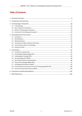
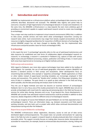
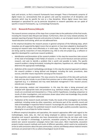
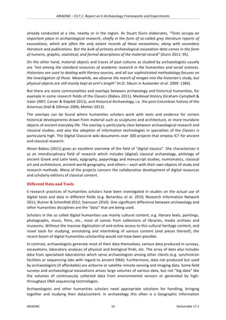
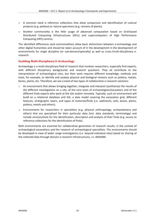
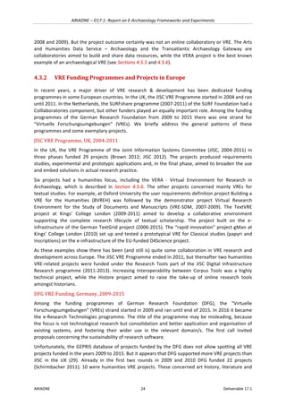
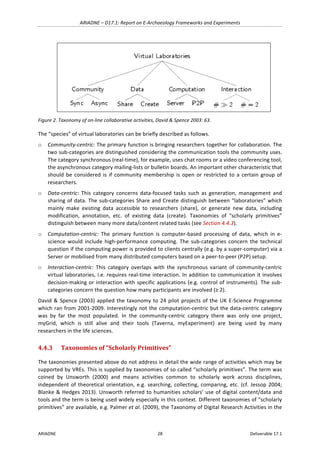
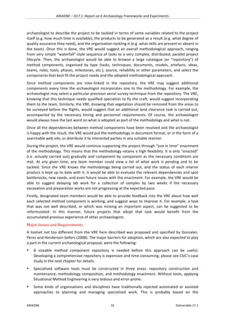
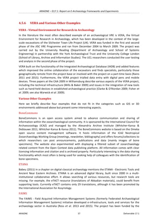
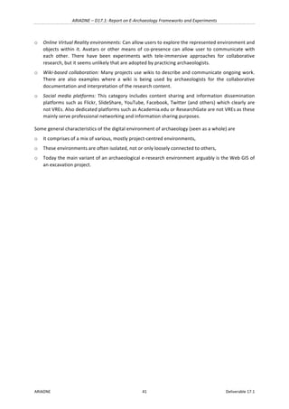
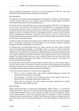
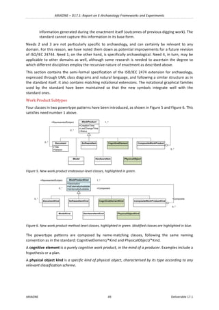
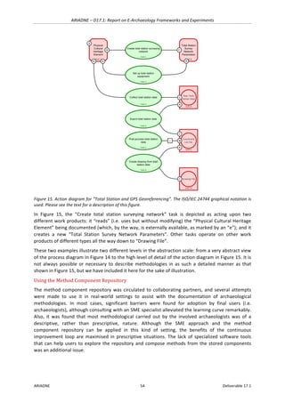
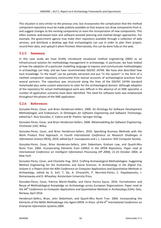
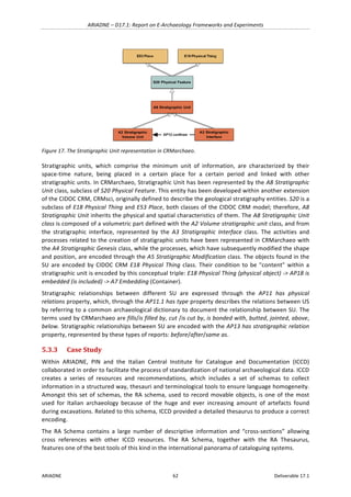
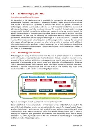
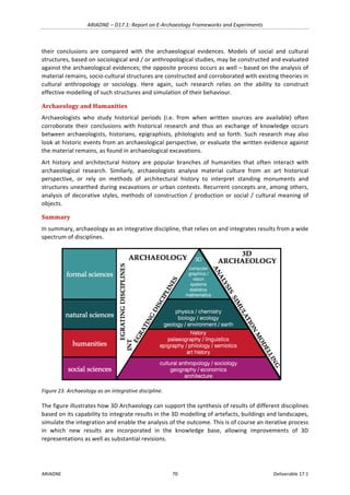
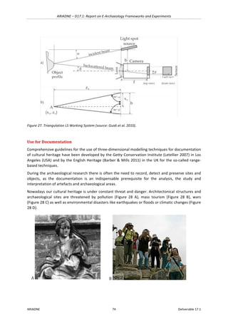
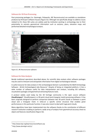
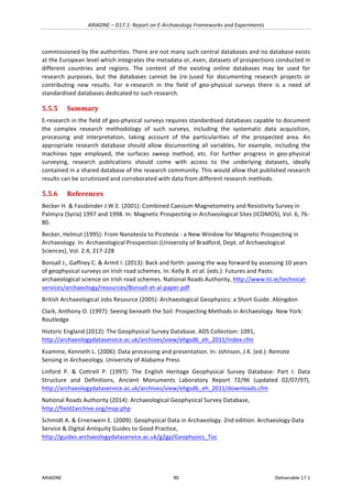
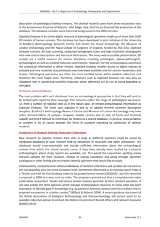
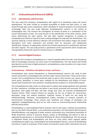
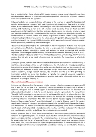
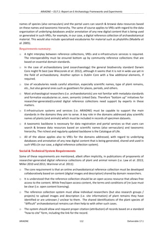
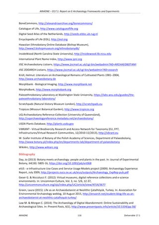
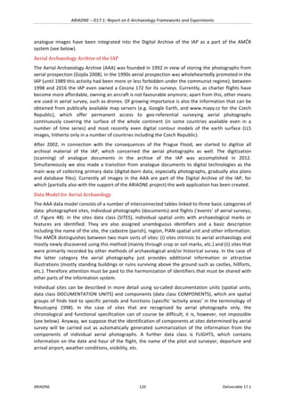
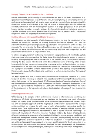
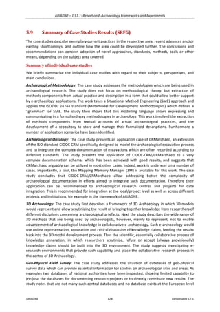
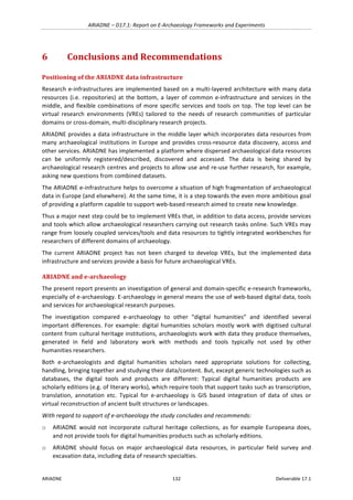
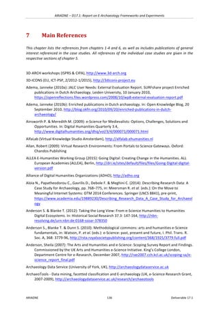
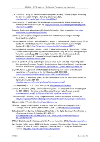
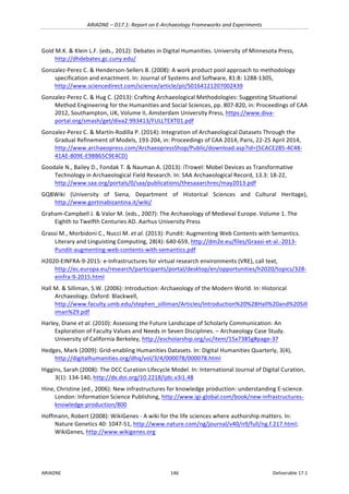
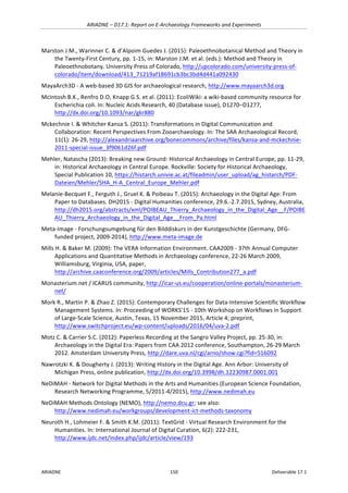
Figure 10. New method-level class and associations for work product states, highlighted in green.
The powertype pattern is composed by name-matching classes, following the same naming
convention as in the standard: WorkProductState/*Kind.
A work product state kind is a specific kind of work product state, characterised by its semantics in
relation to the lifecycle of the associated work product kind.
Note that actions work as the mechanism that entail state transitions for work products within an
endeavour. In this regard, each action may take a particular initial state and produce a particular final
state upon completion. Similarly, action kinds can be used to model what work product kind states
are required upon start and which are ensured upon successful completion.
The different states that a work product kind may be in a particular methodological situation are
depicted as labels in square brackets next to the related action kind circle, as shown in Figure 11.
Figure 11. Notation example for work product states. See the main text for a detailed description.
The "[Raw]" label next to the "C" action kind indicates that the "Export total station data" task kind
ensures that the coordinate list file produced is left in a raw state. The "[Raw] : [Fixed]" label next to
the "M" action kind indicates that the "Post-process total station data" task kind requires that the
coordinate list file to be modified is in a raw state, and ensures that it is left in a fixed state upon
successful completion. The text before the colon indicates a required or taken state, whereas the
text after the colon indicates an ensured or produced state.
+Description
+IsExternallyAvailable
+IsInternallyAvailable
WorkProductKind
+Name
WorkProductStateKind
1 0..*
+Name
Template
+Type
+Optionality
+WorkProductRole
ActionKind
0..*
0..1
Requires4
0..*
0..1
Ensures4
Export total station data
Post-process total station
data
Coordinate
List File
C
M
~
: [Raw]
[Raw] : [Fixed]](https://image.slidesharecdn.com/ariadned17-170522183902/85/Ariadne-Report-on-E-Archaeology-Frameworks-and-Experiments-51-320.jpg)
![ARIADNE – D17.1: Report on E-Archaeology Frameworks and Experiments
ARIADNE 98 Deliverable 17.1
Bernert, Zs. 2005. Paleoanthropological program package [Paleoantropológiai programcsomag]. Folia
Anthropologica, 3, 71–74.
Brickley M. & McKinley J.I. (eds.). 2004. Guidelines to the Standards for Recording Human Remains.
IFA Paper No. 7. BABAO and Institute of Field Archaeologists, UK
Buikstra, J. E., Ubelaker, D. H. (eds) 1994. Standards for data collection from human skeletal remains.
Fayetteville, AR, Archaeological Survey. Research Seminar Series 44.
Éry, K., Kralovánszky, A., Nemeskéri, J. 1963. Történeti népességek rekonstrukciójának
reprezentációja. Anthropológiai Közlemények, 7, 41-90.
Millard, A. & Roberts, C. 2004: BODIES - The British and Irish On-line Database Index to Excavated
human remains. Accessed 2016/07/04 – https://community.dur.ac.uk/a.r.millard/BODIES/
Pap I., Fóthi E., Józsa L., Bernert Zs., Hajdu T., Molnár E., Bereczki Zs., Lovász G., Pálfi Gy. 2004.
Historical Anthropological Protocol for recovering, curation, caring and preliminary anthropological
investigations of the anthropological materials deriving from archaeological excavation. [Történeti
Emebrtani Protokoll a Régészeti Feltárások Embertani Anyagainak Kezelésére, Alapszintű
Feldolgozására és Elsődleges Tudományos Vizsgálatára]. Anthropolgiai Közlemények, 50, 105-123.
Tilley, L. & Cameron, T. (2014): Introducing the Index of Care: A web-based application supporting
archaeological research into health-related care. International Journal of Palaeopathology, 6(1): 5-9.
Tilley, Lorna (2013): Towards a bioarchaeology of care: a contextualised approach for identifying and
interpreting health-related care in prehistory. PhD Thesis, Australian National University.
Tilley, Lorna (2015): Theory and Practice in the Bioarchaeology of Care. New York: Springer.](https://image.slidesharecdn.com/ariadned17-170522183902/85/Ariadne-Report-on-E-Archaeology-Frameworks-and-Experiments-98-320.jpg)
![ARIADNE – D17.1: Report on E-Archaeology Frameworks and Experiments
ARIADNE 101 Deliverable 17.1
the Archaeobotanical Record describes the uptake of data recording (e.g. digital photography),
communication (e.g. online forums) and dissemination tools (e.g. image sharing sites) over the last
30 years and addresses some examples in greater detail (Warinner & d’Alpoim Guedes 2015).
Naomi Miller’s survey (Miller 2010 [appendix]) provides a valuable, very likely still valid indicator of
which kind of web-accessible information archaeobotanists find useful when they are working on a
laboratory analysis and report. The top three of the 54 websites, each with over 10 mentions were:
USDA Plants Database (16), Digital Seed Atlas of the Netherlands (12), and InsideWood (11). The
Atlas may require some explanation: it contains over 4000 full colour digital photographs taken with
a microscope and represents 1828 taxa, mainly of wild plant species. The high-quality images and
descriptions are not only relevant for plant identification of Dutch archaeobotanists (of which 3
participated in the survey), but for many others in Europe and beyond. Most of the other websites
were mentioned by only one or two survey participants: “representative” with regard to the type of
content are regionally focused databases (e.g. Tropicos), seeds characteristics/images (many),
ethnobotany, including plant names (Hawaiian Ethnobotany Online Database), and scientific plant
names (e.g. International Plant Name Index).
5.7.3 Case Study
The case study addresses archaeobotanical research in the context of archaeological sites. This
concerns the investigation of remains of plants as a contribution to the overall interpretation of sites.
The study focuses on the identification of the plant remains, which means determining the plant
species. The task often requires comparison of samples to archaeobotanical reference material as
well as asking colleagues for help with the identification. This could be eased by a virtual reference
collection and environment that collects images and context descriptions from many researchers and
provides tools for discussion and collaborative identification. But such a collection environment is not
easy to build. The case study looks into a number of available options, including a collection
management system (Adlib Museum), a wiki-based environment (MediaWiki), a system for specimen
based biological research projects (Morphbank), the Scratchpads platform, and Paleobot.org, a web-
site developed by a group of archaeobotanists. Based on the results of the case study a specification
of the requirements of an appropriate virtual environment has been developed. The set of
requirements is presented and discussed in next section.
Digital Practices in the Research Process
The case study looks into the process of archaeobotanical research in the context of archaeological
sites. The research process comprises of
o collection of samples of plant remains from excavated soil,
o identification, description and quantification of finds,
o analysis and interpretation of the data,
o writing a report which presents and summarises the results (which are included in an interim or
final report on the excavation), and
o use of the research results for academic publications.
This study mainly addresses digital practices and means which are or could be involved in the
process, leaving aside general purpose tools for tabular data and text. The focus is on digital images
which are very important for the documentation and identification of plant remains. Indeed, digital
images of samples play a key role when archaeobotanists must look for reference specimens or ask
remote colleagues for help with the identification of finds. The main focus of this study is the
identification phase of archaeobotanical studies.](https://image.slidesharecdn.com/ariadned17-170522183902/85/Ariadne-Report-on-E-Archaeology-Frameworks-and-Experiments-101-320.jpg)
![ARIADNE – D17.1: Report on E-Archaeology Frameworks and Experiments
ARIADNE 103 Deliverable 17.1
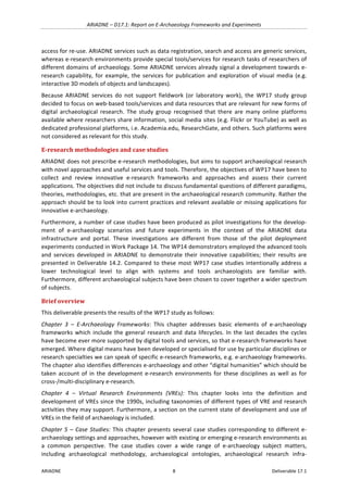
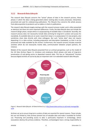
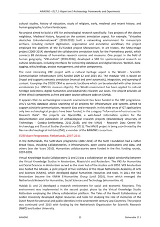
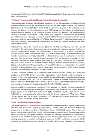
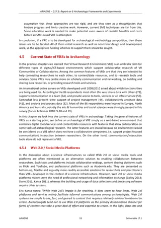
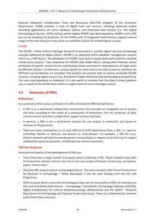
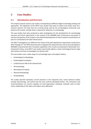
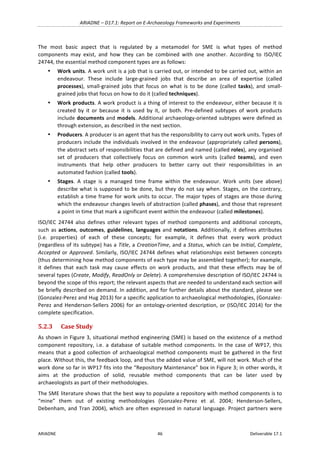
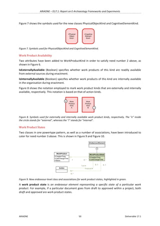
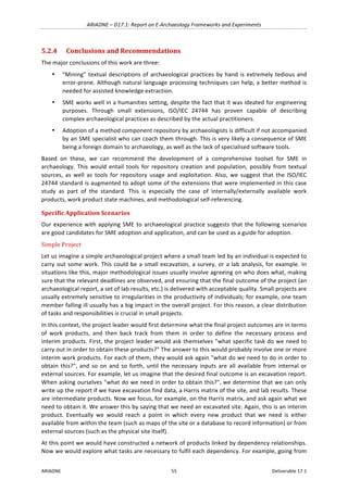
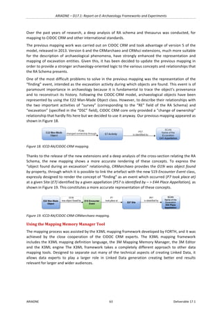
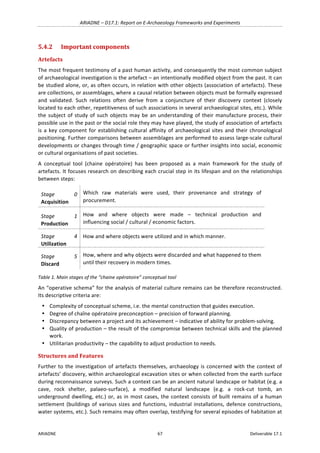
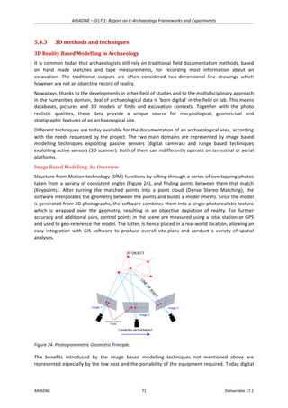
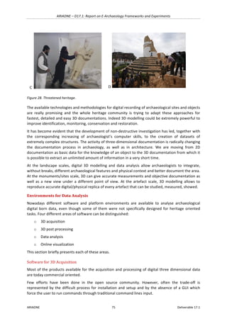
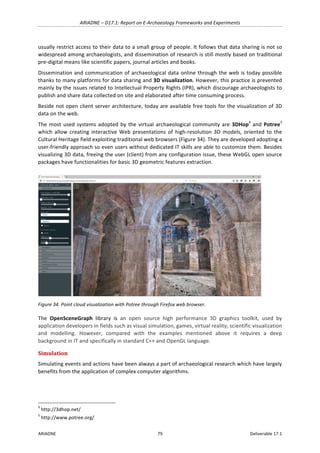
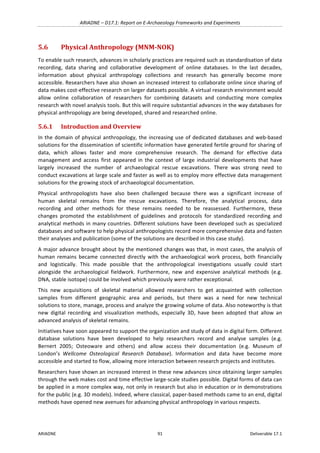
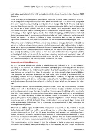
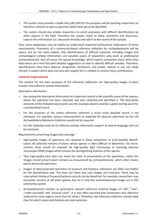
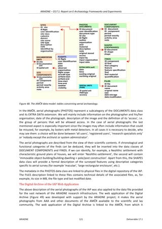
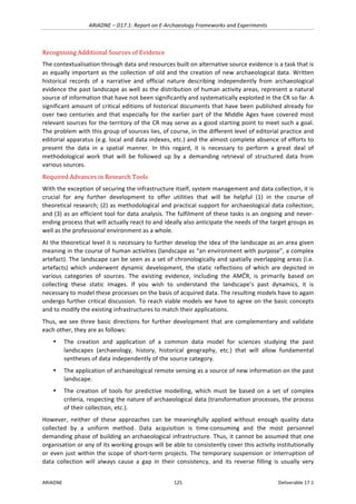
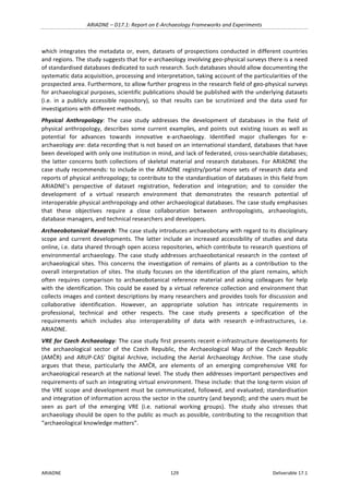
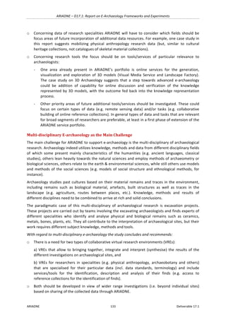
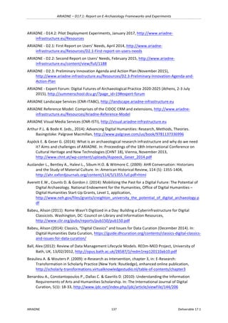
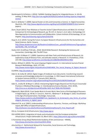
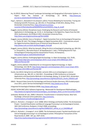
Figure 44. Photographing charred ‘weed’ seeds at
Çatalhöyük. Source: Green 2015.
The set up comprises of a Leica light microscope with a
digital camera on top from which images taken are
transferred via an USB cable onto the laptop; the laptop
is equipped with software for managing the image
collection. In interviews of the eIUS project with
researchers of the large-scale excavations of the
Silchester Town Life Project (UK) an archaeobotanist
described a similar set up. There the microscope images
were also uploaded to a central excavation database and
the researcher could give others a context or sample
number to look them up (eIUS 2009 [interviewee 5]).
“I also spent parts of the day photographing some of the wild taxa that I found, using a special
camera that fits onto the microscope, in order for them to be more accurately identified back in the
UK. Identifying seeds to species can be very time consuming, particularly for wild taxa, and it often
requires a comprehensive modern seed reference collection. Unfortunately, this is not something that
can be brought along with me, nor did I have enough time this visit, so quality photos of the charred
specimens for identification back home are the next best thing. (…) Now back in (rainy) Oxford, I am
currently processing through the many images taken during my fieldwork and sorting them into
different weed types. The lengthy process of identification now begins…” (Green 2015).
Identification as the Main Problem
Identification of the species of the plant remains is the most important phase in the archaeobotanical
research process as all further steps and their outcomes depend on this. According to the Miller
survey it is the main phase in which the researchers face problems (Miller 2010 and 2011). Here the
survey respondents wanted to have better online reference collections/ databases aiding the
taxonomic identification. Also online access to other resources (reports, datasets) was on
respondents’ wish lists. But reference collections/databases for seed and plant part identification,
with adequate specimens, images and description, was clearly the most pressing need. This need was
expressed also by respondents who work in regions where ancient floras are generally well known.
Naomi Miller notes important requirements for appropriate online databases, which “need to be
institutionally and/or communally maintained and should be set up so that content could be added by
individuals”, and emphasises, “what we really need are databases that can be contributed to
collectively by practitioners and that will outlive their creators” (Miller 2010: 3 and 21).
Why Typical Botanical Reference Collections are Often Not Adequate
Since the later 1990s natural history museums, botanical gardens and herbaria have increasingly
digitised and brought online their botanical collection records. These records present and describe
well-preserved specimens, collected for taxonomic and reference purposes, i.e. some are so called
type specimens associated with the authoritative scientific name of the species. Although there have
been quite some efforts to aggregate and integrate botanical reference collections online, many are
still isolated web versions of the institutions’ collection databases. These research resources are in
general openly accessible, but structured in different ways, and varied coverage of species and
regions as well as quality of specimen documentation (images, description, literature references).
However, the core problem in our study context is that records of such online reference collections
are of limited relevance to archaeobotanists. Their visual content is scans of botanical sheets and
drawings or photographs of carefully selected and stored specimens. This content may be helpful in
some cases to identify well-preserved plant remains recovered in excavations. But archaeological](https://image.slidesharecdn.com/ariadned17-170522183902/85/Ariadne-Report-on-E-Archaeology-Frameworks-and-Experiments-103-320.jpg)
![ARIADNE – D17.1: Report on E-Archaeology Frameworks and Experiments
ARIADNE 104 Deliverable 17.1
plant remains typically have undergone processes such as desiccation and carbonization, which can
alter their appearance and often poses a challenge for their taxonomic identification. Therefore,
archaeobotanists need online reference material for such remains with high-quality images,
contextual information, and, ideally, identification keys for such remains.
Warinner et al. (2011) note that the reference material of botanical online collections (e.g. botanical
sheets), “are generally not useful for aiding in the identification of macro- or micro-fossils”. They are
“biased toward common taxa” (i.e. may not include ancient species) and lack the images required for
the identification of such plant remains. With regard to the (few) online resources which contain
images for archaeobotanical research, the authors note that their geographic coverage “is generally
restricted to only a few, mostly Old World, cultural areas”. Archaeobotanists who work in under-
studied regions or are engaged in cross-regional projects will find little for their research online.
Moreover, the existing resources are “heavily biased toward macro-botanical remains”. Micro-
remains such as starch and phytoliths are of course also not covered by standard botanical reference
collections.
Asking colleagues for help
The situation described above raises the question what archaeobotanists do when they are facing
difficult to identify plant remains. The answer of course is asking colleagues for help. There are not
many archaeobotanical specialists around even at a large excavation or institute. Therefore, they
often contact experts of their circle of peers. Before the Internet researchers had to send colleagues
copies of slides of unidentified finds physically by mail or arrange an in-person visit.
One opportunity to ask several colleagues for help directly are dedicated workshops. For example,
the Archaeological Soil Micromorphology Working Group has organised such meetings since the
early 1990s as “hands on” workshops where participants bring thin sections of material for
microscope-based examination, discussion and collaborative identification.
In a focus group interview with archaeologists working on the large-scale excavations of the
Silchester Town Life Project (UK), one archaeobotanist explained: “The way I interact with people is
going to workshops with all my slides. They have them quite regularly, it’s the International Soil
Micromorphology Working Group, which happens usually yearly, so I tend to go to those. Then you
can take all your slides and ask for other people’s opinions. And everyone else brings their slides as
well […]. You could [share the images online], but I think the problem with looking at this stuff online
is that you’re looking at microscope images, so it’s often difficult to interpret something just from a
photograph. […] Because [if you are there] you can look at the slide as a whole, also the person might
have photographs of the site that it’s come from, but I really need to look at the whole slide rather
than just one little bit. [...] I do email backward and forwards the odd photo and ask for their
comments or whatever, but it’s not the same as being there. [...] I email individual people [rather than
mailing lists], I usually know who to target to ask specific things” (eIUS 2009 [interviewee 5])
The Internet provided new ways to ask peers for help by e-mailing close colleagues digital images
and/or post a request to subscribers of a mailing list of the research community.
Mailing Lists
The internationally most widely used mailing list is the JISC Archaeobotany Listserv (over 700
subscribers), which facilitates the exchange of information on all relevant topics. Since 2002,
hundreds of requests for help with identification of plant remains have been posted and, obviously,
useful help has been provided.
Identification requests typically concern one or a few finds and include images, general contextual
information (i.e. region and historical period of the project), and further details relevant for the
identification of the plant remain. Also posters often mention an assumption of what it might be. In](https://image.slidesharecdn.com/ariadned17-170522183902/85/Ariadne-Report-on-E-Archaeology-Frameworks-and-Experiments-104-320.jpg)
![ARIADNE – D17.1: Report on E-Archaeology Frameworks and Experiments
ARIADNE 105 Deliverable 17.1
October 2016, 5 of 14 JISC listserv messages, in November 6 of 18 were such requests for help. Other
messages concerned calls for papers, post doc positions, upcoming workshops, change of e-mail
addresses, etc. Some requests initiated threads of discussion by several experts, others received at
least one suggestion (most often 2-4), and one request concerning seeds from central Thailand by an
American researcher did not get a response.
Below one example of a request and suggestions is presented (without the names, institutional
affiliation, and courtesies of the participants). The request was on the 17th
of October 2016, around 9
am, and the suggestions given during the same day.
ID help Medieval Oslo: “I need help with the identification of two seeds from the Follo Line Project in
Oslo. The first looks a lot like several seeds found in the Lamiaceae family, just not exactly like any
one in my literature. The other is unfamiliar to me, and it is plentiful in only one of our samples. The
scale in the photos is 1 mm”.
Figure 45. Varia
Figure 46. Lamiaceae
R1 [Germany]: “Two seeds of Daphnia in a pod ...
Animal kingdom!”
R2 [Germany]: “Varia are ephippia of Daphnidae /
Daphnia (water fleas), the Lamiaceae could be a
bit corroded Prunella vulgaris, a bit difficult to
identify from the foto”.
Response to R2: “As others have also suggested,
my picture shows dormant Ephippia from Daphnia.
This is very useful to the interpretation of the
structure the sample is taken from. As for the
Lamiaceae, it is not a Prunella. These occur
frequently in my samples, so I’ve had the
opportunity to compare the two”.
R3 [Netherlands]: “I would think towards the
Stachys direction…arvensis/sylvatica?”
R4 [Norway]: “I agree with [R3] for both finds.
Finds of Daphnia are indicators of fresh water
and local hydrology, and thus of help in the
interpretation of past environment.
Response to R3 and R4: “I have compared the
seeds with Stachys in the literature before, and
also with Stachys sylvatica that I have in my
reference collection. They seem a bit too round
to be a match, but still it may be variations
within the species. I have no better suggestion
myself”.
Some interesting aspects of the conversation are: The researcher has an own reference collection
and also uses the literature, but in the case of these rather well preserved two Lamiaceae (of the
mint family of flowering plants) no conclusion was reached, also not with the help of other
specialists. The Daphnia (water fleas), easily identified by two experts, illustrate that
archaeobotanists of course also face remains of animals. For example, a thread in November 2016,
“Euphorbia lathyris?”, discussed the question if images of an (assumed) assemblage of caper spurge
seeds from a late medieval French settlement may not show plant tubers or sheep/goat or rabbit
faecal pellets. The seed and tuber suggestions were refuted.](https://image.slidesharecdn.com/ariadned17-170522183902/85/Ariadne-Report-on-E-Archaeology-Frameworks-and-Experiments-105-320.jpg)
![ARIADNE – D17.1: Report on E-Archaeology Frameworks and Experiments
ARIADNE 110 Deliverable 17.1
o Collection Context: Hearth
o Cultural Affiliation: -800 to -100
o Cultural Period: Iron Age
o Collection Origin: Archaeological Excavation
o Species Native Homeland: Native Species
o Collector: Robert N Spengler III
Seed Macro 1 Macro Seed
o Image Type: Photo
o Image Credit: Self
o Analyst: Robert N Spengler III
o Botanical Part: Seed
[thumbnail image, but a large one is given]
The website and publications of the Paleobot.org team do not mention if the records are based on a
metadata standard. Most specimen records, 47 identified while 23 not, come from the Paleoethno-
botany Laboratory at Washington State University which is led by Jade d'Alpoim Guedes and employs
further five researchers. The laboratory has reference collections and state of the art facilities for the
extraction, identification and interpretation of archaeobotanical materials, including micro-remains
(pollen, phytoliths, starch grains), and stable isotopes of such materials and sediments.
16 other researchers uploaded 42 records of macro-remains, 23 identified and 19 unknown. 141
“profiles” of contributors are listed, many with photo and affiliation, and a link to contributions to
Paleobot.org, but most with none. Importantly, the website does not provide a feature for
annotating or discussing unknown material, also not how to download information. Maybe this is
possible for registered users, but not mentioned under FAQ. The website mentions plans to
supplement the database with additional resources, such as publications, identification guides,
laboratory protocols, and instructional videos. But there is a long list of selected links of herbaria and
online botanical information, websites on macro- and micro-remains, etc.
In summary, the Paleobot.org project must be lauded for providing access to relevant information.
But it has not yet achieved its main objective to bring together the archaeobotany community to
share information and expertise and engage in collaborative identification of unknown specimens.
Linking Records and Discussion
Surprisingly Paleobot.org does not refer contributors to the JISC Archaeobotany mailing list to
possibly receive suggestions for the identification of unknown material. The BoneCommons
zooarchaeology community website (see Section 4.5.6) utilizes the JISC ZOOARCH list for this
purpose. BoneCommons invites researchers to upload identified and unknown samples and in the
latter case post a request for help by specialists. The ZOOARCH list, which has over 1200 subscribers
worldwide, does not allow posting images. But researchers can use the link for the sample record in
the Bone Commons database to point colleagues on the mailing list to the material to be discussed
and identified (there are nearly 300 such “ZOOARCH Attachments”). However, the material on
BoneCommons and the suggestions and discussion on the ZOOARCH list remain separated.
Mckechnie & Whitcher-Kansa (2011) describe the setup and mention that BoneCommons displays a
feed of the discussion threat. Such feeds are not there anymore, maybe too difficult to maintain or
due to other reasons. However, the BoneCommons website notes that a feed of the ZOOARCH
discussion about samples is available via the Zooarchaeology Ning Network (which is a closed
members-only social network). The reasons for this complex setup remain unclear.](https://image.slidesharecdn.com/ariadned17-170522183902/85/Ariadne-Report-on-E-Archaeology-Frameworks-and-Experiments-110-320.jpg)
![ARIADNE – D17.1: Report on E-Archaeology Frameworks and Experiments
ARIADNE 140 Deliverable 17.1
Candela L., Castelli D., Pagano P. & Manzi A. (2014): Realising Virtual Research Environments by
Hybrid Data Infrastructures: the D4Science Experience. International Symposium on Grids and
Clouds (ISGC) 2014, Academia Sinica, Taipei, Taiwan, 23-28 March 2014,
https://b2share.eudat.eu/record/154/files/ISGC2014_022.pdf
Candela, Leonardo (2010): Data Use - Virtual Research Environments, pp. 91-98, in: GRDI2020 -
Global Research Data Infrastructures: Towards a 10-year vision for global research data
infrastructures. GRDI2020 Consortium,
http://www.grdi2020.eu/Repository/FileScaricati/9a85ca56-c548-47e4-8b0e-86c3534ad21d.pdf
Caraher, Bill (2012): Small Archaeological Projects and the Social Context of their Data. In:
MediterraneanWorld weblog, 17 December 2012,
http://mediterraneanworld.wordpress.com/2012/12/17/small-archaeological-projects-and-the-
social-context-of-their-data/
Caraher, Bill (2013): iPads in the Field and Reflections on Archaeology’s Digital Future [Pyla-
Koutsopetria Project]. In: Archaeology of the Mediterranean World weblog, 23 May 2013,
https://mediterraneanworld.wordpress.com/2013/05/23/ipads-in-the-field-and-reflections-on-
archaeologys-digital-future/
Caraher, Bill (2013): Some More Thoughts on Digital History. In: MediterraneanWorld weblog, 7
January 2013, http://mediterraneanworld.wordpress.com/2013/01/07/2382/
CARE - Corpus architecturae religiosae europeae, IV-X saec., http://care.huma-num.fr
Carusi A. & Jirotka M. (2010): Reshaping Research Collaboration: The case of Virtual Research
Environments, pp. 277-294, in: Dutton W.H. & Jeffreys P.W. (eds.): World Wide Research:
Reshaping the Sciences and Humanities. Cambridge, MA: The MIT Press
Carusi A. & Reimer T. (2010): Virtual Research Environment - Collaborative Landscape Study. A JISC
funded study. Oxford e-Research Centre and Centre for e-Research, King's College London,
http://www.jisc.ac.uk/media/documents/publications/vrelandscapereport.pdf
Carver M.O.H. & Klápštĕ J. (eds., 2011): The Archaeology of Medieval Europe. Volume 2: Twelfth to
Sixteenth Centuries. Aarhus University Press
Cayless H., Roueché C., Elliott T. & Bodard G. (2009): Epigraphy in 2017. In: Digital Humanities
Quarterly, Winter 2009 (Special Issue: Changing the Center of Gravity: Transforming Classical
Studies Through Cyberinfrastructure),
http://www.digitalhumanities.org/dhq/vol/3/1/000030.html
centerNet - An international network of digital humanities centers, http://dhcenternet.org/
CHARM - Cultural Heritage Abstract Reference Model (Cesar Gonzalez-Perez et al., Institute of
Heritage Sciences [Incipit], Spain), http://www.charminfo.org
Chevalier P., Leclercq E., Millereux, A., Sapin C. & Savonnet M. (2013): WikiBridge: a Semantic Wiki
for Archaeological Applications, pp. 259-265, in: CAA 2010 - Proceedings of the 38th Conference
on Computer Applications and Quantitative Methods in Archaeology, Granada, Spain, April
2010. Oxford: Archaeopress 2013, https://publikationen.uni-
tuebingen.de/xmlui/handle/10900/60840
CIDOC Conceptual Reference Model (CIDOC CRM), http://www.cidoc-crm.org
Clarke A. & O’Riordan E. (2009): Managing Change: Introducing innovation into well-established
systems. CAA2009 - 37th Annual Computer Applications and Quantitative Methods in
Archaeology conference, 22-26 March 2009, Williamsburg, Virginia, USA, paper,
http://archive.caaconference.org/2009/articles/Clarke_Contribution203_a.pdf](https://image.slidesharecdn.com/ariadned17-170522183902/85/Ariadne-Report-on-E-Archaeology-Frameworks-and-Experiments-140-320.jpg)
![ARIADNE – D17.1: Report on E-Archaeology Frameworks and Experiments
ARIADNE 142 Deliverable 17.1
David P.A. & Spence M. (2003): Towards Institutional Infrastructures for e-Science: The Scope of the
Challenge. Final Report to the Joint Information System Committee of the UK Research Councils,
Oxford Internet Institute, Research Report No. 2,
http://www.oii.ox.ac.uk/resources/publications/OIIRR_E-Science_0903.pdf
Dávidházi, Péter (ed., 2014): New Publication Cultures in the Humanities: Exploring the Paradigm
Shift. Amsterdam UP, https://oapen.org/download?type=document&docid=515678
Day, Jo (2013): Botany meets archaeology: people and plants in the past. In: Journal of Experimental
Botany, 64(18): 5805-16, https://doi.org/10.1093/jxb/ert068
DCCD - Digital Collaboratory for Cultural Dendrochronology, http://dendro.dans.knaw.nl
de Kleijn M., de Hond R., Martinez-Rubi O. & Svetachov P. (2015): A 3D Geographic Information
System for ‘Mapping the Via Appia’. Research Memorandum 2015-1, Vrije Universiteit
Amsterdam,
https://www.academia.edu/10511048/A_3D_Geographic_Information_System_for_Mapping_t
he_Via_Appia
de la Flor G., Luff P., Jirotka M., Pybus J., Kirkham R. & Carusi A. (2010): The Case of the Disappearing
Ox: Seeing Through Digital Images to an Analysis of Ancient Texts, pp. 473-482, in: Proceedings
of the 28th ACM Conference on Human Factors in Computing Systems (CHI 2010), Atlanta, USA,
http://ora.ox.ac.uk/objects/uuid:8c4181f2-88c5-497d-9485-bc0e7a6d7b5e
Deegan M. & McCarty W. (eds., 2012): Collaborative Research in the Digital Humanities. Ashgate
Deelman E., Gannon D., Shields M. & Taylor I. (2009): Workflows and e-Science: An overview of
workflow system features and capabilities. In: Future Generation Computer Systems, 25(5): 528-
540; preprint, https://www.researchgate.net/publication/220284915_Workflows_and_e-
Science_An_overview_of_workflow_system_features_and_capabilities
Degryse P. & Shortland A.J. (2013): Nourishing archaeology and science. In: PNAS - Proceedings of the
National Academy of Sciences of the United States of America, 110(51),
https://lirias.kuleuven.be/bitstream/123456789/437071/1/PNAS-2013-Degryse-20352-3.pdf
DHCommons initiative (centerNet), http://dhcommons.org
Digging into Data Challenge, http://diggingintodata.org
Digital Classicist wiki: Projects (ancient and classical research projects applying ICT),
https://wiki.digitalclassicist.org/Category:Projects
Digital Classicist, http://www.digitalclassicist.org
Digital Curation Centre (UK): Curation Lifecycle Model [accessed 21/11/2016],
http://www.dcc.ac.uk/resources/curation-lifecycle-model
Digital Curation Centre (UK): What is digital curation? [accessed 21/11/2016],
http://www.dcc.ac.uk/digital-curation/what-digital-curation
Digital Humanities Conference, http://adho.org/conference
Digital Humanities Quarterly (since 2007), http://www.digitalhumanities.org/dhq/
Digital Karnak (University of California, Los Angeles), http://dlib.etc.ucla.edu/projects/Karnak/
Digital Roman Forum (University of California, Los Angeles), http://dlib.etc.ucla.edu/projects/Forum
DiRT (Digital Research Tools) directory, http://dirtdirectory.org
DM2E - Digital Manuscripts to Europeana (EU, ICT-PSP, 2/2012-1/2015), http://dm2e.eu](https://image.slidesharecdn.com/ariadned17-170522183902/85/Ariadne-Report-on-E-Archaeology-Frameworks-and-Experiments-142-320.jpg)
![ARIADNE – D17.1: Report on E-Archaeology Frameworks and Experiments
ARIADNE 151 Deliverable 17.1
NRC-CSTB – National Research Council, Computer Science and Telecommunications Board (1993):
National Collaboratories: Applying Information Technology for Scientific Research. Washington,
D.C.: National Academy Press, http://www.nap.edu/catalog/2109/national-collaboratories-
applying-information-technology-for-scientific-research
O’Donnell D.P., Singh G. & Rosselli Del Turco R. (2015): The Old Familiar Faces: On the Consumption
of Digital Scholarship. DH2015 - Digital Humanities conference, Sydney, Australia,
http://dh2015.org/abstracts/xml/O_DONNELL_Daniel_Paul_The_Old_Familiar_Faces__On_/O_
DONNELL_Daniel_Paul_The_Old_Familiar_Faces__On_The_Co.html
OCHRE - Online Cultural Heritage Research Environment (Oriental Institute, University of Chicago,
USA), https://ochre.uchicago.edu
Olson G.M., Zimmerman A. & Bos N. (eds., 2008): Scientific Collaboration on the Internet. Cambridge,
Mass.: MIT Press
Open Context (Alexandria Archive Institute, USA), https://opencontext.org
OpenInfRA - An Open Information System for Research in Archaeology (Germany, Brandenburg
University of Technology - Cottbus-Senftenberg, DFG-funded project, 2011-2016),
https://www.b-tu.de/openinfra/
Ostia - Harbour City of Ancient Rome 194 (community project), http://www.ostia-antica.org
Palmer C.L., Teffeau L.C. & Pirmann C.M. (2009): Scholarly information practices in the online
environment. Dublin, OH: OCLC,
http://www.oclc.org/content/dam/research/publications/library/2009/2009-02.pdf
Pearsall, Deborah M. (2016): Paleoethnobotany: A Handbook of Procedures. Third Edition. Routledge
Pegasus (workflow management system), https://pegasus.isi.edu/applications
Plan de Rome (Université de Caen Basse-Normandie, France),
https://www.unicaen.fr/cireve/rome/index.php
Pokorná A., Dreslerová D., Křivánková D. (2011): Archaeobotanical Database of the Czech Republic,
an Interim Report. [includes an overview of the content of the database around 2010]. In:
Interdisciplinaria Archaeologica - Natural Sciences in Archaeology (IANSA) 1/II, 49-53,
http://www.iansa.eu/papers/IANSA-2011-01-pokorna.pdf
Pompey Project (Kings’ College London), http://www.pompey.cch.kcl.ac.uk
Porter, Dorothy (2013): Medievalists and the Scholarly Digital Edition. In: Scholarly Editing - The
Annual of the Association for Documentary Editing, Vol. 34,
http://www.scholarlyediting.org/2013/essays/essay.porter.html
PRACE - Partnership for Advanced Computing in Europe, http://www.prace-project.eu
PRACE / Guest M. et al. (2012): The Scientific Case for HPC in Europe. PRACE, October 2012,
http://www.prace-ri.eu/IMG/pdf/prace_-_the_scientific_case_-_full_text_-.pdf
PRACE-RI - Research Infrastructure (since 2010), http://www.prace-ri.eu
Prilusky J. & Sussman J.L. (2016): Presenting Proteopedia for sharing macromolecule concepts
online. eLife Labs weblog, 29 June 2016, https://elifesciences.org/elife-news/elife-labs-
presenting-proteopedia-sharing-macromolecule-concepts-online
Procter R., Williams R., Stewart J. et al. (2010a): If you build it, will they come? How researchers
perceive and use web 2.0. London: Research Network Information,
http://wrap.warwick.ac.uk/56246/](https://image.slidesharecdn.com/ariadned17-170522183902/85/Ariadne-Report-on-E-Archaeology-Frameworks-and-Experiments-151-320.jpg)
![ARIADNE – D17.1: Report on E-Archaeology Frameworks and Experiments
ARIADNE 154 Deliverable 17.1
Evidence for Human and Natural history. SAGVNTVM, Extra 13, Universitat de València,
Departament de Prehistòria i d’Arqueologia,
https://www.sapac.es/charcoal/saguntum/extra13/se13_291.pdf
Stuijts, Ingelise (2012): Cloud-computing in anthracology – developing the WODAN online database
in Ireland. Presentation at Archaeological and Historical Wood Utilization meeting, Egmond aan
Zee, 29 Sept. 2012, http://holzverwendung.boku.ac.at/dokumente/secondworkshop/Stuijts.pdf
Svensson, Patrik (2010): The Landscape of Digital Humanities. In: Digital Humanities Quarterly, 4.1,
http://www.digitalhumanities.org/dhq/vol/4/1/000080/000080.html
Svensson, Patrik (2011): From Optical Fiber to Conceptual Cyberinfrastructure. In: Digital Humanities
Quarterly, 5.1, http://digitalhumanities.org/dhq/vol/5/1/000090/000090.html
Swedish Pompeii Project, http://www.pompejiprojektet.se
TaDiRAH - Taxonomy of Digital Research Activities in the Humanities (v. 0.5.1, 05/2014), available on
Github, https://github.com/dhtaxonomy/TaDiRAH
Talia, Domenico (2013): Workflow Systems for Science: Concepts and Tools. In: ISRN Software
Engineering, Volume 2013, Article ID 404525,
https://www.researchgate.net/publication/258393324_Workflow_Systems_for_Science_Conce
pts_and_Tools
Terras M., Nyhan J. & Vanhoutte E. (2013): Defining Digital Humanities. A Reader. Ashgate,
http://www.ashgate.com/isbn/9781409469636
TextGrid - Virtuelle Forschungsumgebung für die Geisteswissenschaften (BMBF-funded, 2016-2015),
https://textgrid.de/en/
TextVRE (UK, JISC VRE project, Kings’ College London, 2009-2011),
http://www.kcl.ac.uk/artshums/depts/ddh/research/projects/completed/text.aspx
Thaller, Manfred (ed.): The Cologne Dialogue on Digital Humanities 2012 – Controversies around the
Digital Humanities, http://www.cceh.uni-koeln.de/events/CologneDialogue
The Digital Archaeological Record – tDAR (Digital Antiquity, USA), https://www.tdar.org
The Royal Society (2011): Knowledge, Networks and Nations: Global scientific collaboration in the
21st century, RS Policy document 03/11, March 2011,
http://www.interacademies.net/File.aspx?id=25069
The Royal Society (2012a): Science as an Open Enterprise. Final Report, June 2012,
https://royalsociety.org/policy/projects/science-public-enterprise/Report/
Transatlantic Archaeology Gateway – TAG (Archaeology Data Service [UK] and Digital Antiquity [USA],
2009-2011), http://archaeologydataservice.ac.uk/research/tag
tranScriptorium (EU, FP7, ICT for access to cultural resources, 1/2013-12/2015), http://transkribus.eu
Trognitz M., Niven K., Gilissen V. et al. (2016): 3D Models in Archaeology (Guide, November 2016). In:
Archaeology Data Service & Digital Antiquity: Guides to Good Practice,
http://guides.archaeologydataservice.ac.uk/g2gp/3d_Toc
UCL & Emerald - University College London & Emerald Group Publishing Ltd (2010): Social media and
research workflow (14 December 2010), http://ciber-research.eu/download/20101111-social-
media-report.pdf
UK Data Archive (n.y.): Research data lifecycle, http://www.data-archive.ac.uk/create-manage/life-
cycle](https://image.slidesharecdn.com/ariadned17-170522183902/85/Ariadne-Report-on-E-Archaeology-Frameworks-and-Experiments-154-320.jpg)
![ARIADNE – D17.1: Report on E-Archaeology Frameworks and Experiments
ARIADNE 155 Deliverable 17.1
Unsworth, John M. (2000): Scholarly Primitives: what methods do humanities researchers have in
common, and how might our tools reflect this? Part of a symposium on Humanities Computing:
Formal Methods, Experimental Practice, King’s College, London, 13 May 2000,
http://people.brandeis.edu/~unsworth/Kings.5-00/primitives.html
van der Vaart, Lilian (2010): Collaboratories: Connecting Researchers. How to facilitate choice, design
and uptake of online research collaboratories. April 2010. Utrecht: SURFfoundation,
https://www.surf.nl/binaries/content/assets/surf/en/knowledgebase/2010/Collaboratories+Co
nnecting+Researchers9april.pdf
Van Zundert, Joris (2012): If You Build It, Will We Come? Large Scale Digital Infrastructures as a Dead
End for Digital Humanities. In: Historical Social Research, 37(3): 165-86, http://www.cceh.uni-
koeln.de/files/vanZundert_0.pdf
ViBRANT - Virtual Biodiversity Research and Access Network for Taxonomy (EU, FP7,
Infrastructures/Virtual Research Communities, CP-CSA, 12/2010-11/2013), http://vbrant.eu
Virtual Knowledge Studio (Amsterdam), http://virtualknowledgestudio.nl
Virtuelles deutsches Urkundennetzwerk (Germany, DFG funded project, 2010-2013, now part of
Monasterium.net), www.vdu.uni-koeln.de
VI-SEEM - VRE for regional Interdisciplinary communities in Southeast Europe and the Eastern
Mediterranean (H2020, EINFRA-9-2015 - e-Infrastructures for virtual research environments,
10/2015-9/2018), https://vi-seem.eu
VKLandLab – Spatio-temporal Landscape Research in a Virtual Research Environment (Germany, DFG
funded project, 2010-2014), http://www.vklandlab.uni-rostock.de/en/
von Schwerin J., Lyons M., Loos L., Billen N., Auer M. & Zipf A. (2016): Show me the data!: Structuring
archaeological data to deliver interactive transparent 3D reconstructions in a 3D WebGIS, pp.
198-230, in: Münster S. et al. (eds.): 3D Research Challenges in Cultural Heritage II. Springer
(LNCS 10025)
Voß A. & Procter R.N. (2009): Virtual research environments in scholarly work and communications.
In: Library Hi Tech, 27(2): 174-190; manuscript,
https://www.researchgate.net/publication/220364202_Virtual_research_environments_in_sch
olarly_work_and_communications
VRE-SDM - Virtual Research Environment for the Study of Documents and Manuscripts (UK, JISC VRE
project, Oxford University, 2007-2009), http://bvreh.humanities.ox.ac.uk/VRE-SDM
Waldrop, Mitchell (2008): Big data: Wikiomics. In: Nature 455: 22-25,
http://www.nature.com/news/2008/080903/full/455022a.html
Wallrodt, John (2013): Beyond Tablet Computers as a Tool for Data Collection: Three Seasons of
Processing and Curating Digital Data in a Paperless World [PARP:PS project]. In:
Paperlessarchaeology.com, weblog, 25 March 2013,
http://paperlessarchaeology.com/2013/03/25/beyond-tablet-computers-as-a-tool-for-data-
collection-three-seasons-of-processing-and-curating-digital-data-in-a-paperless-world/
Warwick C., Fisher C., Terras M. et al. (2009): iTrench: A Study of User Reactions to the use of
Information Technology in Field Archaeology. In: Literary and Linguistic Computing, 24(2): 211-
223; manuscript, http://discovery.ucl.ac.uk/13916/1/13916.pdf
Warwick C., Terras M. & Nyhan J. (eds., 2012): Digital Humanities in Practice. London: fact publishing
Whitcher-Kansa S. & Deblauwe (2011): User-Generated Content in Zooarchaeology: Exploring the
“Middle Space” of Scholarly Communication, pp. 185-2006, in: Kansa E. et al. (eds.):](https://image.slidesharecdn.com/ariadned17-170522183902/85/Ariadne-Report-on-E-Archaeology-Frameworks-and-Experiments-155-320.jpg)

The document is the 'Report on e-archaeology frameworks and experiments' under the ARIADNE project, funded by the European Commission, detailing the use of web-based tools and digital services in archaeological research. It analyzes existing e-archaeology frameworks, virtual research environments (VREs), and presents case studies on various topics within archaeology to advance collaborative research. Recommendations for improving e-archaeology through VREs and other digital methodologies are also provided, addressing challenges and suggesting the development of more integrated research solutions.


![[DSC Europe 25] Andrzej Kowalczyk - AI - how to start small and grow in the f...](https://cdn.slidesharecdn.com/ss_thumbnails/oy1zmo94qv6vpcqjvno2-andrzej-kowalczyk-ai-how-to-start-small-and-grow-in-the-future-1-260119121559-cf093b23-thumbnail.jpg?width=640&height=640&fit=bounds)


![[DSC Europe 25] Tali Fulman - Guild Meetings, Then What? Building Data Commun...](https://cdn.slidesharecdn.com/ss_thumbnails/fgohhi33rwmhqdowdj5k-tali-fulman-guild-meetings-then-what-building-data-communities-that-actually-ch-260120105855-528492c3-thumbnail.jpg?width=640&height=640&fit=bounds)


![[DSC Europe 25] Jovan Sumarac - Real-World Applications of Computer Vision in...](https://cdn.slidesharecdn.com/ss_thumbnails/fiksms22smcpopvvld03-jovan-sumarac-real-life-applications-of-computer-vision-in-automotive-systems-260120105855-de622abb-thumbnail.jpg?width=640&height=640&fit=bounds)
![[DSC Europe 25] Milos Belcevic - Product Professional's Journey to Full-Stack...](https://cdn.slidesharecdn.com/ss_thumbnails/1zovd6fgsycdg4wvgvls-milos-belcevic-product-professionals-journey-to-full-stack-product-developer-260123083019-d993120d-thumbnail.jpg?width=640&height=640&fit=bounds)


![[DSC Europe 25] Borko Kozomora - Optimizing business workflows with advances ...](https://cdn.slidesharecdn.com/ss_thumbnails/hbgekyb0txw0xpo4yfml-borko-kozomora-leading-ai-transformation-260122103838-cc29ee38-thumbnail.jpg?width=640&height=640&fit=bounds)