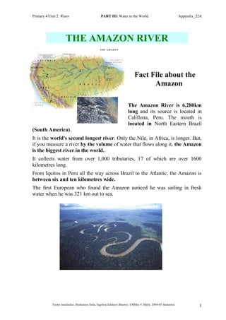
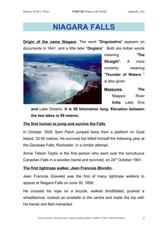
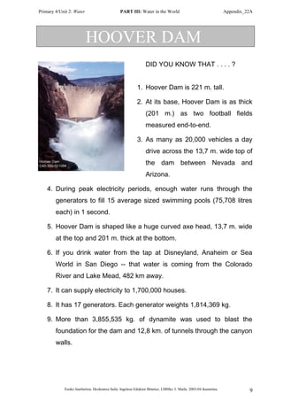
The document provides information about several major rivers and waterfalls around the world. It describes key facts like the length, source, volume of water, and other details. The largest rivers discussed are the Amazon (longest by volume of water), Nile (longest overall), and Mississippi. The tallest waterfall is Angel Falls in Venezuela, followed by Victoria Falls on the Zambia/Zimbabwe border. Other iconic water features mentioned include Niagara Falls, the Grand Canyon, and man-made dams like the Hoover Dam and Aswan High Dam.
The document summarizes the ports of call on a 1996 Semester at Sea voyage that took students around the world. It began in Nassau, Bahamas and continued through Venezuela, Brazil, South Africa, Kenya, India, Vietnam, the Philippines, Hong Kong, Japan, and ended in Seattle, USA. For each port, there are 1-2 paragraphs describing highlights and places visited, including historical sites, natural features, and cultural experiences.
The document summarizes three military bases visited by Ashley O'Dell in the past year:
1) Quantico, Virginia on the Potomac River, established in 1917 to train Marine officers close to Washington D.C.
2) Naval Air Station Pensacola, Florida on the Gulf Coast known for training pilots and housing the National Museum of Naval Aviation and Blue Angels.
3) Vance Air Force Base in Enid, Oklahoma located on the plains prone to tornadoes, established during WWII to train Navy, Marine, and Air Force pilots.
This document summarizes a semester abroad program through Semester at Sea in 1996. Students traveled on a ship called the SS Universe Explorer, visiting 10 ports including Nassau, Bahamas; La Guairá, Venezuela; Salvador, Brazil; Cape Town, South Africa; Mombasa, Kenya; Madras, India; Ho Chi Minh City, Vietnam; Manila, Philippines; Hong Kong; Kobe, Japan; and concluding in Seattle, WA. At each port, students learned about the local culture, history and geography through lectures and excursions.
'The United States Of America'
this work shows the most famous attractions of usa, america it is very beneficial for the people who are interested in visit the fabulous country America
The document summarizes the history of building two important water infrastructure projects: the Los Angeles Aqueduct and the Panama Canal. It describes how William Mulholland addressed Los Angeles' lack of water by constructing an aqueduct to divert water from the Owens River over 200 miles away. It also outlines the multiple attempts to build a canal through Panama, first by the French who failed due to disease and lack of technology, before the U.S. eventually succeeded in the early 1900s after taking control of the Panama region. Both projects transformed their respective regions by overcoming geographical and technical challenges to provide crucial water resources.
The document summarizes the history of building two important water infrastructure projects: the Los Angeles Aqueduct and the Panama Canal. It describes how William Mulholland realized Los Angeles needed a new water source, and oversaw the construction of the Los Angeles Aqueduct to bring water over 200 miles from the Owens Valley. It also outlines the early failed French attempt to build the Panama Canal, and how the U.S. later took over the project, using new technologies and machinery to overcome diseases and terrain challenges to complete the canal by 1914, linking the Atlantic and Pacific Oceans.
Lake Superior is nicknamed "Big Water" by the Ojibwe Indians and is referenced in Longfellow's poem Song of Hiawatha. It has a surface area greater than several New England states combined and contains 10% of the world's surface fresh water. Storms can produce waves up to 30 feet tall on Lake Superior, which contains some of the oldest and clearest fresh water on Earth.
El día del periodista en Colombia se celebra el 9 de febrero para honrar a los periodistas que han sacrificado sus vidas y paz reportando corrupción, tráfico de drogas y otros problemas que afectan negativamente al país. Gracias al trabajo valiente de estos periodistas, Colombia ha podido exponer malos manejos del gobierno y luchar contra fuerzas que desestabilizan la democracia. El día del periodista debería recordar a aquellos hombres y mujeres periodistas que han dado tanto por construir una nación más justa y con instituciones respetadas
Geometría i – unidad 7 – tema 1 – actividad de aprendizaje chávez ibarrakarla...Karla Ximena
La unidad trata sobre curvas de segundo grado como curvas cuadráticas de Bézier y esferas, incluyendo cómo dibujar una esfera usando meridianos en 3D, en isometría y con circunferencias paralelas. También incluye dibujar un hiperboloide de un manto.
The document provides vocabulary and expressions related to weather forecasting. It includes terms for temperature, precipitation, wind, clouds, and descriptive words for weather conditions. Examples of vocabulary include hot, mild, warm, cool, cold, rain, snow, breeze, gale, and directions like north, south, east, west. Expressions defined include km/h for kilometres per hour, oC for degrees Celsius, and mm for millimetres. Phrases are given for describing common weather conditions like "It's sunny" or "It's raining."
Dokumen tersebut memberikan informasi tentang penggunaan fitur-fitur Microsoft PowerPoint seperti menambahkan animasi, suara, dan video serta cara mempresentasikan presentasi PowerPoint.
Este documento resume la evolución de las sociedades desde las primitivas hasta las modernas. Comienza analizando las sociedades preestatales primitivas como las de cazadores-recolectores y las agrarias, caracterizadas por la economía y organización. Luego examina el surgimiento de las sociedades con estado, incluyendo las antiguas, medievales y modernas, distinguidas por su estructura económica y social. Finalmente, describe elementos clave de la estructura social como individuos, roles, estatus, grupos e instituciones que dan
Este cuento trata sobre un pajarito muy perezoso. Cuando llegó el otoño y los demás pájaros se prepararon para su viaje de invierno a un lugar más cálido, el pajarito perezoso lo dejó todo para última hora y se quedó solo. Tuvo que sobrevivir solo el invierno preparando con esfuerzo su nido y alimentos. En la primavera, sus amigos se sorprendieron al encontrarlo vivo. El pajarito había aprendido su lección y ya no era perezoso, convirtiéndose en
Drug (Anti-Psychotic drug) Induce ParkinsonismZulcaif Ahmad
A patient presented with symptoms of drug-induced Parkinsonism including tremors, bradykinesia, and loss of balance after taking the antipsychotic drug haloperidol for 6 months. Diagnostic tests including a DAT scan confirmed dopamine receptor degeneration due to long-term haloperidol use. The patient was diagnosed with drug-induced Parkinsonism and treated by withdrawing haloperidol, starting domperidone for symptoms, and using clozapine. Clozapine has multiple mechanisms of action including antagonism of serotonin and dopamine receptors that differentiate it from typical antipsychotics.
Los animales del bosque celebraron una carrera para ganar frutas como premio. La jirafa se burló del león por llevar solo una fruta. En la carrera, la jirafa se atoró en un árbol, el elefante se cansó a mitad de camino y el borrego se detuvo a recoger un dulce. El león fue el único que terminó la carrera y ganó las 8 frutas como premio, las cuales compartió generosamente con todos los demás animales.
This document provides summaries of 10 important rivers around the world. It begins with the Sepik River in New Guinea, then discusses the Mississippi River in the US, the Volga River in Russia, the Zambezi River in southern Africa, the Mekong River in Southeast Asia, the Ganges River in India, the Danube River in Europe, the Yangtze River in China, the Nile River in northern Africa, and concludes with the Amazon River which flows through South America. For each river, it provides key details about the river's length, location, importance, and in some cases wildlife.
Shell, Ecuador is located in the Ecuadorian rainforest between the Andes and Amazon, accessible via a dangerous road. It was originally a Shell Oil base in 1937 but was abandoned in 1948 due to hostilities from the Huaorani tribe. Missionaries later established operations in Shell, making contact through air drops. In the 1950s, several missionaries were killed by the Huaorani. Today, Shell has a small population and is surrounded by diverse wildlife in the rainforest, accessible via long hikes with waterfalls and a natural waterslide.
The document summarizes 10 major rivers around the world, including their locations and key features. The Amazon River is highlighted as the second longest and largest by volume, flowing through South America. The Nile River is the longest and crucial to Egypt's civilization. The Yangtze River is the longest in China and hosts the largest hydroelectric dam. The Danube flows through several European capitals. The Ganges is considered holy in Hinduism. The Mekong supports rich biodiversity but species are endangered. The Zambezi features Victoria Falls. The Volga is the longest river in Europe. The Mississippi drains much of the central US. The Sepik River winds through Papua New Guinea with isolated tribes possessing unique
The document provides an overview of physical geography concepts and outlines the agenda for an upcoming class. The class will examine how physical geography can influence culture by studying tools geographers use to understand relationships between people, places, and environments. Students will locate major landforms and cities on a world map and complete individual research on how a physical landform has impacted culture.
Lake Superior is the largest of the Great Lakes by surface area. The Ojibwe Indians named it Gichigami meaning "big water." It has a surface area greater than several U.S. states combined and contains 10% of the world's surface fresh water. Some of the oldest rocks in the world can be found on its shores and it provides many recreational activities while also being home to shipwrecks and massive storms due to its size.
Lake Superior is the largest of the Great Lakes by surface area, containing 10% of the earth's fresh surface water. Named Gichigami by the Ojibwe Indians meaning "big water", it has a surface area greater than several U.S. states combined and contains 3 quadrillion gallons of water. With underwater visibility up to 100 feet and waves reaching 30 feet, Lake Superior is renowned for its clarity, size, and power.
The document provides information on various geographical topics around the world including:
- The sizes of several countries and their total areas.
- Details on some of the longest rivers in the world such as their lengths and locations.
- Sizes and locations of some of the largest lakes and seas.
- Locations and brief descriptions of some famous deserts.
- Descriptions of characteristics of some notable volcanoes around the world including their heights and locations.
- Information on some of the tallest mountains globally including Mount Everest.
- A list of some famous world heritage sites.
- Population figures for some of the most and least populated countries.
- Names and descriptions of the currencies of several countries
The document discusses the River Nile and the Aswan Dam project in Egypt. It provides background on the River Nile, including its source and length. It then describes the construction of the Aswan Dam in the 1950s-1960s to generate hydroelectric power, store water for irrigation, and regulate flooding. The dam created Lake Nasser, one of the world's largest man-made reservoirs. While the dam had benefits, it also caused problems like reduced flooding in river deltas. The Soviet Union provided major financial support for the massive infrastructure project led by Egyptian President Gamal Abdel Nasser.
The document is describing the Grand Canyon. It is 277 miles long, up to 18 miles wide, and over a mile deep. It was carved out over a long period of time by the Colorado River. The Grand Canyon exposes uplifted rock layers and is located in the northwest corner of Arizona. It receives most visitors at the South Rim, which is open all year, while the North Rim has more limited access.
Lake Victoria is one of the largest lakes in Africa, located mainly in Tanzania and Uganda but also bordering Kenya. It was named after Queen Victoria by the explorer John Hanning Speke in 1858. Lake Victoria has an area of 68,800 km2 and a maximum depth of 81 meters. It contains over 200 species of fish, with Nile perch and Nile tilapia being economically important. The lake is threatened by pollution from raw sewage and toxic substances which endangers the fish populations.
This document lists and provides brief descriptions of 7 natural wonders of the world: 1) Mount Everest, the highest mountain above sea level located in the Himalayas. 2) The Victoria Falls, a waterfall on the Zambezi River forming the border of Zambia. 3) The Great Barrier Reef, the largest coral reef in the world located off the coast of Queensland, Australia. 4) The Northern Lights, bright lights that appear in the night sky from October to March. 5) The Grand Canyon, a canyon carved by the Colorado River in northern Arizona. 6) Rio de Janeiro, a major city in Brazil known for its beaches and statue of Christ the Redeemer. 7)
This document lists and provides brief descriptions of 7 natural wonders of the world: 1) Mount Everest, the highest mountain above sea level located in the Himalayas. 2) The Victoria Falls, a waterfall on the Zambezi River forming the border of Zambia. 3) The Great Barrier Reef, the largest coral reef in the world located off the coast of Australia. 4) The Northern Lights, bright lights that appear in the night sky from October to March. 5) The Grand Canyon, a canyon carved by the Colorado River in northern Arizona. 6) Rio de Janeiro, a major city in Brazil known for its beaches and statue of Christ the Redeemer. 7) The Par
Niagara Falls was first discovered by a French explorer in 1678 and brought to the attention of the western world. The tremendous volume of water never stops flowing, though the flow was once stopped completely by ice jams in 1848 and 1969. The world's first large-scale hydroelectric plant opened at Niagara Falls in 1895. Today, the American, Bridal Veil, and Horseshoe Falls produce nearly 2.5 million kilowatts of electricity through hydroelectric plants. Popular activities at Niagara Falls include tours like Maid of the Mist and Cave of the Wind, as well as attractions like the Skylon Tower, Rainbow Bridge, and Botanical Garden.
The document lists and provides brief descriptions of 13 major rivers around the world. It describes the Amazon River as the largest by volume and found in South America. It also discusses the Nile River as the longest river in the world flowing through Egypt, and the Mississippi River as the longest river in North America forming part of the western border of Tennessee. Finally, it summarizes several other major rivers including the Yangtze and Yellow Rivers in China, the Ganges River in India, and the Tigris and Euphrates Rivers in Turkey and Iraq that were important to early civilizations.
The document provides an overview of a geography lesson plan that will examine how physical geography can shape culture. It outlines the objectives to locate major landforms and cities on a world map and have students complete group research on how a physical landform has impacted culture. It also assigns individual homework for students to present their findings as posters.
The document summarizes key facts about the River Nile, including that it is approximately 6,650 km long and located across multiple African countries. It flows north through Egypt and is the longest river in the world. The two major tributaries, the Blue Nile and White Nile, merge in Sudan to form the Nile. The Blue Nile originates in Ethiopia's Lake Tana and flows west, while the White Nile starts in Burundi and Rwanda and flows north through lakes and borders before entering Lake Victoria. The Nile has historically supported agriculture and civilization in Egypt.
Trivia about the Philippines. Source: www.itsmorefuninthephilippines.com, wwww.tourism.gov.ph
Message me if you want to have a copy of this presentation. Thanks!
The document lists and describes different types of human settlements, including an Indian settlement, mountain village, mountain hamlet, cold climate town, desert city, desert village, desert camp, Mediterranean village, city, and mountain town. It provides brief definitions for common settlement terms.
This document provides a worksheet for students to evaluate whether a settlement depicted in a picture would be considered good based on its climate, available water sources, available food sources, shelter, and other factors. Students are asked to fill in details about the pictured settlement's location, climate, water and food sources, shelter, and then evaluate whether the settlement would be considered good and explain their reasoning.
This document contains a self-assessment activity with multiple choice questions about settlements. It tests knowledge of key terms like settlement, baker, streets, and essential elements for life. The questions cover topics such as common buildings and structures in a settlement, daily activities, and ways to improve the local community. An answer key is provided to check responses.
The document contains a worksheet with 10 statements about different occupations and places. Students must determine whether each statement is true or false. The statements cover shops and services found in villages and cities, such as bakers, greengrocers, butchers, and occupations like teachers, nurses, and firemen. The correct answers are not provided.
The document sorts various actions into essential and non-essential categories for life. Drinking water, eating vegetables, sleeping, living with people, washing one's body, and getting food are listed as essential for life. Actions like eating cakes, playing football, drinking lemonade, riding a bike, having lunch, washing clothes, reading books, talking, playing computers, dancing, and watching TV are categorized as non-essential for life. The document provides a sorting activity to distinguish between things necessary for survival and optional activities.
This document lists various daily activities that one might engage in, such as drinking water, brushing teeth, eating, talking, dancing, baking, having meals, exercising, reading, playing sports, getting dressed, resting, washing hands, eating different foods, sleeping, playing games, watching TV, and drinking beverages. It provides a sample list of 16 common daily activities as an example for students to consider actions they do regularly.
The document sorts various activities into essential and non-essential categories for life. Drinking water, eating vegetables, sleeping, living with people, washing one's body, and getting food are listed as essential for life. Activities like eating cakes, playing football, drinking lemonade, riding a bike, having lunch, washing clothes, reading books, talking, playing computers, dancing, and watching TV are categorized as non-essential for life. The document provides a sorting activity to distinguish between things necessary for survival and optional activities.
The document lists a typical daily routine, including activities like waking up, eating meals, going to school, doing homework, spending time with friends, participating in extracurricular activities, and going to bed. It also provides examples of linking words and phrases that can be used to organize a description of a daily schedule by indicating the sequence of events, such as first, second, then, and finally.
The song lyrics describe liking aspects of city life such as tall buildings, diverse activities, music, parks, shopping, taxis, and lights. It expresses enjoyment of an energetic city that remains active at night. The singer conveys their favorite city is always up and lively.
P6 u2 h.1.4. egyptian daily life questionnaireElorrio
This document contains questions about various aspects of daily life in ancient Egypt. It is divided into five groups focusing on houses, family life, feasting and fun, clothes, and medicine and magic. Each group contains 4 questions exploring topics such as house construction materials, social class differences, women's roles, education, entertainment, fashion, health practices, and beliefs about the causes of illness. The questions are intended to guide students in learning details about the daily lives and culture of ancient Egyptians.
The document provides information on various aspects of ancient Egyptian civilization such as daily life, art, writing systems, and architecture. It describes how the Egyptians lived in mud brick houses along the Nile River and engaged in farming. Their art featured symbols of animals and the afterlife. The Egyptians developed hieroglyphic writing and had an advanced understanding of mathematics. Their monumental architecture included pyramids and temples that were precisely built without modern machinery.
The document discusses the history and timeline of ancient Egypt and Rome. It notes important events like the Rosetta Stone being carved, Cleopatra and Tutankhamun ruling Egypt, the building of the pyramids of Giza, Alexander conquering Egypt. For Rome, it mentions the founding of the city, it becoming a republic, the building of the Colosseum, and over 20 emperors being killed. It also briefly outlines the history and periods of the ancient Maya civilization.
Early settlers began farming along the Nile river in Egypt around 7000 BC. Egyptians started using hieroglyphic writing around 3100 BC to record important information. The largest pyramid at Giza, built for Pharaoh Khufu between 2600-2500 BC, stands 147 meters tall and weighs around 6.5 million tonnes. Tutankhamun ruled Egypt for 9 years until 1327 BC and his tomb was discovered in 1922 by Howard Carter. Ramses II ruled for 66 years from 1279-1213 BC, building many temples and statues as a great military leader.
The document provides questions and language patterns for students to use to research and write about different bodies of water around the world. These include oceans, seas, rivers, lakes and dams, canyons, and waterfalls. For each, students are prompted to name it, locate it, identify related geographical features, note any special characteristics, and write short paragraphs using suggested language patterns. The goal is for students to learn about various types of water formations and practice descriptive writing.
This document provides a template for describing diseases with sections for the disease name, system or organs affected, symptoms, treatment, and prevention. The template can be used to consistently describe different diseases and their impacts, treatments, and how to prevent them.
The document provides instructions for students to research and present on various health topics. Students are assigned conditions like acne, anorexia, substance abuse, asthma, the flu, or parasites. For each topic, they must research how it affects the body, complete a report citing sources, prepare a brief presentation, and make an informational brochure. The goal is for students to learn about health problems and how to prevent them.
This document provides information about several health conditions:
Anorexia nervosa is an eating disorder where people obsess about being fat and eat very little. It affects mostly young women and can be life threatening from starvation. Treatment involves therapy and gradually increasing food intake.
Asthma is a respiratory condition causing wheezing and difficulty breathing. It's often allergic in nature and triggered by things like colds, pollen or exercise. Symptoms include coughing and wheezing. Treatment involves preventative medicines and rescue inhalers.
Ankle sprains occur when the ankle is twisted, tearing ligaments. Symptoms are swelling, pain and difficulty walking. Treatment involves RICE - rest, ice,
This document defines and describes different weather elements:
- Temperature is measured in degrees Celsius and indicates hotness or coldness.
- Precipitation includes rain, drizzle, snow and hail, which are measured using a rain gauge.
- Clouds come in types like cirrus, stratus and cumulus, and indicate the likelihood of rain. Cloud observations are made visually.
- Wind is air moving quickly, classified by speed on the Beaufort scale from calm to gale. A wind vane is used to detect wind direction.
This document discusses key components of weather including temperature, precipitation, clouds, and wind. It addresses what each component is, its types, and how it is measured with instruments. The document is a handout for a primary school unit on weather and climate.
Beyond Degrees - Empowering the Workforce in the Context of Skills-First.pptxEduSkills OECD
Iván Bornacelly, Policy Analyst at the OECD Centre for Skills, OECD, presents at the webinar 'Tackling job market gaps with a skills-first approach' on 12 June 2024
How to Make a Field Mandatory in Odoo 17Celine George
In Odoo, making a field required can be done through both Python code and XML views. When you set the required attribute to True in Python code, it makes the field required across all views where it's used. Conversely, when you set the required attribute in XML views, it makes the field required only in the context of that particular view.
it describes the bony anatomy including the femoral head , acetabulum, labrum . also discusses the capsule , ligaments . muscle that act on the hip joint and the range of motion are outlined. factors affecting hip joint stability and weight transmission through the joint are summarized.
LAND USE LAND COVER AND NDVI OF MIRZAPUR DISTRICT, UPRAHUL
This Dissertation explores the particular circumstances of Mirzapur, a region located in the
core of India. Mirzapur, with its varied terrains and abundant biodiversity, offers an optimal
environment for investigating the changes in vegetation cover dynamics. Our study utilizes
advanced technologies such as GIS (Geographic Information Systems) and Remote sensing to
analyze the transformations that have taken place over the course of a decade.
The complex relationship between human activities and the environment has been the focus
of extensive research and worry. As the global community grapples with swift urbanization,
population expansion, and economic progress, the effects on natural ecosystems are becoming
more evident. A crucial element of this impact is the alteration of vegetation cover, which plays a
significant role in maintaining the ecological equilibrium of our planet.Land serves as the foundation for all human activities and provides the necessary materials for
these activities. As the most crucial natural resource, its utilization by humans results in different
'Land uses,' which are determined by both human activities and the physical characteristics of the
land.
The utilization of land is impacted by human needs and environmental factors. In countries
like India, rapid population growth and the emphasis on extensive resource exploitation can lead
to significant land degradation, adversely affecting the region's land cover.
Therefore, human intervention has significantly influenced land use patterns over many
centuries, evolving its structure over time and space. In the present era, these changes have
accelerated due to factors such as agriculture and urbanization. Information regarding land use and
cover is essential for various planning and management tasks related to the Earth's surface,
providing crucial environmental data for scientific, resource management, policy purposes, and
diverse human activities.
Accurate understanding of land use and cover is imperative for the development planning
of any area. Consequently, a wide range of professionals, including earth system scientists, land
and water managers, and urban planners, are interested in obtaining data on land use and cover
changes, conversion trends, and other related patterns. The spatial dimensions of land use and
cover support policymakers and scientists in making well-informed decisions, as alterations in
these patterns indicate shifts in economic and social conditions. Monitoring such changes with the
help of Advanced technologies like Remote Sensing and Geographic Information Systems is
crucial for coordinated efforts across different administrative levels. Advanced technologies like
Remote Sensing and Geographic Information Systems
9
Changes in vegetation cover refer to variations in the distribution, composition, and overall
structure of plant communities across different temporal and spatial scales. These changes can
occur natural.
Strategies for Effective Upskilling is a presentation by Chinwendu Peace in a Your Skill Boost Masterclass organisation by the Excellence Foundation for South Sudan on 08th and 09th June 2024 from 1 PM to 3 PM on each day.
How to Manage Your Lost Opportunities in Odoo 17 CRMCeline George
Odoo 17 CRM allows us to track why we lose sales opportunities with "Lost Reasons." This helps analyze our sales process and identify areas for improvement. Here's how to configure lost reasons in Odoo 17 CRM
A workshop hosted by the South African Journal of Science aimed at postgraduate students and early career researchers with little or no experience in writing and publishing journal articles.
Leveraging Generative AI to Drive Nonprofit InnovationTechSoup
In this webinar, participants learned how to utilize Generative AI to streamline operations and elevate member engagement. Amazon Web Service experts provided a customer specific use cases and dived into low/no-code tools that are quick and easy to deploy through Amazon Web Service (AWS.)
How to Setup Warehouse & Location in Odoo 17 InventoryCeline George
In this slide, we'll explore how to set up warehouses and locations in Odoo 17 Inventory. This will help us manage our stock effectively, track inventory levels, and streamline warehouse operations.
BÀI TẬP BỔ TRỢ TIẾNG ANH LỚP 9 CẢ NĂM - GLOBAL SUCCESS - NĂM HỌC 2024-2025 - ...
Appendix 22 a
1. Primary 4/Unit 2: Water PART III: Water in the World Appendix_22A
THE AMAZON RIVER
Fact File about the
Amazon
The Amazon River is 6,280km
long and its source is located in
Calillona, Peru. The mouth is
located in North Eastern Brazil
(South America).
It is the world's second longest river. Only the Nile, in Africa, is longer. But,
if you measure a river by the volume of water that flows along it, the Amazon
is the biggest river in the world.
It collects water from over 1,000 tributaries, 17 of which are over 1600
kilometres long.
From Iquitos in Peru all the way across Brazil to the Atlantic, the Amazon is
between six and ten kilometres wide.
The first European who found the Amazon noticed he was sailing in fresh
water when he was 321 km out to sea.
Eusko Jaurlaritza. Hezkuntza Saila. Ingelesa Edukien Bitartez. LMHko 4. Maila. 2004-05 ikasturtea 1
2. Primary 4/Unit 2: Water PART III: Water in the World Appendix_22A
Eusko Jaurlaritza. Hezkuntza Saila. Ingelesa Edukien Bitartez. LMHko 4. Maila. 2004-05 ikasturtea 2
The Danube is the second longest river in Europe behind the Volga and
the only major European river to flow from West to East.
It takes its source in the Black Forest Mountains of Germany, and empties
after 2850 km in the Black Sea on the Romanian coast. Along its way, the
Danube flows through nine countries (Germany, Austria, Slovakia,
Hungary, Croatia, Serbia, Bulgaria, Romania, and Ukraine).
Among the important cities on the river, three are national capitals:
Vienna (Austria), Budapest (Hungary), and Belgrade (Serbia).
3. Primary 4/Unit 2: Water PART III: Water in the World Appendix_22A
The Nile River
The Nile River is the longest
river in the world.
The two main rivers that feed
the Nile are the Blue Nile
(which begins at Lake Tana,
in Ethiopia) and the White
Nile (which begins at Lake
Victoria, in Uganda).
These two rivers join at
Khartoum, the capital of
Sudan, before crossing into
Egypt. Finally, after 6,670
kilometres the Nile flows into
the Mediterranean Sea.
The Nile is the longest river in
the world.
Eusko Jaurlaritza. Hezkuntza Saila. Ingelesa Edukien Bitartez. LMHko 4. Maila. 2004-05 ikasturtea 3
4. Primary 4/Unit 2: Water PART III: Water in the World Appendix_22A
The Volga River
The Volga River is the longest river in Europe, about 3,700 km. It
originates at an elevation of only 225 m in the Valday Hills northwest of
Moscow and flows into the Caspian Sea in a wide delta near
Astrakhan.
It is navigable for about 3200 km and large numbers of ships transport
cargo and passengers. The Volga has more than 200 tributaries (about
70 of which are navigable). Many canals connect the river with the
Baltic Sea and other rivers. The river is known in Russian folklore as
Mother Volga.
Eusko Jaurlaritza. Hezkuntza Saila. Ingelesa Edukien Bitartez. LMHko 4. Maila. 2004-05 ikasturtea 4
5. Primary 4/Unit 2: Water PART III: Water in the World Appendix_22A
Highest waterfall
ANGEL FALLS
Angel Falls (“Salto Angel”) is the highest waterfall in the world. It
is in Venezuela (South America), in the Churun river, a branch of the
main river, Carrao.
The Angel Falls is 1,002 metres high. It is the world’s highest
uninterrupted waterfall, fifteen times higher than Niagara falls.
The Angel Falls is called by the natives “Kerepakupai-Merú”,
which means "jump from the deepest place".
Angel Falls was officially discovered in 1937 by James Angel, an
American pilot.
Eusko Jaurlaritza. Hezkuntza Saila. Ingelesa Edukien Bitartez. LMHko 4. Maila. 2004-05 ikasturtea 5
6. Primary 4/Unit 2: Water PART III: Water in the World Appendix_22A
VICTORIA FALLS
One of the world's mightiest waterfalls is in east-central Africa, on the border
between Zambia and Zimbabwe, in the Zambezi River.
There is a steel-arch railway and highway bridge 200 meters long and 128 meters
above high-water level. When it was opened in 1905, the Falls Bridge was the
highest in the world. Also in the area are Victoria Falls National Park in Zimbabwe
and Livingstone Game Park in Zambia.
Victoria Falls is about twice as wide and twice as high as Niagara Falls in North
America. It is divided by islands into four main cataracts, or waterfalls. The mist
from the falling water is especially dense during the rainy first half of the year and is
visible for miles.
In 1855 British explorer David Livingstone was the first European to see Victoria
Falls. He named it after Queen Victoria of Great Britain.
Eusko Jaurlaritza. Hezkuntza Saila. Ingelesa Edukien Bitartez. LMHko 4. Maila. 2004-05 ikasturtea 6
Victoria Falls was named for Queen Victoria of Great
Britain, after British explorer David Livingstone
became the first European to see it in 1855.
Victoria Falls, on the Zambezi River is twice as wide as
Niagara Falls. More than 33,000 cubic feet of water flow
per second.
7. Primary 4/Unit 2: Water PART III: Water in the World Appendix_22A
NIAGARA FALLS
Origin of the name Niagara. The word "Onguiaahra" appears on
documents in 1641, and a little later "Ongiara" . Both are Indian words
meaning "The
Straight". A more
romantic meaning
"Thunder of Waters "
is also given
Measures. The
Niagara River
links Lake Erie
and Lake Ontario. It is 56 kilometres long. Elevation between
the two lakes is 99 metres.
The first human to jump and survive the Falls.
In October 1829, Sam Patch jumped twice from a platform on Goat
Island, 33.50 metres. He survived but killed himself the following year at
the Genesee Falls, Rochester, in a similar attempt.
Annie Telson Taylor is the first person who went over the tumultuous
Canadian Falls in a wooden barrel and survived, on 24th
October 1901.
The first tightrope walker, Jean Francois Blondin.
Jean Francois Gravelet was the first of many tightrope walkers to
appear at Niagara Falls on June 30, 1859.
He crossed his rope on a bicycle, walked blindfolded, pushed a
wheelbarrow, cooked an omelette in the centre and made the trip with
his hands and feet manacled.
Eusko Jaurlaritza. Hezkuntza Saila. Ingelesa Edukien Bitartez. LMHko 4. Maila. 2004-05 ikasturtea 7
8. Primary 4/Unit 2: Water PART III: Water in the World Appendix_22A
IGUAZU FALLS
The falls are located in the northwest extreme of Misiones province,
1400 km from Buenos Aires. These spectacular falls, just east of the
confluence of the Iguazu and Paraná rivers carry at least 5000 cubic
metres of water per second. They are 70 metres high.
"Iguazu" means "Great Waters" in the language of the Guarani Indians
that lived in this region.
A few kilometres from the falls stands the Itaipu Dam. This dam is 8 km
long and can pour 60,000 m2 per second. It has a channel and a lake
with a surface of 1350 km.
The area is also famous for its historic ruins of Jesuit missions which
also draw many visitors. San Ignacio Miní, built in a style of architecture
known as 'Guaraní baroque', is especially popular.
Eusko Jaurlaritza. Hezkuntza Saila. Ingelesa Edukien Bitartez. LMHko 3. Maila. 2003-04 ikasturtea. 8
9. Primary 4/Unit 2: Water PART III: Water in the World Appendix_22A
HOOVER DAM
DID YOU KNOW THAT . . . . ?
1. Hoover Dam is 221 m. tall.
2. At its base, Hoover Dam is as thick
(201 m.) as two football fields
measured end-to-end.
3. As many as 20,000 vehicles a day
drive across the 13,7 m. wide top of
the dam between Nevada and
Arizona.
4. During peak electricity periods, enough water runs through the
generators to fill 15 average sized swimming pools (75,708 litres
each) in 1 second.
5. Hoover Dam is shaped like a huge curved axe head, 13,7 m. wide
at the top and 201 m. thick at the bottom.
6. If you drink water from the tap at Disneyland, Anaheim or Sea
World in San Diego -- that water is coming from the Colorado
River and Lake Mead, 482 km away.
7. It can supply electricity to 1,700,000 houses.
8. It has 17 generators. Each generator weights 1,814,369 kg.
9. More than 3,855,535 kg. of dynamite was used to blast the
foundation for the dam and 12,8 km. of tunnels through the canyon
walls.
Eusko Jaurlaritza. Hezkuntza Saila. Ingelesa Edukien Bitartez. LMHko 3. Maila. 2003-04 ikasturtea. 9
10. Primary 4/Unit 2: Water PART III: Water in the World Appendix_22A
LAKE ARGYLE and ORD RIVER DAM
Lake Argyle is situated in the Kimberly
Region of Western Australia. It is located on
the Ord River, 50 km upstream from
Kununurra. The Lake is man-made and was
made primarily to supply irrigation water.
There are a small number of hydro-electric
power stations operating within Western
Australia, but the largest is located at the Ord
River Dam on Lake Argyle, 80 km south of
Kununurra in the north of Western Australia.
In 1972, the Ord River Dam was built on Lake Argyle with the idea of
producing hydro power.
Ord Dam, in the north of
Western Australia, retains
Australia's second largest
reservoir, Lake Argyle
Eusko Jaurlaritza. Hezkuntza Saila. Ingelesa Edukien Bitartez. LMHko 3. Maila. 2003-04 ikasturtea. 10
11. Primary 4/Unit 2: Water PART III: Water in the World Appendix_22A
ASWAN DAM & LAKE NASSER
The Aswan High Dam is found at Aswan in
Egypt. Egypt is in the continent of Africa.
Facts
• The Aswan High Dam is 3600 metres
long and 111 metres high.
• Construction started on the dam in 1960
and it was completed in 1971.
• The Aswan High Dam took 11 years to
build.
• 30 000 Egyptian people worked day and
night to build the Aswan High Dam.
• Lake Nasser was created behind the
Aswan High Dam. It is the largest artificial lake in the World (310
miles in length). It is named after Gamal Abdul Nasser, the
former President of Egypt.
Advantages of the Aswan High Dam
1- The Aswan Dam is a hydro-electric power station.
2- Water from Lake Nasser is pumped into people's homes all over
Egypt and is used for washing and drinking.
3- Factories also use the water for cooling and for making things.
4- Big boats can now travel down the River Nile.
5- Farmers use water from the River Nile to irrigate their crops.
Disadvantages of the Aswan High Dam
1- The land of Nubia was flooded to create the reservoir. Religious
buildings, homes and cemeteries were lost.
2- 10 000 people had to move from their homes in Nubia to other
places in Egypt.
3- Sometimes the Aswan High Dam gets blocked by mud. It has to
be cleaned, which is expensive.
4- The Nile delta is becoming smaller and wildlife (animals and
plants) is losing its home.
Eusko Jaurlaritza. Hezkuntza Saila. Ingelesa Edukien Bitartez. LMHko 3. Maila. 2003-04 ikasturtea. 11
12. Primary 4/Unit 2: Water PART III: Water in the World Appendix_22A
Atlantic Ocean
It is the second largest of the earth's four
oceans and the most heavily travelled.
Only the Pacific Ocean is larger. The
Atlantic is divided into two nominal
sections: The northern part of the equator
is called the North Atlantic; the southern
part of the equator, the South Atlantic.
The ocean's name is derived from Atlas,
one of the Titans of Greek mythology.
Size
The Atlantic Ocean extends from the Arctic Ocean in the north to the
Antarctic continent in the south and is situated between America and
Europe and Africa.
The Atlantic Ocean has a surface area of about 82 million square km.
Islands
The largest islands of the Atlantic
Ocean are Newfoundland, the British
Isles, the Antilles (including Puerto
Rico, Hispaniola, Jamaica, and
Cuba), Iceland, Bermuda, the Azores
and Canaries.
Eusko Jaurlaritza. Hezkuntza Saila. Ingelesa Edukien Bitartez. LMHko 3. Maila. 2003-04 ikasturtea. 12
13. Primary 4/Unit 2: Water PART III: Water in the World Appendix_22A
Pacific Ocean
It is the largest and deepest of the world's
oceans, covering more than a third of the
earth's surface. It is divided into two sections:
the northern part of the equator is called the
North Pacific; the southern part of the equator,
the South Pacific. The name Pacific, which
means peaceful, was given to it by the
Portuguese navigator Ferdinand Magellan in
1520.
Size
The Pacific Ocean is bounded on the east by America; on the west by Asia, and
Australia; and on the south by Antarctica.
It has an area of about 165 million square km,
larger than the entire land surface of the globe. Its
maximum length is about 15,500 km from the
Bering Strait to Antarctica, and its greatest width is
about 17,700 km from Panama to the Malay
Peninsula. Its average depth is 4282 m. The
greatest known depth s 11,033 m in the Mariana
Trench.
Islands
The Pacific Ocean contains more than 30,000 islands. The largest islands include
Japan, Taiwan, the Philippines, Indonesia, New Guinea, and New Zealand.
Eusko Jaurlaritza. Hezkuntza Saila. Ingelesa Edukien Bitartez. LMHko 3. Maila. 2003-04 ikasturtea. 13
14. Primary 4/Unit 2: Water PART III: Water in the World Appendix_22A
Indian Ocean
It is the smallest of the earth's three great
oceans.
Size
It is bounded on the west by Africa, on the
north by Asia, on the east by Australia and
on the south by Antarctica.
The total area of the Indian Ocean is about
73.4 million square km. The ocean is divided by the Indian peninsula into the Bay of
Bengal on the east and the Arabian Sea on the west. The average depth of the
Indian Ocean is about 4210 m and the deepest known point is about 7725 m.
Islands
The Indian Ocean contains numerous
islands, the largest of which are
Madagascar and Sri Lanka.
This ocean is notable for seasonal winds
called monsoons.
Eusko Jaurlaritza. Hezkuntza Saila. Ingelesa Edukien Bitartez. LMHko 3. Maila. 2003-04 ikasturtea. 14
15. Primary 4/Unit 2: Water PART III: Water in the World Appendix_22A
Grand Canyon
It is a very deep canyon in north Arizona, excavated by the Colorado River. The
Grand Canyon is about 446 km long, up to 29 km wide, and more than 1500 m
deep. The entire canyon is extremely beautiful and spectacular. The Grand Canyon
National Park receives about four million visitors a year.
The Grand Canyon has been sculpted by the Colorado River, which flows through
the canyon's lowest portions.
Geology
The Grand Canyon is of relatively recent origin; apparently the river began its work
of erosion about six million years ago.
History
The first Europeans to see the canyon were members of a group headed by the
Spanish explorer Francisco Vazquez de Coronado in February 1540.
Eusko Jaurlaritza. Hezkuntza Saila. Ingelesa Edukien Bitartez. LMHko 3. Maila. 2003-04 ikasturtea. 15
16. Primary 4/Unit 2: Water PART III: Water in the World Appendix_22A
Mediterranean Sea
It is an inland sea of Europe, Asia, and Africa, linked
to the Atlantic Ocean at its western end by the Strait
of Gibraltar. Known to the Romans as Mare
Nostrum (our sea), the Mediterranean is almost
landlocked.
The Mediterranean Sea covers an area of about 2,510,000 sq km. It has an eastern
to western extent of some 3860 km and a maximum width of about 1600 km. It
reaches a maximum depth of 5150 m off the southern coast of Greece.
The Mediterranean was squeezed almost shut in the Oligocene Epoch, 30 million
years ago. There are islands with volcanoes such as Etna, Vesuvius, and Stromboli,
all in Italy.
Islands
Important islands are Malta, Sicily, the Balearic Islands (Spain), Corsica (France),
Sardinia (Italy), Cyprus, and the Ionian, Cyclades, Dodecanese, and Aegean islands
(Greece).
Genoa, Trieste, and Haifa are important seaports in the region. Major rivers entering
the Mediterranean are the Ebro, Rhône, Po, and Nile.
Eusko Jaurlaritza. Hezkuntza Saila. Ingelesa Edukien Bitartez. LMHko 3. Maila. 2003-04 ikasturtea. 16
17. Primary 4/Unit 2: Water PART III: Water in the World Appendix_22A
Caribbean Sea
It is on the Atlantic Ocean, partially enclosed on the
north and east by the islands of the West Indies,
and bounded on the south by South America and
Panama, and on the west by Central America.
The name of the sea is derived from the Carib people, who inhabited the area when
Spanish explorers arrived there in the 15th century. The Caribbean is approximately
2415 km long east and west and between about 640 and 1450 km wide.
It has an area of about 1,942,500 sq km. At the northwestern extremity it is
connected with the Gulf of Mexico by the Yucatán Channel.
Important islands are Cuba, Jamaica and Puerto Rico.
Large areas of the sea exceed 3660 m in depth; the greatest depth measured thus
far is Cayman Trench (7535 m). Navigation is open and clear, making the Caribbean
a major trade route for Latin American countries.
The Caribbean Sea is noted for its mild tropical climate.
Eusko Jaurlaritza. Hezkuntza Saila. Ingelesa Edukien Bitartez. LMHko 3. Maila. 2003-04 ikasturtea. 17
18. Primary 4/Unit 2: Water PART III: Water in the World Appendix_22A
Dead Sea
It is a salt lake in southwestern Asia. Bounded on
the west by Israel and on the east by Jordan, the
Dead Sea forms part of the Israeli-Jordanian
border.
The surface of the Dead Sea, at 400 m below sea
level, is the lowest water surface on earth. The
lake is 76 km long and has a maximum width of
about 16 km ; its area is about 1049 sq km.
To the south the lake is shallow, less than 6 m deep; in the north it reaches its
greatest depth of 399 m below surface level, and 799 m below sea level.
The Dead Sea has no outlet, and the heavy inflow of fresh water is carried off solely
by evaporation, which is rapid in the hot desert climate.
Nearly seven times as salty as the ocean, the Dead Sea contains many solid
substances: sodium chloride (common salt), magnesium chloride, calcium chloride,
potassium chloride, magnesium bromide, and many other substances. Because of
the density of solids in the water, the human body easily floats on the surface. The
lake contains no life of any sort except for a few kinds of microbes; sea fish put into
its waters soon die.
Eusko Jaurlaritza. Hezkuntza Saila. Ingelesa Edukien Bitartez. LMHko 3. Maila. 2003-04 ikasturtea. 18