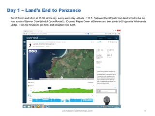
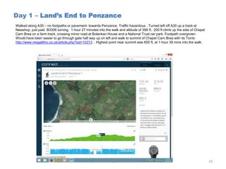
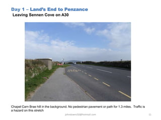
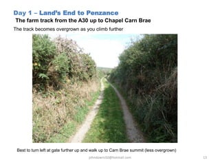
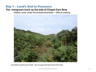
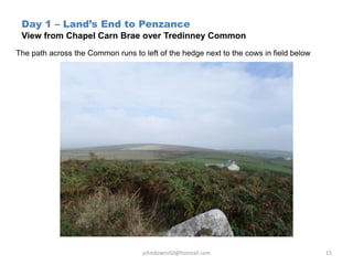
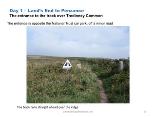
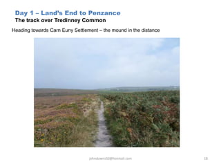
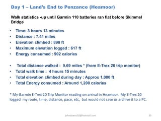
A Ramble through Cornwall - Day 1 - Lands End to Penzance John Downs
Describes the first day of a 10-day walk through Cornwall from Lands End to Launceston in easy 9-mile stages on minor roads and footpaths. This walk on Day 1 was from Lands End to Penzance.
The Cranbrook Access Options to new Rails TrailsTrails BC
This photo album report high lights the access options that are required to intergrate the new Cranbrook to Kimberley Rails to the existing trail infrastructure in Cranbrook. This would allow community recreationalists a safe and green access from the popular Rotary Way to the new pathway.
Gray Creek to Kimberley Trans Canada Trail PhotoAlbum PresentationTrails BC
This 2005 and revised in 2008 Trails BC photo album/PowerPoint Presentation looks at the potential of a Trans Canada Trail routing option between Gray Creek and Kimberley BC
Cranbrook to Baynes Lake, BC TCT Route ProposalTrails BC
This 2005 PPT/Photo Album outlines the rational that Trails BC used in rerouting the proposed TCT route between Cranbrook and Baynes Lake from the east side of the Kootenay River to the West Side.
A Walk through Devon - Day 4 - Stockley Hamlet (Okehampton) to Bondleigh BridgeJohn Downs
Day 4 of an 8-day walk through Devon. An 8-mile walk from Stockley Hamlet to Bondleigh Bridge on a route that could be used by Lands End to John O'Groats long distance walkers passing through the county
Presentation to Melbourne Emergence Meetup using same structure as introductory interlude for video of Cumberland River Cabaret in preparation. This version has removed animations from that presented. Three slides are placeholders for short videos and two for scrolling Facebook threads.
A Ramble through Cornwall - Day 5 - Truro to St Stephen John Downs
A description of Day 5 of a 10-day walk through Cornwall from Lands End to Launceston in easy 9-mile stages along minor roads and footpaths. The walk on Day 5 was from Truro to St Stephen
Day 1 of a walk through Devon - From Launceston on the Cornwall /Devon border to Lewdown in Devon. The entire set of " A Walk through ..." walks currently covering the south-west of England from Lands End up into the Cotswolds could be used as a guide by Lands End-John O'Groats (LEJOG) walkers
A Ramble through Cornwall - Day 3 - Townshend to Four Lanes John Downs
A description of Day 3 of a 10-day walk through Cornwall from Lands End to Launceston in easy 9 mile stages along minor roads and footpaths. The walk on Day 3 was from Townshend to Four Lanes
In attending this course, participants will gain knowledge and develops skills relating to HPHT Well Engineering. The course focuses on key characteristics and challenges of HPHT wells from well design, planning, engineering and operational perspectives. It covers a range of topics including:
• Well Design - Casing and drillstring design, well barriers, thermal effects, drilling fluid and cement selection
• Operational Planning - Rig selection, BOP equipment issues, rig team training
• Well Delivery – fingerprinting, well bore breathing, high-reliability drilling practices, well control and well abandonment
Presentation describes the effects of phosphate brine on the gas permeability of a sandstone core. The results show that phosphate brine reduced gas permeability by more than 90%
The Course also covers both successful and unsuccessful Case Histories in HPHT drilling operations from around the globe as reported by Operators & Drilling Contractors. New technologies available to the Industry are also covered.
A Ramble through Cornwall - Day 2 - Penzance to Townshend John Downs
A description of Day 2 of a 10-day walk through Cornwall from Lands End to Launceston in easy 9 mile stages along minor roads and footpaths. The walk on Day 2 was from Penzance to Townshend.
A Ramble through Cornwall - Day 8 - Bodmin to St Neot John Downs
A short (7 mile) walk from the outskirts of Bodmin east to St Neot, skirting the southern border of Bodmin Moor. Mostly walking in fog on this particular day
A Walk Through Devon - Day 6 - Morchard Bishop to Five Crosses John Downs
Day 6 of an 8-day walk through Devon. An 8-mile walk from Morchard Bishop to Five Crosses on a route that could be used by Lands End to John O'Groats long distance walkers passing through the county
A Ramble through Cornwall - Day 4 – Four Lanes to TruroJohn Downs
A description of Day 4 of a 10-day walk through Cornwall from Lands End to Launceston in easy 9 mile stages along minor roads and footpaths. The walk on Day 4 was from Four Lanes to Truro - and I took a wrong turning, so it became an 11 mile walk
A walk from Land's End to Launceston, in easy 8- to 9- mile stages, on minor roads and footpaths. The walk on Day 7 was from Victoria Services to Cardinham Woods outside of Bodmin
A Ramble Through Cornwall - Day 6 - St Stephen to Victoria (Bodmin) John Downs
Describes the 6th of a 10-day walk through Cornwall from Lands End to Launceston in easy 9-mile stages on minor roads and footpaths. This walk on Day 6 was from St Stephen to Victoria near Bodmin.
Day 2 of a walk through Devon - From Lewdown to Bridestowe. The entire set of " A Walk through ..." walks currently covering the south-west of England from Lands End up into the Cotswolds could be used as a route guide by Lands End-John O'Groats (LEJOG) walkers
Similar to A walk from Land's End to Penzance in Cornwall (8)
Assessing the Influence of Transportation on the Tourism Industry in Nigeriagsochially
This research dissertation investigates the complex interplay between transportation and the tourism industry in Nigeria, aiming to unravel critical insights that contribute to the enhancement of the overall tourist experience. The study employs a multi-faceted approach, literature review establishes a robust theoretical framework, incorporating The Service Quality and Satisfaction Theory to guide the research questions and hypotheses.
The methodology involves the distribution of a structured questionnaire, ensuring a representative sample and facilitating a comprehensive analysis of the gathered data.
Key findings include the nuanced perceptions of transportation infrastructure adequacy, safety and security concerns, financial influences on travel decisions, and the cultural and ecological impacts of transportation choices. These findings culminate in a comprehensive set of recommendations for policymakers and practitioners in the Nigerian tourism industry. The findings contribute to the existing literature by providing actionable insights for policymakers, stakeholders, and researchers in the Nigerian tourism sector.
The recommendations encompass gender-sensitive planning, infrastructure enhancements, safety measures, and strategic interventions to address financial constraints, ensuring a holistic and sustainable development of the tourism industry in Nigeria.
Author: Imafidon Osademwingie Martins
The Power of a Glamping Go-To-Market Accelerator Plan.pptxRezStream
Unlock the secrets to success with our comprehensive 8-Step Glamping Accelerator Go-To-Market Plan! Watch our FREE webinar, where you'll receive expert guidance and invaluable insights on every aspect of launching and growing your glamping business.
How To Talk To a Live Person at American Airlinesflyn goo
This page by FlynGoo can become your ultimate guide to connecting with a live person at American Airlines. Have you ever felt lost in the automated maze of customer service menus? FlynGoo is here to rescue you from endless phone trees and automated responses. With just a click or a call to a specific number, we ensure you get the human touch you deserve. No more frustration, no more waiting on hold - we simplify the process, making your travel experience smoother and more enjoyable.
Wayanad-The-Touristry-Heaven to the tour.pptxcosmo-soil
Wayanad, nestled in Kerala's Western Ghats, is a lush paradise renowned for its scenic landscapes, rich biodiversity, and cultural heritage. From trekking Chembra Peak to exploring ancient Edakkal Caves, Wayanad offers thrilling adventures and serene experiences. Its vibrant economy, driven by agriculture and tourism, highlights a harmonious blend of nature, tradition, and modernity.
BTW UK Visa Application Process, Uk Visa complete guide, Uk Visa fees, requirements and application process. Know all about uk visa and best way to apply for the uk visa. Get to know about the requirements that allows you for the faster visa appliaction. BTW UK Visa Application Process, Uk Visa complete guide, Uk Visa fees, requirements and application process. Know all about uk visa and best way to apply for the uk visa. Get to know about the requirements that allows you for the faster visa appliaction. BTW UK Visa Application Process, Uk Visa complete guide, Uk Visa fees, requirements and application process. Know all about uk visa and best way to apply for the uk visa. Get to know about the requirements that allows you for the faster visa appliaction. BTW UK Visa Application Process, Uk Visa complete guide, Uk Visa fees, requirements and application process. Know all about uk visa and best way to apply for the uk visa. Get to know about the requirements that allows you for the faster visa appliaction. BTW UK Visa Application Process, Uk Visa complete guide, Uk Visa fees, requirements and application process. Know all about uk visa and best way to apply for the uk visa. Get to know about the requirements that allows you for the faster visa appliaction. BTW UK Visa Application Process, Uk Visa complete guide, Uk Visa fees, requirements and application process. Know all about uk visa and best way to apply for the uk visa. Get to know about the requirements that allows you for the faster visa appliaction. BTW UK Visa Application Process, Uk Visa complete guide, Uk Visa fees, requirements and application process. Know all about uk visa and best way to apply for the uk visa. Get to know about the requirements that allows you for the faster visa appliaction. BTW UK Visa Application Process, Uk Visa complete guide, Uk Visa fees, requirements and application process. Know all about uk visa and best way to apply for the uk visa. Get to know about the requirements that allows you for the faster visa appliaction. Get information in this PDF and simplyfy your visa process.
Hidden Gems of Europe - DISCOVERING THE CONTINENT'S BEST-KEPT SECRETSKamil Uğraş TÜRKOĞLU
Europe, continent rich in history, culture, and natural beauty, is often synonymous with famous cities like Paris, Rome, and London. These iconic destinations attract millions of tourists every year, captivating them with their renowned landmarks, vibrant culture, and bustling urban life. However, beyond these well-trodden paths lie countless hidden gems waiting to be discovered. These lesser-known destinations offer unique experiences, authentic encounters, and breathtaking landscapes that often surpass the allure of their famous counterparts.
In "Hidden Gems of Europe," we embark on a journey to uncover these secret spots, exploring the heart and soul of Europe through its quaint villages, charming towns, and secluded natural wonders. This book aims to inspire travelers to look beyond the obvious and venture into the lesser-explored corners of the continent, where true adventure and discovery await.
Hidden Gems of Europe - DISCOVERING THE CONTINENT'S BEST-KEPT SECRETS
A walk from Land's End to Penzance in Cornwall
1. A CORNISH RAMBLE
Land’s End to Roche
20-25th September 2014
Day 1 – Land’s End to Penzance – 9.69 miles
OS Explorer Map 102
johndowns50@hotmail.com 1
John Downs
2. Day 1 – Land’s End to Penzance
Route* tracked by my Garmin 110 on 20th September 2014
* My Garmin’s batteries went flat around 3 miles before reaching Penzance
johndowns50@hotmail.com 2
3. Day 1 – Land’s End to Penzance
Full distance walked was 9.69 miles (measured by Garmin E-Trex 20)
johndowns50@hotmail.com 3
4. Set off from Land’s End at 11.30. A fine dry, sunny warm day. Altitude : 113 ft. Followed the cliff path from Land’s End to the top
road south of Sennen Cove (start of Cycle Route 3). Crossed Mayon Green at Sennen and then joined A30 opposite Whitesands
Lodge. Took 56 minutes to get here, and elevation now 330ft.
Day 1 – Land’s End to Penzance
johndowns50@hotmail.com 4
5. Day 1 – Land’s End to Penzance
View from Land’s End towards Sennen
johndowns50@hotmail.com 5
6. Day 1 – Land’s End to Penzance
Coastal cliff path to Sennen Cove
johndowns50@hotmail.com 6
7. DAY 1 – Land’s End to Penzance
Coastal cliff path coming into Sennen
johndowns50@hotmail.com 7
8. Day 1 – Land’s End to Penzance
Route into Sennen after leaving coastal path
johndowns50@hotmail.com 8
9. Day 1 – Land’s End to Penzance
View down to Sennen Cove beach
johndowns50@hotmail.com 9
10. Day 1 – Land’s End to Penzance
Walked along A30 – no footpaths or pavement- towards Penzance. Traffic hazardous . Turned left off A30 up a track at
Newshop, just past B3306 turning. 1 hour 27 minutes into the walk and altitude of 399 ft. 200 ft climb up the side of Chapel
Carn Brea on a farm track, crossing minor road at Bolankan House and a National Trust car park. Footpath overgrown.
Would have been easier to go through gate half way up on left and walk to summit of Chapel Carn Brea with its Tomb:
http://www.megalithic.co.uk/article.php?sid=10213 . Highest point near summit was 600 ft, at 1 hour 39 mins into the walk.
johndowns50@hotmail.com 10
11. Day 1 – Land’s End to Penzance
Leaving Sennen Cove on A30
Chapel Carn Brae hill in the background. No pedestrian pavement or path for 1.3 miles. Traffic is
a hazard on this stretch
johndowns50@hotmail.com 11
12. Day 1 – Land’s End to Penzance
On the A30 heading towards Chapel Carn Brae
A lot of jumping into the hedgerows/banks to avoid traffic on busy road
johndowns50@hotmail.com 12
13. Day 1 – Land’s End to Penzance
The farm track from the A30 up to Chapel Carn Brae
The track becomes overgrown as you climb further
Best to turn left at gate further up and walk up to Carn Brae summit (less overgrown)
johndowns50@hotmail.com 13
14. Day 1 – Land’s End to Penzance
The overgrown track up the side of Chapel Carn Brae
Hidden rocks under the bracken/brambles – difficult walking
Carn Brae summit just to left – but no way over fence from this track
johndowns50@hotmail.com 14
15. Day 1 – Land’s End to Penzance
View from Chapel Carn Brae over Tredinney Common
The path across the Common runs to left of the hedge next to the cows in field below
johndowns50@hotmail.com 15
16. Day 1 – Land’s End to Penzance
Crossed minor road and then straight ahead through Tredinney Common on good open flat trackway that finishes beside St Euny’s
Chapel and Wells (both sides of track). http://www.megalithic.co.uk/article.php?sid=12325 . Nearby is Carn Euny, an Iron Age
settlement. http://en.wikipedia.org/wiki/Carn_Euny. Took a left at the Carn Euny settlement and then a right to follow trackway running
behind Caer Bran Farm. Badly overgrown with brambles, etc. Caer Bran hill fort looming on the right.
http://en.wikipedia.org/wiki/Caer_Bran. Then across open moorland to minor road running from Sancreed to St Just, at Grumbla
Common. Reached the walk’s highest point , 619 ft, on this path beside Caer Bran. Walking time : 2 hours 34 minutes.
johndowns50@hotmail.com 16
17. Day 1 – Land’s End to Penzance
The entrance to the track over Tredinney Common
The entrance is opposite the National Trust car park, off a minor road
johndowns50@hotmail.com 17
The track runs straight ahead over the ridge
18. Day 1 – Land’s End to Penzance
The track over Tredinney Common
Heading towards Carn Euny Settlement – the mound in the distance
johndowns50@hotmail.com 18
19. Day 1 – Land’s End to Penzance
The track behind Caer Bran farm
Caer Bran hill fort is on the right behind high hedge
johndowns50@hotmail.com 19
20. Day 1 – Land’s End to Penzance
The route around the foot of Caer Bran hill fort
The line of the track is marked by some small trees in front of the farm buildings
johndowns50@hotmail.com 20
Aerial photo by Hamish Fenton - http://www.megalithic.co.uk/article.php?sid=19351
21. Day 1 – Land’s End to Penzance
The last part of the track across Caer Bran
Grumbla Common and The Beacon ahead
johndowns50@hotmail.com 21
22. Day 1 – Land’s End to Penzance
Crossed road onto Grumbla Common footpath that disappeared completely under bracken and brambles. I followed rough
animal tracks through the undergrowth almost to summit of Sancreed Beacon http://en.wikipedia.org/wiki/Sancreed_Beacon and
then down to an unnamed settlement on a minor road coming out of Sancreed. This detour is obvious on the Google Earth map
of my route. Took a left onto the road, and then a right at the T-junction. Climbed hill out of settlement past Trannack Mill and
followed this road for several miles to Skimmel Bridge and then on to Tremethick Cross on the A 30171 (Penzance to St Just
road) . The battery on my Garmin ran out half way along this long section of minor road. Crossed the A3071 and took a B-road
past West Lodge and Boscathnoe reservoir on to Heamoor village, where I stopped just before the big school.
johndowns50@hotmail.com 22
23. Day 1 – Land’s End to Penzance
The entrance to Grumbla Common
No visible footpath ahead after 50 metres. Sancreed Beacon in the distance on right
johndowns50@hotmail.com 23
24. Day 1 – Land’s End to Penzance
View across Grumbla Common
Footpath disappears off downhill to left after 50 metres. I took a right up through the
bracken
johndowns50@hotmail.com 24
25. Day 1 – Land’s End to Penzance
View back across Grumbla Common
I guess this is the terminus of the footpath that disappeared soon after entering the
Common
johndowns50@hotmail.com 25
26. Day 1 – Land’s End to Penzance
The road to Skimmel Bridge and Tremethick Cross
Taken just after Trannack Mill, at the top of the hill
johndowns50@hotmail.com 26
27. Day 1 – Land’s End to Penzance
The road between Trannack Mill and Skimmel Bridge
Skimmel Bridge about half a mile ahead down hill
johndowns50@hotmail.com 27
28. Day 1 – Land’s End to Penzance
The river at Skimmel Bridge
Now within 1 mile of Tremethick Cross
johndowns50@hotmail.com 28
29. Day 1 – Land’s End to Penzance
Tremethick Cross and the road opposite to Heamoor/Penzance
The road opposite, by the house, leads downhill to Heamoor on the
outskirts of Penzance - the destination on Day 1 !
johndowns50@hotmail.com 29
30. Day 1 – Land’s End to Penzance (Heamoor)
Walk statistics -up until Garmin 110 batteries ran flat before Skimmel
Bridge
johndowns50@hotmail.com 30
• Time: 3 hours 13 minutes
• Distance : 7.41 miles
• Elevation climbed : 890 ft
• Maximum elevation logged : 617 ft
• Energy consumed : 902 calories
• Total distance walked : 9.69 miles * (from E-Trex 20 trip monitor)
• Total walk time : 4 hours 15 minutes
• Total elevation climbed during day : Approx 1,000 ft
• Total Energy consumed : Around 1,200 calories
* My Garmin E-Trex 20 Trip Monitor reading on arrival in Heamoor. My E-Trex 20
logged my route, time, distance, pace, etc, but would not save or archive it to a PC.