SlideShare a Scribd company logo
1 of 1
((
((
((
((
((
((((((((((((((
((((((
((
((
((((((((
((
((
((
((
((
((
((
((((((((((((((((((
((
((
((
((
((
((
((
((
((
((
((
((
((
((
((
((
((((
((
((((
((
((
((
((
((
((
((
((
(( ((
((((((
((
((
(( (( (( (( (( (( (( (( (( ((
((
((
((
((((((((((((((((((
((
((
((
((
((
((
((
((
((
((((
((
((
((
((
((
((
((((((((((
((
((((((((((((((((
((
((
((
((
((((
((
((
((
((
((
((
((((
((
((
((
((((((
((((((
((
((
((
((((((((((
((
((
((((((((
((
((
((
((
((
((((((
((
((
((((((
((
((
((
((
((
((
((
((((((((((((((((((
((
((
((
((
((
((
((
((
((
((
((
((
((
((
((((((((((((((((((((((((((
((((
((
((
((
((
((
((
((((((
((
((
(( (( (( (( (( (( (( (( (( (( (( ((
((
((
((
((
((((((
((
((
((
((
((
((
((((
((
((
((
F
F
Geography of Bulls Gap, Alabama, 7.5' Quadrangle
Legend
Structure
STRUCTURE
o
AP3
Ù
F3_S
o
S0
È
S1
Ê
S1_90
TYPE
F Anticline
Contact
TYPE
Approximate Contact
Contact
(( (( (( ((
Fault Contact
Water Body
Lithology
TYPE
Dtes
S-Dtld
S-Dtldbq
S-Dtldcm
hd
hf
hfa
hfgr
hgs
pbm
pbma
pbmgr
rg
Water Body
Brian C. Averitt

More Related Content

Viewers also liked

Implementing Science Investigations for the CSEC SBA
Implementing Science Investigations for the CSEC SBAImplementing Science Investigations for the CSEC SBA
Implementing Science Investigations for the CSEC SBADebbie-Ann Hall
 
BIOLOGY SBA (LAB)
BIOLOGY SBA (LAB)BIOLOGY SBA (LAB)
BIOLOGY SBA (LAB)Cxc Sba
 
Precipitation ppt
Precipitation pptPrecipitation ppt
Precipitation pptblain9
 
River Channel Processes & Landforms
River Channel Processes & LandformsRiver Channel Processes & Landforms
River Channel Processes & LandformsMalia Damit
 
River Changes And Landforms
River Changes And LandformsRiver Changes And Landforms
River Changes And Landformswhiskeyhj
 
Precipitation presentation
Precipitation presentationPrecipitation presentation
Precipitation presentationHamza Ali
 
Erosional and depositional landforms
Erosional and depositional landformsErosional and depositional landforms
Erosional and depositional landformsMd. Saiful Islam
 
Geography AS Level full revision notes
Geography AS Level full revision notesGeography AS Level full revision notes
Geography AS Level full revision notesBrittany Farrant
 

Viewers also liked (10)

Implementing Science Investigations for the CSEC SBA
Implementing Science Investigations for the CSEC SBAImplementing Science Investigations for the CSEC SBA
Implementing Science Investigations for the CSEC SBA
 
BIOLOGY SBA (LAB)
BIOLOGY SBA (LAB)BIOLOGY SBA (LAB)
BIOLOGY SBA (LAB)
 
Precipitation ppt
Precipitation pptPrecipitation ppt
Precipitation ppt
 
River Channel Processes & Landforms
River Channel Processes & LandformsRiver Channel Processes & Landforms
River Channel Processes & Landforms
 
Rivers
RiversRivers
Rivers
 
River Changes And Landforms
River Changes And LandformsRiver Changes And Landforms
River Changes And Landforms
 
Precipitation presentation
Precipitation presentationPrecipitation presentation
Precipitation presentation
 
Erosional and depositional landforms
Erosional and depositional landformsErosional and depositional landforms
Erosional and depositional landforms
 
Geography AS Level full revision notes
Geography AS Level full revision notesGeography AS Level full revision notes
Geography AS Level full revision notes
 
2015 CSEC Regional Merit List By Subject
2015 CSEC Regional Merit List By Subject2015 CSEC Regional Merit List By Subject
2015 CSEC Regional Merit List By Subject
 

More from fabernotch

Property Line Map
Property Line MapProperty Line Map
Property Line Mapfabernotch
 
Species Count Base Map
Species Count Base MapSpecies Count Base Map
Species Count Base Mapfabernotch
 
Suitable Site Location
Suitable Site LocationSuitable Site Location
Suitable Site Locationfabernotch
 
Flooding Project
Flooding ProjectFlooding Project
Flooding Projectfabernotch
 

More from fabernotch (6)

Property Line Map
Property Line MapProperty Line Map
Property Line Map
 
Species Count Base Map
Species Count Base MapSpecies Count Base Map
Species Count Base Map
 
Suitable Site Location
Suitable Site LocationSuitable Site Location
Suitable Site Location
 
Flooding Project
Flooding ProjectFlooding Project
Flooding Project
 
Church
ChurchChurch
Church
 
Cheaha Mt
Cheaha MtCheaha Mt
Cheaha Mt
 

Bulls Gap

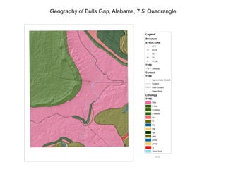
  • 1. (( (( (( (( (( (((((((((((((( (((((( (( (( (((((((( (( (( (( (( (( (( (( (((((((((((((((((( (( (( (( (( (( (( (( (( (( (( (( (( (( (( (( (( (((( (( (((( (( (( (( (( (( (( (( (( (( (( (((((( (( (( (( (( (( (( (( (( (( (( (( (( (( (( (( (((((((((((((((((( (( (( (( (( (( (( (( (( (( (((( (( (( (( (( (( (( (((((((((( (( (((((((((((((((( (( (( (( (( (((( (( (( (( (( (( (( (((( (( (( (( (((((( (((((( (( (( (( (((((((((( (( (( (((((((( (( (( (( (( (( (((((( (( (( (((((( (( (( (( (( (( (( (( (((((((((((((((((( (( (( (( (( (( (( (( (( (( (( (( (( (( (( (((((((((((((((((((((((((( (((( (( (( (( (( (( (( (((((( (( (( (( (( (( (( (( (( (( (( (( (( (( (( (( (( (( (( (((((( (( (( (( (( (( (( (((( (( (( (( F F Geography of Bulls Gap, Alabama, 7.5' Quadrangle Legend Structure STRUCTURE o AP3 Ù F3_S o S0 È S1 Ê S1_90 TYPE F Anticline Contact TYPE Approximate Contact Contact (( (( (( (( Fault Contact Water Body Lithology TYPE Dtes S-Dtld S-Dtldbq S-Dtldcm hd hf hfa hfgr hgs pbm pbma pbmgr rg Water Body Brian C. Averitt