SlideShare a Scribd company logo
1 of 28
Download to read offline
Tulsa 
District 
Albuquerque District 
Fort Worth 
District 
Galveston District 
Little Rock 
District 
Mee xx ii cc oo 
OOkkllaahhoommaa 
NNeeww MMeexxiiccoo 
Structures Overview 
Fort Worth District 
Federal Levee 
Non-Federal Levee 
Federal Channel 
Bank Protection 
USACE Lakes 
0 20 40 80 
Miles 
4/2/2014 
Geospatial Services Section 
Eli Kangas, Chief 
Jennifer Holland, Geographer
A n d e r s o n 
C o u n t y 
F r e e s t o n e 
C o u n t y 
2 
L e o n 
C o u n t y 
Non-Federal Levees 
1 
2 
3 Anderson LID 2 Trinity LB 
Henderson LID 3 Trinity LB 
N a v a r r o 
C o u n t y 
H o u s t o n 
3 
1 
Anderson LID 1 Cedar Lake LB 
RIP Status 
Fort Worth District 
Anderson County, Texas 
This product is reproduced from geospatial information 
prepared by the U.S. Army Corps of Engineers. GIS data and 
product accuracy may vary. Data may be: developed from 
sources of differing accuracy, accurate only at certain scales, 
based on modeling or interpretation, incomplete while being 
created or revised, etc. Using GIS products for purposes other 
than those for which they were created may yield inaccurate or 
misleading results. The Corps of Engineers reserves the right to 
correct, update, modify, or replace GIS products without 
notification. For more information contact the Fort Worth District 
L i m e s t o n e C o u n t y 
C o u n t y 
H o u s t o n 
C o u n t y 
L e o n 
C o u n t y 
N a v a r r o 
C o u n t y 
A n d e r s o n 
C o u n t y 
C h e r o k e e 
C o u n t y 
H e n d e r s o n 
C o u n t y 
F r e e s t o n e 
C o u n t y 
L i m e s t o n e 
C o u n t y 
S m i t h 
C o u n t y 
E l l i s 
C o u n t y 
R o b e r t s o n 
C o u n t y 
T r i n i t y 
C o u n t y 
Va n Z a n d t 
C o u n t y 
K a u f m a n 
C o u n t y 
F a l l s 
C o u n t y 
M a d i s o n 
C o u n t y 
H i l l 
C o u n t y 
W a l k e r 
C o u n t y 
0 2 4 8 
Miles 
Eligible for RIP 
Not Eligible for RIP 
4/1/2014 
Geospatial Services Section 
Eli Kangas, Chief 
Jennifer Holland, Geographer 
Geospatial Office.
A t a s c o s a 
C o u n t y 
W i l s o n 
C o u n t y 
B e x a r 
C o u n t y 
1 
2 
Federal Channels 
1 
Poteet Channel 
2 Pleasanton Flood Channel 
B e x a r 
C o u n t y 
A t a s c o s a 
C o u n t y 
W i l s o n 
C o u n t y 
M e d i n a 
C o u n t y 
F r i o 
C o u n t y 
K a r n e s 
C o u n t y 
RIP Status 
Fort Worth District 
Atascosa County, Texas 
0 0.75 1.5 3 
Miles 
Eligible for RIP 
Not Eligible for RIP 
4/1/2014 
This product is reproduced from geospatial information 
prepared by the U.S. Army Corps of Engineers. GIS data and 
product accuracy may vary. Data may be: developed from 
sources of differing accuracy, accurate only at certain scales, 
based on modeling or interpretation, incomplete while being 
created or revised, etc. Using GIS products for purposes other 
than those for which they were created may yield inaccurate or 
misleading results. The Corps of Engineers reserves the right to 
correct, update, modify, or replace GIS products without 
notification. For more information contact the Fort Worth District 
Geospatial Services Section 
Eli Kangas, Chief 
Jennifer Holland, Geographer 
Geospatial Office.
B a s t r o p 
C o u n t y 
L e e 
C o u n t y 
WWii ll ll oo ww CC rr ee ee kk 
F a y e t t e 
C o u n t y 
GG aa zz ll ee yy CC rr ee ee kk 
JJ DD CC rree ee kk 
Hunt Branch 
AAlluumm CC rr ee ee kk 
WWooll ff CC rr ee eekk 
Wolf Creek 
1 
Bank Protection 
1 Colorado River Channel 
B a s t r o p 
C o u n t y 
F a y e t t e 
C o u n t y 
RIP Status 
Fort Worth District 
Bastrop County, Texas 
0 0.3 0.6 1.2 
Miles 
Eligible for RIP 
Not Eligible for RIP 
4/1/2014 
This product is reproduced from geospatial information 
prepared by the U.S. Army Corps of Engineers. GIS data and 
product accuracy may vary. Data may be: developed from 
sources of differing accuracy, accurate only at certain scales, 
based on modeling or interpretation, incomplete while being 
created or revised, etc. Using GIS products for purposes other 
than those for which they were created may yield inaccurate or 
misleading results. The Corps of Engineers reserves the right to 
correct, update, modify, or replace GIS products without 
notification. For more information contact the Fort Worth District 
Geospatial Services Section 
Eli Kangas, Chief 
Jennifer Holland, Geographer 
Geospatial Office.
B e x a r 
C o u n t y 
SSaa nn AAnn tt oo nn ii oo RR ii vvee rr 
AA ll aa zz aa nn 
CC 
rr ee ee kk 
RIP Status 
Fort Worth District 
Bexar County, Texas 
San Pedro Creek 
1 
2 
Federal Channel 
1 San Antonio Channel 
2 San Antonio Channel 
B e x a r 
C o u n t y 
0 0.225 0.45 0.9 
Miles 
Eligible for RIP 
Not Eligible for RIP 
4/1/2014 
This product is reproduced from geospatial information 
prepared by the U.S. Army Corps of Engineers. GIS data and 
product accuracy may vary. Data may be: developed from 
sources of differing accuracy, accurate only at certain scales, 
based on modeling or interpretation, incomplete while being 
created or revised, etc. Using GIS products for purposes other 
than those for which they were created may yield inaccurate or 
misleading results. The Corps of Engineers reserves the right to 
correct, update, modify, or replace GIS products without 
notification. For more information contact the Fort Worth District 
Geospatial Services Section 
Eli Kangas, Chief 
Jennifer Holland, Geographer 
Geospatial Office.
C o o k e 
C o u n t y 
PPee cc aann CC rreeeekk 
WW hh eeee llee rr CCrr ee ee kk 
L o v e 
C o u n t y 
RR ee dd mm oo nn dd BB rr aa nn cchh 
ii vv ee rr 
EE ll mm FF oo rr kk TT rr ii nn ii tt yy RR 
Non-Federal Levee 
1 Leonard Park Elm Fork LB 
RIP Status 
Fort Worth District 
Cooke County, Texas 
This product is reproduced from geospatial information 
prepared by the U.S. Army Corps of Engineers. GIS data and 
product accuracy may vary. Data may be: developed from 
sources of differing accuracy, accurate only at certain scales, 
based on modeling or interpretation, incomplete while being 
created or revised, etc. Using GIS products for purposes other 
than those for which they were created may yield inaccurate or 
misleading results. The Corps of Engineers reserves the right to 
correct, update, modify, or replace GIS products without 
notification. For more information contact the Fort Worth District 
SS cc oo tt tt 
CC rr ee ee kk 
DD oo zz ii ee rr CC rr ee ee kk 
RR oo cc kk CC rree eekk 
MMoo nn tt aa gg uu ee CC rr ee ee kk 
1 
2 
Federal Channel 
2 Wheeler Creek Channel 
C o o k e 
C o u n t y 
0 0.3 0.6 1.2 
Miles 
Eligible for RIP 
Not Eligible for RIP 
4/1/2014 
Geospatial Services Section 
Eli Kangas, Chief 
Jennifer Holland, Geographer 
Geospatial Office.
D a l l a s 
C o u n t y 
Federal Levee 
1 Bois D’Arc Levee Trinity LB 
2 Central WWTP Trinity RB 
3 East Dallas Levee Trinity LB 
4 Irving Levee (IFCD-1 East) 
5 Irving Levee (IFCD-1 West) 
6 Rochester Levee Trinity LB 
7 West Dallas Levee Trinity RB 
9 Dallas LID 14 Trinity RB 
10 Dallas LID 2 Trinity RB 
11 Kaufman LID 15 East Fork Trinity LB 
12 Kaufman LID 6 East Fork Trinity RB 
13 Kaufman LID 8 East Fork Trinity RB 
14 Dallas Floodway Channel 
15 Delaware Creek Channel 
16 Dry Branch Channel 
17 Duck Creek Channel 
18 Hutton Branch Channel 
19 Ten Mile Creek Channel 
T a r r a n t 
C o u n t y 
F a n n i n 
C o u n t y 
R o c k w a l l 
C o u n t y 
K a u f m a n 
C o u n t y 
E l l i s 
C o u n t y 
C o l l i n 
C o u n t y 
D e n t o n 
C o u n t y 
4/1/2014 
Fort Worth District 
This product is reproduced from geospatial information 
prepared by the U.S. Army Corps of Engineers. GIS data and 
product accuracy may vary. Data may be: developed from 
sources of differing accuracy, accurate only at certain scales, 
based on modeling or interpretation, incomplete while being 
created or revised, etc. Using GIS products for purposes other 
than those for which they were created may yield inaccurate or 
misleading results. The Corps of Engineers reserves the right to 
correct, update, modify, or replace GIS products without 
notification. For more information contact the Fort Worth District 
J o h n s o n 
C o u n t y 
5 
D e n t o n 
C o u n t y 
W i s e 
C o u n t y 
16 12 
14 
13 
7 
8 
3 
17 
11 
9 
10 
18 
1 
2 
4 
15 
22 
20 
19 
21 
6 
Non-Federal Levee 
8 Dallas LID 1 Trinity RB 
Federal Channel 
Bank Protection 
20 Cottonwook Creek Bank Protection 
21 Grand Prairie Sanitary Landfill 
Bank Protection 
22 Bank Protection, Meyers Rd 
D a l l a s 
C o u n t y 
E l l i s 
C o u n t y 
Ta r r a n t 
C o u n t y 
C o l l i n 
C o u n t y 
H u n t 
C o u n t y 
K a u f m a n 
C o u n t y 
J o h n s o n 
C o u n t y 
N a v a r r o 
C o u n t y 
H i l l 
C o u n t y 
R o c k w a l l 
C o u n t y 
RIP Status 
Dallas County, Texas 
0 1.75 3.5 7 
Miles 
Eligible for RIP 
Not Eligible for RIP 
Geospatial Services Section 
Eli Kangas, Chief 
Jennifer Holland, Geographer 
Geospatial Office.
Non-Federal Levee 
1 Lamar LID 1 North Sulphur RB 
RIP Status 
Fort Worth District 
C o o p e r D a m / J i m C h a p m a n L a k e 
H o p k i n s 
C o u n t y 
D e l t a 
C o u n t y 
L a m a r 
C o u n t y 
R e d R i v e r 
C o u n t y 
F r a n k l i n 
C o u n t y 
4 
3 
1 
2 
2 Franklin LID 1 Sulphur RB 
3 Delta LID 1 South Sulphur RB 
4 Delta LID 1 South Sulphur LB 
L a m a r 
C o u n t y 
H o p k i n s 
C o u n t y 
R e d R i v e r 
C o u n t y 
F a n n i n 
C o u n t y 
H u n t 
C o u n t y 
D e l t a 
C o u n t y 
T i t u s 
C o u n t y 
C a m p 
C o u n t y 
F r a n k l i n 
C o u n t y 
Wo o d 
C o u n t y 
R a i n s 
C o u n t y 
M c C u r t a i n 
C o u n t y 
Delta County, Texas 
0 1.25 2.5 5 
Miles 
Eligible for RIP 
Not Eligible for RIP 
4/1/2014 
This product is reproduced from geospatial information 
prepared by the U.S. Army Corps of Engineers. GIS data and 
product accuracy may vary. Data may be: developed from 
sources of differing accuracy, accurate only at certain scales, 
based on modeling or interpretation, incomplete while being 
created or revised, etc. Using GIS products for purposes other 
than those for which they were created may yield inaccurate or 
misleading results. The Corps of Engineers reserves the right to 
correct, update, modify, or replace GIS products without 
notification. For more information contact the Fort Worth District 
Geospatial Services Section 
Eli Kangas, Chief 
Jennifer Holland, Geographer 
Geospatial Office.
D e n t o n 
C o u n t y 
D a l l a s 
C o u n t y 
FF uu rr nn ee aa uu xx CC rr ee ee kk 
II nndd iiaa nn CCrree ee kk 
Bank Protection 
Dudley Branch 
Furneaux Creek 
1 
1 McCoy Rd Bank Protection 
D e n t o n 
C o u n t y 
D a l l a s 
C o u n t y 
RIP Status 
Fort Worth District 
Denton County, Texas 
0 0.125 0.25 0.5 
Miles 
Eligible for RIP 
Not Eligible for RIP 
4/1/2014 
This product is reproduced from geospatial information 
prepared by the U.S. Army Corps of Engineers. GIS data and 
product accuracy may vary. Data may be: developed from 
sources of differing accuracy, accurate only at certain scales, 
based on modeling or interpretation, incomplete while being 
created or revised, etc. Using GIS products for purposes other 
than those for which they were created may yield inaccurate or 
misleading results. The Corps of Engineers reserves the right to 
correct, update, modify, or replace GIS products without 
notification. For more information contact the Fort Worth District 
Geospatial Services Section 
Eli Kangas, Chief 
Jennifer Holland, Geographer 
Geospatial Office.
B a r d w e l l L a k e 
Non-Federal Levees 
J o e P o o l L a k e 
E l l i s 
C o u n t y 
Ta r r a n t 
C o u n t y 
J o h n s o n 
C o u n t y 
N a v a r r o 
C o u n t y 
D a l l a s 
C o u n t y 
E l l i s 
C o u n t y 
K a u f m a n 
C o u n t y 
D a l l a s 
C o u n t y 
1 Navarro LID 1 Chambers LB 
2 Ellis LID 3 Trinity RB 
3 Ellis LID 2 Trinity RB 
4 Ellis LID 1 Chambers LB 
5 Ellis LID 6 Onion LB 
6 Ellis LID 4 Waxahachie RB 
7 Ellis LID 10 Trinity RB 
Fort Worth District 
This product is reproduced from geospatial information 
prepared by the U.S. Army Corps of Engineers. GIS data and 
product accuracy may vary. Data may be: developed from 
sources of differing accuracy, accurate only at certain scales, 
based on modeling or interpretation, incomplete while being 
created or revised, etc. Using GIS products for purposes other 
than those for which they were created may yield inaccurate or 
misleading results. The Corps of Engineers reserves the right to 
H i l l 
C o u n t y 
H u n t 
C o u n t y 
R o c k w a l l 
C o u n t y 
K a u f m a n 
C o u n t y 
H e n d e r s o n 
C o u n t y 
H e n d e r s o n 
C o u n t y 
5 
4 
5 
3 
6 
7 
1 
2 
RIP Status 
Ellis County, Texas 
0 1.75 3.5 7 
Miles 
Eligible for RIP 
Not Eligible for RIP 
4/1/2014 
correct, update, modify, or replace GIS products without 
notification. For more information contact the Fort Worth District 
Geospatial Services Section 
Eli Kangas, Chief 
Jennifer Holland, Geographer 
Geospatial Office. 
N a v a r r o 
H i l l C o u n t y 
C o u n t y 
F r e e s t o n e 
C o u n t y 
B o s q u e 
C o u n t y L i m e s t o n e 
C o u n t y 
A n d e r s o n 
C o u n t y
R e d R i v e r 
C o u n t y 
F r a n k l i n 
C o u n t y 
Non-Federal Levees 
1 Franklin LID 1 Sulphur RB 
L a m a r 
C o u n t y 
D e l t a 
C o u n t y 
tt hh SS uull pphh uu rr RR ii vv ee rr 
uu 
RIP Status 
Fort Worth District 
Franklin County, Texas 
H o p k i n s 
C o u n t y 
Sulphur River 
eeee kk 
CC oo bbbb JJ oo nn eess CC rr 
MM uu ss tt aann gg CC rr ee eekk 
SSoo 
1 
1 
0 0.3 0.6 1.2 
Miles 
Eligible for RIP 
Not Eligible for RIP 
4/1/2014 
This product is reproduced from geospatial information 
prepared by the U.S. Army Corps of Engineers. GIS data and 
product accuracy may vary. Data may be: developed from 
sources of differing accuracy, accurate only at certain scales, 
based on modeling or interpretation, incomplete while being 
created or revised, etc. Using GIS products for purposes other 
than those for which they were created may yield inaccurate or 
misleading results. The Corps of Engineers reserves the right to 
correct, update, modify, or replace GIS products without 
notification. For more information contact the Fort Worth District 
Geospatial Services Section 
Eli Kangas, Chief 
Jennifer Holland, Geographer 
Geospatial Office. 
R e d R i v e r 
C o u n t y 
F r a n k l i n 
C o u n t y 
L a m a r 
C o u n t y 
D e l t a 
C o u n t y 
H o p k i n s 
C o u n t y
G u a d a l u p e 
C o u n t y 
Federal Channel 
C o m a l 
C o u n t y 
1 Walnut Branch Channel 
4/1/2014 
Fort Worth District 
This product is reproduced from geospatial information 
prepared by the U.S. Army Corps of Engineers. GIS data and 
product accuracy may vary. Data may be: developed from 
sources of differing accuracy, accurate only at certain scales, 
based on modeling or interpretation, incomplete while being 
created or revised, etc. Using GIS products for purposes other 
than those for which they were created may yield inaccurate or 
misleading results. The Corps of Engineers reserves the right to 
correct, update, modify, or replace GIS products without 
notification. For more information contact the Fort Worth District 
B e x a r 
C o u n t y 
1 
RIP Status 
Guadalupe County, Texas 
0 0.75 1.5 3 
Miles 
Eligible for RIP 
Not Eligible for RIP 
Geospatial Services Section 
Eli Kangas, Chief 
Jennifer Holland, Geographer 
Geospatial Office. 
H a y s 
C o u n t y 
G u a d a l u p e 
C o u n t y 
C o m a l 
C o u n t y 
B e x a r 
C o u n t y 
C a l d w e l l 
C o u n t y 
G o n z a l e s 
C o u n t y 
W i l s o n 
C o u n t y
N a v a r r o 
C o u n t y 
H i l l 
C o u n t y 
H e n d e r s o n 
C o u n t y 
Non-Federal Levees 
1 Henderson LID 1 Trinity LB 
2 Henderson LID 3 Trinity LB 
E l l i s 
C o u n t y 
K a u f m a n 
C o u n t y 
V a n Z a n d t 
C o u n t y 
A n d e r s o n 
C o u n t y 
F r e e s t o n e 
C o u n t y 
1 
2 
RIP Status 
Fort Worth District 
Henderson County, Texas 
0 1.5 3 6 
Miles 
Eligible for RIP 
Not Eligible for RIP 
4/1/2014 
This product is reproduced from geospatial information 
prepared by the U.S. Army Corps of Engineers. GIS data and 
product accuracy may vary. Data may be: developed from 
sources of differing accuracy, accurate only at certain scales, 
based on modeling or interpretation, incomplete while being 
created or revised, etc. Using GIS products for purposes other 
than those for which they were created may yield inaccurate or 
misleading results. The Corps of Engineers reserves the right to 
correct, update, modify, or replace GIS products without 
notification. For more information contact the Fort Worth District 
Geospatial Services Section 
Eli Kangas, Chief 
Jennifer Holland, Geographer 
Geospatial Office. 
N a v a r r o 
C o u n t y 
E l l i s 
C o u n t y 
H e n d e r s o n 
C o u n t y 
K a u f m a n 
C o u n t y 
Va n Z a n d t 
C o u n t y 
F r e e s t o n e 
C o u n t y 
A n d e r s o n 
C o u n t y 
D a l l a s 
C o u n t y 
L i m e s t o n e 
C o u n t y
Non-Federal Levees 
1 Hopkins LID 1 South Sulphur RB 
CCaann nn oonn CCrr eeee kk 
C o o p e r D a m / J i m C h a p m a n L a k e 
D e l t a 
C o u n t y 
H o p k i n s 
C o u n t y 
SS oo uu tt hh SS uu ll pp hh uu rr RR ii vv ee rr 
BB ii gg CC rr eeee kk 
BBrr uu ss hh yy CC rr eeeekk 
MM oo rr ggaann CCrreeee kk 
VVaa ddeenn CCrr eeeekk 
CCrr oo ss ss tt iimm bb ee rr CC rr ee ee kk 
BB oo yy dd BB rr aann cc hh 
WWoo ll ff CCrr ee ee kk 
DD oo cc tt oorr ss CC rr ee ee kk 
EEvvaa nn ss BB 
rr aanncc hh 
LLaa kk ee 
CC rr ee eekk 
oo gg ss tt oo nn BB rr aa nn cchh 
LL 
LL ii tt tt ll ee CC aa nn ee yy CC rr ee 
ee kk 
WW oo ll ffpp ee nn CC rr eeee kk 
MMoooorree CC rr eeee kk 
MM cc GG uu yy ee rr BB rr aa nncchh 
GGrree eennbbrr ii eerr BB rr aa nn cchh 
NN oo rr tt hh CC aannee yy CC rr ee ee kk 
RR ee dd BB rr aa nn cc hh 
PP oo ss tt OOaakk CCrree ee kk 
EE aa ss tt FF oo rr kk BBiigg CCrree ee kk 
FF ii nn ll ee yy BBrr aa nn cc hh 
SS oo uu tt hh SS uu ll pp hh uu rr RR ii vv ee rr 
1 
2 
RIP Status 
Fort Worth District 
Hopkins County, Texas 
0 0.5 1 2 
Miles 
Eligible for RIP 
Not Eligible for RIP 
4/1/2014 
This product is reproduced from geospatial information 
prepared by the U.S. Army Corps of Engineers. GIS data and 
product accuracy may vary. Data may be: developed from 
sources of differing accuracy, accurate only at certain scales, 
based on modeling or interpretation, incomplete while being 
created or revised, etc. Using GIS products for purposes other 
than those for which they were created may yield inaccurate or 
misleading results. The Corps of Engineers reserves the right to 
correct, update, modify, or replace GIS products without 
notification. For more information contact the Fort Worth District 
Geospatial Services Section 
Eli Kangas, Chief 
Jennifer Holland, Geographer 
Geospatial Office. 
D e l t a 
C o u n t y 
H o p k i n s 
C o u n t y 
L a m a r 
C o u n t y
N a v a r r o 
C o u n t y 
L i m e s t o n e 
C o u n t y 
H o u s t o n 
C o u n t y 
L e o n 
C o u n t y 
M a d i s o n 
C o u n t y 
R u s k 
C o u n t y 
A n g e l i n a 
C o u n t y 
T r i n i t y 
C o u n t y 
Non-Federal Levees 
F r e e s t o n e 
C o u n t y 
A n d e r s o n 
C o u n t y 
W a l k e r 
C o u n t y 
3 
1 
2 
1 Anderson LID 2 Trinity LB 
2 Houston LID 2 Trinity LB 
3 Houston LID 1 Trinity LB 
RIP Status 
Fort Worth District 
Houston County, Texas 
0 2 4 8 
Miles 
Eligible for RIP 
Not Eligible for RIP 
4/1/2014 
This product is reproduced from geospatial information 
prepared by the U.S. Army Corps of Engineers. GIS data and 
product accuracy may vary. Data may be: developed from 
sources of differing accuracy, accurate only at certain scales, 
based on modeling or interpretation, incomplete while being 
created or revised, etc. Using GIS products for purposes other 
than those for which they were created may yield inaccurate or 
misleading results. The Corps of Engineers reserves the right to 
correct, update, modify, or replace GIS products without 
notification. For more information contact the Fort Worth District 
Geospatial Services Section 
Eli Kangas, Chief 
Jennifer Holland, Geographer 
Geospatial Office. 
H o u s t o n 
C o u n t y 
L e o n 
C o u n t y 
A n d e r s o n 
C o u n t y 
T r i n i t y 
C o u n t y 
F r e e s t o n e 
C o u n t y 
C h e r o k e e 
C o u n t y 
W a l k e r 
C o u n t y 
M a d i s o n 
C o u n t y 
P o l k 
C o u n t y 
B r a z o s 
C o u n t y 
G r i m e s 
C o u n t y 
R o b e r t s o n 
C o u n t y 
S a n J a c i n t o 
C o u n t y
H o w a r d 
C o u n t y 
Federal Channel 
1 Beals Creek Channel 
M a r t i n 
C o u n t y 1 
RIP Status 
Fort Worth District 
Howard County, Texas 
0 1 2 4 
Miles 
Eligible for RIP 
Not Eligible for RIP 
4/1/2014 
This product is reproduced from geospatial information 
prepared by the U.S. Army Corps of Engineers. GIS data and 
product accuracy may vary. Data may be: developed from 
sources of differing accuracy, accurate only at certain scales, 
based on modeling or interpretation, incomplete while being 
created or revised, etc. Using GIS products for purposes other 
than those for which they were created may yield inaccurate or 
misleading results. The Corps of Engineers reserves the right to 
correct, update, modify, or replace GIS products without 
notification. For more information contact the Fort Worth District 
Geospatial Services Section 
Eli Kangas, Chief 
Jennifer Holland, Geographer 
Geospatial Office. 
H o w a r d 
C o u n t y 
D a w s o n 
C o u n t y 
M a r t i n 
C o u n t y 
G l a s s c o c k 
C o u n t y 
M i t c h e l l 
C o u n t y 
B o r d e n 
C o u n t y 
S t e r l i n g 
C o u n t y 
M i d l a n d 
C o u n t y 
S c u r r y 
C o u n t y
H u n t 
C o u n t y 
Federal Channel 
1 Long Branch Creek Channel 
C o l l i n 
C o u n t y 
1 
RIP Status 
Fort Worth District 
Hunt County, Texas 
0 1 2 4 
Miles 
Eligible for RIP 
Not Eligible for RIP 
4/1/2014 
This product is reproduced from geospatial information 
prepared by the U.S. Army Corps of Engineers. GIS data and 
product accuracy may vary. Data may be: developed from 
sources of differing accuracy, accurate only at certain scales, 
based on modeling or interpretation, incomplete while being 
created or revised, etc. Using GIS products for purposes other 
than those for which they were created may yield inaccurate or 
misleading results. The Corps of Engineers reserves the right to 
correct, update, modify, or replace GIS products without 
notification. For more information contact the Fort Worth District 
Geospatial Services Section 
Eli Kangas, Chief 
Jennifer Holland, Geographer 
Geospatial Office. 
H u n t 
C o u n t y 
C o l l i n 
C o u n t y 
F a n n i n 
C o u n t y 
D e l t a 
C o u n t y 
H o p k i n s 
C o u n t y 
R a i n s 
C o u n t y 
R o c k w a l l 
C o u n t y 
K a u f m a n 
C o u n t y 
G r a y s o n 
C o u n t y 
Va n Z a n d t 
C o u n t y 
L a m a r 
C o u n t y
B a r d w e l l L a k e 
K a u f m a n 
C o u n t y 
D a l l a s 
C o u n t y 
E l l i s 
C o u n t y 
D a l l a s 
C o u n t y 
H e n d e r s o n 
C o u n t y 
R o c k w a l l 
C o u n t y 
N a v a r r o 
C o u n t y 
8 
3 
5 
4 
6 
7 
2 1 
Federal Channel 
11 East Fork Floodway Channel 
RIP Status 
Fort Worth District 
Kaufman County, Texas 
0 1.75 3.5 7 
Miles 
Eligible for RIP 
Not Eligible for RIP 
4/1/2014 
This product is reproduced from geospatial information 
prepared by the U.S. Army Corps of Engineers. GIS data and 
product accuracy may vary. Data may be: developed from 
sources of differing accuracy, accurate only at certain scales, 
based on modeling or interpretation, incomplete while being 
created or revised, etc. Using GIS products for purposes other 
than those for which they were created may yield inaccurate or 
misleading results. The Corps of Engineers reserves the right to 
correct, update, modify, or replace GIS products without 
notification. For more information contact the Fort Worth District 
Geospatial Services Section 
Eli Kangas, Chief 
Jennifer Holland, Geographer 
Geospatial Office. 
E l l i s 
C o u n t y 
K a u f m a n 
C o u n t y 
N a v a r r o 
C o u n t y 
H u n t 
C o u n t y 
Ta r r a n t 
C o u n t y 
H i l l 
C o u n t y 
C o l l i n 
C o u n t y 
Va n Z a n d t 
C o u n t y 
H e n d e r s o n 
C o u n t y 
D e n t o n 
C o u n t y 
J o h n s o n 
C o u n t y 
R a i n s 
C o u n t y 
R o c k w a l l 
C o u n t y 
H o p k i n s 
C o u n t y 
A n d e r s o n 
C o u n t y 
Federal Levee 
1 Kaufman 5 East, East Fork Trinity LB 
2 Kaufman 5 West, East Fork Trinity RB 
3 Kaufman MUD 1, East Fork Trinity LB 
Non-Federal Levee 
4 Bois D’Arc Levee Trinity LB 
5 Kaufman LID 1 East Fork Trinity LB 
6 Kaufman LID 10 East Fork Trinity RB 
7 Kaufman LID 13 East Fork Trinity LB 
8 Kaufman LID 15 East Fork Trinity LB 
9 Kaufman LID 6 East Fork Trinity LB 
10 Kaufman LID 8 East Fork Trinity RB 
9 
10 
11
K n o x 
C o u n t y 
H a s k e l l 
C o u n t y 
B a y l o r 
C o u n t y 
T h r o c k m o r t o n 
C o u n t y 
1 
Federal Channel 
1 Munday Channel 
RIP Status 
Fort Worth District 
Knox County, Texas 
Eligible for RIP 
Not Eligible for RIP 
0 0.75 1.5 3 
Miles 
4/1/2014 
This product is reproduced from geospatial information 
prepared by the U.S. Army Corps of Engineers. GIS data and 
product accuracy may vary. Data may be: developed from 
sources of differing accuracy, accurate only at certain scales, 
based on modeling or interpretation, incomplete while being 
created or revised, etc. Using GIS products for purposes other 
than those for which they were created may yield inaccurate or 
misleading results. The Corps of Engineers reserves the right to 
correct, update, modify, or replace GIS products without 
notification. For more information contact the Fort Worth District 
Geospatial Services Section 
Eli Kangas, Chief 
Jennifer Holland, Geographer 
Geospatial Office. 
K n o x 
C o u n t y 
H a s k e l l 
C o u n t y 
B a y l o r 
C o u n t y 
T h r o c k m o r t o n 
C o u n t y 
K i n g 
C o u n t y 
S t o n e w a l l 
C o u n t y 
F o a r d 
C o u n t y
Non-Federal Levee 
1 Lamar LID 1 North Sulphur RB 
RIP Status 
Fort Worth District 
Lamar County, Texas 
This product is reproduced from geospatial information 
prepared by the U.S. Army Corps of Engineers. GIS data and 
product accuracy may vary. Data may be: developed from 
sources of differing accuracy, accurate only at certain scales, 
based on modeling or interpretation, incomplete while being 
created or revised, etc. Using GIS products for purposes other 
than those for which they were created may yield inaccurate or 
misleading results. The Corps of Engineers reserves the right to 
C o o p e r D a m / J i m C h a p m a n L a k e 
L a m a r 
C o u n t y 
H o p k i n s 
C o u n t y 
D e l t a 
C o u n t y 
R e d R i v e r 
C o u n t y 
F r a n k l i n 
C o u n t y 
1 
0 1 2 4 
Miles 
Eligible for RIP 
Not Eligible for RIP 
4/1/2014 
correct, update, modify, or replace GIS products without 
notification. For more information contact the Fort Worth District 
Geospatial Services Section 
Eli Kangas, Chief 
Jennifer Holland, Geographer 
Geospatial Office. 
L a m a r 
C o u n t y 
H o p k i n s 
C o u n t y 
R e d R i v e r 
C o u n t y 
D e l t a 
C o u n t y 
F r a n k l i n 
C o u n t y 
T i t u s 
C o u n t y 
F a n n i n 
C o u n t y 
H u n t 
C o u n t y 
C a m p 
C o u n t y
M c L e n n a n 
C o u n t y 
Flat Creek 
CC rr ee ee kk 
SS hh aa ww 
CC oo tt tt oonn ww oo oodd CC rr ee eekk 
TT ee hhuu aa cc aa nn aa CC rr ee ee kk 
Bank Protection 
1 Brazos River Wastewater 
Treatment Plant Bank Protection 
WWaa cc ooCC rr eeeekk 
TT rr aadd ii nn gghh oo uu ss ee CC rr ee ee kk 
1 
RIP Status 
Fort Worth District 
McLennan County, Texas 
0 0.25 0.5 1 
Miles 
Eligible for RIP 
Not Eligible for RIP 
4/1/2014 
This product is reproduced from geospatial information 
prepared by the U.S. Army Corps of Engineers. GIS data and 
product accuracy may vary. Data may be: developed from 
sources of differing accuracy, accurate only at certain scales, 
based on modeling or interpretation, incomplete while being 
created or revised, etc. Using GIS products for purposes other 
than those for which they were created may yield inaccurate or 
misleading results. The Corps of Engineers reserves the right to 
correct, update, modify, or replace GIS products without 
notification. For more information contact the Fort Worth District 
Geospatial Services Section 
Eli Kangas, Chief 
Jennifer Holland, Geographer 
Geospatial Office. 
M c L e n n a n 
C o u n t y 
F a l l s 
C o u n t y
Non-Federal Levee 
1 Hefley LID Little River RB 
RIP Status 
Fort Worth District 
G r a n g e r L a k e 
M i l a m 
C o u n t y 
B e l l 
C o u n t y 
Milam County, Texas 
W i l l i a m s o n 
C o u n t y 
B u r l e s o n 
C o u n t y 
1 
0 1.25 2.5 5 
Miles 
Eligible for RIP 
Not Eligible for RIP 
4/1/2014 
This product is reproduced from geospatial information 
prepared by the U.S. Army Corps of Engineers. GIS data and 
product accuracy may vary. Data may be: developed from 
sources of differing accuracy, accurate only at certain scales, 
based on modeling or interpretation, incomplete while being 
created or revised, etc. Using GIS products for purposes other 
than those for which they were created may yield inaccurate or 
misleading results. The Corps of Engineers reserves the right to 
correct, update, modify, or replace GIS products without 
notification. For more information contact the Fort Worth District 
Geospatial Services Section 
Eli Kangas, Chief 
Jennifer Holland, Geographer 
Geospatial Office. 
M i l a m 
C o u n t y 
B e l l 
C o u n t y 
W i l l i a m s o n 
C o u n t y 
B u r l e s o n 
C o u n t y 
L e e 
C o u n t y 
R o b e r t s o n 
C o u n t y 
F a l l s 
C o u n t y 
T r a v i s 
C o u n t y B a s t r o p 
C o u n t y 
B r a z o s 
C o u n t y 
W a s h i n g t o n 
C o u n t y 
C o r y e l l 
C o u n t y
Non-Federal Levee 
1 Henderson LID 3 Trinity LB 
2 Lewis Simpson Trinity RB 
3 Navarro LID 1 Chambers LB 
4 Navarro LID 10 Chambers LB 
5 Navarro LID 10 Chambers RB 
6 Navarro LID 11 Chambers LB 
7 Navarro LID 3 Trinity RB 
8 Navarro LID 4 Chambers RB 
9 Navarro LID 6 Chambers RB 
10 Pettigrew Levee Trinity RB 
B a r d w e l l L a k e 
N a v a r r o 
C o u n t y 
H e n d e r s o n 
C o u n t y 
E l l i s 
C o u n t y 
K a u f m a n 
C o u n t y 
F r e e s t o n e 
C o u n t y 
R a i n s 
C o u n t y 
V a n Z a n d t 
C o u n t y 
A n d e r s o n 
C o u n t y 
5 
10 
3 
8 
1 
6 
7 
4 
2 
9 
RIP Status 
Fort Worth District 
Navarro County, Texas 
0 1.5 3 6 
Miles 
Eligible for RIP 
Not Eligible for RIP 
4/1/2014 
This product is reproduced from geospatial information 
prepared by the U.S. Army Corps of Engineers. GIS data and 
product accuracy may vary. Data may be: developed from 
sources of differing accuracy, accurate only at certain scales, 
based on modeling or interpretation, incomplete while being 
created or revised, etc. Using GIS products for purposes other 
than those for which they were created may yield inaccurate or 
misleading results. The Corps of Engineers reserves the right to 
correct, update, modify, or replace GIS products without 
notification. For more information contact the Fort Worth District 
Geospatial Services Section 
Eli Kangas, Chief 
Jennifer Holland, Geographer 
Geospatial Office. 
N a v a r r o 
C o u n t y 
E l l i s 
C o u n t y 
K a u f m a n 
C o u n t y 
H e n d e r s o n 
C o u n t y 
F r e e s t o n e 
C o u n t y 
Va n Z a n d t 
C o u n t y 
A n d e r s o n 
C o u n t y 
D a l l a s 
C o u n t y 
H i l l 
C o u n t y 
L i m e s t o n e 
C o u n t y L e o n 
C o u n t y
R e d R i v e r 
C o u n t y 
F r a n k l i n 
C o u n t y 
Non-Federal Levee 
1 Red River LID 1 Sulphur LB 
L a m a r 
C o u n t y 
RIP Status 
Fort Worth District 
Red River County, Texas 
D e l t a 
C o u n t y 
This product is reproduced from geospatial information 
prepared by the U.S. Army Corps of Engineers. GIS data and 
product accuracy may vary. Data may be: developed from 
sources of differing accuracy, accurate only at certain scales, 
based on modeling or interpretation, incomplete while being 
created or revised, etc. Using GIS products for purposes other 
than those for which they were created may yield inaccurate or 
misleading results. The Corps of Engineers reserves the right to 
H o p k i n s 
C o u n t y 
Sulphur River 
MM uu ss tt aa nn gg CC rr ee ee kk 
LL iitt tt ll ee SS aa nn dd yy CCrr ee ee kk 
WWhh ii tt ee OO aa kk BBrr aa nn cc hh 
SS oo uu tt hh SS uu ll pp hh uu rr RR ii vv ee rr 
tthh SS uu ll pphh uu rr RR ii vv ee rr 
uu 
SSoo 
1 
0 0.3 0.6 1.2 
Miles 
Eligible for RIP 
Not Eligible for RIP 
4/1/2014 
correct, update, modify, or replace GIS products without 
notification. For more information contact the Fort Worth District 
Geospatial Services Section 
Eli Kangas, Chief 
Jennifer Holland, Geographer 
Geospatial Office. 
R e d R i v e r 
C o u n t y 
F r a n k l i n 
C o u n t y 
L a m a r 
C o u n t y 
D e l t a 
C o u n t y 
H o p k i n s 
C o u n t y
Federal Levee 
2 Brookside Levee West Fork LB 
3 Carswell Levee West Fork LB 
4 Clear Fork Levee Loop Clear Fork LB 
5 Crestwood Levee West Fork RB 
6 North Main Levee Loop West Fork LB 
7 Overton Levee Clear Fork RB 
8 Sump #6 Levee West Fork LB 
9 Watermelon Levee Clear Fork RB 
10 West Fork Levee Loop West Fork RB 
11 White Settlement Levee West Fork RB 
23 Indian Creek Bank Protection 
RIP Status 
Fort Worth District 
Tarrant County, Texas 
This product is reproduced from geospatial information 
prepared by the U.S. Army Corps of Engineers. GIS data and 
product accuracy may vary. Data may be: developed from 
sources of differing accuracy, accurate only at certain scales, 
based on modeling or interpretation, incomplete while being 
created or revised, etc. Using GIS products for purposes other 
than those for which they were created may yield inaccurate or 
misleading results. The Corps of Engineers reserves the right to 
correct, update, modify, or replace GIS products without 
notification. For more information contact the Fort Worth District 
Federal Channel 
13 Big Fossil Floodway Channel 
14 Calloway Branch Channel 
15 Fort Worth Floodway West Fork 
Above Clear Fork Channel 
17 Fort Worth Floodway 
Clear Fork Channel 
19 Lorean Branch Channel 
20 Rush Creek Channel 
21 Singing Hills Channel 
B e n b r o o k R e s e r v o i r 
J o e P o o l L a k e 
T a r r a n t 
C o u n t y 
P a r k e r 
C o u n t y 
3 10 
5 
8 
1 
6 
7 
4 
2 
9 
1 Big Fossil Creek Levee Big Fossil LB 
Ta r r a n t 
C o u n t y 
P a r k e r 
C o u n t y 
D e n t o n 
C o u n t y 
D a l l a s 
C o u n t y 
J o h n s o n 
C o u n t y 
W i s e 
C o u n t y 
E l l i s 
C o u n t y 
H o o d 
C o u n t y 
C o l l i n 
C o u n t y 
0 1 2 4 
Miles 
Eligible for RIP 
Not Eligible for RIP 
4/1/2014 
Geospatial Services Section 
Eli Kangas, Chief 
Jennifer Holland, Geographer 
Geospatial Office. 
Non-Federal Levee 
Bank Protection 
12 Waterworks Levee Clear Fork RB 
26 Arlington Landfill Bank Protection 
27 River Oaks Bank Protection 
18 Johnson Creek Channel 
25 Park Row Bridge Bank Protection 
22 Sulphur Branch Channel 
11 
12 
13 
14 
15 
16 Fort Worth Floodway West Fork 
Below Clear Fork Channel 
16 
17 
18 
19 
20 
21 
22 
24 Marys Creek Bank Protection 
27 
26 
25 
24 
23
J o n e s 
C o u n t y 
T a y l o r 
C o u n t y 
Elm Creek 
CCee dd aarr CC rr ee ee kk 
RRaa ii nn yy CC rr eeee kk 
IInn dd ii aa nnCCrr ee ee kk 
CCllaaww CC rr ee ee kk 
CCaa tt 
LLiitt tt llee EEllmm 
CC rree ee kk 
BB uucc kkCCrree ee kk 
LLyytt llee CCrr ee eekk 
1 
Federal Channel 
1 Cat Claw Creek Channel 
RIP Status 
Fort Worth District 
Taylor County, Texas 
0 0.4 0.8 1.6 
Miles 
Eligible for RIP 
Not Eligible for RIP 
4/1/2014 
This product is reproduced from geospatial information 
prepared by the U.S. Army Corps of Engineers. GIS data and 
product accuracy may vary. Data may be: developed from 
sources of differing accuracy, accurate only at certain scales, 
based on modeling or interpretation, incomplete while being 
created or revised, etc. Using GIS products for purposes other 
than those for which they were created may yield inaccurate or 
misleading results. The Corps of Engineers reserves the right to 
correct, update, modify, or replace GIS products without 
notification. For more information contact the Fort Worth District 
Geospatial Services Section 
Eli Kangas, Chief 
Jennifer Holland, Geographer 
Geospatial Office. 
J o n e s 
C o u n t y 
T a y l o r 
C o u n t y 
S h a c k e l f o r d 
C o u n t y 
C a l l a h a n 
C o u n t y
T r a v i s 
C o u n t y 
B a s t r o p 
C o u n t y 
Federal Channel 
1 Boggy Creek Channel 
RIP Status 
Fort Worth District 
Travis County, Texas 
This product is reproduced from geospatial information 
prepared by the U.S. Army Corps of Engineers. GIS data and 
product accuracy may vary. Data may be: developed from 
sources of differing accuracy, accurate only at certain scales, 
based on modeling or interpretation, incomplete while being 
created or revised, etc. Using GIS products for purposes other 
than those for which they were created may yield inaccurate or 
misleading results. The Corps of Engineers reserves the right to 
H a y s 
C o u n t y 
1 
0 1 2 4 
Miles 
Eligible for RIP 
Not Eligible for RIP 
4/1/2014 
correct, update, modify, or replace GIS products without 
notification. For more information contact the Fort Worth District 
Geospatial Services Section 
Eli Kangas, Chief 
Jennifer Holland, Geographer 
Geospatial Office. 
T r a v i s 
C o u n t y 
B a s t r o p 
C o u n t y 
B l a n c o 
C o u n t y 
H a y s 
C o u n t y 
W i l l i a m s o n 
C o u n t y 
C a l d w e l l 
C o u n t y 
B u r n e t 
C o u n t y 
L e e 
C o u n t y 
C o m a l 
C o u n t y
W e b b 
C o u n t y 
Z a p a t a 
C o u n t y 
1 
Federal Channel 
1 Zacate Creek Channel 
RIP Status 
Fort Worth District 
Webb County, Texas 
0 2.25 4.5 9 
Miles 
Eligible for RIP 
Not Eligible for RIP 
4/1/2014 
This product is reproduced from geospatial information 
prepared by the U.S. Army Corps of Engineers. GIS data and 
product accuracy may vary. Data may be: developed from 
sources of differing accuracy, accurate only at certain scales, 
based on modeling or interpretation, incomplete while being 
created or revised, etc. Using GIS products for purposes other 
than those for which they were created may yield inaccurate or 
misleading results. The Corps of Engineers reserves the right to 
correct, update, modify, or replace GIS products without 
notification. For more information contact the Fort Worth District 
Geospatial Services Section 
Eli Kangas, Chief 
Jennifer Holland, Geographer 
Geospatial Office. 
D i m m i t 
C o u n t y M c M u l l e n 
We b b 
C o u n t y D u v a l 
C o u n t y 
Z a p a t a 
C o u n t y 
B r o o k s 
C o u n t y 
J i m H o g g 
C o u n t y 
L a S a l l e 
C o u n t y 
C o u n t y 
M a v e r i c k 
C o u n t y 
S t a r r 
C o u n t y

More Related Content

Viewers also liked

Restrepo arango russell-sti2014 (1)
Restrepo arango russell-sti2014 (1)Restrepo arango russell-sti2014 (1)
Restrepo arango russell-sti2014 (1)crestre
 
Complex Division Splitting Assets in a California Divorce
Complex Division Splitting Assets in a California DivorceComplex Division Splitting Assets in a California Divorce
Complex Division Splitting Assets in a California DivorceThe Law Buzz
 
Name of the teacher 1
Name of the teacher 1Name of the teacher 1
Name of the teacher 1Jishad Salam
 

Viewers also liked (6)

Restrepo arango russell-sti2014 (1)
Restrepo arango russell-sti2014 (1)Restrepo arango russell-sti2014 (1)
Restrepo arango russell-sti2014 (1)
 
Complex Division Splitting Assets in a California Divorce
Complex Division Splitting Assets in a California DivorceComplex Division Splitting Assets in a California Divorce
Complex Division Splitting Assets in a California Divorce
 
Medicina Legal
Medicina LegalMedicina Legal
Medicina Legal
 
task 4 portfolio
task 4 portfolio task 4 portfolio
task 4 portfolio
 
Name of the teacher 1
Name of the teacher 1Name of the teacher 1
Name of the teacher 1
 
Unit 9 task 7
Unit 9 task 7Unit 9 task 7
Unit 9 task 7
 

Recently uploaded

Yale Historical Review Machava Interview PDF Spring 2024
Yale Historical Review Machava Interview PDF Spring 2024Yale Historical Review Machava Interview PDF Spring 2024
Yale Historical Review Machava Interview PDF Spring 2024yalehistoricalreview
 
International Day of Families - 15 May 2024 - UNDESA.
International Day of Families - 15 May 2024 - UNDESA.International Day of Families - 15 May 2024 - UNDESA.
International Day of Families - 15 May 2024 - UNDESA.Christina Parmionova
 
International Day of Plants Health 2024, May 12th.
International Day of Plants Health 2024, May 12th.International Day of Plants Health 2024, May 12th.
International Day of Plants Health 2024, May 12th.Christina Parmionova
 
PPT Item # 7&8 6900 Broadway P&Z Case # 438
PPT Item # 7&8 6900 Broadway P&Z Case # 438PPT Item # 7&8 6900 Broadway P&Z Case # 438
PPT Item # 7&8 6900 Broadway P&Z Case # 438ahcitycouncil
 
Electric Vehicle infrastructure planning in Rural Planning Organizations
Electric Vehicle infrastructure planning in Rural Planning OrganizationsElectric Vehicle infrastructure planning in Rural Planning Organizations
Electric Vehicle infrastructure planning in Rural Planning OrganizationsRPO America
 
Tennessee DOT- TEVI Plan coordination & EV
Tennessee DOT- TEVI Plan coordination & EVTennessee DOT- TEVI Plan coordination & EV
Tennessee DOT- TEVI Plan coordination & EVRPO America
 
Harbin-Gross-Spring2022.pdf Yale Historical Review
Harbin-Gross-Spring2022.pdf Yale Historical ReviewHarbin-Gross-Spring2022.pdf Yale Historical Review
Harbin-Gross-Spring2022.pdf Yale Historical Reviewyalehistoricalreview
 
Finland's mental health policy and its implementation: a CSO perspective
Finland's mental health policy and its implementation: a CSO perspectiveFinland's mental health policy and its implementation: a CSO perspective
Finland's mental health policy and its implementation: a CSO perspectiveKristian Wahlbeck
 
Securing the Future | Public Good App House
Securing the Future | Public Good App HouseSecuring the Future | Public Good App House
Securing the Future | Public Good App HouseTechSoup
 
Topical Guide for RID 3830 Public Image Training Series.ppsx
Topical Guide for RID 3830 Public Image Training Series.ppsxTopical Guide for RID 3830 Public Image Training Series.ppsx
Topical Guide for RID 3830 Public Image Training Series.ppsxAnbr Cama
 
PPT Item # 5 -- Announcements Powerpoint
PPT Item # 5 -- Announcements PowerpointPPT Item # 5 -- Announcements Powerpoint
PPT Item # 5 -- Announcements Powerpointahcitycouncil
 
Help set up SERUDS Orphanage virtual classroom
Help set up SERUDS Orphanage virtual classroomHelp set up SERUDS Orphanage virtual classroom
Help set up SERUDS Orphanage virtual classroomSERUDS INDIA
 
Everything you need to know about your Parish or Town council website & .gov....
Everything you need to know about your Parish or Town council website & .gov....Everything you need to know about your Parish or Town council website & .gov....
Everything you need to know about your Parish or Town council website & .gov....Scribe
 
World Migratory Bird day 2024; May 11 and October 12
World Migratory Bird day 2024; May 11 and October 12World Migratory Bird day 2024; May 11 and October 12
World Migratory Bird day 2024; May 11 and October 12Christina Parmionova
 
Nitrogen filled high expansion foam in open Containers
Nitrogen filled high expansion foam in open ContainersNitrogen filled high expansion foam in open Containers
Nitrogen filled high expansion foam in open ContainersHarm Kiezebrink
 
Ian Bremmer's message for those graduating in toxic times.pdf
Ian Bremmer's message for those graduating in toxic times.pdfIan Bremmer's message for those graduating in toxic times.pdf
Ian Bremmer's message for those graduating in toxic times.pdfEnergy for One World
 
WhenWomenTakeControl.pdf Yale Historical Review
WhenWomenTakeControl.pdf Yale Historical ReviewWhenWomenTakeControl.pdf Yale Historical Review
WhenWomenTakeControl.pdf Yale Historical Reviewyalehistoricalreview
 
Item # 9- 2nd Qtr Financial & Inv. Report
Item # 9- 2nd Qtr Financial & Inv. ReportItem # 9- 2nd Qtr Financial & Inv. Report
Item # 9- 2nd Qtr Financial & Inv. Reportahcitycouncil
 
YHRGeorgetown Spring 2024 America should Take Her Share
YHRGeorgetown Spring 2024 America should Take Her ShareYHRGeorgetown Spring 2024 America should Take Her Share
YHRGeorgetown Spring 2024 America should Take Her Shareyalehistoricalreview
 
"Plant health, safe trade and digital technology." International Day of Plant...
"Plant health, safe trade and digital technology." International Day of Plant..."Plant health, safe trade and digital technology." International Day of Plant...
"Plant health, safe trade and digital technology." International Day of Plant...Christina Parmionova
 

Recently uploaded (20)

Yale Historical Review Machava Interview PDF Spring 2024
Yale Historical Review Machava Interview PDF Spring 2024Yale Historical Review Machava Interview PDF Spring 2024
Yale Historical Review Machava Interview PDF Spring 2024
 
International Day of Families - 15 May 2024 - UNDESA.
International Day of Families - 15 May 2024 - UNDESA.International Day of Families - 15 May 2024 - UNDESA.
International Day of Families - 15 May 2024 - UNDESA.
 
International Day of Plants Health 2024, May 12th.
International Day of Plants Health 2024, May 12th.International Day of Plants Health 2024, May 12th.
International Day of Plants Health 2024, May 12th.
 
PPT Item # 7&8 6900 Broadway P&Z Case # 438
PPT Item # 7&8 6900 Broadway P&Z Case # 438PPT Item # 7&8 6900 Broadway P&Z Case # 438
PPT Item # 7&8 6900 Broadway P&Z Case # 438
 
Electric Vehicle infrastructure planning in Rural Planning Organizations
Electric Vehicle infrastructure planning in Rural Planning OrganizationsElectric Vehicle infrastructure planning in Rural Planning Organizations
Electric Vehicle infrastructure planning in Rural Planning Organizations
 
Tennessee DOT- TEVI Plan coordination & EV
Tennessee DOT- TEVI Plan coordination & EVTennessee DOT- TEVI Plan coordination & EV
Tennessee DOT- TEVI Plan coordination & EV
 
Harbin-Gross-Spring2022.pdf Yale Historical Review
Harbin-Gross-Spring2022.pdf Yale Historical ReviewHarbin-Gross-Spring2022.pdf Yale Historical Review
Harbin-Gross-Spring2022.pdf Yale Historical Review
 
Finland's mental health policy and its implementation: a CSO perspective
Finland's mental health policy and its implementation: a CSO perspectiveFinland's mental health policy and its implementation: a CSO perspective
Finland's mental health policy and its implementation: a CSO perspective
 
Securing the Future | Public Good App House
Securing the Future | Public Good App HouseSecuring the Future | Public Good App House
Securing the Future | Public Good App House
 
Topical Guide for RID 3830 Public Image Training Series.ppsx
Topical Guide for RID 3830 Public Image Training Series.ppsxTopical Guide for RID 3830 Public Image Training Series.ppsx
Topical Guide for RID 3830 Public Image Training Series.ppsx
 
PPT Item # 5 -- Announcements Powerpoint
PPT Item # 5 -- Announcements PowerpointPPT Item # 5 -- Announcements Powerpoint
PPT Item # 5 -- Announcements Powerpoint
 
Help set up SERUDS Orphanage virtual classroom
Help set up SERUDS Orphanage virtual classroomHelp set up SERUDS Orphanage virtual classroom
Help set up SERUDS Orphanage virtual classroom
 
Everything you need to know about your Parish or Town council website & .gov....
Everything you need to know about your Parish or Town council website & .gov....Everything you need to know about your Parish or Town council website & .gov....
Everything you need to know about your Parish or Town council website & .gov....
 
World Migratory Bird day 2024; May 11 and October 12
World Migratory Bird day 2024; May 11 and October 12World Migratory Bird day 2024; May 11 and October 12
World Migratory Bird day 2024; May 11 and October 12
 
Nitrogen filled high expansion foam in open Containers
Nitrogen filled high expansion foam in open ContainersNitrogen filled high expansion foam in open Containers
Nitrogen filled high expansion foam in open Containers
 
Ian Bremmer's message for those graduating in toxic times.pdf
Ian Bremmer's message for those graduating in toxic times.pdfIan Bremmer's message for those graduating in toxic times.pdf
Ian Bremmer's message for those graduating in toxic times.pdf
 
WhenWomenTakeControl.pdf Yale Historical Review
WhenWomenTakeControl.pdf Yale Historical ReviewWhenWomenTakeControl.pdf Yale Historical Review
WhenWomenTakeControl.pdf Yale Historical Review
 
Item # 9- 2nd Qtr Financial & Inv. Report
Item # 9- 2nd Qtr Financial & Inv. ReportItem # 9- 2nd Qtr Financial & Inv. Report
Item # 9- 2nd Qtr Financial & Inv. Report
 
YHRGeorgetown Spring 2024 America should Take Her Share
YHRGeorgetown Spring 2024 America should Take Her ShareYHRGeorgetown Spring 2024 America should Take Her Share
YHRGeorgetown Spring 2024 America should Take Her Share
 
"Plant health, safe trade and digital technology." International Day of Plant...
"Plant health, safe trade and digital technology." International Day of Plant..."Plant health, safe trade and digital technology." International Day of Plant...
"Plant health, safe trade and digital technology." International Day of Plant...
 

20140225 rip overview_combined

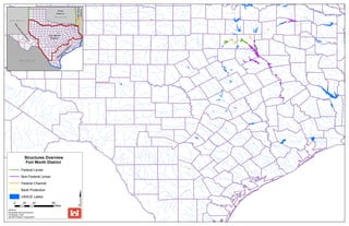
  • 1. Tulsa District Albuquerque District Fort Worth District Galveston District Little Rock District Mee xx ii cc oo OOkkllaahhoommaa NNeeww MMeexxiiccoo Structures Overview Fort Worth District Federal Levee Non-Federal Levee Federal Channel Bank Protection USACE Lakes 0 20 40 80 Miles 4/2/2014 Geospatial Services Section Eli Kangas, Chief Jennifer Holland, Geographer
  • 2. A n d e r s o n C o u n t y F r e e s t o n e C o u n t y 2 L e o n C o u n t y Non-Federal Levees 1 2 3 Anderson LID 2 Trinity LB Henderson LID 3 Trinity LB N a v a r r o C o u n t y H o u s t o n 3 1 Anderson LID 1 Cedar Lake LB RIP Status Fort Worth District Anderson County, Texas This product is reproduced from geospatial information prepared by the U.S. Army Corps of Engineers. GIS data and product accuracy may vary. Data may be: developed from sources of differing accuracy, accurate only at certain scales, based on modeling or interpretation, incomplete while being created or revised, etc. Using GIS products for purposes other than those for which they were created may yield inaccurate or misleading results. The Corps of Engineers reserves the right to correct, update, modify, or replace GIS products without notification. For more information contact the Fort Worth District L i m e s t o n e C o u n t y C o u n t y H o u s t o n C o u n t y L e o n C o u n t y N a v a r r o C o u n t y A n d e r s o n C o u n t y C h e r o k e e C o u n t y H e n d e r s o n C o u n t y F r e e s t o n e C o u n t y L i m e s t o n e C o u n t y S m i t h C o u n t y E l l i s C o u n t y R o b e r t s o n C o u n t y T r i n i t y C o u n t y Va n Z a n d t C o u n t y K a u f m a n C o u n t y F a l l s C o u n t y M a d i s o n C o u n t y H i l l C o u n t y W a l k e r C o u n t y 0 2 4 8 Miles Eligible for RIP Not Eligible for RIP 4/1/2014 Geospatial Services Section Eli Kangas, Chief Jennifer Holland, Geographer Geospatial Office.
  • 3. A t a s c o s a C o u n t y W i l s o n C o u n t y B e x a r C o u n t y 1 2 Federal Channels 1 Poteet Channel 2 Pleasanton Flood Channel B e x a r C o u n t y A t a s c o s a C o u n t y W i l s o n C o u n t y M e d i n a C o u n t y F r i o C o u n t y K a r n e s C o u n t y RIP Status Fort Worth District Atascosa County, Texas 0 0.75 1.5 3 Miles Eligible for RIP Not Eligible for RIP 4/1/2014 This product is reproduced from geospatial information prepared by the U.S. Army Corps of Engineers. GIS data and product accuracy may vary. Data may be: developed from sources of differing accuracy, accurate only at certain scales, based on modeling or interpretation, incomplete while being created or revised, etc. Using GIS products for purposes other than those for which they were created may yield inaccurate or misleading results. The Corps of Engineers reserves the right to correct, update, modify, or replace GIS products without notification. For more information contact the Fort Worth District Geospatial Services Section Eli Kangas, Chief Jennifer Holland, Geographer Geospatial Office.
  • 4. B a s t r o p C o u n t y L e e C o u n t y WWii ll ll oo ww CC rr ee ee kk F a y e t t e C o u n t y GG aa zz ll ee yy CC rr ee ee kk JJ DD CC rree ee kk Hunt Branch AAlluumm CC rr ee ee kk WWooll ff CC rr ee eekk Wolf Creek 1 Bank Protection 1 Colorado River Channel B a s t r o p C o u n t y F a y e t t e C o u n t y RIP Status Fort Worth District Bastrop County, Texas 0 0.3 0.6 1.2 Miles Eligible for RIP Not Eligible for RIP 4/1/2014 This product is reproduced from geospatial information prepared by the U.S. Army Corps of Engineers. GIS data and product accuracy may vary. Data may be: developed from sources of differing accuracy, accurate only at certain scales, based on modeling or interpretation, incomplete while being created or revised, etc. Using GIS products for purposes other than those for which they were created may yield inaccurate or misleading results. The Corps of Engineers reserves the right to correct, update, modify, or replace GIS products without notification. For more information contact the Fort Worth District Geospatial Services Section Eli Kangas, Chief Jennifer Holland, Geographer Geospatial Office.
  • 5. B e x a r C o u n t y SSaa nn AAnn tt oo nn ii oo RR ii vvee rr AA ll aa zz aa nn CC rr ee ee kk RIP Status Fort Worth District Bexar County, Texas San Pedro Creek 1 2 Federal Channel 1 San Antonio Channel 2 San Antonio Channel B e x a r C o u n t y 0 0.225 0.45 0.9 Miles Eligible for RIP Not Eligible for RIP 4/1/2014 This product is reproduced from geospatial information prepared by the U.S. Army Corps of Engineers. GIS data and product accuracy may vary. Data may be: developed from sources of differing accuracy, accurate only at certain scales, based on modeling or interpretation, incomplete while being created or revised, etc. Using GIS products for purposes other than those for which they were created may yield inaccurate or misleading results. The Corps of Engineers reserves the right to correct, update, modify, or replace GIS products without notification. For more information contact the Fort Worth District Geospatial Services Section Eli Kangas, Chief Jennifer Holland, Geographer Geospatial Office.
  • 6. C o o k e C o u n t y PPee cc aann CC rreeeekk WW hh eeee llee rr CCrr ee ee kk L o v e C o u n t y RR ee dd mm oo nn dd BB rr aa nn cchh ii vv ee rr EE ll mm FF oo rr kk TT rr ii nn ii tt yy RR Non-Federal Levee 1 Leonard Park Elm Fork LB RIP Status Fort Worth District Cooke County, Texas This product is reproduced from geospatial information prepared by the U.S. Army Corps of Engineers. GIS data and product accuracy may vary. Data may be: developed from sources of differing accuracy, accurate only at certain scales, based on modeling or interpretation, incomplete while being created or revised, etc. Using GIS products for purposes other than those for which they were created may yield inaccurate or misleading results. The Corps of Engineers reserves the right to correct, update, modify, or replace GIS products without notification. For more information contact the Fort Worth District SS cc oo tt tt CC rr ee ee kk DD oo zz ii ee rr CC rr ee ee kk RR oo cc kk CC rree eekk MMoo nn tt aa gg uu ee CC rr ee ee kk 1 2 Federal Channel 2 Wheeler Creek Channel C o o k e C o u n t y 0 0.3 0.6 1.2 Miles Eligible for RIP Not Eligible for RIP 4/1/2014 Geospatial Services Section Eli Kangas, Chief Jennifer Holland, Geographer Geospatial Office.
  • 7. D a l l a s C o u n t y Federal Levee 1 Bois D’Arc Levee Trinity LB 2 Central WWTP Trinity RB 3 East Dallas Levee Trinity LB 4 Irving Levee (IFCD-1 East) 5 Irving Levee (IFCD-1 West) 6 Rochester Levee Trinity LB 7 West Dallas Levee Trinity RB 9 Dallas LID 14 Trinity RB 10 Dallas LID 2 Trinity RB 11 Kaufman LID 15 East Fork Trinity LB 12 Kaufman LID 6 East Fork Trinity RB 13 Kaufman LID 8 East Fork Trinity RB 14 Dallas Floodway Channel 15 Delaware Creek Channel 16 Dry Branch Channel 17 Duck Creek Channel 18 Hutton Branch Channel 19 Ten Mile Creek Channel T a r r a n t C o u n t y F a n n i n C o u n t y R o c k w a l l C o u n t y K a u f m a n C o u n t y E l l i s C o u n t y C o l l i n C o u n t y D e n t o n C o u n t y 4/1/2014 Fort Worth District This product is reproduced from geospatial information prepared by the U.S. Army Corps of Engineers. GIS data and product accuracy may vary. Data may be: developed from sources of differing accuracy, accurate only at certain scales, based on modeling or interpretation, incomplete while being created or revised, etc. Using GIS products for purposes other than those for which they were created may yield inaccurate or misleading results. The Corps of Engineers reserves the right to correct, update, modify, or replace GIS products without notification. For more information contact the Fort Worth District J o h n s o n C o u n t y 5 D e n t o n C o u n t y W i s e C o u n t y 16 12 14 13 7 8 3 17 11 9 10 18 1 2 4 15 22 20 19 21 6 Non-Federal Levee 8 Dallas LID 1 Trinity RB Federal Channel Bank Protection 20 Cottonwook Creek Bank Protection 21 Grand Prairie Sanitary Landfill Bank Protection 22 Bank Protection, Meyers Rd D a l l a s C o u n t y E l l i s C o u n t y Ta r r a n t C o u n t y C o l l i n C o u n t y H u n t C o u n t y K a u f m a n C o u n t y J o h n s o n C o u n t y N a v a r r o C o u n t y H i l l C o u n t y R o c k w a l l C o u n t y RIP Status Dallas County, Texas 0 1.75 3.5 7 Miles Eligible for RIP Not Eligible for RIP Geospatial Services Section Eli Kangas, Chief Jennifer Holland, Geographer Geospatial Office.
  • 8. Non-Federal Levee 1 Lamar LID 1 North Sulphur RB RIP Status Fort Worth District C o o p e r D a m / J i m C h a p m a n L a k e H o p k i n s C o u n t y D e l t a C o u n t y L a m a r C o u n t y R e d R i v e r C o u n t y F r a n k l i n C o u n t y 4 3 1 2 2 Franklin LID 1 Sulphur RB 3 Delta LID 1 South Sulphur RB 4 Delta LID 1 South Sulphur LB L a m a r C o u n t y H o p k i n s C o u n t y R e d R i v e r C o u n t y F a n n i n C o u n t y H u n t C o u n t y D e l t a C o u n t y T i t u s C o u n t y C a m p C o u n t y F r a n k l i n C o u n t y Wo o d C o u n t y R a i n s C o u n t y M c C u r t a i n C o u n t y Delta County, Texas 0 1.25 2.5 5 Miles Eligible for RIP Not Eligible for RIP 4/1/2014 This product is reproduced from geospatial information prepared by the U.S. Army Corps of Engineers. GIS data and product accuracy may vary. Data may be: developed from sources of differing accuracy, accurate only at certain scales, based on modeling or interpretation, incomplete while being created or revised, etc. Using GIS products for purposes other than those for which they were created may yield inaccurate or misleading results. The Corps of Engineers reserves the right to correct, update, modify, or replace GIS products without notification. For more information contact the Fort Worth District Geospatial Services Section Eli Kangas, Chief Jennifer Holland, Geographer Geospatial Office.
  • 9. D e n t o n C o u n t y D a l l a s C o u n t y FF uu rr nn ee aa uu xx CC rr ee ee kk II nndd iiaa nn CCrree ee kk Bank Protection Dudley Branch Furneaux Creek 1 1 McCoy Rd Bank Protection D e n t o n C o u n t y D a l l a s C o u n t y RIP Status Fort Worth District Denton County, Texas 0 0.125 0.25 0.5 Miles Eligible for RIP Not Eligible for RIP 4/1/2014 This product is reproduced from geospatial information prepared by the U.S. Army Corps of Engineers. GIS data and product accuracy may vary. Data may be: developed from sources of differing accuracy, accurate only at certain scales, based on modeling or interpretation, incomplete while being created or revised, etc. Using GIS products for purposes other than those for which they were created may yield inaccurate or misleading results. The Corps of Engineers reserves the right to correct, update, modify, or replace GIS products without notification. For more information contact the Fort Worth District Geospatial Services Section Eli Kangas, Chief Jennifer Holland, Geographer Geospatial Office.
  • 10. B a r d w e l l L a k e Non-Federal Levees J o e P o o l L a k e E l l i s C o u n t y Ta r r a n t C o u n t y J o h n s o n C o u n t y N a v a r r o C o u n t y D a l l a s C o u n t y E l l i s C o u n t y K a u f m a n C o u n t y D a l l a s C o u n t y 1 Navarro LID 1 Chambers LB 2 Ellis LID 3 Trinity RB 3 Ellis LID 2 Trinity RB 4 Ellis LID 1 Chambers LB 5 Ellis LID 6 Onion LB 6 Ellis LID 4 Waxahachie RB 7 Ellis LID 10 Trinity RB Fort Worth District This product is reproduced from geospatial information prepared by the U.S. Army Corps of Engineers. GIS data and product accuracy may vary. Data may be: developed from sources of differing accuracy, accurate only at certain scales, based on modeling or interpretation, incomplete while being created or revised, etc. Using GIS products for purposes other than those for which they were created may yield inaccurate or misleading results. The Corps of Engineers reserves the right to H i l l C o u n t y H u n t C o u n t y R o c k w a l l C o u n t y K a u f m a n C o u n t y H e n d e r s o n C o u n t y H e n d e r s o n C o u n t y 5 4 5 3 6 7 1 2 RIP Status Ellis County, Texas 0 1.75 3.5 7 Miles Eligible for RIP Not Eligible for RIP 4/1/2014 correct, update, modify, or replace GIS products without notification. For more information contact the Fort Worth District Geospatial Services Section Eli Kangas, Chief Jennifer Holland, Geographer Geospatial Office. N a v a r r o H i l l C o u n t y C o u n t y F r e e s t o n e C o u n t y B o s q u e C o u n t y L i m e s t o n e C o u n t y A n d e r s o n C o u n t y
  • 11. R e d R i v e r C o u n t y F r a n k l i n C o u n t y Non-Federal Levees 1 Franklin LID 1 Sulphur RB L a m a r C o u n t y D e l t a C o u n t y tt hh SS uull pphh uu rr RR ii vv ee rr uu RIP Status Fort Worth District Franklin County, Texas H o p k i n s C o u n t y Sulphur River eeee kk CC oo bbbb JJ oo nn eess CC rr MM uu ss tt aann gg CC rr ee eekk SSoo 1 1 0 0.3 0.6 1.2 Miles Eligible for RIP Not Eligible for RIP 4/1/2014 This product is reproduced from geospatial information prepared by the U.S. Army Corps of Engineers. GIS data and product accuracy may vary. Data may be: developed from sources of differing accuracy, accurate only at certain scales, based on modeling or interpretation, incomplete while being created or revised, etc. Using GIS products for purposes other than those for which they were created may yield inaccurate or misleading results. The Corps of Engineers reserves the right to correct, update, modify, or replace GIS products without notification. For more information contact the Fort Worth District Geospatial Services Section Eli Kangas, Chief Jennifer Holland, Geographer Geospatial Office. R e d R i v e r C o u n t y F r a n k l i n C o u n t y L a m a r C o u n t y D e l t a C o u n t y H o p k i n s C o u n t y
  • 12. G u a d a l u p e C o u n t y Federal Channel C o m a l C o u n t y 1 Walnut Branch Channel 4/1/2014 Fort Worth District This product is reproduced from geospatial information prepared by the U.S. Army Corps of Engineers. GIS data and product accuracy may vary. Data may be: developed from sources of differing accuracy, accurate only at certain scales, based on modeling or interpretation, incomplete while being created or revised, etc. Using GIS products for purposes other than those for which they were created may yield inaccurate or misleading results. The Corps of Engineers reserves the right to correct, update, modify, or replace GIS products without notification. For more information contact the Fort Worth District B e x a r C o u n t y 1 RIP Status Guadalupe County, Texas 0 0.75 1.5 3 Miles Eligible for RIP Not Eligible for RIP Geospatial Services Section Eli Kangas, Chief Jennifer Holland, Geographer Geospatial Office. H a y s C o u n t y G u a d a l u p e C o u n t y C o m a l C o u n t y B e x a r C o u n t y C a l d w e l l C o u n t y G o n z a l e s C o u n t y W i l s o n C o u n t y
  • 13. N a v a r r o C o u n t y H i l l C o u n t y H e n d e r s o n C o u n t y Non-Federal Levees 1 Henderson LID 1 Trinity LB 2 Henderson LID 3 Trinity LB E l l i s C o u n t y K a u f m a n C o u n t y V a n Z a n d t C o u n t y A n d e r s o n C o u n t y F r e e s t o n e C o u n t y 1 2 RIP Status Fort Worth District Henderson County, Texas 0 1.5 3 6 Miles Eligible for RIP Not Eligible for RIP 4/1/2014 This product is reproduced from geospatial information prepared by the U.S. Army Corps of Engineers. GIS data and product accuracy may vary. Data may be: developed from sources of differing accuracy, accurate only at certain scales, based on modeling or interpretation, incomplete while being created or revised, etc. Using GIS products for purposes other than those for which they were created may yield inaccurate or misleading results. The Corps of Engineers reserves the right to correct, update, modify, or replace GIS products without notification. For more information contact the Fort Worth District Geospatial Services Section Eli Kangas, Chief Jennifer Holland, Geographer Geospatial Office. N a v a r r o C o u n t y E l l i s C o u n t y H e n d e r s o n C o u n t y K a u f m a n C o u n t y Va n Z a n d t C o u n t y F r e e s t o n e C o u n t y A n d e r s o n C o u n t y D a l l a s C o u n t y L i m e s t o n e C o u n t y
  • 14. Non-Federal Levees 1 Hopkins LID 1 South Sulphur RB CCaann nn oonn CCrr eeee kk C o o p e r D a m / J i m C h a p m a n L a k e D e l t a C o u n t y H o p k i n s C o u n t y SS oo uu tt hh SS uu ll pp hh uu rr RR ii vv ee rr BB ii gg CC rr eeee kk BBrr uu ss hh yy CC rr eeeekk MM oo rr ggaann CCrreeee kk VVaa ddeenn CCrr eeeekk CCrr oo ss ss tt iimm bb ee rr CC rr ee ee kk BB oo yy dd BB rr aann cc hh WWoo ll ff CCrr ee ee kk DD oo cc tt oorr ss CC rr ee ee kk EEvvaa nn ss BB rr aanncc hh LLaa kk ee CC rr ee eekk oo gg ss tt oo nn BB rr aa nn cchh LL LL ii tt tt ll ee CC aa nn ee yy CC rr ee ee kk WW oo ll ffpp ee nn CC rr eeee kk MMoooorree CC rr eeee kk MM cc GG uu yy ee rr BB rr aa nncchh GGrree eennbbrr ii eerr BB rr aa nn cchh NN oo rr tt hh CC aannee yy CC rr ee ee kk RR ee dd BB rr aa nn cc hh PP oo ss tt OOaakk CCrree ee kk EE aa ss tt FF oo rr kk BBiigg CCrree ee kk FF ii nn ll ee yy BBrr aa nn cc hh SS oo uu tt hh SS uu ll pp hh uu rr RR ii vv ee rr 1 2 RIP Status Fort Worth District Hopkins County, Texas 0 0.5 1 2 Miles Eligible for RIP Not Eligible for RIP 4/1/2014 This product is reproduced from geospatial information prepared by the U.S. Army Corps of Engineers. GIS data and product accuracy may vary. Data may be: developed from sources of differing accuracy, accurate only at certain scales, based on modeling or interpretation, incomplete while being created or revised, etc. Using GIS products for purposes other than those for which they were created may yield inaccurate or misleading results. The Corps of Engineers reserves the right to correct, update, modify, or replace GIS products without notification. For more information contact the Fort Worth District Geospatial Services Section Eli Kangas, Chief Jennifer Holland, Geographer Geospatial Office. D e l t a C o u n t y H o p k i n s C o u n t y L a m a r C o u n t y
  • 15. N a v a r r o C o u n t y L i m e s t o n e C o u n t y H o u s t o n C o u n t y L e o n C o u n t y M a d i s o n C o u n t y R u s k C o u n t y A n g e l i n a C o u n t y T r i n i t y C o u n t y Non-Federal Levees F r e e s t o n e C o u n t y A n d e r s o n C o u n t y W a l k e r C o u n t y 3 1 2 1 Anderson LID 2 Trinity LB 2 Houston LID 2 Trinity LB 3 Houston LID 1 Trinity LB RIP Status Fort Worth District Houston County, Texas 0 2 4 8 Miles Eligible for RIP Not Eligible for RIP 4/1/2014 This product is reproduced from geospatial information prepared by the U.S. Army Corps of Engineers. GIS data and product accuracy may vary. Data may be: developed from sources of differing accuracy, accurate only at certain scales, based on modeling or interpretation, incomplete while being created or revised, etc. Using GIS products for purposes other than those for which they were created may yield inaccurate or misleading results. The Corps of Engineers reserves the right to correct, update, modify, or replace GIS products without notification. For more information contact the Fort Worth District Geospatial Services Section Eli Kangas, Chief Jennifer Holland, Geographer Geospatial Office. H o u s t o n C o u n t y L e o n C o u n t y A n d e r s o n C o u n t y T r i n i t y C o u n t y F r e e s t o n e C o u n t y C h e r o k e e C o u n t y W a l k e r C o u n t y M a d i s o n C o u n t y P o l k C o u n t y B r a z o s C o u n t y G r i m e s C o u n t y R o b e r t s o n C o u n t y S a n J a c i n t o C o u n t y
  • 16. H o w a r d C o u n t y Federal Channel 1 Beals Creek Channel M a r t i n C o u n t y 1 RIP Status Fort Worth District Howard County, Texas 0 1 2 4 Miles Eligible for RIP Not Eligible for RIP 4/1/2014 This product is reproduced from geospatial information prepared by the U.S. Army Corps of Engineers. GIS data and product accuracy may vary. Data may be: developed from sources of differing accuracy, accurate only at certain scales, based on modeling or interpretation, incomplete while being created or revised, etc. Using GIS products for purposes other than those for which they were created may yield inaccurate or misleading results. The Corps of Engineers reserves the right to correct, update, modify, or replace GIS products without notification. For more information contact the Fort Worth District Geospatial Services Section Eli Kangas, Chief Jennifer Holland, Geographer Geospatial Office. H o w a r d C o u n t y D a w s o n C o u n t y M a r t i n C o u n t y G l a s s c o c k C o u n t y M i t c h e l l C o u n t y B o r d e n C o u n t y S t e r l i n g C o u n t y M i d l a n d C o u n t y S c u r r y C o u n t y
  • 17. H u n t C o u n t y Federal Channel 1 Long Branch Creek Channel C o l l i n C o u n t y 1 RIP Status Fort Worth District Hunt County, Texas 0 1 2 4 Miles Eligible for RIP Not Eligible for RIP 4/1/2014 This product is reproduced from geospatial information prepared by the U.S. Army Corps of Engineers. GIS data and product accuracy may vary. Data may be: developed from sources of differing accuracy, accurate only at certain scales, based on modeling or interpretation, incomplete while being created or revised, etc. Using GIS products for purposes other than those for which they were created may yield inaccurate or misleading results. The Corps of Engineers reserves the right to correct, update, modify, or replace GIS products without notification. For more information contact the Fort Worth District Geospatial Services Section Eli Kangas, Chief Jennifer Holland, Geographer Geospatial Office. H u n t C o u n t y C o l l i n C o u n t y F a n n i n C o u n t y D e l t a C o u n t y H o p k i n s C o u n t y R a i n s C o u n t y R o c k w a l l C o u n t y K a u f m a n C o u n t y G r a y s o n C o u n t y Va n Z a n d t C o u n t y L a m a r C o u n t y
  • 18. B a r d w e l l L a k e K a u f m a n C o u n t y D a l l a s C o u n t y E l l i s C o u n t y D a l l a s C o u n t y H e n d e r s o n C o u n t y R o c k w a l l C o u n t y N a v a r r o C o u n t y 8 3 5 4 6 7 2 1 Federal Channel 11 East Fork Floodway Channel RIP Status Fort Worth District Kaufman County, Texas 0 1.75 3.5 7 Miles Eligible for RIP Not Eligible for RIP 4/1/2014 This product is reproduced from geospatial information prepared by the U.S. Army Corps of Engineers. GIS data and product accuracy may vary. Data may be: developed from sources of differing accuracy, accurate only at certain scales, based on modeling or interpretation, incomplete while being created or revised, etc. Using GIS products for purposes other than those for which they were created may yield inaccurate or misleading results. The Corps of Engineers reserves the right to correct, update, modify, or replace GIS products without notification. For more information contact the Fort Worth District Geospatial Services Section Eli Kangas, Chief Jennifer Holland, Geographer Geospatial Office. E l l i s C o u n t y K a u f m a n C o u n t y N a v a r r o C o u n t y H u n t C o u n t y Ta r r a n t C o u n t y H i l l C o u n t y C o l l i n C o u n t y Va n Z a n d t C o u n t y H e n d e r s o n C o u n t y D e n t o n C o u n t y J o h n s o n C o u n t y R a i n s C o u n t y R o c k w a l l C o u n t y H o p k i n s C o u n t y A n d e r s o n C o u n t y Federal Levee 1 Kaufman 5 East, East Fork Trinity LB 2 Kaufman 5 West, East Fork Trinity RB 3 Kaufman MUD 1, East Fork Trinity LB Non-Federal Levee 4 Bois D’Arc Levee Trinity LB 5 Kaufman LID 1 East Fork Trinity LB 6 Kaufman LID 10 East Fork Trinity RB 7 Kaufman LID 13 East Fork Trinity LB 8 Kaufman LID 15 East Fork Trinity LB 9 Kaufman LID 6 East Fork Trinity LB 10 Kaufman LID 8 East Fork Trinity RB 9 10 11
  • 19. K n o x C o u n t y H a s k e l l C o u n t y B a y l o r C o u n t y T h r o c k m o r t o n C o u n t y 1 Federal Channel 1 Munday Channel RIP Status Fort Worth District Knox County, Texas Eligible for RIP Not Eligible for RIP 0 0.75 1.5 3 Miles 4/1/2014 This product is reproduced from geospatial information prepared by the U.S. Army Corps of Engineers. GIS data and product accuracy may vary. Data may be: developed from sources of differing accuracy, accurate only at certain scales, based on modeling or interpretation, incomplete while being created or revised, etc. Using GIS products for purposes other than those for which they were created may yield inaccurate or misleading results. The Corps of Engineers reserves the right to correct, update, modify, or replace GIS products without notification. For more information contact the Fort Worth District Geospatial Services Section Eli Kangas, Chief Jennifer Holland, Geographer Geospatial Office. K n o x C o u n t y H a s k e l l C o u n t y B a y l o r C o u n t y T h r o c k m o r t o n C o u n t y K i n g C o u n t y S t o n e w a l l C o u n t y F o a r d C o u n t y
  • 20. Non-Federal Levee 1 Lamar LID 1 North Sulphur RB RIP Status Fort Worth District Lamar County, Texas This product is reproduced from geospatial information prepared by the U.S. Army Corps of Engineers. GIS data and product accuracy may vary. Data may be: developed from sources of differing accuracy, accurate only at certain scales, based on modeling or interpretation, incomplete while being created or revised, etc. Using GIS products for purposes other than those for which they were created may yield inaccurate or misleading results. The Corps of Engineers reserves the right to C o o p e r D a m / J i m C h a p m a n L a k e L a m a r C o u n t y H o p k i n s C o u n t y D e l t a C o u n t y R e d R i v e r C o u n t y F r a n k l i n C o u n t y 1 0 1 2 4 Miles Eligible for RIP Not Eligible for RIP 4/1/2014 correct, update, modify, or replace GIS products without notification. For more information contact the Fort Worth District Geospatial Services Section Eli Kangas, Chief Jennifer Holland, Geographer Geospatial Office. L a m a r C o u n t y H o p k i n s C o u n t y R e d R i v e r C o u n t y D e l t a C o u n t y F r a n k l i n C o u n t y T i t u s C o u n t y F a n n i n C o u n t y H u n t C o u n t y C a m p C o u n t y
  • 21. M c L e n n a n C o u n t y Flat Creek CC rr ee ee kk SS hh aa ww CC oo tt tt oonn ww oo oodd CC rr ee eekk TT ee hhuu aa cc aa nn aa CC rr ee ee kk Bank Protection 1 Brazos River Wastewater Treatment Plant Bank Protection WWaa cc ooCC rr eeeekk TT rr aadd ii nn gghh oo uu ss ee CC rr ee ee kk 1 RIP Status Fort Worth District McLennan County, Texas 0 0.25 0.5 1 Miles Eligible for RIP Not Eligible for RIP 4/1/2014 This product is reproduced from geospatial information prepared by the U.S. Army Corps of Engineers. GIS data and product accuracy may vary. Data may be: developed from sources of differing accuracy, accurate only at certain scales, based on modeling or interpretation, incomplete while being created or revised, etc. Using GIS products for purposes other than those for which they were created may yield inaccurate or misleading results. The Corps of Engineers reserves the right to correct, update, modify, or replace GIS products without notification. For more information contact the Fort Worth District Geospatial Services Section Eli Kangas, Chief Jennifer Holland, Geographer Geospatial Office. M c L e n n a n C o u n t y F a l l s C o u n t y
  • 22. Non-Federal Levee 1 Hefley LID Little River RB RIP Status Fort Worth District G r a n g e r L a k e M i l a m C o u n t y B e l l C o u n t y Milam County, Texas W i l l i a m s o n C o u n t y B u r l e s o n C o u n t y 1 0 1.25 2.5 5 Miles Eligible for RIP Not Eligible for RIP 4/1/2014 This product is reproduced from geospatial information prepared by the U.S. Army Corps of Engineers. GIS data and product accuracy may vary. Data may be: developed from sources of differing accuracy, accurate only at certain scales, based on modeling or interpretation, incomplete while being created or revised, etc. Using GIS products for purposes other than those for which they were created may yield inaccurate or misleading results. The Corps of Engineers reserves the right to correct, update, modify, or replace GIS products without notification. For more information contact the Fort Worth District Geospatial Services Section Eli Kangas, Chief Jennifer Holland, Geographer Geospatial Office. M i l a m C o u n t y B e l l C o u n t y W i l l i a m s o n C o u n t y B u r l e s o n C o u n t y L e e C o u n t y R o b e r t s o n C o u n t y F a l l s C o u n t y T r a v i s C o u n t y B a s t r o p C o u n t y B r a z o s C o u n t y W a s h i n g t o n C o u n t y C o r y e l l C o u n t y
  • 23. Non-Federal Levee 1 Henderson LID 3 Trinity LB 2 Lewis Simpson Trinity RB 3 Navarro LID 1 Chambers LB 4 Navarro LID 10 Chambers LB 5 Navarro LID 10 Chambers RB 6 Navarro LID 11 Chambers LB 7 Navarro LID 3 Trinity RB 8 Navarro LID 4 Chambers RB 9 Navarro LID 6 Chambers RB 10 Pettigrew Levee Trinity RB B a r d w e l l L a k e N a v a r r o C o u n t y H e n d e r s o n C o u n t y E l l i s C o u n t y K a u f m a n C o u n t y F r e e s t o n e C o u n t y R a i n s C o u n t y V a n Z a n d t C o u n t y A n d e r s o n C o u n t y 5 10 3 8 1 6 7 4 2 9 RIP Status Fort Worth District Navarro County, Texas 0 1.5 3 6 Miles Eligible for RIP Not Eligible for RIP 4/1/2014 This product is reproduced from geospatial information prepared by the U.S. Army Corps of Engineers. GIS data and product accuracy may vary. Data may be: developed from sources of differing accuracy, accurate only at certain scales, based on modeling or interpretation, incomplete while being created or revised, etc. Using GIS products for purposes other than those for which they were created may yield inaccurate or misleading results. The Corps of Engineers reserves the right to correct, update, modify, or replace GIS products without notification. For more information contact the Fort Worth District Geospatial Services Section Eli Kangas, Chief Jennifer Holland, Geographer Geospatial Office. N a v a r r o C o u n t y E l l i s C o u n t y K a u f m a n C o u n t y H e n d e r s o n C o u n t y F r e e s t o n e C o u n t y Va n Z a n d t C o u n t y A n d e r s o n C o u n t y D a l l a s C o u n t y H i l l C o u n t y L i m e s t o n e C o u n t y L e o n C o u n t y
  • 24. R e d R i v e r C o u n t y F r a n k l i n C o u n t y Non-Federal Levee 1 Red River LID 1 Sulphur LB L a m a r C o u n t y RIP Status Fort Worth District Red River County, Texas D e l t a C o u n t y This product is reproduced from geospatial information prepared by the U.S. Army Corps of Engineers. GIS data and product accuracy may vary. Data may be: developed from sources of differing accuracy, accurate only at certain scales, based on modeling or interpretation, incomplete while being created or revised, etc. Using GIS products for purposes other than those for which they were created may yield inaccurate or misleading results. The Corps of Engineers reserves the right to H o p k i n s C o u n t y Sulphur River MM uu ss tt aa nn gg CC rr ee ee kk LL iitt tt ll ee SS aa nn dd yy CCrr ee ee kk WWhh ii tt ee OO aa kk BBrr aa nn cc hh SS oo uu tt hh SS uu ll pp hh uu rr RR ii vv ee rr tthh SS uu ll pphh uu rr RR ii vv ee rr uu SSoo 1 0 0.3 0.6 1.2 Miles Eligible for RIP Not Eligible for RIP 4/1/2014 correct, update, modify, or replace GIS products without notification. For more information contact the Fort Worth District Geospatial Services Section Eli Kangas, Chief Jennifer Holland, Geographer Geospatial Office. R e d R i v e r C o u n t y F r a n k l i n C o u n t y L a m a r C o u n t y D e l t a C o u n t y H o p k i n s C o u n t y
  • 25. Federal Levee 2 Brookside Levee West Fork LB 3 Carswell Levee West Fork LB 4 Clear Fork Levee Loop Clear Fork LB 5 Crestwood Levee West Fork RB 6 North Main Levee Loop West Fork LB 7 Overton Levee Clear Fork RB 8 Sump #6 Levee West Fork LB 9 Watermelon Levee Clear Fork RB 10 West Fork Levee Loop West Fork RB 11 White Settlement Levee West Fork RB 23 Indian Creek Bank Protection RIP Status Fort Worth District Tarrant County, Texas This product is reproduced from geospatial information prepared by the U.S. Army Corps of Engineers. GIS data and product accuracy may vary. Data may be: developed from sources of differing accuracy, accurate only at certain scales, based on modeling or interpretation, incomplete while being created or revised, etc. Using GIS products for purposes other than those for which they were created may yield inaccurate or misleading results. The Corps of Engineers reserves the right to correct, update, modify, or replace GIS products without notification. For more information contact the Fort Worth District Federal Channel 13 Big Fossil Floodway Channel 14 Calloway Branch Channel 15 Fort Worth Floodway West Fork Above Clear Fork Channel 17 Fort Worth Floodway Clear Fork Channel 19 Lorean Branch Channel 20 Rush Creek Channel 21 Singing Hills Channel B e n b r o o k R e s e r v o i r J o e P o o l L a k e T a r r a n t C o u n t y P a r k e r C o u n t y 3 10 5 8 1 6 7 4 2 9 1 Big Fossil Creek Levee Big Fossil LB Ta r r a n t C o u n t y P a r k e r C o u n t y D e n t o n C o u n t y D a l l a s C o u n t y J o h n s o n C o u n t y W i s e C o u n t y E l l i s C o u n t y H o o d C o u n t y C o l l i n C o u n t y 0 1 2 4 Miles Eligible for RIP Not Eligible for RIP 4/1/2014 Geospatial Services Section Eli Kangas, Chief Jennifer Holland, Geographer Geospatial Office. Non-Federal Levee Bank Protection 12 Waterworks Levee Clear Fork RB 26 Arlington Landfill Bank Protection 27 River Oaks Bank Protection 18 Johnson Creek Channel 25 Park Row Bridge Bank Protection 22 Sulphur Branch Channel 11 12 13 14 15 16 Fort Worth Floodway West Fork Below Clear Fork Channel 16 17 18 19 20 21 22 24 Marys Creek Bank Protection 27 26 25 24 23
  • 26. J o n e s C o u n t y T a y l o r C o u n t y Elm Creek CCee dd aarr CC rr ee ee kk RRaa ii nn yy CC rr eeee kk IInn dd ii aa nnCCrr ee ee kk CCllaaww CC rr ee ee kk CCaa tt LLiitt tt llee EEllmm CC rree ee kk BB uucc kkCCrree ee kk LLyytt llee CCrr ee eekk 1 Federal Channel 1 Cat Claw Creek Channel RIP Status Fort Worth District Taylor County, Texas 0 0.4 0.8 1.6 Miles Eligible for RIP Not Eligible for RIP 4/1/2014 This product is reproduced from geospatial information prepared by the U.S. Army Corps of Engineers. GIS data and product accuracy may vary. Data may be: developed from sources of differing accuracy, accurate only at certain scales, based on modeling or interpretation, incomplete while being created or revised, etc. Using GIS products for purposes other than those for which they were created may yield inaccurate or misleading results. The Corps of Engineers reserves the right to correct, update, modify, or replace GIS products without notification. For more information contact the Fort Worth District Geospatial Services Section Eli Kangas, Chief Jennifer Holland, Geographer Geospatial Office. J o n e s C o u n t y T a y l o r C o u n t y S h a c k e l f o r d C o u n t y C a l l a h a n C o u n t y
  • 27. T r a v i s C o u n t y B a s t r o p C o u n t y Federal Channel 1 Boggy Creek Channel RIP Status Fort Worth District Travis County, Texas This product is reproduced from geospatial information prepared by the U.S. Army Corps of Engineers. GIS data and product accuracy may vary. Data may be: developed from sources of differing accuracy, accurate only at certain scales, based on modeling or interpretation, incomplete while being created or revised, etc. Using GIS products for purposes other than those for which they were created may yield inaccurate or misleading results. The Corps of Engineers reserves the right to H a y s C o u n t y 1 0 1 2 4 Miles Eligible for RIP Not Eligible for RIP 4/1/2014 correct, update, modify, or replace GIS products without notification. For more information contact the Fort Worth District Geospatial Services Section Eli Kangas, Chief Jennifer Holland, Geographer Geospatial Office. T r a v i s C o u n t y B a s t r o p C o u n t y B l a n c o C o u n t y H a y s C o u n t y W i l l i a m s o n C o u n t y C a l d w e l l C o u n t y B u r n e t C o u n t y L e e C o u n t y C o m a l C o u n t y
  • 28. W e b b C o u n t y Z a p a t a C o u n t y 1 Federal Channel 1 Zacate Creek Channel RIP Status Fort Worth District Webb County, Texas 0 2.25 4.5 9 Miles Eligible for RIP Not Eligible for RIP 4/1/2014 This product is reproduced from geospatial information prepared by the U.S. Army Corps of Engineers. GIS data and product accuracy may vary. Data may be: developed from sources of differing accuracy, accurate only at certain scales, based on modeling or interpretation, incomplete while being created or revised, etc. Using GIS products for purposes other than those for which they were created may yield inaccurate or misleading results. The Corps of Engineers reserves the right to correct, update, modify, or replace GIS products without notification. For more information contact the Fort Worth District Geospatial Services Section Eli Kangas, Chief Jennifer Holland, Geographer Geospatial Office. D i m m i t C o u n t y M c M u l l e n We b b C o u n t y D u v a l C o u n t y Z a p a t a C o u n t y B r o o k s C o u n t y J i m H o g g C o u n t y L a S a l l e C o u n t y C o u n t y M a v e r i c k C o u n t y S t a r r C o u n t y