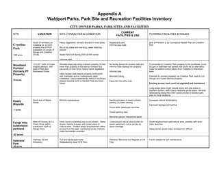
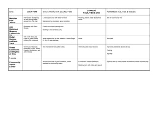
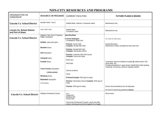
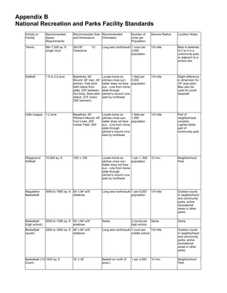
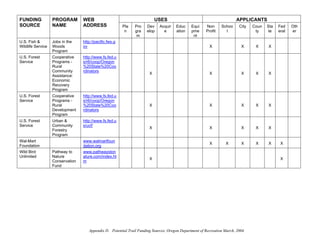
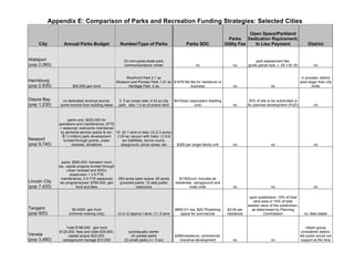
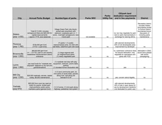
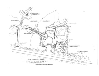
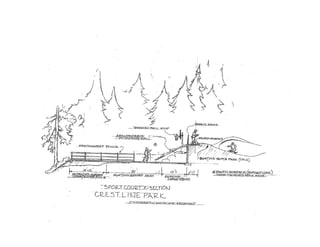
Waldport Parks and Recreation
Master Plan
February 2005


Prepared by the
Waldport Parks and Recreation Committee

With support from
Oregon Cascades West
Council of Governments
Table of Contents

                    Chapter 1: Introduction
                    Plan Purpose and Approach                      1-1
                    Relationship to Other Plans                    1-2
                    Plan Development                               1-3
                    Plan Organization                              1-3

                    Chapter 2: Community Profile
                    Geography and Climate                          2-1
                    Demographics                                   2-1

                    Chapter 3: Inventory of Park and Recreation
                    Resources
                    Park System Components                      3-1
                    Waldport Parks and Recreation Facilities    3-2
                    Undeveloped Park Sites                      3-6
                    Sports and Recreation Programs              3-6
                    Trails                                      3-7

                    Chapter 4: Needs Assessment
                    Recreation Trends                              4-1
                    Level of Service: Park Land                    4-2
                    Level of Service: Recreation Facilities        4-4
                    Needs and Projects Identified in Other Plans   4-5
                    Community Input                                4-8
                    Summary of Improvements and Additions          4-11

                    Chapter 5: Goals and Policies
                    Goal One                                       5-1
                    Goal Two                                       5-2
                    Goal Three                                     5-3
                    Goal Four                                      5-3

                    Chapter 6: Standards
                    Parks Standards                                6-1
                    Facility Standards                             6-3
                    Trail and Pathway Standards                    6-4

                    Chapter 7: Implementation Strategy
                    Short-Term Site and Facility Improvements      7-1
                    Longer-Term System Improvements                7-3
                    Other Critical Elements                        7-3
Chapter 8: Funding and Financing
             Mechanisms
             Elements of an Effective Funding Strategy   8-1
             Cost Estimates                              8-2
             Recommended Funding Approaches              8-2
             Summary                                     8-7


Maps

             Existing Parks and Recreation Resources
              And Undeveloped Park Sites                 3-5

             Proposed Trail Corridors                    6-5


Appendices
             A: Waldport Parks, Park Sites and Recreation Facilities
                Inventory

             B: NRPA Recreation Facility Standards

             C: Sources of Grant Funds

             D: Potential Trail Funding Sources

             E: Comparison of Parks and Recreation Funding
                Strategies: Selected Cities

             F: Crestline Park Conceptual Plan
The City of Waldport strives to provide park and
recreational facilities and programs that foster
community spirit, that contribute to the physical and
mental wellbeing of residents and visitors and that
preserve and enhance the community’s unique natural
landscape.

Chapter 1:
Introduction                 The City of Waldport, Oregon has exceptional outdoor
                             recreational opportunities supported by a community that
                             prides itself on small city quality of life, volunteerism, and
                             family activity. Waldport is surrounded by extensive natural
                             amenities - coastal beaches, the Alsea Bay and Alsea River
                                              estuary, and forested uplands. Waldport
                                              residents and visitors enjoy the many and
                                              varied gifts these natural areas offer. The
                                              residents of Waldport are active in a variety of
                                              sports and recreational activities, organized and
                                              offered through the city, the schools, and
                                              community organizations. The community
                                              strives to offer opportunities that meet the
                                              needs of all residents and relies on citizen
                                              engagement in the planning and development
                                              of our parks and recreational facilities and
   Alsea Bay                 programs. Use of these assets brings our residents together and
                             contributes to our unique sense of community and place.


      Plan Purpose and       The City of Waldport Parks and Recreation Committee, with
             Approach        assistance from Cascades West Council of Governments,
                             drafted this document to update and expand upon the 1998
                             Waldport Parks and Recreation Master Plan. The 2004 Parks
                             and Recreation Master Plan is a long-range plan with a twenty-
                             year planning horizon. It also includes a shorter-range strategy
                             to guide the City over the next five years as it pursues
                             implementation of the Master Plan.

                             The Master Plan identifies the community’s park and
                             recreation needs and desires, presents a comprehensive
                             community vision for the future of Waldport parks and
                             recreation, and establishes goals and a blueprint for action.

                             This Plan takes a systems approach to park and recreation
                             facilities and programs: individual components are viewed in
                             the context of an overall park and recreation system that
                             includes all facilities and programs available to area residents
                             Waldport Parks and Recreation Master Plan: Chapter 1      page 1-1
regardless of whether they are made available by the City, the
                          Port of Alsea, the Lincoln County School District or another
                          entity. Facilities and programs also are viewed in terms of
                          their programmatic and spatial interrelationships.

                          Keeping with the systems approach, the examination of needs
                          and the development of goals and policies, priorities and
                          actions integrate with the findings, strategies and
                          recommendations of other Waldport plans and strategies.


Relationship to Other As a functional plan specific to parks and recreation needs, the
                Plans Parks and Recreation Master Plan expands upon and is
                      consistent with the Waldport Comprehensive Plan, which
                      guides the growth and development of all lands within the
                      Waldport Urban Growth Boundary (UGB). The Master Plan
                      also has been drafted to be consistent with the requirements of
                      Statewide Planning Goal 8: Recreational Needs and associated
                      administrative rules (OAR 660-034-0040).

                          In developing the Master Plan, several local planning
                          documents were reviewed and relevant portions incorporated
                          into the Plan.

                          The Waldport Downtown Refinement Plan, (June 2003),
                          includes recommendations to improve the area’s economic
                          vitality, address traffic issues and promote a pedestrian-
                          friendly environment. The Plan is focused along Highway 101
                          from Alsea Bay to the sea wall and along Highway 34 between
                          Highway 101 and Cedar Streets.

                          The Waldport Urban Renewal Plan identifies public
                          improvements, such as landscaping and pedestrian amenities,
                          needed within the City’s urban renewal area.

                          The 2002 Interpretive Master Plan for the Port of Alsea
                          District identifies strategies that the Port District could use to
                          interpret the area’s scenic natural environment and cultural
                          history for residents and tourists, particularly in ways that
                          support the Port’s economic development mission.

                          The 2001 Resource Team Report for Waldport was prepared
                          by the Oregon Downtown Development Association and
                          recommends ways to support the business activity in Old Town
                          and along Highway 101.

                          The Waldport Transportation System Plan (1998-99)
                          includes a pedestrian and bikeway system element and

                          Waldport Parks and Recreation Master Plan: Chapter 1       page 1-2
prioritized list of associated projects and recommended
                       development code revisions.


Plan Development       The process of developing the Waldport Parks and Recreation
                       Plan included:
                          • An inventory and assessment of existing City parks and
                              recreation facilities and undeveloped lands intended for
                              park uses;
                          • An inventory and assessment of the other parks,
                              recreation and open space resources available to the
                              community (e.g. those provided by State Parks, the
                              Lincoln County School District and Port of Alsea);
                          • Engagement of the community to determine community
                              interests and priorities regarding parks and recreation
                              needs and opportunities and the determination of unmet
                              and future needs;
                          • Drafting of parks and recreation goals and policies;
                          • Prioritization of needs and opportunities; and
                          • Crafting of an implementation strategy and funding
                              recommendations.

                       A conceptual site plan for the development of the Crestline
                       Park site was drafted concurrent with the development of the
                       Master Plan, allowing the priorities for this key community
                       facility to be integrated into the Master Plan.


   Plan Organization   The Plan is divided into eight chapters. This chapter provides
                       general information about the purpose of the plan and its
                       relationship to other community or comprehensive plans,
                       planning and recreation resource documents and statutory
                       requirements.

                       Chapter 2 presents a physical and demographic profile of the
                       Waldport Community.

                       Chapter 3 includes the inventory of existing City-owned and
                       non-city owned parks, facilities, and related resources. The
                       inventory assessment describes existing park conditions,
                       evaluates current facilities, and identifies needed
                       improvements and known planned projects. This section also
                       identifies park and recreational facilities, organizations, open
                       space and trail systems either within the Urban Growth
                       Boundary (UGB) of Waldport or within a 7-mile radius. Other
                       organizations involved in the ownership and/or management of
                       these include the Port of Alsea, Oregon State Parks, Lincoln
                       County Parks, Lincoln County School District, Siuslaw

                       Waldport Parks and Recreation Master Plan: Chapter 1      page 1-3
National Forest, and various non-profit entities that support
                                        youth activities in the South Lincoln County region.

                                        Chapter 4 presents an analysis of park and recreational needs in
                                        Waldport. This chapter includes an assessment of trends in
                                        recreation in the region and summarizes the park and
                                        recreation needs identified through other planning processes,
                                        such as the Waldport Transportation System Plan. It also
                                        reports the recreational desires expressed locally through
                                        informational interviews conducted in the fall of 2003.
                                        Crucial to the evaluation of existing resources and facilities
                                        relative to community needs were discussions with
                                        organizational and community leaders, Waldport High School
                                        students, users of the South Lincoln Community/Senior Center,
                                        and insights provided by the City’s Parks and Recreation
                                        Committee.

                                        Chapter 5 presents Waldport’s park and recreation goals and
                                        policies. The goals articulate the parks and recreation outcomes
                                        that Waldport will strive for over the next twenty years. The
                                        policies provide direction as to how the City will proceed to
                                        achieve the goals.

                                        Chapter 6 presents the standards that the City of Waldport will
                                        use in making decisions regarding the location, site features,
                                        design and amenities for parks, trails and other recreation
                                        facilities.

                                        Chapter 7 is the short-term or five-year implementation
                                        strategy for the Parks and Recreation Master Plan.

                                        Chapter 8 recommends a funding and financing strategy for
                                        parks and recreation facilities.


In 2003, The Trust for Public Land published a report, The Excellent City Park System, which describes seven measures
                      of an excellent city park system developed by a panel of 25 urban park experts.

The goals of the Waldport Parks and Recreation Master Plan and the system envisioned by the Plan incorporate these
seven concepts with the anticipation that Waldport will grow its current park and recreation resources into its own
                                              Excellent City Park System:

                                               • A clear expression of purpose
                                      • Ongoing planning and community involvement
                       • Sufficient assets in land, staffing and equipment to meet the system’s goals
             • Equitable access to everyone regardless of residence, physical abilities, or financial resources
                     • User satisfaction which validates that the system meets needs and is attractive
                                                • Safety from physical hazards
• Benefits that extend beyond the boundaries of the parks themselves - Cleaner air and water; Reduced health costs due
  to sedentary lifestyles; Improved learning through outdoor classrooms; Increased business vitality and property values;
                                       Natural beauty and respite from traffic and noise


                                        Waldport Parks and Recreation Master Plan: Chapter 1               page 1-4
Chapter 2:
Community Profile

                       The City of Waldport is located on the central Oregon Coast,
       Geography and
                       approximately three hours southwest of Portland. Waldport is
             Climate
                       also situated along the Alsea Bay on a landmass that constitutes
                       the edge of the Douglas fir, hemlock, cedar, and spruce forests
                       of the Coast Range Mountains. As its name implies, Waldport
                       is a place where the “Forest Meets the Sea.” Most of the
                       approximately two square mile City is located on the south side
                                of the Alsea Bay and River.

                                The central business district is relatively flat as it
                                parallels the contours of the south bay. Elevation
                                ranges between 10 and 20 feet above sea level. The
                                rest of the City rises abruptly to an elevation of
                                approximately 200 feet above sea level and borders the
                                foothills of the Siuslaw National Forest to the west.

                                The climate can best be described as a moist, marine
                                climate with moderate year-round temperatures
                                averaging 51 degrees Fahrenheit. Summer
                       temperatures range in the upper 60’s and the temperature rarely
                       drops below freezing during the winter months. Annual
                       rainfall averages 60-70 inches.

                       Within the city limits and the City’s Urban Growth Boundary
                       (UGB) new residential development is planned for the
                       following areas:
                                  • Norwood Heights
                                  • South of Range Drive
                                  • Waldport Heights and
                                  • Peterson Park.

                       Also under consideration are expansions to the UGB to
                       facilitate resolution of septic problems. Residential areas to the
                       south and east of the current UGB may be brought into the
                       UGB.


        Demographics   Waldport is a small community of 2,050 residents that has
                       experienced gradual growth in recent decades. Since 1990, the
                       population has grown by 28.5%. Although the number of
                       residents has not changed by more than 300 people, this growth
                       exceeds Lincoln County’s 1990-2000 growth of 14.5%.


                       Waldport Parks and Recreation Master Plan: Chapter 2      page   2-1
The planning effort, like other recent planning efforts, has
assumed that the population will grow an average of 2.5%
annually to the year 2020. Realizing this projected growth
would bring Waldport’s population to 3,443 by 2020.

The age of community residents is another factor that affects
park and recreation needs. Those who make the most use of
park and recreational activity and facility are both youth and
active seniors. These two age groups comprise the majority of
Waldport’s population. According to the 2000 census, persons
18 years and under make up 17.2% of the population and those
65 years and older make up 23.5% of the population. There are
no official projections for how the age structure will change
within Waldport over the next twenty years. However, one
scenario that can be derived from demographic trends, is that
the number of seniors will grow disproportionate to the rest of
the population; those in the “baby boomer” generation are just
beginning to reach retirement age and Waldport, like other
coastal communities has tended to attract a large number of
retired persons.


Waldport Parks and Recreation Master Plan: Chapter 2     page   2-2
Chapter 3:
Inventory of Park and
Recreation Resources

                              Park systems are typically planned using the concept of a
                Park System
                              hierarchy of park types. Each type of park within the system
                Components
                              offers certain kinds of park and recreation experiences. In
                              addition to parks, special facilities and trails are important
                              components of a park and recreation system.

                              Mini-parks, pocket parks, and plazas, as the name implies,
                              are small in scale (generally less than three-quarters of an acre)
                              and intended to serve those within walking distance (1/4 mile).
                              They may be designed for passive activities with benches,
                              drinking fountains, landscaping, and public art. Mini-parks
                                         may also contain “tot lots” with play equipment for
                                         young children and benches for parents, or a sports
                                         court. Generally, restrooms are not required, but
                                         may be needed, depending upon activities at the site
                                         and availability of facilities in the immediate area.
                                         On-street parking is generally sufficient.

                                           Mini-parks may be located and designed to take
                                           advantage of unique natural or cultural amenities
                                           (e.g. viewpoints to offer access to important vistas).

Meridian Park
                                          Neighborhood parks are the next step in the
                              hierarchy intended to serve residential areas within a one-half
                              mile radius of the site. Neighborhood parks are generally at
                              least three acres in size, although some of the recreation needs
                              served by a neighborhood park may be able to be
                              accommodated on a smaller site. On the other hand, a larger
                              site may be necessary if the park is to handle a wide range of
                              activities.

                              Playground equipment, picnic facilities, sports courts and ball
                              fields are typically located in neighborhood parks. They may
                              contain open grass areas or wooded natural areas. Restrooms
                              are usually necessary. Generally, they are designed to
                              accommodate the interests of a variety of users and ages and to
                              be accessible from low-traffic streets, trails, sidewalks and
                              bicycle paths. On-site parking, if any, is usually minimal.

                              Neighborhood parks may be sited in conjunction with school
                              grounds. Independently, school grounds may function as


                              Waldport Parks and Recreation Master Plan: Chapter 3        page 3-1
neighborhood parks after school hours and during school
                        breaks.

                        A community park provides space and facilities for activities
                        that attract larger numbers of people, such as organized sports,
                        a community pool, outdoor stage or other performance area.
                        The community park also may provide space and facilities for
                        the types of activities typical of the smaller mini-parks and
                        neighborhood parks such as picnicking, informal games, and
                        children’s play. A common standard is that the community
                        park should be between 20 and 50 acres in size. Community
                        parks may also be located and designed to protect important
                        landscapes or open space areas.

                        As with neighborhood parks, community parks may be co-
                        located with school facilities.

                        The next step up in the hierarchy is the regional park. In most
                        non-urban areas, these are operated by park districts, counties
                        or the state and include amenities that attract users from
                        beyond the local area. They may include camping facilities,
                        expanses of natural area, trails and interpretive facilities. These
                        parks may also have amenities and facilities that serve local
                        needs such as play equipment, picnic areas, and open expanses
                        that can accommodate informal group activities.

                        Specialized facilities and trails or connectors are two other
                        important components of a park system. Examples of
                        specialized facilities in the Waldport area are the Port of Alsea
                        Marina, the Youth Center, the Community/Senior Center and
                        the Alsea Bay Bridge Interpretive Center. The skate park,
                        while located within a neighborhood park, can also be viewed
                        as a specialized facility that attracts users from throughout the
                        community and beyond.

                        Trails or multi-purpose paths are an important component of
                        a community’s parks and recreation system, accommodating
                        activities such as hiking, bicycling and running. The paths link
                        the components of the system and make them accessible to
                        those residents that may walk or bike. The paths also can link
                        the parks and recreation sites with other activity centers such as
                        schools and tourist attractions.


Waldport Parks and      Using these definitions as a guide, the City of Waldport has
Recreation Facilities   four parks that can be considered mini-parks and, with the


                        Waldport Parks and Recreation Master Plan: Chapter 3       page 3-2
recent construction of a skate park at the Crestline Drive park
site, has begun development of its first neighborhood-scale
park. The City also owns the Waldport Community/Senior
Center and the site of the Alsi Historical Museum building.

The Port of Alsea, and the State of Oregon have water-oriented
facilities that are available to Waldport residents and visitors.
The State of Oregon also operates the Alsea Bay Bridge
Interpretive Center. Other facilities include sports fields and
gyms associated with the elementary, middle and high schools,
a privately-owned public golf course and the Youth Center,
currently housed in a building owned by the Lincoln County
School District.

The table below briefly describes these facilities. Additional
detail on the size, location, condition and issues associated with
each of these can be found in Appendix A. The condition of
these facilities is discussed in Chapter 4. Their location is
shown on the map on page 5.

In addition to these parks and recreation facilities, there are
several camping opportunities provided by the Forest Service,
Lincoln County and the Oregon State Parks and Recreation
Department with a 7-mile radius of Waldport. Access to the
Oregon coastline has been largely preserved by the State of
Oregon. The Oregon Parks and Recreation Department
provides parks that offer easy and frequent beach access,
camping, picnicking and public facilities.


                           Features, amenities                    Ownership

Mini-parks
Meridian Park (.08 ac)      Seating, landscaping                   City


Keady Wayside (.7 ac)       Access to beach, picnic tables,        City
                            benches, telescope

Veterans Park (.05 ac)      Veterans memorial                      City

Robinson Park (.5 ac)       Picnic tables, beach access            Port of Alsea


Neighborhood parks
Crestline Park (5.83 ac)    Plan includes neighborhood plus        City
Under development           community-wide amenities such as
                            skate park and trails

Waldport Elementary         Gym, playground and baseball field     School District
School                      (used by high school), soccer field


Waldport Parks and Recreation Master Plan: Chapter 3                      page 3-3
Features, amenities                     Ownership

Regional facilities/parks (within 7 miles)
Governor Patterson         Ocean beaches, restrooms, picnic         State Parks
Memorial Recreation Site   tables
                           (1 mile south)

W.B. Nelson State          Fishing dock, boat launch                State Parks
Recreation Site            (1 mile east)


Driftwood Beach State      Beach access, restrooms, picnic          State Parks
Park                       tables, fishing (2.6 miles north)


Beachside State Park       Camping, beach access, restrooms,        State Parks
                           picnic tables (3.3 miles south)

Tillicum Beach             Camping, beach access, restrooms,        USFS
Campground                 picnic tables (3.6 miles south)


Seal Rock State Wayside    Tidepools, ocean views, beach access,    State Parks
                           picnic tables, hiking (5 miles north)

Ona Beach State Park       Beach access, picnic tables, boating,    State Parks
                           fishing swimming (6.9 miles north)


Specialized facilities
                           Full kitchen, outdoor barbeque meeting   City-owned
Waldport Community/        room with video and sound; Operated      facility
Senior Center              by community board


Alsi Historical Museum     Operated by non-profit organization;     City-owned
                           building privately owned                 site

Robinson Park/Port of      Boat launch, marina and dock, picnic     Port of Alsea
Alsea                      area, public restrooms

Alsea Bay Interpretive     Information and education center for     State Parks
Center and North           Alsea Bridge and area attractions,
Wayside                    beach access, restrooms; wayside
                           incorporates structural elements of
                           historic bridge

Kendall Fields             Softball fields, restrooms, concession   School District
1 and 2                    stand

                                                                    Port of Alsea;
The Annex Ball Fields      Softball field, concession stand         School District

Crestline Golf Course      9 hole golf course                       Private


South Lincoln County       Youth classes, recreation facilities     Building owned
Youth Center               Operated by community board              by School
                                                                    District


Waldport Parks and Recreation Master Plan: Chapter 3                    page 3-4
Waldport Parks and Recreation Master Plan: Chapter 3   page   3-5
Undeveloped Park Sites   The City holds title to a 15-acre site and two smaller parcels
                         that are intended for park purposes. In addition, seven parcels
                         at the ends of street rights-of-way, offer unimproved pedestrian
                         access to the bay front. (Additional information on these
                         parcels can be found in Appendix A.)


                          Parcel                 Features/potential                         Location
                          Woodland Corridor      Wooded slope with steam; bisected          North of Cedar
                          (formerly PF           by utility easement                        Heights addition, west
                          property)              Intended use: natural park; connect        of Park and
                          15 acres               Crestline Park/upper city with Kendall     Brentwood Drives
                                                 Fields/downtown through site

                          Forest Hills           Steep terrain                              West of Fairway
                          subdivision parkland   Intended use: Mini-park/natural area       (Chad) Drive, within
                          .52 acres                                                         subdivision

                          Cedar Heights          Width from 30’ – 69’; linked to Double     115’ north of Double
                           parkland              Eagle Drive by 10’ wide pathway            Eagle Dr, east of lots
                          .6 acres               Intended use: Mini-park                    fronting SW Ironwood

                          7 parcels at street    City-owned parcels at terminus of 7        Terminus of Spencer,
                          ends                   streets in Old Town (80 foot r-o-w)        Ruble/Bay, Grant,
                                                 Intended use: Access to bay front          Keady, Fayette,
                                                                                            Huckleberry and John
                                                                                            Streets


 Sports and Recreation   At present, the City of Waldport does not provide recreation or
             Programs    sports programs. In addition to the athletic programs offered
                         through the schools, several other organizations offer a variety
                         of such programming, most of which is oriented toward youth.


                          Non-school Sports and Recreation Programs
                          Junior League Basketball and          Elementary and middle school level basketball
                          Softball                              and softball

                          Central Coast Soccer Association      Elementary, middle and high school club level
                                                                soccer

                          Community Partnership Program         Sports and after school, evening and summer
                                                                programs for all ages

                          American Softball Association         Girls fast pitch softball

                          South Lincoln County Youth Center     Arts and crafts classes, pool table, air hockey,
                                                                movies, computers

                          Boy Scouts                            2 Cub troops, 2 Scout troops, 1 Explorer troop

                          Girl Scouts                           1 Brownie, 3 Junior, 1 Cadet

                          4-H                                   Equestrian-oriented activities


                         Waldport Parks and Recreation Master Plan: Chapter 3                  page     3-6
Trails   At present, there is one formally developed hiking trail within
         the City. There are also unofficial trails through the Crestline
         and Woodland Corridor park sites and along the south shore of
         Alsea Bay. Numerous informal paths through privately-owned
         parcels provide additional pedestrian connections that are
         important to the community.


          Trail                   Features/potential
          Lint Slough Trail       Walking trail along dike, approximately 1 mile in length

                                  Extend trail around south end of Lint Slough into National
                                  Forest lands


          Crestline Park Trails   Currently informal trails, connects to informal trail network
                                  in Woodland Corridor to the west of the park

                                  Full development of park includes improvement of trails to
                                  appropriate standards


          Alsea Bay Shoreline     Informal path from Port of Alsea/Robinson Park to Keady
          Trail                   Wayside; with low tide, access to Yaquina John Point and
                                  connects to ocean beach trail to Yachats (8 miles);

                                  Development of additional access points to Bay shoreline
                                  from existing street-end public rights-of-way


          Woodland Corridor       Informal trails link with trails in Crestline Park
          trails
                                  Potential to connect upland trails to Old Town trails through
                                  the Corridor using utility easement


         The Oregon Coast Trail follows Highway 101 across the Alsea
         Bay Bridge and through Waldport until it moves back to the
         beach at Patterson Memorial Park and continues south to
         Yachats.


         Waldport Parks and Recreation Master Plan: Chapter 3                     page   3-7
Chapter 4:
       Needs Assessment
                                  The assessment of park and recreation needs undertaken as part
                                  of the Master Plan effort sought to answer several questions:
                                      • How well do the existing facilities and programs meet
                                          current needs: Are the types of facilities and programs
                                          appropriate and accessible? Does the condition of the
                                          facility or quality of the programming meet community
                                          standards and expectations?
                                      • What additions or changes to existing facilities will be
                                          needed to meet the needs of future residents and
                                          visitors?

                                  To seek answers to these questions, several types of
                                  information were gathered and examined, including:
                                      • Recreational trend information
                                      • Data on the quantity and condition of Waldport
                                         facilities relative to standards set in the 1998 Parks and
                                         Recreation Master Plan and levels of service for parks
                                         and recreation facilities used by other communities
                                      • Community perceptions of current and future facilities
                                         and programs.


            Recreational Trends   While there is no data gathered on recreational trends in
                                  Waldport or Lincoln County specifically, Oregon’s 2003-2007
                                       Statewide Comprehensive Outdoor Recreation Plan
                                       (SCORP) identified the following activities as the “most
                                       significant participation growth activities between 1987
                                       and 2002” in the coastal area comprised of Clatsop,
                                       Tillimook, Lincoln and coastal Lane Counties:
                                            • Beach activities
                                            • RV/trailer camping
                                            • Golf
                                            • Day hiking and
                                            • Using playground equipment.

Skatepark at Crestline Park       Identified as the five activities that experienced the greatest
                                  drop in “user occasions” were:
                                      • Outdoor photography
                                      • Picnicking,
                                      • Sightseeing/driving for pleasure
                                      • Power boating and
                                      • Non-motorized drift boat fishing.


                                  Waldport Parks and Recreation Master Plan: Chapter 4       page 4-1
These changes in recreational activities reflect, at least in part,
                    the availability or changing availability of various types of
                    facilities.


Level of Service:   There is no single, generally accepted set of standards for park
      Park Land     and recreation areas and amenities that should be available to
                    the residents of a community. However, guidelines established
                    by the National Recreation and Park Association (NRPA) have
                    been used for a number of years by many communities to
                    examine the sufficiency of their parks and recreation resources.

                    In 1983, NRPA established a set of “universal” guidelines that
                    included recommended sizes for various types of parks and
                    quantities of parkland for each type based on the population of
                    a community. These standards are still used by some
                    communities today.

                    The NRPA guidelines relevant to a small community are
                    shown below.

                    NRPA Park & Recreation Guidelines
                                         Acres/1,000                       Population
                          Type                                Size                          Service Area
                                           people                           Served

                                                          2,500                            Up to .25
                    Mini-Park          N/A                square feet-   500-2,500         mile (walking
                                                          1 acre                           distance)

                                                                                           .25-.50 mile
                    Neighborhood
                                       2.5                5-10 acres     2,000-10,000      (walking
                    Park
                                                                                           distance)

                                       Includes parkways, beaches, flood plains, downtown refinements,
                    Special Use
                                       etc. Often used as special-use or facility that serve one function.
                    Facilities &
                                       Linear parks are greenways or paths that connect two or more
                    Linear Parks
                                       areas


                    Waldport, with its current parks and population of 2,050, does
                    not meet these guidelines for number of parks and for acres of
                    parkland per 1000 persons. If Crestline Park, which is at
                    present only partially developed, is included, the City does
                    meet the standards. Once Crestline is completed and over the
                    next twenty years as the community grows, it would need to
                    add two additional mini-parks to continue to meet these
                    guidelines. Counting only city parks, one additional
                    neighborhood park would be needed by 2027, given population
                    growth projections.

                    In terms of location of parks, the Old Town and lowland areas


                    Waldport Parks and Recreation Master Plan: Chapter 4                       page 4-2
of Waldport are well served by mini-parks, the bay shore
which functions as a linear park, the ball fields at Kendall Field
and the Annex Ball Field. Neighborhood park-type amenities
will become more available to upland neighborhoods as
Crestline Park is developed. Uplands neighborhoods currently
do not have access to mini-parks consistent with these NRPA
guidelines. It should also be noted that the future of the Annex
Ball Field and the adjoining structure housing the Youth Center
is uncertain as the School District is seeking to sell the
property.

With the 1995 publication by NRPA of a new set of guidelines
that recommend tailoring a community’s standards to their
specific geographic and demographic situation, many
communities began to analyze the adequacy of their parks and
recreation resources by measuring the current levels of park
and recreation service (LOS) and comparing those levels of
service to a desired LOS established by the community and/or
levels of service of other communities. A commonly used
measurement of LOS is the number of acres of city park land
per 1000 population.

The table below shows the acres of city parkland per1000
residents for a number of Oregon communities and for the City
of Waldport at the present time. Crestline Park was not
included in these calculations because most of that site is
undeveloped.


Waldport Parks and Recreation Master Plan: Chapter 4      page 4-3
Acres of developed city
                                                         City               park land per 1000
                                                                                 residents
                                             Brownsville                             21
                                             Brookings                                9.6
                                             Astoria                                  9.2

                                             Depoe Bay                                7.7
                                             Canby                                    5.7
                                             Sisters                                  5.3
                                             Lincoln City                             5.0
                                             Mill City                                3.9
                                             Toledo                                   3.4
                                             Tangent                                  2.7
                                             Sweet Home                               2.6
                                             Newport                                  2.5
                                             Yachats                                  2.5
                                             Seaside                                  1.7
                                             Veneta                                   1.7
                                             Harrisburg                               1.2
                                             Waldport                            Less than 1
                                             Lyons                               Less than 1

                                          Source: city officials and University of Oregon Community Planning
                                          Workshop


                       While the City of Waldport has not established a desired LOS
                       for total acres of city park land per 1000 residents, the 1998
                       Preliminary Master Plan established standards for three types
                       of parks: 2.5 acres per 1000 residents for neighborhood scale
                       parks, 2.5 acres for community scale parks and 2.5 acres for
                       large parks. Given the present population of the Waldport
                       community, the standard for the large park would not be
                       applicable at this time. However, combining the standards for
                       the two other types of parks would equate to an LOS of 5 acres
                       per 1000 population of developed city parkland. (Note: The
                       1998 Plan did not establish a standard for mini-parks; however,
                       all of Waldport’s current developed parkland is in mini-parks.)
                       Waldport is presently well below the 1998 Plan standard at less
                       than 1 acre per 1000 residents. If the Crestline Park site were
                       fully developed, the current LOS would be 3.27 acres per 1000
                       residents.


   Level of Service: Another way to measure LOS is to consider the number of
Recreation Facilities facilities of various types available to residents per 1000
                      population. The State of Oregon compiles such information on
                      recreation facilities in communities throughout Oregon.
                      Information on the quantity of various common facilities is
                      published as an average per 1000 population. The table below


                       Waldport Parks and Recreation Master Plan: Chapter 4                         page 4-4
compares the statewide average for a number of facilities with
                        the number of those same facilities available to the Waldport
                        community.

                                    RECREATION FACILITIES INVENTORY
                                                                 Average Number in          Number in Waldport
                                                  Facility        Oregon per 1,000          per 1,000 Population
                                                                               1
                                                                    Population

                                 Baseball & Softball Fields               .71                        1.46


                                           Basketball Goals               1.04                       2.13


                       Community Walking Trail/Path Miles                 .13
                                                                                                      .97
                             Nature/Interpretive Trail Miles              .18


                                    Day-Use Picnic Tables                 7.46                       10.73


                                Equipped Play Area Acres                  .36                         .49


                                   Fishing Pier Linear Feet              23.17                        170


                             Football/Rugby/Soccer Fields                 .52                         .49


                                         Golf Course Holes                .57                        4.39


                                              Soccer Fields               .21                          0


                                 Outdoor Swimming Pools                   .035                         0


                                    Outdoor Tennis Courts                 .37                          0


                        1
                          Source: 2001 Oregon Statewide Outdoor Recreational Resource/Facility Inventory Bulletin (a
                        component of the 2002-2005 Oregon Statewide Comprehensive Outdoor Recreation Plan)


                        Overall, Waldport fares very well in this comparison. The only
                        facilities for which Waldport does not exceed the statewide
                        average are football/soccer fields, outdoor swimming pool and
                        outdoor tennis courts. In addition, there is a lack of playground
                        equipment easily accessible to those in the Old Town area.


Needs and Projects      Over the last several years, the City of Waldport has
 Identified in Other    undertaken several community assessment and planning
               Plans    efforts. The finding and recommendations of four of these are
                        particularly relevant to the community’s parks and recreation


                        Waldport Parks and Recreation Master Plan: Chapter 4                               page 4-5
needs. In addition, the Port of Alsea Interpretive Master Plan
addresses recreational needs and opportunities.

 The Resource Team Report for Waldport recommends
ways to enhance visitor experiences, including the
improvement of recreational amenities. These include
developing an urban street tree/planting program to improve
the pedestrian experience in commercial areas, improving
signage to Port and other recreation offerings, enhancing
gateways, preservation of and enhanced access to views of the
bridge and bay, rehabilitation of the historic old middle school
(currently housing the South Lincoln County Youth Center),
completion of the loop bike/hike trail from the south Highway
101 entry along the bay to the Port properties and around to
connect to the Lint Slough trail, and
improvements to Keady Wayside.

The Waldport Transportation System Plan includes a
community-wide pedestrian and bicycle system that would
provide connections between the lowland and upland areas,
connect destinations (residential neighborhoods, downtown,
schools, athletic fields and parks), and provide alternative
connections and loops for recreational bicyclists, walkers and
runners. In addition to on-road sidewalks and bicycle facilities,
the Plan addresses issues and considerations for the
development of off-street multi-modal paths.

The Plan notes that multi-use paths can be aligned along
drainage ways and greenways and be components of a
community trail system. The Plan states that the City envisions
utilizing the steep, wooded area between the lowlands and
uplands as “an open space amenity that will become part of the
parks and open space system” and that park lands, combined
with utility easements, can serve as corridors for the location of
these paths. Many of the streets that end near park land and the
utility easements (View Drive, Greenwood Way, Brentwood
Drive, Park Drive) have unimproved trail connections.

Specific pedestrian/bicycle projects identified in the
Transportation Master Plan include:
   • Crestline Drive to ball fields (Kendall Field)
   • Elementary school to Range Drive
   • Crestline Drive to the Waldport High School
   • Norwood Drive to Range Drive to connect residential
       areas.
   • Improvement of the east-west Kelsie Way-Highway
       101 connection.


Waldport Parks and Recreation Master Plan: Chapter 4      page 4-6
•    Lint Slough Loop
    •    Pathway along the entire bay frontage

The Waldport Urban Renewal Plan has as its primary
objective to improve the “function, condition and appearance
of the Urban Renewal Area.” In order to accomplish this
objective, the Plan sets out several goals, including one to
“provide pedestrian linkages, including sidewalks throughout
the area, particularly between residences and the downtown.”
Public improvements include such things as landscaping,
pedestrian amenities, and open space development. Although
many of the planned sidewalks have been constructed (Starr
Street, Spring Street and Highway 34), the Plan calls for
sidewalks in the Old Town area, specifically along Broadway
to the Port.

The Waldport Downtown Refinement Plan recommends
improvements at the west end of Hemlock Street such as
improved parking, landscaping and a focal point (e.g. fountain
or large sculpture). Also recommended are improvements to
Keady Wayside.

Pedestrian plazas are incorporated into the design for
redevelopment along Highway 101. As envisioned, these
spaces may accommodate small gatherings and related
pedestrian activity (e.g. a flea market and outdoor music).

The recommendations in the Interpretive Master Plan for the
Port of Alsea District offer opportunities for the City of
Waldport to participate with the Port in enhancing the tourist
recreation infrastructure and stimulate tourist activity. The
Plan notes that the Waldport area is “positioned to cater to
some specific tourist markets, including the ecotraveler and
those interested in a ‘tough lux’ experience.” (Strenuous
outdoor activity with the luxury of good food and overnight
accommodations.) The community may be especially
attractive for those interested in activity in a nature setting such
as crabbing and fishing, kayaking, boating, hiking and cycling
and those interested in history and local culture.

The Plan’s strategies are aimed at creating major interpretive
and information hubs at the Alsea Bay Bridge Interpretive
Center and at the Robinson Park/Port Office to motivate
travelers to spend time exploring the area. They would identify
sites such as Lint Slough and Keady Wayside that offer unique
recreational opportunities.


Waldport Parks and Recreation Master Plan: Chapter 4       page 4-7
The Interpretive Master Plan recommends interpretive panels
                  at several sites. An information shelter would be located next
                  to the Port Office and an open-air day use structure with
                  seating and possibility picnic tables would be constructed at
                  Robinson Park.

                  Other strategies recommended include the development of
                  special interest tours (e.g. geomorphologic tour, botanical tour)
                  and a guide to all of the walks and trails in the area.


Community Input   A future development/redevelopment phase envisions a major
                  resort complex along the bay on the east side of Highway 101.
                  The development might include a swimming pool, spas and a
                  pedestrian way (with overlooks, seating and other pedestrian
                  amenities) around the bay to the Port of Alsea facilities.
                  Interviews and meetings with community members were
                  conducted in the fall of 2003 to ascertain community
                  perceptions regarding the parks and recreation offerings and
                  needs within Waldport and the immediate vicinity. The major
                  themes expressed were:

                      •    Residents take advantage of the diverse open space and
                           recreational offerings provided on the State and federal
                           lands and waterways surrounding the City.

                      •    Recognizing the significant open space and outdoor
                           recreational amenities within the vicinity of Waldport,
                           residents expressed the strongest desire for
                           neighborhood-scale park offerings, including adding
                           amenities such as picnic shelters, restrooms and
                           playground equipment to existing parks. Of particular
                           interest is completion of Crestline Park.

                      •    There is currently limited pedestrian and bicycle
                           connectivity between parks and open spaces, although
                           potential trails and enhanced on-street routes have been
                           identified through previous planning efforts. There is
                           opportunity to improve the informal trails linking the
                           lowlands with uplands, particularly Kendall Field
                           through Woodland Corridor and to Crestline Park.
                           There is significant interest in developing these and
                           other connections, increasing recreational trail offerings
                           within the City, connecting the local trails to a larger
                           trails network, and improving access to natural areas.
                           There is particular interest in developing the trail
                           system around Lint Slough.


                  Waldport Parks and Recreation Master Plan: Chapter 4       page 4-8
•    Interest in kayaking has increased and a Waldport High
         School student group is developing a water trail for Lint
         Slough, lower Drift Creek and the lower Alsea Bay.

    •    Team sports are offered through the schools and non-
         profit organizations. Sports facilities noted as most
         needed were soccer fields and a running track. Other
         types of youth recreation programs are offered by non-
         profit organizations; the City does not provide
         recreation programming. There is interest in enhancing
         “youth center” programs and facilities and concern
         about the adequacy and stability of funding for youth
         recreation programs. There is also interest in securing
         the ball fields for future use by all community members
         and increasing open gym opportunities at schools.

    •    There is no central clearinghouse for information on the
         recreation offerings in the community. Those
         interviewed expressed concern about whether
         information on these programs was consistently
         available to everyone in the community and whether
         there was duplication of programming. There is interest
         in improving coordination among existing youth,
         senior, and adult activities.

    •    The scenic and recreational opportunities along the
         Oregon Coast and Alsea Bay attract a significant
         number of tourists and visitors to the area. Waldport has
         the potential to develop into both an eco-tourist
         destination and a staging area for exploration of the
         region. Additional interpretive information and
         educational materials should be made available for both
         residents and visitors.

    •    Much of the development and maintenance of City
         parks is made possible through the work of volunteers,
         monetary and in-kind donations from community
         members and occasional grants. There is no ongoing
         source of funding dedicated to meet City parks and
         recreation needs.

    •    Secure, ongoing funding is needed for:
            o maintenance of and improvements to existing
                parks,
            o development of additional parks as the
                community grows, and


Waldport Parks and Recreation Master Plan: Chapter 4      page 4-9
o improvement of recreational offerings within
                the community.

     •    Significant opportunities exist for the City to partner
          with the numerous providers of recreational programs
          (such as the School District, Port of Alsea and non-
          profit organizations) and the public sector natural
          resource stewards such as the State of Oregon and U.S.
          Forest Service.

     •    The City’s development policies need improvement to
          foster park and recreation infrastructure development
          and maintenance.

    •    More public involvement and volunteer opportunities
         should be developed (e.g. the existing Beachcomber
         Days).

    •    Opportunities to preserve important and scenic views
         should be explored. These include views of the bay and
         bridge from the bay shore in Old Town and views of
         the city and ocean from the westerly undeveloped
         portion of Alsea Highlands.

    •    The bay shore currently functions as an informal linear
         park between Robinson Park and the Keady Wayside.

        • Alsea Bay is designated an Important Bird Area by the
          Audubon Society of Portland. The program
          scientifically identifies sites important to bird
          conservation and promotes their preservation,
          restoration and improvement.


Waldport Parks and Recreation Master Plan: Chapter 4     page 4-10
Summary of Improvements and Additions to the Park and Recreation System
                            Identified Through the Parks Planning Process or Other Recent Planning Processes


                                 Project                                                                  Detail and Rationale


   Improvements and Additions to City Parks and Facilities

                                                                        •   Limit access to Maple street, add turnaround and street parking, connect to sidewalk
   Keady Wayside                                                            system with access path to highlands (RTR)
                                                                        •   Additional interpretive panels (Port IMP); informational panels amd landscaping
                                                                        •   Gateway development
                                                                        •   Completion of site work and landscaping around skate park
   Crestline Park                                                       •   Development of future phases of park

                                                                        •   Route through existing utility easements and two public park parcels located off
   Multi-purpose path: Crestline Drive to ball fields (Kendall              Crestline Drive, View Drive, Greenwood Way, Brentwood Drive and Park Drive
   Field)                                                                   (TSP)
                                                                        •   Route along west side of the golf course. Location needs to consider safety of travel
   Multi-purpose path: Elementary school to Range Drive                     through woods. (TSP)

                                                                        •   Utilize existing, partial unimproved pedestrian connection. The connection would
   Multi-purpose path: Crestline Drive to the Waldport High                 likely require right-of-way acquisition or an easement through private property. (TSP)
   School
                                                                        •   Connect residential areas. Right-of-way to be acquired through land
   Multi-purpose path: Norwood Drive to Range Drive                         use/development application process (TSP)

                                                                        •   Improvement needed (TSP)
   Multi-purpose path: East-west Kelsie Way-Highway 101
   connection
                                                                        •   Complete loop from Alsea Bay Bridge to Port property; high tide may restrict access
   Pathway along the entire bay frontage                                    (TSP)

                                                                        •   Preserve views from street ends along bay front (RTR)
   Views of bay and bridge                                              •   Provide parking, pathways and seating

                                                                        •   Improve visibility of Port facilities and other recreational offerings (RTR, Port IMP)
   Directional Signage

                                                                        •   Most frequently mentioned facility addition
   Indoor pool                                                          •   Seek partnerships to make option affordable

Waldport Parks and Recreation Master Plan: Chapter 4             page                                                                                                4-11
Improvements and Additions to Other Facilities
                                                                     •       Recreational trail, access to natural areas (TSP)
   Lint Slough Loop                                                  •       Restroom, parking, non-motorized boat launch
                                                                     •       Completed west side and loop to National Forest land
                                                                     •       Enhanced pedestrian amenities for visitors and residents (DRP)
   Pedestrian Plazas along Highway 101

                                                                     •       Interpretive panels to improve visitor experience, lengthen visitor stays;
   Robinson Park                                                             information/open air day use structure (Port IMP)
                                                                     •       Play equipment

                                                                     •       Picnic facilities
   Kendall Fields

   Soccer fields                                               Confer with School District to define need


   Track                                                       Confer with School District to define need


   Improvements and Additions to Recreation Programs

                                                                         •     Sustainable funding for programming and facilities (may incorporate schools and
   Youth Programming                                                           community/senior center)

                                                                         •     Consider electronic clearing house/website
   Clearing house for recreation program information

Abbreviations: RTR – Resource Team Report; TSP – Transportation System Plan; Port IMP – Port of Alsea Interpretive Master Plan; DRP – Downtown Refinement Plan


Waldport Parks and Recreation Master Plan: Chapter 4          page                                                                                           4-12
Chapter 5:
Goals and Policies
                              The City of Waldport has established four goals to direct the
                              City’s actions as it works to meet the parks and recreation
                              needs of the area’s residents and visitors. Each goal is
                              accompanied by policies that describe the approaches that the
                              City will take as it pursues the goal.


                     Goal 1   Secure and develop park, open space, trail and recreational
                              facilities that meet the needs of residents and respect the
                              scenic, natural and cultural values of the Waldport
                              community.

                              Policies:
                              • Consider the needs of all residents of the community - all
                                 ages, incomes, cultures and lifestyles - in the planning,
                                 development, and operations of park and recreation
                                 facilities.

                                            •    Seek to involve all segments of the Waldport
                                                 community in park and recreation planning.

                                            •    Protect the significant natural features of the
                                                 site and surrounding area when developing
                                                 parks and recreation facilities.

                                            •    Employ maintenance practices to conserve and
                                                 enhance natural and biologic values of the
                                                 park sites.

                                            •Collaborate and cooperate with other land
 Lint Slough Trail
                                             managers and property owners to protect and
                                  restore healthy functioning ecosystems and watersheds.

                              •   Seek to acquire land for parks and recreational
                                  activities in advance of urban growth and development.

                              •   Seek cooperative and partnership relationships with the
                                  Port of Alsea, Lincoln County School District, State of
                                  Oregon Parks and Recreation Department, other state,
                                  federal and local agencies, businesses and citizen groups to
                                  provide a diversified system of trails and park-related
                                  services that offer opportunities for healthy and creative use
                                  of outdoor time.


                              Waldport Parks and Recreation Master Plan: Chapter 5       page 5-1
•   Prepare master plans for parks prior to the development
             of the park.

         •   Examine all City-owned property, including street
             rights-of-way, for park, open space or recreational value
             prior to change of use or relinquishing ownership.

         •   Support the development of a multi-purpose
             community center that is a key component of the vitality
             of the Waldport community.

         •   Create an integrated and connected network of parks
             and open spaces by providing trail linkages, easements
             and greenways. Coordinate and support implementation of
             the transportation plan for bicycle and pedestrian paths, to
             develop connections with national, state, county and
             local parks and open space.

         •   Seek compatibility between parks, open spaces and
             recreational facilities and adjacent land uses.

         •   Improve visibility of and access to information about
             parks, open spaces and recreation opportunities for both
             residents and visitors.

         •   Develop additional access to public open space lands,
             especially to the ocean beaches, Alsea Bay, and National
             Forest lands.

Goal 2   Support recreational programs that contribute to healthy
         lifestyles, create a sense of community, nurture personal
         growth and development, and offer opportunities for
         residents to make positive contributions to the quality of
         life in the Waldport community.

         Policies:
         • Seek to partner with other entities to offer programs that
            interpret the area’s natural processes, ecology, and
            history.

         •   Enhance use of the Community/Senior Center by all
             segments of the community.

         •   Promote and encourage youth recreation programs that
             meet the needs of the area’s young people.


         Waldport Parks and Recreation Master Plan: Chapter 5     page 5-2
•   Evaluate needs and encourage coordination to avoid
             duplication of services and to keep services consistent
             with current needs and trends.


Goal 3   Support the economic vitality of the Waldport community
         through parks and recreation facilities and programs that
         are attractive to residents and visitors.

         Policies:
            • Support the Port of Alsea in the implementation of the
                Port of Alsea Interpretive Master Plan.

             •    Encourage and promote events such as tournaments
                  and other sports and recreation events that attract
                  visitors or users from outside the area.

             •    Provide, either directly or through partnerships or
                  involvement of others, parks, open space and recreation
                  amenities that support the residential growth
                  envisioned by the Waldport Comprehensive Plan.

Goal 4   Maintain public investment in parks and recreational
         facilities and operate facilities and programs in the most
         cost efficient means possible consistent with community
         expectations of cleanliness, safety, and attractiveness.

         Policies:
         • Design park and recreation facilities to minimize energy
            consumption and maintenance costs while still meeting
            user needs.

         •   Establish and utilize a process for programming
             preventative maintenance and capital improvements.

         •   Seek federal, state, and private funding and volunteer
             assistance to keep park and recreational facility
             development and program costs as affordable as
             possible.

         •   Collaborate with others to pool resources and jointly raise
             capital.

         •   Seek to establish a dedicated fund for maintenance and
             operations of City-owned parks and recreation facilities.


         Waldport Parks and Recreation Master Plan: Chapter 5    page 5-3
•   Develop programs allowing for donations for park
    amenities such as memorials.

•   Expand efforts to secure adequate funding through
    traditional financing mechanisms such as bond and serial
    levies.

•   Explore opportunities for non-residents to financially
    support operation and maintenance.

•   Weigh improvement and expansion decisions against the
    ability to manage and maintain.


Waldport Parks and Recreation Master Plan: Chapter 5   page 5-4
Chapter 6:
Park and Recreation Standards

                       Park Standards   The standards established by this plan will guide the City’s
                                        acquisition and development of parks, trails and open space
                                        sites. The City will consider the standards when purchasing
                                        property to expand the parks and recreation system. The
                                        standards will also be used to establish requirements for the
                                               dedication of park and open space lands associated with
                                               new development and to review the suitability of a site
                                               proposed by a developer for dedication as park, open
                                               space or trail use.

                                                The City of Waldport shall seek to attain and sustain as
                                                the population of the community grows an overall level
                                                of service of 5 acres of City parkland per 1000 residents.

                                                The following standards address location, size and site
                                                characteristics, as well as the types of activities and
                                                facilities appropriate for the various components of the
Port of Alsea Marina                            City’s park and recreation system.


                                         Mini Parks
                                         Location and      Site should be visible from and have significant frontage on
                                         Access            adjoining streets

                                                           Walking distance for the anticipated service area should not
                                                           exceed one-quarter mile or require crossing a busy street

                                                           Site should be as central as possible to area served


                                         Site Size and     Generally minimum of 2,500 square feet; pocket parks for non-
                                         Characteristics   residential day use should be a minimum of 300 square feet

                                                           Site should be mostly flat and useable


                                         Facilities and    Playground equipment, grass play area, amenities such as
                                         Activities        benches, picnic tables, fountains, trash receptacles


                                         Development       Development encouraged as part of residential developments,
                                         and Design        commercial development, especially where homeowner
                                         Considerations    associations assume maintenance responsibility

                                                           Developed where a larger park is not nearby or easily
                                                           accessible or where no options exist for larger park sites


                                        Waldport Parks and Recreation Master Plan: Chapter 6                      page    6-1
Neighborhood Parks
Location and       Generally serves residents within a half-mile radius; should be
Access             central to area to be served

                   Where possible, streets should abut the park on all sides and
                   should be visible from adjoining streets

                   Access to site should be via a local residential street. If on a busy
                   street, incorporate buffers or barriers as necessary to reduce
                   hazards

                   Access routes should minimize physical barriers and crossing of
                   major roadways. Additional access points via pathways from
                   neighborhoods should be provided. Right-of-way should be a
                   minimum of 25 feet wide.


Site Size and      No smaller than 3 acres, optimum size of 5 to 7 acres; located
Characteristics    next to school site, optimum sized may be reduced to 2 to 3 acres

                   At least 50% of site should be flat and useable


Facilities and     Generally includes space for both active and passive activities,
Activities         including unstructured open play areas, sports courts and fields,
                   playground equipment, picnic areas, shelter building, trails and
                   pathways, natural open space

                   Site amenities: benches, picnic tables, fountains, trash
                   receptacles

                   Parking: should consider activities planned for park, location of
                   park relative to users, accessibility via walking and biking. A
                   standard for a park with a mixture of active and passive uses is a
                   minimum of three spaces per acre. If on-street parking is
                   available, on-site can be reduced by one car for every 25 feet of
                   street frontage

                   Restrooms: Generally needed; portable restroom may be
                   adequate; restrooms should be appropriately screened


Development and    Development should occur when 50% of the residential area to be
Design             served has been constructed
Considerations
                   Design should encourage pedestrian and bicycle access

                   Active and noise producing facilities should be located away from
                   adjoining residences


Waldport Parks and Recreation Master Plan: Chapter 6                     page        6-2
Community Parks/Special Use Facilities
                     Location and
                                        Facilities that generate significant auto traffic should be located on
                     Access
                                        collector or arterial streets


                     Site Size and
                                        4 to 25 acres, depending on activities to be accommodated
                     Characteristics


                     Facilities and     Fields and courts for organized sports, community pool and other
                     Activities         special use facilities; may include space for neighborhood or mini-
                                        park activities such as informal play and game areas, playground
                                        equipment, picnic benches

                                        Amenities such as parking and restrooms are dependent upon the
                                        type of facility


                     Development        A detailed analysis of the facility needs and proposed site
                     and Design         characteristics shall be prepared prior to a siting decision
                     Considerations


Facility Standards   The City will consider the standards established by the
                     National Recreation and Parks Association (NRPA) in the
                     siting and orientation of facilities such as sports courts and
                     fields. See Appendix B.

                     NRPA has established guidelines for playground equipment to
                     reduce the leading causes of playground injuries. These
                     include improper protective surfaces, inadequate fall zones,
                     protrusion and entanglement hazards, entrapment openings,
                     insufficient equipment spacing, trip hazards, lack of
                     supervision, age inappropriate activities, lack of maintenance
                     and pinch/crush/sharp edge hazards, platforms with no
                     guardrails, and equipment not intended for public use. Any
                     facility installed in park must meet NRPA safety standards and
                     carry certification from the manufacturer that such device or
                     equipment meets those standards.

                     In addition, facilities will be designed, installed and maintained
                     to meet the requirements of the Americans with Disabilities
                     Act.


                     Waldport Parks and Recreation Master Plan: Chapter 6                       page      6-3
Trail and Pathway The following standards and guidelines apply to trails and
        Standards pathways that are primarily recreational in nature. The design
                  of pathways that are primarily transportation oriented should be
                  developed in a manner consistent with the Transportation
                  System Master Plan. The map on the following page shows
                  proposed trail corridors. Construction of trails or on-street
                  pedestrian pathways within these corridors will create a
                  pedestrian and bicycle system that links recreational facilities
                  and parks with residential and major commercial areas.


                       Trails and Pathways
                       Location and      Whenever possible, recreation trails should be located off the
                       Access            street. However, streets may be used to complete connections,
                                         when necessary.

                                         When following or intersecting a stream or drainage way, trails
                                         shall be designed to minimize impacts on the ecological
                                         functions of the stream corridor and to minimize
                                         unplanned/undesired access in and near the corridor. When
                                         possible, multi-purpose trails running parallel to stream corridors
                                         should b e sited at least 50 feet from the top of the band and
                                         further away in sensitive areas. Where there is a narrow band
                                         of riparian vegetation along a stream, trails should be located
                                         outside of this area when possible.

                       Site Size and     Trail alignments should take into account soil conditions, steep
                       Characteristics   slopes, surface drainage and other physical limitations that
                                         could increase construction and/or maintenance costs.

                                         80’ right-of-way desired

                                         Width: multi-use path: (see figure left) 10’ wide (8’ for short
                                         connectors or minimal use segments; 12’ in high use areas);
                                         hiking path: (6’ minimum)
                                         Lateral clearance: 2’-3’ each side of path, at same grade and
                                         slope as path
                                         Overhead clearance: 8’-10’
                                         Maximum grade: 5%; maximum cross slope: 2%
 Multi-use Path
 Source: ODOT                            May need root barriers along path in wooded areas

                                         Trails should be planned, sized and designed for multiple uses,
                       Facilities and
                                         except for dedicated nature trails or in areas that cannot be
                       Activities
                                         developed to the standard necessary to minimize user conflicts.

                                         Centralized and effective staging areas should be provided for
                                         trail access. This includes parking, orientation and information
                                         and any necessary specialized unloading features. Primary
                                         trailheads should have restrooms and trash receptacles.
                                         Secondary trailheads may only require parking and signage.


                       Development       In developed areas, trails should be sited through purchase or
                       and Design        easements from willing property owners, alternative routing will
                       Considerations    b e considered when necessary.

                                         Developers should be encouraged to provide and construct
                                         pathways and trails within their developments to link with the
                                         City’s overall trail system. Trail easements, dedications, and
                                         development should occur prior to or at the time of
                                         development.


                     Waldport Parks and Recreation Master Plan: Chapter 6                     page         6-4
Waldport Parks and Recreation Master Plan: Chapter 6   page   6-5
Chapter 7:
Implementation Strategy
                           To make substantial progress on the implementation of the
                           Parks and Recreation Master Plan over the next five years, the
                           City’s efforts will need to focus in three areas: 1) short term
                           site and facility improvements, 2) preliminary steps to move
                           forward on longer-term facility needs, and 3) addressing non-
                           capital improvements needed in the system.

     Short Term Site and   The City of Waldport has identified improvement priorities for
   Facility Improvements   parks and trails that currently serve the community. Since
                           some of these facilities are not under City jurisdiction, the
                           identified improvements will require cooperation or
                           collaboration from other entities. The following are the
                           priorities that should receive attention over the next five years:

                            Keady Wayside
                            Improvements:                                                  Estimated Cost:
                                •   Public restrooms in vicinity (inadequate space on-     $15-18,000
                                    site)                                                  (restrooms)
                                •   Signage: add information kiosk, lower profile and
                                    coordinate signage                                     $5-$10,000
                                •   Add improvements to create community gateway           $5-$10,000


                            Partner: PUD – reorient street lights to increase safety
                              candidate for donation of labor and/or materials


                            Robinson Park
                            Improvements:                                                  Estimated Cost:
                                •   Covered picnic area, interpretive displays             $65,000
                                                                                           (Port responsibility)

                            Partner: Port of Alsea


                            Lint Slough Trail
                            Improvements:                                                  Estimated Cost:
                                •   Public restrooms                                       $15-18,000

                                 •    Extension of trail and viewing platform              $39,000

                                 •    Extension around south end and into Forest Service   $200,000 (incl.
                                      Property                                             environ assess. and
                                                                                           bridges)
                                 •    Non-motorized boat launch                            $35-57,000

                            Partners: ODFW, US Forest Service

                              candidate for grant funding


                           Waldport Parks and Recreation Master Plan: Chapter 7                      page    7-1
Crestline Park
 On-site Improvements:                                        Estimated Cost:
      •    Skateboard facility repair and maintenance         $2,900-4,300

      •     Public restrooms                                  $28-34,000

      •     Basketball court                                  TBD

      •     Covered picnic area                               $21-22,000

      •     Play equipment                                    $18-25,000

      •     Trails, access to Woodland Corridor               $3,000 (not
                                                              including labor)
      •     Bridge                                            $25-35,000

      •     Parking                                           $4,200 (not
                                                              including paving)
      •     Seating, fencing and minor structures             TBD

      •     Vegetation management                             $2,000 (not
                                                              including labor)
    candidate for donation of labor and/or materials
    candidate for grant funding


 Meridian Park
 Improvements:                                                Estimated Cost:
     •   Irrigation                                           $1,150


 Veterans Park
 Improvements:                                                Estimated Cost:
     •   Bench                                                $500
    candidate for donation of labor and/or materials


 Community Gateway and Landscape Improvements
 (specific locations to be determined)
 Design amenities and develop planting plans                  Estimated Cost:
 Establish maintenance schedule
 Improvements:
      •    Gateway signs, plantings and other amenities       TBD


 Two additions to the park and trail system will be needed over
 the next five years:
 Old Town Playground (site to be determined)
                                                              Estimated Cost:
 Site acquisition                                             TBD

 Improvements:
     •   Site preparation for play equipment                  $10,000

 Downtown pedestrian loop
                                                              Estimated Cost:
 Identify route east from Keady Wayside
 Improvements:
      •     Sidewalk improvement along Broadway               $113,800
      •     Access to bay shore path to include parking and
            signage, pedestrian path                          TBD
      •     View points of bay and bridge                     TBD
      •     Signature icon to identify trail, mileage signs   TBD
 Partners: Port of Alsea, Urban Renewal District


Waldport Parks and Recreation Master Plan: Chapter 7                    page     7-2
Longer-Term System      In addition to the enhancements needed in the park and
       Improvements       recreation facilities over the next five years, the City has
                          identified several longer-term projects for which planning must
                          begin within the next five years:


                            Priority                             Initial Steps
                                                                  Undertake feasibility assessment:
                            Indoor Pool                           1. Identify potential partners
                                                                  2. Work with aquatics specialists to refine
                                                                     needs and identify costs
                                                                  3. Identify potential sites
                                                                  4. Determine funding strategy


                            Track                                INFO NEEDED


                            Soccer fields                        INFO NEEDED


                            Trail network additions              1. Refine routes for all trail segments
                                                                    identified in the Waldport
                                                                    Transportation System Plan (see
                                                                    Chapter 4 for segment list)
                                                                 2. Design route through Woodland
                                                                    Corridor to connect to Crestline Park
                                                                    and Kendall Fields
                                                                 3. Work with South Lincoln County
                                                                    Committee on Trails to develop route to
                                                                    Cape Perpetua


                            New neighborhood-scale park          1. Identify and evaluate possible sites;
                                                                    work with developer(s) as development
                                                                    plans are discussed with and reviewed
                                                                    by the City to ensure desired site
                                                                    remains available
                                                                 2. Establish funding mechanism(s) to
                                                                    ensure funds are available to acquire
                                                                    and develop site, when needed


Other Critical Elements
                          In order to make the improvements and additions to parks and
                          trails identified above and move forward to develop the overall
                          parks and recreation system articulated by the City’s Parks and
                          Recreation Goals, the City’s short-term implementation
                          strategy includes several other critical elements.

                          Establishment of a parks maintenance program: Currently,
                          City parks are maintained primarily by volunteers. This has
                          resulted in some facilities having received inadequate upkeep.
                          Also, as the additions and improvements to the park system
                          identified in this plan are made, maintenance needs will
                          increase. The City will establish a program that identifies
                          maintenance requirements and schedules maintenance tasks.


                          Waldport Parks and Recreation Master Plan: Chapter 7                   page     7-3
Conduct an annual assessment of parks and park and
recreation facilities: The City will review the condition and
improvement needs at all City facilities on an annual basis.
The assessment will form the basis for adjusting the parks
maintenance schedule and the program of park improvements
and will tie in to the City’s annual budget process.

Recreation program improvements: A number of entities
offer recreation programs and activities to children, youth and
adults in Waldport. There is no single source of information or
clearing house regarding these opportunities, making it difficult
for individuals to know what is available and to enroll in
activities of interest. The City will partner with those
organizations providing recreation activities to improve access
to information using both print and electronic media.

Expand the use of the Community/Senior Center to serve a
broader array of community needs: The City will initiate
community dialogue about potential expanded uses for the
Center in order to transition the facility into a more general
Community Center that is the site for a greater variety of
events and programming. Options for funding the expanded
use of the facility will also be explored, including the use of
additional rental fees to offset facility operations costs.

Explore the feasibility of play structures/sculptures at
Robinson Park: The City will initiate discussion with the Port
of Alsea regarding the appropriateness of play structures at
Robinson Park.

Work with the Port of Alsea to explore the feasibility of a
unified informational signage program: The signage
program would include directional signs for recreational
facilities, as well as interpretive and other information of
interest to both community members and visitors.

Explore the feasibility of a picnic area at Kendall Fields:
The City will initiate discussion with the Lincoln County
School District and the Junior League regarding the feasibility
of a developing a picnic area at Kendall Fields.

Review and update the Parks and Recreation Master Plan:
At least every five years, the City will review the Parks and
Recreation Master Plan to identify emerging needs and
priorities, and to program needed additions and improvements.


Waldport Parks and Recreation Master Plan: Chapter 7    page   7-4
Chapter 8:
Funding and Financing

  Elements of an Effective   Over the course of the next twenty years, the City of Waldport
        Funding Strategy     will need to:
                                 • Acquire the land needed for parks, trails and
                                     recreation facilities,
                                 • Construct new park and recreation facilities,
                                 • Maintain park, trail and recreation facilities,
                                 • Operate facilities, such as the Community/Senior
                                     Center or pool, and
                                 • Manage the City’s park and recreation system.

                             An effective strategy for funding parks and recreation needs
                             will not only provide the quantity of dollars or other resources
                                        needed, but will provide the dollars and resources
                                        when they are needed (some needs are ongoing and
                                        some involve one-time costs) and will distribute
                                        the costs among the users and beneficiaries of the
                                        parks and recreation system in a manner judged by
                                        the community to be fair. Phasing of the
                                        development of some projects, especially larger
                                        ones, will likely be necessary.

                                        Like many smaller communities in Oregon, the City
                                        of Waldport has budgeted annually a modest portion
                                        of its general fund for park purposes and has
   Path along the Bay        principally relied upon grants, volunteers and donations to
                             maintain and to make improvements in its park and recreation
                             system.

                             As has been the case historically, not all resources need to be
                             “city” resources; the City of Waldport anticipates using the
                             donations of time and labor of community residents and
                             businesses and seeking grants from private organizations, the
                             state and others. The City also will partner with other entities to
                             offer parks and recreation opportunities. Doing so can
                             decrease the resources the City itself puts into a project and
                             each party may contribute the land, labor, and/or expertise that
                             it can most afford or is uniquely able to provide. However, the
                             completion of the priority projects identified in this Master
                             Plan will require more than donations and grant funding; the
                             City will need to generate additional revenue from a variety of
                             sources.


                             Waldport Parks and Recreation Plan: Chapter 8             page   8-1
Cost Estimates A preliminary estimate of the cost of the priority parks and
                       recreation improvements identified in Chapter 7 is $608,550 to
                       $671,950 in the first five years of the plan. Of this amount,
                       projects totaling $299,000 to $331,000 may be good candidates
                       for grants. Also, there are projects that lend themselves to
                       donations of labor and/or materials or may be undertaken by
                       partners; the cost of these is estimated at $78,500 to $88,500.
                       If efforts to obtain grants and donations are completely
                       successful, this still means that the City will need an additional
                       $231,050 to $252,450 over the next five years for its priority
                       parks projects. (This does not include those projects for which
                       cost estimates are yet to be determined.)

                           In addition to these costs for improving existing and
                           developing the new facilities, there will be an ongoing cost for
                           maintenance. Since the maintenance costs will increase as new
                           facilities are brought on-line, it is estimated that when the park
                           improvements identified in the five-year implementation plan
                           are completed, annual maintenance costs will be between
                           $24,000 and $32,000 with an additional $7,200 for restroom
                           maintenance.

                           Other costs to be considered and calculated include the cost of
                           staff time to develop partnerships, seek grants and coordinate
                           parks and recreation development projects and the cost of
                           supplies and utilities.


Recommended Funding The following seven approaches are recommended to meet the
        Approaches City’s parks and recreation funding challenge:

                           Continue to mobilize and coordinate donated labor and
                           materials: The City of Waldport anticipates using the
                           donations of materials and labor of community residents and
                           businesses to the extent practicable. Volunteer labor is
                           generally best suitable for annual or periodic maintenance
                           activities, such as a community clean up or beautification day,
                           or for labor-intensive activities such as trail building and
                           maintenance when supervised by a knowledgeable project
                           coordinator.

                           Caution should be exercised in accepting volunteer services for
                           the design and construction of park facilities, as the City will
                           be accepting the long-term responsibilities and liabilities
                           associated with new or remodeled park structures and will need
                           to ensure that the design and construction meets appropriate
                           standards for functionality, safety and durability. The City will


                           Waldport Parks and Recreation Plan: Chapter 8            page   8-2
need to ensure that there is adequate staff capacity in order to
be able to actively seek and coordinate volunteer labor and
materials.

Continue to seek grant funds: The City has been successful
in its applications for State and other public agency funds to
address park and recreation needs. Grant funding remains a
good option for some types of projects. For example, park
projects that are compatible with the objectives of the State
Comprehensive Outdoor Recreation Plan (SCORP) are eligible
for funds through the State Parks and Recreation Department.
Trails and other transportation-related improvements may be
eligible for funding through grant programs administered by
the Oregon Department of Transportation. Appendices C and
D provide information on other sources of grant funds.

A community, however, cannot rely on grants to fully meet its
park and recreation needs. First, to be eligible for funding, a
project must meet the funding agency’s criteria. This will
automatically exclude some types of parks and recreation
projects from funding consideration. For example, grants are
not a good source of ongoing funding for parks maintenance
and operations. Second, grants are competitive and even if a
project meets the funding agency’s criteria, there is no
assurance that a project will be funded. Third, many grants
require a local match of cash or in-kind services.

Consider establishing a parks and recreation utility fee: A
parks and recreation utility fee would generate ongoing funding
for:
     • Parks maintenance;
     • Enhanced staff capacity to mobilize and coordinate
       donations of labor and materials, develop partnerships
       with other organizations, seek grant funding, and
       address the other critical implementation tasks
       identified in Chapter 7; and
     • Leverage grant or other outside funding.

If all those within the Waldport area that are charged a sewer
and/or water connection fee were charged $1.00 per connection
per month, the fee would generate approximately $15,000 in
2004. (1266 connections x $1 x 12 months = $15,000) At
$3.00 per connection, the fee would generate approximately
$45,000. As the community grows, and the number of
connections grows, the revenue would increase to
approximately $52,000 per year by 2010.


Waldport Parks and Recreation Plan: Chapter 8             page     8-3
Consider revision of the City’s Development Code
requirements: Revisions to the Development Code could
ensure that:
    • New residential developments contribute park land to
         meet the City level of service (LOS) standard of 5
         acres of park land per 1000 residents; and
    • Land dedicated for public park purposes through the
         development process is suitable for those purposes.

The City Development Code previously required a parkland
dedication of 5% of a site subdivided for residential
development or the payment of an in-lieu fee. In 2001, the
Code was changed to require only the in-lieu fee because the
parcels of land that were being dedicated to the City proved to
be unusable for park purposes. Reinstituting the dedication
requirement for subdivisions and requiring the parcels
proposed for dedication to meet the park standards established
by this Master Plan (Chapter 6), such as those for access and
terrain, would allow for the dedication of acreage at
approximately the City’s LOS standard.

In addition, the Waldport Code does not require dedication of
land for public park purposes for developments that do not
involve a subdivision of land, e.g. multi-family developments.
Such a dedication is a typical requirement for residential
development in other Oregon communities. Revision of the
Code to relate dedication of land for parks more closely to the
number of anticipated residents of the development would
address that issue. Such a dedication requirement may be
based on number of bedrooms anticipated in the homes to be
built.

In some situations, it may not be possible for the City to
acquire a site suitable for a neighborhood-scale park through a
land dedication requirement. Dedication of land of sufficient
size for a neighborhood park (e.g. five acres) would only be
possible with a single-family development of twenty acres or
more, unless smaller developments were adjoining. Therefore,
it is important that the City seriously evaluate dedication offers,
accepting only those that will add viable park sites, and
requiring the in-lieu payment in other cases. The in-lieu fee
that is currently imposed for subdivisions (development
acreage x .05 x $1.00) should be revised, as necessary, and
indexed to reflect the actual cost of residential land within the
City, in order to generate a fund of sufficient size to allow the
City to purchase land for parks at market rates.


Waldport Parks and Recreation Plan: Chapter 8             page   8-4
Consider adopting a System Development Charge (SDC)
for parks: A Development Code requirement for the
dedication of parkland with new residential developments
would ensure that land for parks is available; however, the City
must find ways to cover the costs of developing the park and
also of acquiring sites for and constructing facilities such as a
community pool and trails.

State statutes (ORS 223.297-223.314) allow cities to adopt
SDCs for parks and other facilities so that future users pay their
proportionate share of the cost of the development of those
facilities. SDCs are a one-time fee that can only be used for
land and facilities acquisition and construction. SDCs cannot
be used for ongoing maintenance and operations.

Establishment of an SDC involves the adoption of a parks
improvement program or list of projects that would be funded
by the SDC and the estimated cost of those projects. An SDC
can be charged per dwelling or equivalent dwelling unit basis
which allows lodging establishments, recreational vehicle
parks, commercial and industrial establishments, as well as
residential units to be charged the fee. A community is in the
best position to fairly distribute the costs of park improvements
if the SDC is in place before substantial community growth
occurs.

Three Central Coast cities have parks SDCs – Lincoln City,
Depoe Bay and Newport. These SDCs range from $300 to
$1350 per dwelling unit or an average of $687 per dwelling
unit. See Appendix E. While Waldport’s parks SDC would be
based on a formula that incorporates the anticipated costs of
park facilities and the number of anticipated new dwelling
units or equivalent dwelling units within the community, as an
example, an SDC of $500 per new dwelling unit would
generate at least $367,000 by the year 2020 and more, if
commercial and industrial developments were charged an
equivalent dwelling unit fee.

Identify projects for which a local option levy or bonding
may be appropriate: Local option levies are voter approved
property taxes that can generate revenue for land purchase,
facilities acquisition or construction, and operation and
maintenance of park and recreation facilities. Levies can be
used to pay for expenses as they occur or to secure bonds.

A levy for operating costs is limited to no more than five (5)
years; a levy for capital projects is limited to no more than ten


Waldport Parks and Recreation Plan: Chapter 8             page   8-5
(10) years. Local option levies are subject to the tax limit of
$10 total taxes per $1000 of Real Market Value (RMV). The
ability of a local jurisdiction to raise funds through a levy is
dependent upon how close existing taxes are to the $10/$1000
ceiling.

Bonding is a form of long-term borrowing and is often
considered for financing large projects or several smaller
projects as a package, as the bonds can generate substantial
amounts of capital. One of the benefits of bonding is that the
costs of a project can be spread over the life of that project.
General obligation bonds are voter approved and repaid by
property tax assessment. This type of bond is subject to the
debt limit of the local jurisdiction. Bonds can only be used for
land and property acquisition or construction; they may not be
used for park maintenance or operations.

Revenue bonds are repaid by user fees or other income
generated by the project, and voter approval generally is not
required. It is unlikely that revenue bonds would be appropriate
for the types of projects envisioned in the Parks and Recreation
Master Plan, as they are not likely to generate substantial
revenue.

Explore the feasibility of establishing a parks and
recreation district: A parks and recreation district is a special
district with taxing authority that provides services to a defined
geographic area, that may extend beyond the limits of a single
city or include more than one city. Districts provide a
mechanism through which the costs for facilities and services
that serve a wider geographic area can be spread among those
benefiting from and using the facilities and services. The funds
generated by the district can be used for only parks and
recreation purposes. Districts can seek a permanent tax rate
through voter approval and use levies to fund both capital
projects and operations and maintenance.

Consider opportunities to establish user fees, where
appropriate: At present, the City’s ability to charge users to
cover the costs of parks and recreation facilities and programs
is limited. Currently, the City does charge for some uses of the
Community/Senior Center. Additional user fees may be helpful
in the future to partially cover operation costs for a community
pool or other recreation facility. User fees are one mechanism
through which visitors and non-city residents can help pay for
the services and facilities that they use.


Waldport Parks and Recreation Plan: Chapter 8             page   8-6
Summary   The City’s historic strategy for meeting the parks and
          recreation needs of the community – reliance upon donations
          and grants – will need to shift to incorporate additional
          mechanisms for funding and financing parks and recreation, if
          the City is to actively strive to meet it’s desired level of service
          for parks. The funding and financing mechanisms that offer the
          most promise include:
              • Establishment of a parks and recreation utility fee;
              • Revision of the development code to incorporate parks
                  standards and provide the opportunity for dedication of
                  park land with residential development;
              • Adoption of a parks and recreation System
                  Development Charge;
              • Local option levies and bonding, especially for large-
                  scale projects; and possibly,
              • A parks and recreation district that would allow
                  beneficiaries of parks and recreation facilities that serve
                  a broader geographic area to contribute equitably to the
                  funding of those facilities.


          Waldport Parks and Recreation Plan: Chapter 8              page   8-7
APPENDICES
A: Waldport Parks, Park Sites and Recreation Facility
   Inventory


B: NRPA Recreation Facility Standards


C: Sources of Grant Funds


D: Potential Trail Funding Sources


E: Comparison of Parks and Recreation Funding
      Strategies: Selected Cities


F: Crestline Park Conceptual Plan
Appendix A
                              Waldport Parks, Park Site and Recreation Facilities Inventory
                                                     CITY OWNED PARKS, PARK SITES AND FACILITIES
                                                                                                           CURRENT
SITE                LOCATION             SITE CHARACTER & CONDITION                                                                      PLANNED FACILITIES & ISSUES
                                                                                                        FACILITIES & USE

               South of cemetery on      Heavy vegetation; densely wooded in most areas         Skateboard park                          SEE APPENDIX E for Conceptual Master Plan for Crestline
Crestline      Crestline Dr. to north                                                           Informal play trails                     Park
               property line of PUD      Mix of dry areas and low-lying, water retaining
Park           substation on corner of   ground
               Range and Crestline
5.83 acres     Drives                    Skate Park built Spring 2003 at NW corner

                                         Informal trails

               1313.67’ north of Cedar   Wooded slope bounding a stream possibly 30 feet        No facility except for access road and   If connected to Crestline Park property to the southeast, could
Woodland       Heights addition, 495’    lower than property to the east at northern line,      informal trails leading into property    be part of extended trail system that would be an alternative
Corridor       west of Park and          just south of View Drive; heavy native vegetation                                               route for walkers and/or bikers from Crestline to downtown
(formerly PF   Brentwood Drives                                                                 Informal play                            area.
Property)                                Utility access road bisects property north/south
                                         with manholes and an underground cable                 Mountain biking                          Potential to connect property, via Crestline Park, east to Lint
                                         installation; road is waterbarred where it continues                                            Slough and Forest Service property.
15 acres                                 steeply downhill north to Kendall Field and Starr      Easement for utility lines
                                         Street                                                                                          Existing access road could be upgraded and maintained.

                                                                                                                                         Long-range plans might include picnic and play areas in
                                                                                                                                         southern portion, which has a relatively gentle slope. Minimal
                                                                                                                                         landscaping along Red Ditch would provide a wooded park
                                                                                                                                         area for local residents.

               South end of Maple        Minimal maintenance                                    Reinforced stairs to beach access,       Increased natural landscaping
Keady          Street                                                                           parking, & ocean viewing
Wayside                                                                                                                                  Improved signage and lighting
                                                                                                Picnic table; telescope; benches
.7 acres
                                                                                                Paved parking area

                                                                                                Memorial plaque; interpretive panel

               West of Fairway (a.k.a.   Deep ravine containing year-round stream. Steep        Undeveloped natural area except for      Small neighborhood park/natural area, possibly with short
Forest Hills   Chad) Drive, within       slopes, heavily forested with mixed stand of           sewer easement; ravine serves as         trails, benches
subdivision    subdivision north of      mature trees. Graded sewer line easement offers        storm drainage
parkland       Range Drive.              access from the east. Confusing survey markers                                                  Steep terrain would make development difficult
                                         make boundaries uncertain.
.52 acres

               Highway 34 and            Turf and landscaped area.                              Veterans’ Memorial and flagpole w/ US    Funds needed for turf maintenance
Veterans’      Broadway.                 Maintained by local VFW Post.                          Flag.
Park
.05 acres
CURRENT
SITE                   LOCATION              SITE CHARACTER & CONDITION                                                               PLANNED FACILITIES & ISSUES
                                                                                                        FACILITIES & USE

                  Intersection of Highway    Landscaped area with street furniture               Plantings, bench, table & attached   Site for community tree
Meridian          34 and Spring Street,                                                          stools
Park              across from City Hall.     Maintained by volunteers; good condition
.08acres

                  Broadway and Grant         Paved and striped parking area
Alsi              Streets
Historical                                   Building is not owned by City
Museum
2 adjacent city
lots
Cedar             115’ north of Double
                  Eagle Dr, east of loss     Width varies from 30’-69’; linked to Double Eagle   None                                 Mini-park
Heights           fronting SW Ironwood       Dr. by 10’ wide pathway
parkland
.6 acre

                  Terminus of Spencer,       Non-maintained foot paths to bay                    Informal public beach access         Improved pedestrian access to bay
Street            Ruble/Bay, Grant, Keady,
Easements         Fayette, Huckleberry and                                                                                            Parking
and Rights-       John Streets
of-Way                                                                                                                                Signage

7 parcels

                                             Structure and site in good condition; center        Full kitchen; outdoor barbeque       Expand uses to meet broader recreational needs of community
Community/                                   operated by community board
Senior                                                                                           Meeting room with video and sound
Center
NON-CITY RESOURCES AND PROGRAMS
ORGANIZATION OR                RESOURCE OR PROGRAM                CURRENT FACILITIES                                                 FUTURE PLANS & ISSUES
OWNERSHIP

                               Kendall Fields 1 and 2
Lincoln Co. School District                                       Softball fields; restroom; concession stand        Maintenance only


                               Annex Ball Fields                  Softball fields
Lincoln Co. School District                                                                                          Maintenance only
                                                                  Concession stand
and Port of Alsea
                               Waldport High School Programs:   cation/Facilities
                               Track (boys/girls)
Lincoln Co. School District                                     h school fields/gym                                  No Track for track meets
                                                                  Competitions: Away only
                               Softball, (slow pitch girls)
                                                                  Practice: Annex Field                              Ample field space
                                                                  Compete: Kendall Ball Field                        Maintenance needs completed as they arise only
                               Baseball (boys)
                                                                  Practice: Kendall Ball Field
                                                                  Compete: Elementary School
                               Golf (boys/girls)
                                                                  Practice: Crestview Hills Golf Course
                                                                  Compete: Home and Away.
                               Volleyball (girls)
                                                                  WHS Gym
                               Football (boys)                                                                       Concession stand for football is located @ middle school (100
                                                                  WHS field                                          yards away- far)
                                                                                                                     Football grandstands in good shape; football field needs grading,
                                                                                                                     reseeding, recrowning; restroom upgrade needed
                               Cross Country (boys/girls)
                                                                  Various locations
                                        CHEERLEADING
                                                                  Gyms
                               Wrestling (boys)
                                                                  Practice/Compete: WHS gym & Away
                               Basketball (boys/girls)
                                                                  Practice: Elementary School Compete: WHS gym &
                               Cheerleading                       Away

                                                                  Practice: WHS gym & Away                           Soccer accommodations are not adequate

                                                                                                                     No Pool for Swimming (preferred indoor)

                               Waldport Elementary School         Gym                                                None known
 Lincoln Co. School District                                      Playground
                                                                  Baseball field
                                                                  Soccer field

                                                                  Community Partnership Program: sports and after
                                                                  school, evening and summer programs for all ages
ORGANIZATION OR
                                RESOURCE OR PROGRAM                  CURRENT FACILITIES                                                     FUTURE PLANS & ISSUES
OWNERSHIP

                                Robinson Park
Port of Alsea                                                        Picnic tables; bay access                              Possibility of covered picnic area; interpretive panels


                                Port of Alsea                        Public Use Boat Launch
Port of Alsea                                                        Crabbing dock
                                                                                                                            Maintenance only
                                                                     Public restrooms

      Lincoln County School     South Lincoln County Youth
                                                                     Youth programs; gym                                    Building is for sale; future location of youth center unclear
      District (bldg owner)     Center


                                Alsea Bay Interpretive Center and    Information and education regarding Alsea Bay Bridge
State Parks                     North Wayside                        and area attractions; restrooms; beach access          None known
                                                                     North Wayside incorporates elements of former
                                                                     historic bridge

                                Crestline Golf Center                9-hole golf course
Mark & Patti Campbell                                                Day use RV parking
                                                                                                                            Expansion to 18 holes
                                                                     Snack bar

                                Waldport Ranger Station              Information Center; permits and information provided
US Forest Service                                                    by NFS staff
                                                                                                                            None known


                                Fast Pitch Softball (girls);
American Softball Association   tournament play


                                2 Cub troops
Boy Scouts                      2 Scout troops                       Troops meet in private homes                           NA
                                1 Explorer troop

                                1 Brownie troop
Girl Scouts                     3 Junior troops                      Troops meet in private homes                           NA
                                1 Cadet troop

                                Equestrian-oriented activities for   Use various privately-owned equestrian facilities in
4-H                             youth                                vicinity
                                                                                                                            NA
Appendix B
National Recreation and Parks Facility Standards
   Activity or     Recommended          Recommended Size Recommended                   Number of      Service Radius   Location Notes
   Facility        Space                and Dimensions   Orientation                   Units per
                   Requirements                                                        Population

   Tennis          Min 7,200 sq. ft.    36'x78'          12'     Long axis north/south 1 court per    1/4 mile         Best in batteries
                   single court         Clearance                                      3,000                           of 2 to 4 in a
                                                                                       population                      community park,
                                                                                                                       or adjacent to a
                                                                                                                       school site.


   Softball        1.5 to 2.0 acre      Baselines: 60'           Locate home so       1 field per     1/4 mile         Slight difference
                                        Mound: 46' men, 40'      pitches cross sun;   5,000                            in dimension for
                                        women. Fast pitch        batter does not face population                       16" slow pitch.
                                        field radius from        sun. Line from home                                   May also be
                                        plate: 225' between      plate through                                         used for youth
                                        foul lines. Slow pitch   pitcher's mound runs                                  baseball.
                                        radius: 275' (men)       east by northeast
                                        250' (women)


   Little League   1.2 acre             Baselines: 60'           Locate home so       1 field per     1/4 mile         Part of
                                        Pitcher's Mound: 46'     pitches cross sun;   1,500                            neighborhood
                                        Foul Lines: 200'         batter does not face population                       complex.
                                        Center Field: 200'       sun. Line from home                                   Lighted fields
                                                                 plate through                                         part of
                                                                 pitcher's mound runs                                  community park.
                                                                 east by northeast


   Playground      10,000 sq. ft.       100' x 100'              Locate home so       1 per 1, 500    10 min.          Neighborhood
   Softball                                                      pitches cross sun;   population                       Park
                                                                 batter does not face
                                                                 sun. Line from home
                                                                 plate through
                                                                 pitcher's mound runs
                                                                 east by northeast


   Regulation      5600 to 7980 sq. ft. 50' x 94' w/5'           Long axis north/south 1 per 6,000    1/4 mile         Outdoor courts
   Basketball                           sidelines                                      population                      in neighborhood
                                                                                                                       and community
                                                                                                                       parks; active
                                                                                                                       recreational
                                                                                                                       areas in other
                                                                                                                       parks.


   Basketball      5040 to 7280 sq. ft. 50' x 84' w/5'           Same                  2 courts per   Same             Same
   (high school)                        sidelines                                      high school
   Basketball      2400 to 3060 sq. ft. 46' x 84' w/5'           Long axis north/south 1 court per   1/4 mile          Outdoor courts
   (youth)                              sidelines                                      middle school                   in neighborhood
                                                                                                                       and community
                                                                                                                       parks; active
                                                                                                                       recreational
                                                                                                                       areas in other
                                                                                                                       parks.


   Basketball (1/2 1500 sq. ft.         35 'x 35'                Basket on north (if   1 per 2,500    10 min.          Neighborhood
   Court)                                                        poss.)                                                Park
Activity or    Recommended           Recommended Size Recommended                 Number of       Service Radius   Location Notes
Facility       Space                 and Dimensions   Orientation                 Units per
               Requirements                                                       Population

Soccer         1.7 to 2.1 acre       195' to 226' x 330' to Long axis from        1 per 10,000    1 mile           Number of units
                                     360'     6 min         northwest to                                           depends on
                                     clearance all sides    southeast                                              populatrity.
                                                                                                                   Youth soccer on
                                                                                                                   smaller fields
                                                                                                                   adjacent to
                                                                                                                   schools or in
                                                                                                                   neighborhood or
                                                                                                                   community
                                                                                                                   parks.

Football       1.5 acre              160' x 360'      6' Same                     1 per 20,000    10 min.          Usually part of
                                     min clearance on all                                                          baseball,
                                     sides                                                                         football, soccer
                                                                                                                   complex in
                                                                                                                   community park
                                                                                                                   or adjacent to
                                                                                                                   high school.


Track, 1/4 mile 4.3 acres            276' overall width;    Long axis in sector    1 per school   Same             Usually part of
                                     600' length; 32' for 8 from north to south to                                 high school or in
                                     lanes                  northwest/southeast                                    community park
                                                            with finish line at                                    complex in
                                                            northerly end                                          combination with
                                                                                                                   football soccer,
                                                                                                                   etc.


Swimming       Varies; usually 1     25 yd x 45' for         None                 1 per        Same                Pools for
Pool           1/2 to 2 acres.       teaching pool. 3' to 4'                      community up                     community use
                                     min. depth                                   to 16,500                        should be
                                                                                  population                       planned for
                                                                                                                   teaching,
                                                                                                                   competitive, and
                                                                                                                   recreational
                                                                                                                   purposes.
                                                                                                                   Locate in
                                                                                                                   community park
                                                                                                                   or school site.


Outdoor        Varies                None                  None                   1 per 10,000    10 min.          Community Park
Shelters
Recreation     up to 1 sq. ft. per   None                  None                   1 per 5,000 to 5 miles           Community Park
Center         person                                                             15,000
                                                                                  residents

Volleyball     2500 sq. ft.          30' x 60' per court   None                   1 per 5,000     Same             Community or
                                                                                                                   Neigborhood
                                                                                                                   Park

Horseshoe      1000 sq. ft.          10' x 50' per court   None                   1 per 2,500     10 min.          Community or
Pits                                 (normally groups of                                                           Neigborhood
                                     24)                                                                           Park
Appendix C
Sources of Grant Funds
                         The following organizations and programs may provide
                         funding and/or technical support for parks and recreation
                         projects and programs. Some of these may not be
                         applicable to current Waldport priorities; however, these
                         may be helpful for future needs or projects. To access
                         resources from some of the organizations, it may be
                         necessary for the City to partner with a non-profit group.

            Federal
          Resources      National Park Service
                         Website: http://www.nps.gov/ccso/grants/index.html

                         Current grant programs:
                            • The Urban Parks and Recreation Recovery
                                Program: rehabilitation of recreation facilities, such
                                as correcting health and safety violations at a
                                community center, renovating a public pool to
                                provide accessibility, or creating safe, age-
                                appropriate play structures in a neighborhood park

                            •   The Rivers, Trails, and Conservation Assistance
                                Program: conservation of rivers, preservation of
                                open space, and development of trails and
                                greenways.


      State Resources Oregon Department of Fish and Wildlife
                         Website: http://www.dfw.state.or.us

                         Current grant programs:
                            • Fish Restoration and Enhancement Fund and the
                                Salmon-Trout Enhancement Program (STEP):
                                restoration or enhancement projects that benefit
                                sport or commercial fisheries

                            •   Shooting Range Improvement Grants

                         Oregon Department of Forestry
                         Website: http://www.odf.or.us

                         Current grant programs:
                            • Community Forestry Assistance Grant Program

                            •   Urban and Community Assistance Grants
Oregon Parks and Recreation Department
Website: http://www. egov.oregon.gov/OPRD/GRANTS

Current grant programs:
   • Local Government Grants

   •   Recreational Trails Grants

   •   Land and Water Conservation Grants: projects
       consistent with the State Comprehensive Outdoor
       Recreation Plan (SCORP) and local comprehensive
       plans and parks master plans

Oregon Department of Transportation
Website: http://www.odot.or.us

   •   Pedestrian and Bicycle Grants: improvements for
       pedestrians and bicycles on highways and local
       streets

   •   Transportation Enhancement grants: projects that
       enhance the cultural, aesthetic and environmental
       value of the transportation system; includes
       bike/ped projects, landscaping and scenic
       beautification projects

   •   Transportation Growth Management grants:
       projects that foster integrated transportation and
       land use and compact, pedestrian and bicycle
       friendly communities

Oregon State Marine Board
Website: http://www.boatoregon.com
Grant Programs guide:
http://www.boatoregon.com/facilities/ProcedureGuide.html

Current Grant Programs:
   • Facility Grant Program: acquisition, development,
       expansion, and rehabilitation of public motorized
       boating facilities. Cities, counties, park and
       recreation districts, port districts, and state agencies
       may submit projects. At least a 25% applicant
       match is required.

   •   Maintenance Assistance Program: augments
       existing levels of routine maintenance at improved
       marine facilities throughout the state. Eligible
facilities include boat ramps, boarding floats, and
       restrooms, parking areas, access roads, transient tie-
       up floats, vessel waste collection and related
       facilities.

   •   Boating Infrastructure Grant Program: development
       and rehabilitation of transient tie-up facilities at
       public and private facilities used principally by non-
       trailered recreational boats

   •   Clean Vessel Assistance Program:new, replacement
       or upgrades to vessel waste collection facilities.
       Eligible participants include any privately owned
       marina/moorage facility that have or will have the
       capability to provide an area available for a vessel
       waste collection system open and available for
       general public use.

Oregon Tourism Commission
Website: http://www.otc.traveloregon.com/grants

The OTC’s grant program was suspended in 2003 due to
budget cuts. However, the program could be reinstated in
the future.

Oregon Watershed Enhancement Board
Website: http://www.oweb.state.or.us

   •   Watershed Restoration Grant and Small Grant
       Programs: projects designed to improve water
       quality, water quantity, and fish and wildlife habitat
       and implement the Oregon Plan for Salmon and
       Watersheds

Oregon Youth Conservation Corp
Website: http://www.oycc.state.or.us

OYCCC grants labor and capital for conservation and
environmental projects, such as trail construction, planning,
and restoration projects.
Foundations   Baseball Tomorrow Fund
              Website: http://www.baseballtomorrowfund.com

              Non-profit and tax-exempt organizations involved in youth
              baseball and softball programs may apply for Baseball
              Tomorrow Fund grants.

              Bikes Belong Coalition
              Website: http://bikesbelong.org

                 •   The Bikes Belong Grants Program: facility,
                     education, and capacity building grants

              Oregon Community Foundation
              Website: http://ocf1.org

                 •   Community Grants: projects that nurture children,
                     strengthen families and foster self-sufficiency;
                     enhance educational experience; increase cultural
                     opportunities; preserve or enhance livability
                     through citizen involvement.

              U.S. Soccer Foundation
              Website: http://www.ussoccerfoundation.org/GNT.html

                 •   Focus of U.S. Soccer Foundation’s grant making
                     program for FY 2005 is programs or projects that
                     develop players, referees, and coaches with special
                     emphasis on the economically disadvantaged in
                     urban areas.

              The Conservation Fund
              Website: http://conservationfund.org

              Several award programs, including those that support
              wetlands protection and the establishment of greenways.

              The Collins Foundation
              Website: http://www.collinsfoundation.org

              Funds projects that “improve, enrich, and give greater
              expression to the religious, educational, cultural, and
              scientific endeavors in the state of Oregon and to assist in
              improving the quality of life in the state.”
Appendix D: Potential Trail Funding Sources

FUNDING          PROGRAM           WEB                                      USES                                          APPLICANTS
SOURCE           NAME              ADDRESS                Pla   Pro    Dev    Acquir    Educ    Equi     Non      Schoo    City   Coun   Sta   Fed    Oth
                                                           n    gra    elop     e       ation   pme      Profit     l              ty    te    eral   er
                                                                 m                               nt
American         Club Fostered     http://www.acanet.
                                                                                                                                                      Clu
Canoe Assoc.     Stewardship       org/conserve-                        X        X
                                                                                                                                                      bs
                                   cfs.htm
American         National Trails   www.americanhiki
                                                                        X        X
Hiking Society   Endowment         ng.org
Americorps                         http://www.americ
                                   orps.org/joining/dir                 X                X                 X                 X     X     X      X
                                   ect/direct_or.html
Avista           Avista            http://www.avistaf
Foundation       Foundation        oundation.org/appl                   X                                  X
                 Grants            ication.asp
Barnes &         Affiliates        www.barnesandno
                                                                 X                                         X
Nobles           Program           ble.com
Bikes Belong     Bikes Belong      http://bikesbelong.
Coalition        Grants            org/site/page.cfm?                   X                                  X                 X     X     X      X
                 Program           PageID=21
Boeing           Civic and         http://www.boeing.
Charitable       Environmental     com/companyoffic
Foundation       Constributions    es/aboutus/comm        X      X      X        X                X        X        X
                                   unity/charitable.ht
                                   m
Center for       Preventive        http://www.cdc.go
Disease          Health &          v/nccdphp/aag/aa
Control (CDC)    Health            g_blockgrant.htm
                                                                 X      X                                                    X     X     X
                 Services
                 Block Grant
                 Program
Coors Brewing    Coors Pure        http://www.coors.c
Company          Water 2000        om/community/phi                     X        X
                 Grants            lanthropy.asp


                                       Appendix D. Potential Trail Funding Sources, Oregon Department of Recreation March, 2004
FUNDING         PROGRAM          WEB                                           USES                                              APPLICANTS
SOURCE          NAME             ADDRESS                Pla    Pro    Dev    Acquir   Educ     Equi    Non      Schoo       City   Coun   Sta   Fed    Oth
                                                         n     gra    elop     e      ation    pme     Profit     l                 ty    te    eral   er
                                                                m                               nt
Eastman         Kodak            www.conservation
Kodak           American         fund.org
                                                         X                                               X                   X      X     X      X
Company         Greenways
                Program
Federal Dept.   Healthy          www.health.gov/h
of Health &     People 2010      ealthypeople
                                                         X      X                                        X                   X      X
Human           Implemention
Services        Grants
Federal         Recreational     www.fhwa.dot.gov
Highway         Trails           ./environment/rect
Admin.          Program          rail.htm                              X       X                         X                   X      X     X      X
                National
                Program
Ford Family     Rural Civic      http://www.tfff.org/
Foundation      and              main/guidelines.ht
                Community        ml#a                                  X                                 X
                Enhancement
                Program
Honda Motor     American         http://www.hondac
Company         Honda            orporate.com/com
                Foundation       munity/index.html              X                                        X
                                 ?subsection=foun
                                 dation
Kongsgaard      Environmental    http://www.kongsg
Goldman         Protection and   aard-
                                                         X             X                                 X
Foundation      Conservation     goldman.org/progr
                Program          am.html
M.J. Murdock    Programs to      http://www.murdoc
Charitable      Strengthen       k-trust.org/
                                                                                                                                                       Uni
Trust           the
                                                                X                                        X                                             vers
                Contemporary
                                                                                                                                                       ities
                American
                Family
Metro           Parks &          www.metro-
                Greenspaces      region.org
                                                                                                         X         X         X      X
                Grants
                Program

                                 Appendix D. Potential Trail Funding Sources, Oregon Department of Recreation March, 2004
                                                                              11
FUNDING           PROGRAM          WEB                                      USES                                         APPLICANTS
SOURCE            NAME             ADDRESS               Pla     Pro   Dev    Acquir   Educ     Equi    Non      Schoo        City   Coun   Sta   Fed    Oth
                                                          n      gra   elop     e      ation    pme     Profit     l                  ty    te    eral   er
                                                                  m                              nt
Meyer             General          http://www.mmt.or
Memorial Trust    Purpose          g/                            X      X                X                X        X           X      X     X      X
                  Grants
National          Challenge        www.arts.gov
Endowment for     America Fast                                   X                                        X
the Arts          Track Grants
National Fish &                    www.nfwf.org
Wildlife                                                                                                  X        X           X      X     X      X
Foundation
National Park     Challenge        http://www.nps.go
Service           Cost-Share       v/chal/sp/jchalapp.
                                                                 X      X                X
                  Program          htm
                  (CCSP)
National Park     River Trails &   http://www.nps.go
Service           Conservation     v/ccso/rtca/applica
                                                          X      X                                        X                    X      X     X      X
                  Assistance       tion.html
                  Program
National Park     Disposal of      http://www.cfda.go
Service           Federal          v/public/viewprog.
                  Surplus Real     asp?progid=471
                  Property for
                                                                                X                X                             X      X     X
                  Parks and
                  Recreation
                  and Historic
                  Monuments
National Tree     Multiple         www.nationaltreetr
                                                                 X      X                                 X        X           X      X     X      X
Trust             Programs         ust.org
New England       Art and          http://www.nefa.or
                                                         Trail
Foundation for    Community        g/grantprog/acl/
                                                         side                                    X                 X           X      X     X
the Arts          Landscapes
                                                         Art
                  Program
Nike -            Community        http://www.nike.co
Community         Investment       m/nikebiz/nikebiz.j
                                                                 X                                        X
Investment        Program          html?page=26&ite
                                   m=giving


                                   Appendix D. Potential Trail Funding Sources, Oregon Department of Recreation March, 2004
FUNDING          PROGRAM            WEB                                      USES                                            APPLICANTS
SOURCE           NAME               ADDRESS                 Pla   Pro   Dev    Acquir    Educ    Equi     Non      Schoo     City   Coun   Sta   Fed    Oth
                                                             n    gra   elop     e       ation   pme      Profit     l               ty    te    eral   er
                                                                   m                              nt
Oregon Dept.     Transportation     http://www.odot.st
of Trans.        Ehancement         ate.or.us/techserv/
                 Program            engineer/pdu
Oregon Dept.     Transportation     http://www.lcd.stat
                                                                                                                                                        CO
of Trans. /      and Growth         e.or.us/tgm/grants
                                                                                                                                                        Gs,
Oregon Dept.     Management         .htm
                                                            X                                                                 X      X                  ME
of Land          Program
                                                                                                                                                        TR
Conservation &
                                                                                                                                                        O
Development
Oregon           Needs and          http://www.econ.st
Economic and     Issues             ate.or.us/needs_is
Community        Inventory          sue.htm                              X                                  X                 X      X
Development
Dept.
Oregon Parks     ATV Fund           http://atv.prd.state.
& Recreation                        or.us/grant             X     X      X        X       X        X        X                 X      X     X      X
Dept.t
Oregon Parks     Recreation         www.prd.state.or.
& Recreation     Trails             us/grants-                           X        X       X        X        X                 X      X     X      X      X
Dept.            Program            rectrails.php
Oregon Parks     Land & Water       www.prd.state.or.
& Recreation     Conservation       us/grants_lwcf.ph                    X        X                                           X      X     X             X
Dept.            Fund               p
Oregon Parks     Local              www.prd.state.or.
& Recreation     Government         us/grants-
                                                                         X        X                                           X      X     X             X
Dept.            Grant              localgov.php
                 Programs
Oregon           Small Grant        http://www.oweb.s
Watershed        Program            tate.or.us/SmallGr
                                                                         X                                  X                 X      X     X      X
Enhancement                         ant/smallgrant.sht
Board                               ml
Patagonia        Environmental      www.patagonia.co
                 Grants             m                       X     X                                         X                 X      X
                 Program
Polaris          Trail Safety       http://www.polarisi
Industries       and Grants         ndustries.com                 X                                         X                              X      X


                                  Appendix D. Potential Trail Funding Sources, Oregon Department of Recreation March, 2004
FUNDING          PROGRAM           WEB                                      USES                                          APPLICANTS
SOURCE           NAME              ADDRESS               Pla    Pro    Dev    Acquir    Educ    Equi     Non      Schoo     City   Coun   Sta   Fed    Oth
                                                          n     gra    elop     e       ation   pme      Profit     l               ty    te    eral   er
                                                                 m                               nt
Power Bar        Direct impact     www.powerbar.co
                 on Rivers and     m
                                                                 X
                 Trails (DIRT)
                 Program
Recreation       Recreation        www.rei.com
Equipment Inc.   and
                                                                 X                                         X
(REI)            Conservation
                 Grants
Robert Wood                        www.rwjf.org
Johnson
Foundation
Rockefeller                        www.rffund.org
Family Fund                                               X      X      X

SOLV             Project           http://www.solv.or
                 Oregon            g/programs/projec      X      X      X                         X        X        X        X      X     X      X
                                   t_oregon.asp
Surdna                             www.surdna.org
                                                                 X      X                                  X                 X      X     X      X
Foundation
The Collins                        http://www.collinsf
                                                                        X                 X                X
Foundation                         oundation.org/
The                                http://www.conser
Conservation                       vationalliance.com                   X        X                         X
Alliance                           /grants.m
The Hugh &       Foundation        http://fdncenter.or
Jane Ferguson    Grant Fund        g/grantmaker/ferg      X             X                                  X
Foundation                         uson/guide.html
The Kresge       Bricks &          http://www.kresge.
Foundation       Mortar            org/programs/inde             X      X                                  X        X        X      X     X      X
                 Program           x.htm
The                                www.mountaineer
Mountaineers                       sfoundation.org                                        X       X        X        X                                  X
Foundation
The Oregon       Oregon            http://www.ocf1.or
Community        Historic Trails   g/grant_programs/
                                                                  X      X        X       X                X                  X     X     X      X
Foundation       Fund              grant_programs_fr
                                   .htm
                                     Appendix D. Potential Trail Funding Sources, Oregon Department of Recreation March, 2004
FUNDING            PROGRAM           WEB                                      USES                                             APPLICANTS
SOURCE             NAME              ADDRESS                Pla   Pro    Dev    Acquir    Educ    Equi     Non      Schoo      City   Coun   Sta   Fed    Oth
                                                             n    gra    elop     e       ation   pme      Profit     l                ty    te    eral   er
                                                                   m                               nt
The Oregon         Community         http://www.ocf1.or
Community          Grants Fund       g/grant_programs/
                                                                   X      X                X                 X
Foundation                           community_grant_
                                     fr.htm
The Trust for                        http://www.tpl.org/t
Public Land                          ier2_sa.cfm?folder                                                               X         X      X
                                                                                                                                             x      x
                                     _id=1825
Tom's of           River             http://www.tomsof
Maine/National     Conservation      maine.com/toms/c
Park               Grants            ommunity/rivers20                    X        X       X                 X
Foundation                           04/frameset_overv
                                     iew.asp
Tread Lightly!     Restoration       http://www.treadlig
                   For               htly.org/restore.mv           X                       X                 X        X         X      X     X      X      X
                   Recreation
U.S. Dept. of      The               www.fsa.usda.gov
Agriculture        Conservation
                   Reserve
                   Program
U.S. Dept. of      Various Grant     http://www.eda.go
Commerce           Programs          v/InvestmentsGra
Economic                             nts/Pgmguide.xml       X             X                                                     X      X
Development
Administration
U.S. Dept. of      Steps to a        http://www.healthi
Health &           Healthier U.S.    erus.gov/steps/                                                                                                      Trib
                                                            X      X                       X                          X         X
Human              Initiative                                                                                                                              es
Services           (STEPS)
U.S. Dept. of      Transportation    http://www.fhwa.d
Transportation     & Community       ot.gov/tcsp/
                   & System                                 X             X                                                     X      X     X
                   Preservation
                   Pilot Program
U.S. Fish &        Partnership       http://federalaid.fw
Wildlife Service   for Wildlife      s.gov/pw/partwld.h                   X                                                                  X
                                     tml


                                    Appendix D. Potential Trail Funding Sources, Oregon Department of Recreation March, 2004
FUNDING            PROGRAM        WEB                                      USES                                         APPLICANTS
SOURCE             NAME           ADDRESS                Pla   Pro   Dev     Acquir   Educ     Equi    Non      Schoo     City   Coun   Sta   Fed    Oth
                                                          n    gra   elop      e      ation    pme     Profit     l               ty    te    eral   er
                                                                m                               nt
U.S. Fish &        Jobs in the    http://pacific.fws.g
Wildlife Service   Woods          ov                                                                     X                 X      X     X
                   Program
U.S. Forest        Cooperative    http://www.fs.fed.u
Service            Programs -     s/r6/coop/Oregon
                   Rural          %20State%20Coo
                   Community      rdinators
                                                                       X                                 X                 X      X     X
                   Assistance:
                   Economic
                   Recovery
                   Program
U.S. Forest        Cooperative    http://www.fs.fed.u
Service            Programs -     s/r6/coop/Oregon
                   Rural          %20State%20Coo                       X                                 X                 X      X     X
                   Development    rdinators
                   Program
U.S. Forest        Urban &        http://www.fs.fed.u
Service            Community      s/ucf/
                                                                       X                                 X                 X      X     X
                   Forestry
                   Program
Wal-Mart                          www.walmartfoun
                                                                                                         X        X        X      X     X      X
Foundation                        dation.org
Wild Bird          Pathway to     www.pathwayston
Unlimited          Nature         ature.com/index.ht
                                                                       X                                                                       X
                   Conservation   m
                   Fund


                                     Appendix D. Potential Trail Funding Sources, Oregon Department of Recreation March, 2004
Appendix E: Comparison of Parks and Recreation Funding Strategies: Selected Cities
                                                                                                                                          Open Space/Parkland
                                                                                                                                Parks Dedication Rquirement;
     City         Annual Parks Budget                   Number/Type of Parks                         Parks SDC                Utility Fee   In Lieu Payment                        District


Waldport                                                  (3) mini-parks;skate park;                                                           park assessment fee:
(pop 2,060)                                                community/senior center                         no                     no       gross parcel size x .05 x $1.00             no


                                                           Riverfront Park 2.1 ac                                                                                              in process; district
Harrisburg                                            Museum and Pioneer Park 1.21 ac $1078 flat fee for residence or                                                         area larger than city
(pop 2,930)             $30,000 gen fund                    Heritage Park .2 ac                  business                         no                     no                           limits


Depoe Bay        no dedicated revenue source;          2: 5 ac ocean side; 4.43 ac city       $410/edu (equivalent dwelling                 35% of site to be subdivided or
(pop 1,230)     some income from building lease        park also 1.5 ac of scenic land                    unit)                   no       for planned development (PUD)               no


                      parks only: $200,000 for
               operations and maintenance; 2FTE
                + seasonal; restrooms maintained
                 by janitorial service (parks & rec: 10: (5) 1 acre or less; (3) 2-3 acres;
                  $1.3 million) park development      (1)5+ac canyon with trails; (1) 8.8
Newport            funded through grants, urban          acr ballfields, tennis courts,
(pop 9,740)              renewal, donations             playground, picnic areas, etc          $300 per single family unit        no                     no                            no


                 parks: $560,000: transient room
               tax, capital projects funded through
                     urban renewal and SDCs
                       (supervisor + 3.5 FTE
                 maintenance; 2.5 FTE seasonal)        250 acres open space; 50 acres            $1350/unit, includes all
Lincoln City    rec programs/pool: $760,000, gen        groomed parks; 12 sets public         residential, campground and
(pop 7,420)                fund and fees                         restrooms                             hotel units                no                     no                            no

                                                                                                                                            upon subdivision: 10% of total
                                                                                                                                              land area or 10% of total
                                                                                                                                           assess value of the subdivision,
Tangent                $3-4000 gen fund                                                       $805.01/ res; $29.75/parking     $3.00 per     as determined by Planning
(pop 920)            (minimal mowing only)             (3 or 2) approx I acre; (1) .5 acre       space for commercial          residence            Commission                  no, fees easier


                   Total $199,000 gen fund                                                                                                                                         citizen group
               $125,000; fees and state $35,000;              pool/aquatic center                                                                                              considered district,
Veneta              capital acquis $22,000;                     (4) pocket parks              $366/residence, commercial,                                                     felt public would not
(pop 3,480)      campground manage $10,000                 (2) small parks (+/- 5 ac)           industrial development            no                     no                    support at the time
OS/park land
                                                                                                               Parks    dedication requirement
     City       Annual Parks Budget                    Number/type of parks                  Parks SDC       Utility Fee and in lieu payments                District

                                                                                                                                                          Recreation district
                                                                                                                                                           includes Sisters
                                                                                                                                                         (boundaries similar
                                                Village Green Park (city block),                                                                          to School District
                   Total $113,300, includes       pocket park downtown with                                                                              boundaries);future:
              campground fees and $20,000 for   restroom, creekside park (=/- 1                                         no, but may negotiate for park       discussion of
Sisters             capital improvements      acre), overnight campground, new                                          land or park improvements in        including parks
(pop 1,430)     ( approx 1FTE, plus seasonal)             3-acre park                        not available      no       exchange for waiving SDCs           maintenance


                                                             (7) parks + (1) public                                      with planned developments:
Florence              $150,000 gen fund              restroom/plaza area, incl 20A with                                 20% of net developable area;
(pop 7,780)          (1FTE+ 3 part time)            ball fields, waterfront park with dock        no            no       improvement by developer                no

                     $50-60,000 genl fund                                                                              no, subdivision ordinance does attempted in 2002;
              (=/- 1.5 FTE); plan to use recently          (1) large regional park                                       not require dedication; may  would have passed
Brownsville   established reimbursement district          (4) neighborhood parks                                        negotiate for openspace and       with active
(pop 1,500)               ordinance                      (1) newly negotiated park                no            no             parks with PUD            campaigning


                                                     (1) roadside rest stop with play
               use road funds for "roadside rest equipment, restroom, picinic table,
Lyons         stop/park" adjacent to city hall and               parking
(pop 1,060)            grants/donations            (1) donated former excavation site             no            no                   yes                         no

                                                      (1) 5-acre community park; (4)
                                                     mini-parks (4 acres total); parcels
Mill City     $25,000 materials, servies, capital        along river; trail along old
(pop 1,530)      outlay; $8,000 maintenance                   railroad R-O-W                      no            no       yes; concern about legality             no


               $55,000 from room tax used as                                                                             with planned developments,
                match for grants, limited park                                                                          40% of site in open space for
Yachats         improvements; public works           (1) 3.5 acres, (1) mini-park along                                 use by development residents
(pop 670)      maintains parks (general fund)        highway; pedestrian trail system             no            no      (not dedicated for public use)           no
Appendix F


     CRESTLINE PARK
              Waldport, Oregon


      CONCEPTUAL MASTER PLAN


             Prepared by John R. Stewart
                 Landscape Architect
CRESTLINE PARK
Conceptual Master Plan


            THE SITE     Crestline Park is a partially developed City-owned tract in the
                         Waldport uplands adjacent to Crestline Drive. It contains a
                         recently completed skateboard facility, temporary portable
                         toilet, unpaved parking for four to six cars, and extensive rustic
                         paths through dense undergrowth and trees. The park is used
                         by young people and their parents for skating and
                         congregating. The paths connect with neighboring
                         undeveloped properties and are used by local walkers and bike
                         riders.

                         The property slopes generally away from Crestline Drive to the
                         west. Two drainages, one on the north end that is deep and
                         steeply side sloped, and a lesser one at the south, direct runoff
                         water from the site. The southern boundary runs to a concrete
                         wall surrounding a power transformer station. The northern
                         boundary abuts a small cemetery for approximately forty-two
                         feet from Crestline Drive to the west and then rough woods and
                         brush of private property. The northern boundary is somewhat
                         indistinct with the skate boarding facility immediately against
                         it and some possible clearing across it.

                         A Conceptual Master Plan for this park site has been prepared
                         with the guidance and inputs from the city Parks and
                         Recreation Committee, the Cascades West Council of
                         Governments representatives, Waldport City staff, and citizens
                         through several workshops and meetings. A review of other
                         planning documents for the City influenced the plan
                         particularly as to connectivity with other public open space and
                         other planned recreation facilities.


           THE PLAN      The Conceptual Master Plan is a two dimensional map,
                         drawn to scale from base photos and tax lot maps. A measured
                         survey was not done and property corners were not found. The
                         topographic information is very limited and therefore slopes
                         are only indicated by arrows and notes. The drawn plan is a
                         guide to the location and organization of functions and general
                         shape and dimension of development projects. It is useful for
                         planning of development projects, strategic planning, and
                         estimating costs. Detailed construction design is required for
                         those elements selected for development.
A narrative describing the various elements of the plan is
                provided to develop their character and to list their
                opportunities and limitations. Some sketches and plan notes
                also indicate the general design of these component parts of the
                plan.


PLAN ELEMENTS   The primary elements of the park plan include:

                       The Skateboard Facility – existing and proposed
                       additions
                       Parking – on site and adjacent street improvements
                       Restrooms and Portable Toilets
                       Developed Play Areas
                       Trails and Paths – and associated bridges and structures
                       Picnic Shelters
                       Seating, Fencing and Minor Structures
                       Vegetation Management – site clearing, planting and
                       maintaining

                Each of the elements is briefly described with general
                recommendations for design type and/or placement. A
                summary is attached with recommendation for phasing,
                estimates of cost and some notes on strategies for development.

                Skateboard Facility - The skateboard facility is completed as
                for the concrete structure and its internal parts and is used and
                appreciated by youth and parents. The soil surfaces
                surrounding the structure are showing wear and some
                deterioration of the foundation soils at the edges of the concrete
                is apparent. Some erosion from water flowing off the concrete
                is occurring on the west side of the structure. A catch basin
                and drainpipe is required at this location. It is recommended
                that repairs and improvements to these areas be undertaken
                immediately to protect the structure as well as to give the area a
                finished look.

                   Additional seating is shown and recommended for the
                perimeter of the skateboard area. This should be very sturdy
                benches with backs. These will provide seating for the many
                users waiting for their turn while observing others as well as
                passive participants, parents and others just interested in the
                show. As many as six to eight, five foot benches are
                recommended with additional seating on slopes and soil
                mounds, walls and ledges where possible. Additional refuse
containers are also needed near the seating. These should also
be of rugged design and have permanent anchors.

   The areas adjacent to the concrete surfaces should be treated
with designed crushed rock or asphalt paving. These areas take
heavy use and provide access to the facility from many points.

   Bike parking with racks is indicated. These can be
incorporated into the walls and paving as suggested on the
plan. This will protect the bikes and organize them out of the
way of other users. A bike parking area may also discourage
the use of bikes on the skateboarding surface.

    Paved paths from the street side parking are shown. This is
to facilitate access from cars and to separate bikes and cars to
some degree at the car/parking entry. The paved paths will
also help protect ground surfaces between the skateboard
facility and the street, an area showing heavy wear.

Parking – The partially graded area adjacent to the skateboard
facility is now used for random parking. No parking pattern is
indicated and the surface is rapidly deteriorating. Soil has been
pushed into the drainage and the edge of the slopes are not
defined or protected.

   A parking layout has been drawn on the enlarged plan. This
orientation allows for five regulation-parking slots with one
being sized for handicapped designation. In order to fit this
number into the site, a low retaining wall is indicated along the
east side of the first parking slot. An additional five to six feet
of surface area is gained and a defined edge is created by the
excavation and wall. This scheme provides for adequate
backing and turning.

   The front edge of the parking, towards the drainage, is
pulled back some from the existing parking area and curb
and/or barriers are indicated for safety and protection of the
slope. A curb pattern is indicated to separate cars from
pedestrian circulation with handicapped ramps at two locations.
The curbs should run out the drive entry to define the edge and
to provide a pedestrian path separation. The driveway surface
can be as narrow as twenty to twenty-two feet between curbs
and a pedestrian path of six feet width can occupy the north
side of the entry. The existing culvert under the entry drive is
approximately 39 feet in length (see sketch detail).
Street side parking is shown on the plan in two locations.
These will require filling and grading to bring them up to street
level. A portion of this length at the top of the main drainage
ravine cannot be filled without excessive expense and damage
to the drainage. A side path is required to accommodate people
exiting cars from the passenger side. This path is connected to
the internal path system as shown. Pedestrians should not be
forced to use the bike lanes. The trail system is located just
inside the park to accommodate pedestrians moving north and
south passed these parking spaces.

   Parking on the streets in future development to the west
should be anticipated for park use. Small parking lots at trail
heads or street ends should be incorporated into the subdivision
design.

Restrooms and Portable Toilets – A location adjacent to the
entry drive and the skateboarding area is shown on the plan
with a permanent restroom facility. This location is convenient
to the major use areas of the park and the parking lot. It is also
accessible for maintenance and monitoring. The size indicated
will accommodate a two-sided structure with two heads and
one sink on each side. This can be a vault type structure or
connected to the sewer if this is feasible. Availability of sewer
connection at this elevation and distance from sewer lines has
yet to be determined.

   The toilet structure is cut into the slope and integrated with
a concrete (rock faced) low retaining wall. This should be a
handsome structure with this prominent location. The space
for this structure can be graded, the wall built, and the area
paved prior to installation, and portable temporary units placed
here as an interim scheme.

    The areas around the toilet structure are paved for
pedestrian passage and bike parking. Bike racks can be
attached to the toilet building (see note on enlarged plan).

   Additional portable toilets can be located to the south
portions of the park as needed. A location is indicated on the
plan near the south entry. Access to this site must be surfaced
for the maintenance/service truck. The portable toilet should
be visually screened from the street. The area indicated for the
covered picnic structure is within easy access distance to the
permanent toilet structure at the skateboard facility via the trail
bridge. This may eliminate the need for the south entry
portable toilet except for a major use event. Trail access to all
toilet facilities must be ADA designed (see trail design sketch).

Developed Play Areas – A major paved play use area is
detailed on the plan (see enlarged plan). This is noted as a play
court and markings indicate a slightly reduced half basketball
court with backboard and basket. This surface can be marked
for other court games as well. To accommodate this facility, a
concrete retaining wall must be constructed to replace the large
boulders now located along the south edge of the skateboard
area. This wall will be approximately six to seven feet high. A
six foot wide paved space will be reserved at the top for
movement around this portion of the skateboarding area. A
sturdy railing will be required along the top of the wall. The
paved court will have railings to contain balls and players.

   In order to provide the required flat surface area for this
play court, a graded fill zone to the south of the existing graded
area plus the added space provided by the retaining wall is
necessary. The area as drawn will not encroach into the
drainage. The railings will help protect the slopes and
vegetation in the drainage. This paved area is integrated with
the parking lot curb and paving design with the major entry
path to the pedestrian bridge between.

   A second play area is noted on the plan. This area is
intended to accommodate young child play equipment. It is
separated from the parking lot and older kids play area, and
located near the picnic shelter and adult passive areas. The
provision of the pedestrian bridge and trail will make this play
area ADA accessible and close to the toilet facility.

Trails and Paths – A trail and path system is indicated on the
plan. Many of the paths are roughed in at this time. New
routes are noted on the plan and the existing paths
approximated. The trails as located provide easy access to the
major use areas of the site and to connect to adjacent
neighborhoods, existing, and future development. The primary
trail runs generally north to south and provides an alternate to
walking along Crestline Drive. With additional parking and
the bike lanes on this street, walking space is crowded. The
path is located with easy entry and gentle grade. The major
limit to this movement pattern now is the deep drainage ravine
at the north end of the park. With the construction of a
pedestrian trail bridge, this barrier is eliminated. The trail
bridge will also provide access from the parking lot to the other
play areas and picnic shelter.

   A trail running northwest along the south edge of the
drainage ravine takes one to the edge of the park property and
beyond. This is the recommended route to connect with the
citywide trail system and particularly north along the city
sewer maintenance roads to the ball fields and downtown.

   The overlook from this trail into the ravine is compelling.
Several sitting spots should be developed along this trail (see
sketch).

   From this major trail a loop path exists leading to the
southwest corner of the park property. A very nice small
ravine with a spring fed trickle of water is crossed. Another
short bridge is indicated to replace the existing one at about the
same location. This bridge should be wide and safe with the
opportunity to overlook native riparian plant life.

    At the southwest corner of the property, an access trail
should be located in coordination with the development plans
for future urbanization of the adjacent properties. This point of
entry will serve a large number of neighborhood users coming
from the west. The development plan must have adequate
space reserved for public path/sidewalk connected to new
streets. It is preferred to have the connecting path at the end of
a dedicated and improved street that can provide some parking.
If the path access is between residential sites, a lane of not less
than thirty feet width should be dedicated.

   A trail running across the south end of the park is indicated.
This path should meander away from the wall of the south
power station as indicated. This path will join the main north-
south path at the south entry at Crestline Drive. This entry
point will be developed, marked and directional signage
provided.

   A steep narrow path leads from the skateboard site west and
down across the steep ravine. This route is too steep and
should be discouraged or abandoned.

Picnic Shelters – A single picnic shelter building is located on
the plan. It is in close proximity to the parking lot (via the
bridge), the children’s play area, and along the main north
south trail. This area slopes to the west but there are gentle to
level spots that will not require extensive grading in this
general location. The limitations of parking and the residential
nature of the surrounding properties suggest only this one small
shelter. Family-sized groups of twenty to thirty people might
occupy the structure at one time. Water and refuse containers
should be provided. A good alternative to open fires is the
provision of electricity for heating coffee and food. Picnic
tables should be provided at several locations near the shelter
and at the kids play equipment site.

   Larger groups could be better served with larger facilities at
locations such as the schools and ball field where parking is
more generous.

Seating, Fencing and Minor Features – Benches with backs
are indicated in several locations on the plan. Others can be
identified throughout the park as minor areas are developed
(i.e. at the spring area). The bench design should be “in
character” throughout the park. Benches in passive areas might
be a heavy wood and metal design with a rustic character.
Benches at the skateboard and play court areas of sturdy metal
in bright colors.

   Fencing should also be in character. A sturdy wood pole
type is suggested along Crestline Drive and in rustic areas.
Pipe style in the play court areas is appropriate.

   Other minor structures such as signs and distance markers
along the trails should be sturdy, and wooden masts with
enameled metal sign faces. Interpretive signs at natural
features should be professionally designed with enameled
metal images.

Vegetation Management – Areas on the plan are indicated for
brush thinning and clearing, primarily along the Crestline
Drive frontage and the picnic shelter area. Along the trails,
brush should be cleared back to the point that clear sight
distance of one hundred feet or more in the line of travel is
provided. A clear width of five to six feet on either side of the
trails is required. Additional “view lanes” should be created
through dense areas at various locations to relieve the
“hemmed in” feeling and to give one the sense of visual control
of the area for safety reasons. These areas do not require
complete removal of low vegetation. Keeping the ground
cover to one to one and a half feet in height will help keep
people on the trails and still allow good vision. Some areas
adjacent to the picnic shelters and tables must be cleared to the
ground. Care must be taken to preserve roots of trees but some
light filling with sandy soil material and seeding can produce a
maintainable surface.

   Large areas of the park, primarily the west section and the
drainage slopes should be left as natural as possible. This must
include removal of hazard trees and selected over growth. This
should be done with care by trained staff only. Cutting of trees
and shrubs by users must be discouraged. Random cutting can
leave sharp stubs and trip hazards.

   In select areas, enhancement planting can occur. The steep
ravine needs some re-vegetation and repair. The spring area
and the wetland may become opportunities for the placement
of selected special planting of native plants.

    Plant screening should be maintained and repaired near the
skateboard north side and surface repair around all construction
in that general vicinity should be provided.
General Priority of Project
Work Indicated in the
Conceptual Master Plan
                              Numerous opportunities exist for improving Crestline Park.
                              Some of the elements of the plan can be accomplished with
                              City staff, volunteers, and special work groups. Other of the
                              work will require detailed planning, professional contracted
                              work, and significant funding. The following is a suggestion
                              for the phasing of the various projects as they may provide the
                              greatest return over time or may be very necessary to maintain
                              current use and facilities.

                              Immediate Priorities: to protect the existing facility

                                     Maintain and correct deficiencies around skateboard
                                     facility. This includes replacing structural materials at
                                     base, providing drainage structure, protecting ground
                                     surface adjacent to concrete with gravel paving.

                                     Grade and gravel parking area to plan. Requires low
                                     retaining wall. Provide construction base material and
                                     protect ravine edge. Define entry drive width and
                                     protect slopes at culvert ends.

                                     Remove unsafe log and board bridges across streams.
                                     Rebuild trails to safe surface and width. Remove stubs,
                                     stumps, and root hazards from trails.

                              First Phase Enhancements:

                                     Brush and tree thinning and removal for vision
                                     clearance. (whole site)

                                     Trail improvements

                                     Build sport/play court. Requires filling and grading,
                                     paving, and retaining wall.

                                     Build pedestrian bridge. Requires engineered design
                                     and major investment.

                                     Place child play equipment. Develop area with fences
                                     and picnic tables.
Construct location for restroom building. Includes
      grading, wall and paving. May be pad only for portable
      toilet.

      Add picnic tables and benches at critical locations.


Second Phase Enhancements:

      Construct shelter building.

      Construct street-side parking. Part of general street
      improvements.

      Add picnic tables and benches as needed.

      Finish restroom building and parking lot paving.
Cost Projections for Projects


  Immediate Priorities
            Skateboard Facility Repair and Maintenance (by City staff)
               Rock placement at foundations (10 yds 1 ½ minus hand placed)        $500 – 800
               Geo-tex (10 yds 1 ½ minus hand placed)                              $200 – 300
               Crushed rock, compacted    (30 yds)                              $1,000 - 2,000
               Catch basin and drain pipe (60 ft +)                                    $1,200

            Parking Lot Improvements
               Low wall, grading, place stone                                          $1,500
               Rock base material placed                                               $2,000
               Surface rock                                                            $ 700

            Trail Repair/Removal of Structures                                          TBD
               Supervision/tools, planning, etc.                                       $1,000
               Gravel/geo-tex                                                          $2,000


  First Phase Enhancements
               Brush and tree removal (by volunteers – work crew)
               Supervision                                                              $1,500
               Equipment/materials                                                      $ 500
               Build sports court                                                        TBD
               Build pedestrian bridge ( 60ft len. x 6 ft) (contractor bid)   $25,000 – 35,000
               Play Equipment                                                   $1,800 – 2,500
               Restroom location preparation (contractor)                       $3,000 – 4,000
               Picnic tables/benches    (Item x no.)                                     TBD

  Second Phase Enhancements
               Picnic shelter     (contract bid)                              $12,000 – 18,000
               Street parking     (grant)                                                TBD
               Finish restroom                                                $25,000 – 30,000
South Lincoln County, Parks & Recreation Master Plan

South Lincoln County, Parks & Recreation Master Plan

  • 1.
    Waldport Parks andRecreation Master Plan February 2005 Prepared by the Waldport Parks and Recreation Committee With support from Oregon Cascades West Council of Governments
  • 2.
    Table of Contents Chapter 1: Introduction Plan Purpose and Approach 1-1 Relationship to Other Plans 1-2 Plan Development 1-3 Plan Organization 1-3 Chapter 2: Community Profile Geography and Climate 2-1 Demographics 2-1 Chapter 3: Inventory of Park and Recreation Resources Park System Components 3-1 Waldport Parks and Recreation Facilities 3-2 Undeveloped Park Sites 3-6 Sports and Recreation Programs 3-6 Trails 3-7 Chapter 4: Needs Assessment Recreation Trends 4-1 Level of Service: Park Land 4-2 Level of Service: Recreation Facilities 4-4 Needs and Projects Identified in Other Plans 4-5 Community Input 4-8 Summary of Improvements and Additions 4-11 Chapter 5: Goals and Policies Goal One 5-1 Goal Two 5-2 Goal Three 5-3 Goal Four 5-3 Chapter 6: Standards Parks Standards 6-1 Facility Standards 6-3 Trail and Pathway Standards 6-4 Chapter 7: Implementation Strategy Short-Term Site and Facility Improvements 7-1 Longer-Term System Improvements 7-3 Other Critical Elements 7-3
  • 3.
    Chapter 8: Fundingand Financing Mechanisms Elements of an Effective Funding Strategy 8-1 Cost Estimates 8-2 Recommended Funding Approaches 8-2 Summary 8-7 Maps Existing Parks and Recreation Resources And Undeveloped Park Sites 3-5 Proposed Trail Corridors 6-5 Appendices A: Waldport Parks, Park Sites and Recreation Facilities Inventory B: NRPA Recreation Facility Standards C: Sources of Grant Funds D: Potential Trail Funding Sources E: Comparison of Parks and Recreation Funding Strategies: Selected Cities F: Crestline Park Conceptual Plan
  • 4.
    The City ofWaldport strives to provide park and recreational facilities and programs that foster community spirit, that contribute to the physical and mental wellbeing of residents and visitors and that preserve and enhance the community’s unique natural landscape. Chapter 1: Introduction The City of Waldport, Oregon has exceptional outdoor recreational opportunities supported by a community that prides itself on small city quality of life, volunteerism, and family activity. Waldport is surrounded by extensive natural amenities - coastal beaches, the Alsea Bay and Alsea River estuary, and forested uplands. Waldport residents and visitors enjoy the many and varied gifts these natural areas offer. The residents of Waldport are active in a variety of sports and recreational activities, organized and offered through the city, the schools, and community organizations. The community strives to offer opportunities that meet the needs of all residents and relies on citizen engagement in the planning and development of our parks and recreational facilities and Alsea Bay programs. Use of these assets brings our residents together and contributes to our unique sense of community and place. Plan Purpose and The City of Waldport Parks and Recreation Committee, with Approach assistance from Cascades West Council of Governments, drafted this document to update and expand upon the 1998 Waldport Parks and Recreation Master Plan. The 2004 Parks and Recreation Master Plan is a long-range plan with a twenty- year planning horizon. It also includes a shorter-range strategy to guide the City over the next five years as it pursues implementation of the Master Plan. The Master Plan identifies the community’s park and recreation needs and desires, presents a comprehensive community vision for the future of Waldport parks and recreation, and establishes goals and a blueprint for action. This Plan takes a systems approach to park and recreation facilities and programs: individual components are viewed in the context of an overall park and recreation system that includes all facilities and programs available to area residents Waldport Parks and Recreation Master Plan: Chapter 1 page 1-1
  • 5.
    regardless of whetherthey are made available by the City, the Port of Alsea, the Lincoln County School District or another entity. Facilities and programs also are viewed in terms of their programmatic and spatial interrelationships. Keeping with the systems approach, the examination of needs and the development of goals and policies, priorities and actions integrate with the findings, strategies and recommendations of other Waldport plans and strategies. Relationship to Other As a functional plan specific to parks and recreation needs, the Plans Parks and Recreation Master Plan expands upon and is consistent with the Waldport Comprehensive Plan, which guides the growth and development of all lands within the Waldport Urban Growth Boundary (UGB). The Master Plan also has been drafted to be consistent with the requirements of Statewide Planning Goal 8: Recreational Needs and associated administrative rules (OAR 660-034-0040). In developing the Master Plan, several local planning documents were reviewed and relevant portions incorporated into the Plan. The Waldport Downtown Refinement Plan, (June 2003), includes recommendations to improve the area’s economic vitality, address traffic issues and promote a pedestrian- friendly environment. The Plan is focused along Highway 101 from Alsea Bay to the sea wall and along Highway 34 between Highway 101 and Cedar Streets. The Waldport Urban Renewal Plan identifies public improvements, such as landscaping and pedestrian amenities, needed within the City’s urban renewal area. The 2002 Interpretive Master Plan for the Port of Alsea District identifies strategies that the Port District could use to interpret the area’s scenic natural environment and cultural history for residents and tourists, particularly in ways that support the Port’s economic development mission. The 2001 Resource Team Report for Waldport was prepared by the Oregon Downtown Development Association and recommends ways to support the business activity in Old Town and along Highway 101. The Waldport Transportation System Plan (1998-99) includes a pedestrian and bikeway system element and Waldport Parks and Recreation Master Plan: Chapter 1 page 1-2
  • 6.
    prioritized list ofassociated projects and recommended development code revisions. Plan Development The process of developing the Waldport Parks and Recreation Plan included: • An inventory and assessment of existing City parks and recreation facilities and undeveloped lands intended for park uses; • An inventory and assessment of the other parks, recreation and open space resources available to the community (e.g. those provided by State Parks, the Lincoln County School District and Port of Alsea); • Engagement of the community to determine community interests and priorities regarding parks and recreation needs and opportunities and the determination of unmet and future needs; • Drafting of parks and recreation goals and policies; • Prioritization of needs and opportunities; and • Crafting of an implementation strategy and funding recommendations. A conceptual site plan for the development of the Crestline Park site was drafted concurrent with the development of the Master Plan, allowing the priorities for this key community facility to be integrated into the Master Plan. Plan Organization The Plan is divided into eight chapters. This chapter provides general information about the purpose of the plan and its relationship to other community or comprehensive plans, planning and recreation resource documents and statutory requirements. Chapter 2 presents a physical and demographic profile of the Waldport Community. Chapter 3 includes the inventory of existing City-owned and non-city owned parks, facilities, and related resources. The inventory assessment describes existing park conditions, evaluates current facilities, and identifies needed improvements and known planned projects. This section also identifies park and recreational facilities, organizations, open space and trail systems either within the Urban Growth Boundary (UGB) of Waldport or within a 7-mile radius. Other organizations involved in the ownership and/or management of these include the Port of Alsea, Oregon State Parks, Lincoln County Parks, Lincoln County School District, Siuslaw Waldport Parks and Recreation Master Plan: Chapter 1 page 1-3
  • 7.
    National Forest, andvarious non-profit entities that support youth activities in the South Lincoln County region. Chapter 4 presents an analysis of park and recreational needs in Waldport. This chapter includes an assessment of trends in recreation in the region and summarizes the park and recreation needs identified through other planning processes, such as the Waldport Transportation System Plan. It also reports the recreational desires expressed locally through informational interviews conducted in the fall of 2003. Crucial to the evaluation of existing resources and facilities relative to community needs were discussions with organizational and community leaders, Waldport High School students, users of the South Lincoln Community/Senior Center, and insights provided by the City’s Parks and Recreation Committee. Chapter 5 presents Waldport’s park and recreation goals and policies. The goals articulate the parks and recreation outcomes that Waldport will strive for over the next twenty years. The policies provide direction as to how the City will proceed to achieve the goals. Chapter 6 presents the standards that the City of Waldport will use in making decisions regarding the location, site features, design and amenities for parks, trails and other recreation facilities. Chapter 7 is the short-term or five-year implementation strategy for the Parks and Recreation Master Plan. Chapter 8 recommends a funding and financing strategy for parks and recreation facilities. In 2003, The Trust for Public Land published a report, The Excellent City Park System, which describes seven measures of an excellent city park system developed by a panel of 25 urban park experts. The goals of the Waldport Parks and Recreation Master Plan and the system envisioned by the Plan incorporate these seven concepts with the anticipation that Waldport will grow its current park and recreation resources into its own Excellent City Park System: • A clear expression of purpose • Ongoing planning and community involvement • Sufficient assets in land, staffing and equipment to meet the system’s goals • Equitable access to everyone regardless of residence, physical abilities, or financial resources • User satisfaction which validates that the system meets needs and is attractive • Safety from physical hazards • Benefits that extend beyond the boundaries of the parks themselves - Cleaner air and water; Reduced health costs due to sedentary lifestyles; Improved learning through outdoor classrooms; Increased business vitality and property values; Natural beauty and respite from traffic and noise Waldport Parks and Recreation Master Plan: Chapter 1 page 1-4
  • 8.
    Chapter 2: Community Profile The City of Waldport is located on the central Oregon Coast, Geography and approximately three hours southwest of Portland. Waldport is Climate also situated along the Alsea Bay on a landmass that constitutes the edge of the Douglas fir, hemlock, cedar, and spruce forests of the Coast Range Mountains. As its name implies, Waldport is a place where the “Forest Meets the Sea.” Most of the approximately two square mile City is located on the south side of the Alsea Bay and River. The central business district is relatively flat as it parallels the contours of the south bay. Elevation ranges between 10 and 20 feet above sea level. The rest of the City rises abruptly to an elevation of approximately 200 feet above sea level and borders the foothills of the Siuslaw National Forest to the west. The climate can best be described as a moist, marine climate with moderate year-round temperatures averaging 51 degrees Fahrenheit. Summer temperatures range in the upper 60’s and the temperature rarely drops below freezing during the winter months. Annual rainfall averages 60-70 inches. Within the city limits and the City’s Urban Growth Boundary (UGB) new residential development is planned for the following areas: • Norwood Heights • South of Range Drive • Waldport Heights and • Peterson Park. Also under consideration are expansions to the UGB to facilitate resolution of septic problems. Residential areas to the south and east of the current UGB may be brought into the UGB. Demographics Waldport is a small community of 2,050 residents that has experienced gradual growth in recent decades. Since 1990, the population has grown by 28.5%. Although the number of residents has not changed by more than 300 people, this growth exceeds Lincoln County’s 1990-2000 growth of 14.5%. Waldport Parks and Recreation Master Plan: Chapter 2 page 2-1
  • 9.
    The planning effort,like other recent planning efforts, has assumed that the population will grow an average of 2.5% annually to the year 2020. Realizing this projected growth would bring Waldport’s population to 3,443 by 2020. The age of community residents is another factor that affects park and recreation needs. Those who make the most use of park and recreational activity and facility are both youth and active seniors. These two age groups comprise the majority of Waldport’s population. According to the 2000 census, persons 18 years and under make up 17.2% of the population and those 65 years and older make up 23.5% of the population. There are no official projections for how the age structure will change within Waldport over the next twenty years. However, one scenario that can be derived from demographic trends, is that the number of seniors will grow disproportionate to the rest of the population; those in the “baby boomer” generation are just beginning to reach retirement age and Waldport, like other coastal communities has tended to attract a large number of retired persons. Waldport Parks and Recreation Master Plan: Chapter 2 page 2-2
  • 10.
    Chapter 3: Inventory ofPark and Recreation Resources Park systems are typically planned using the concept of a Park System hierarchy of park types. Each type of park within the system Components offers certain kinds of park and recreation experiences. In addition to parks, special facilities and trails are important components of a park and recreation system. Mini-parks, pocket parks, and plazas, as the name implies, are small in scale (generally less than three-quarters of an acre) and intended to serve those within walking distance (1/4 mile). They may be designed for passive activities with benches, drinking fountains, landscaping, and public art. Mini-parks may also contain “tot lots” with play equipment for young children and benches for parents, or a sports court. Generally, restrooms are not required, but may be needed, depending upon activities at the site and availability of facilities in the immediate area. On-street parking is generally sufficient. Mini-parks may be located and designed to take advantage of unique natural or cultural amenities (e.g. viewpoints to offer access to important vistas). Meridian Park Neighborhood parks are the next step in the hierarchy intended to serve residential areas within a one-half mile radius of the site. Neighborhood parks are generally at least three acres in size, although some of the recreation needs served by a neighborhood park may be able to be accommodated on a smaller site. On the other hand, a larger site may be necessary if the park is to handle a wide range of activities. Playground equipment, picnic facilities, sports courts and ball fields are typically located in neighborhood parks. They may contain open grass areas or wooded natural areas. Restrooms are usually necessary. Generally, they are designed to accommodate the interests of a variety of users and ages and to be accessible from low-traffic streets, trails, sidewalks and bicycle paths. On-site parking, if any, is usually minimal. Neighborhood parks may be sited in conjunction with school grounds. Independently, school grounds may function as Waldport Parks and Recreation Master Plan: Chapter 3 page 3-1
  • 11.
    neighborhood parks afterschool hours and during school breaks. A community park provides space and facilities for activities that attract larger numbers of people, such as organized sports, a community pool, outdoor stage or other performance area. The community park also may provide space and facilities for the types of activities typical of the smaller mini-parks and neighborhood parks such as picnicking, informal games, and children’s play. A common standard is that the community park should be between 20 and 50 acres in size. Community parks may also be located and designed to protect important landscapes or open space areas. As with neighborhood parks, community parks may be co- located with school facilities. The next step up in the hierarchy is the regional park. In most non-urban areas, these are operated by park districts, counties or the state and include amenities that attract users from beyond the local area. They may include camping facilities, expanses of natural area, trails and interpretive facilities. These parks may also have amenities and facilities that serve local needs such as play equipment, picnic areas, and open expanses that can accommodate informal group activities. Specialized facilities and trails or connectors are two other important components of a park system. Examples of specialized facilities in the Waldport area are the Port of Alsea Marina, the Youth Center, the Community/Senior Center and the Alsea Bay Bridge Interpretive Center. The skate park, while located within a neighborhood park, can also be viewed as a specialized facility that attracts users from throughout the community and beyond. Trails or multi-purpose paths are an important component of a community’s parks and recreation system, accommodating activities such as hiking, bicycling and running. The paths link the components of the system and make them accessible to those residents that may walk or bike. The paths also can link the parks and recreation sites with other activity centers such as schools and tourist attractions. Waldport Parks and Using these definitions as a guide, the City of Waldport has Recreation Facilities four parks that can be considered mini-parks and, with the Waldport Parks and Recreation Master Plan: Chapter 3 page 3-2
  • 12.
    recent construction ofa skate park at the Crestline Drive park site, has begun development of its first neighborhood-scale park. The City also owns the Waldport Community/Senior Center and the site of the Alsi Historical Museum building. The Port of Alsea, and the State of Oregon have water-oriented facilities that are available to Waldport residents and visitors. The State of Oregon also operates the Alsea Bay Bridge Interpretive Center. Other facilities include sports fields and gyms associated with the elementary, middle and high schools, a privately-owned public golf course and the Youth Center, currently housed in a building owned by the Lincoln County School District. The table below briefly describes these facilities. Additional detail on the size, location, condition and issues associated with each of these can be found in Appendix A. The condition of these facilities is discussed in Chapter 4. Their location is shown on the map on page 5. In addition to these parks and recreation facilities, there are several camping opportunities provided by the Forest Service, Lincoln County and the Oregon State Parks and Recreation Department with a 7-mile radius of Waldport. Access to the Oregon coastline has been largely preserved by the State of Oregon. The Oregon Parks and Recreation Department provides parks that offer easy and frequent beach access, camping, picnicking and public facilities. Features, amenities Ownership Mini-parks Meridian Park (.08 ac) Seating, landscaping City Keady Wayside (.7 ac) Access to beach, picnic tables, City benches, telescope Veterans Park (.05 ac) Veterans memorial City Robinson Park (.5 ac) Picnic tables, beach access Port of Alsea Neighborhood parks Crestline Park (5.83 ac) Plan includes neighborhood plus City Under development community-wide amenities such as skate park and trails Waldport Elementary Gym, playground and baseball field School District School (used by high school), soccer field Waldport Parks and Recreation Master Plan: Chapter 3 page 3-3
  • 13.
    Features, amenities Ownership Regional facilities/parks (within 7 miles) Governor Patterson Ocean beaches, restrooms, picnic State Parks Memorial Recreation Site tables (1 mile south) W.B. Nelson State Fishing dock, boat launch State Parks Recreation Site (1 mile east) Driftwood Beach State Beach access, restrooms, picnic State Parks Park tables, fishing (2.6 miles north) Beachside State Park Camping, beach access, restrooms, State Parks picnic tables (3.3 miles south) Tillicum Beach Camping, beach access, restrooms, USFS Campground picnic tables (3.6 miles south) Seal Rock State Wayside Tidepools, ocean views, beach access, State Parks picnic tables, hiking (5 miles north) Ona Beach State Park Beach access, picnic tables, boating, State Parks fishing swimming (6.9 miles north) Specialized facilities Full kitchen, outdoor barbeque meeting City-owned Waldport Community/ room with video and sound; Operated facility Senior Center by community board Alsi Historical Museum Operated by non-profit organization; City-owned building privately owned site Robinson Park/Port of Boat launch, marina and dock, picnic Port of Alsea Alsea area, public restrooms Alsea Bay Interpretive Information and education center for State Parks Center and North Alsea Bridge and area attractions, Wayside beach access, restrooms; wayside incorporates structural elements of historic bridge Kendall Fields Softball fields, restrooms, concession School District 1 and 2 stand Port of Alsea; The Annex Ball Fields Softball field, concession stand School District Crestline Golf Course 9 hole golf course Private South Lincoln County Youth classes, recreation facilities Building owned Youth Center Operated by community board by School District Waldport Parks and Recreation Master Plan: Chapter 3 page 3-4
  • 14.
    Waldport Parks andRecreation Master Plan: Chapter 3 page 3-5
  • 15.
    Undeveloped Park Sites The City holds title to a 15-acre site and two smaller parcels that are intended for park purposes. In addition, seven parcels at the ends of street rights-of-way, offer unimproved pedestrian access to the bay front. (Additional information on these parcels can be found in Appendix A.) Parcel Features/potential Location Woodland Corridor Wooded slope with steam; bisected North of Cedar (formerly PF by utility easement Heights addition, west property) Intended use: natural park; connect of Park and 15 acres Crestline Park/upper city with Kendall Brentwood Drives Fields/downtown through site Forest Hills Steep terrain West of Fairway subdivision parkland Intended use: Mini-park/natural area (Chad) Drive, within .52 acres subdivision Cedar Heights Width from 30’ – 69’; linked to Double 115’ north of Double parkland Eagle Drive by 10’ wide pathway Eagle Dr, east of lots .6 acres Intended use: Mini-park fronting SW Ironwood 7 parcels at street City-owned parcels at terminus of 7 Terminus of Spencer, ends streets in Old Town (80 foot r-o-w) Ruble/Bay, Grant, Intended use: Access to bay front Keady, Fayette, Huckleberry and John Streets Sports and Recreation At present, the City of Waldport does not provide recreation or Programs sports programs. In addition to the athletic programs offered through the schools, several other organizations offer a variety of such programming, most of which is oriented toward youth. Non-school Sports and Recreation Programs Junior League Basketball and Elementary and middle school level basketball Softball and softball Central Coast Soccer Association Elementary, middle and high school club level soccer Community Partnership Program Sports and after school, evening and summer programs for all ages American Softball Association Girls fast pitch softball South Lincoln County Youth Center Arts and crafts classes, pool table, air hockey, movies, computers Boy Scouts 2 Cub troops, 2 Scout troops, 1 Explorer troop Girl Scouts 1 Brownie, 3 Junior, 1 Cadet 4-H Equestrian-oriented activities Waldport Parks and Recreation Master Plan: Chapter 3 page 3-6
  • 16.
    Trails At present, there is one formally developed hiking trail within the City. There are also unofficial trails through the Crestline and Woodland Corridor park sites and along the south shore of Alsea Bay. Numerous informal paths through privately-owned parcels provide additional pedestrian connections that are important to the community. Trail Features/potential Lint Slough Trail Walking trail along dike, approximately 1 mile in length Extend trail around south end of Lint Slough into National Forest lands Crestline Park Trails Currently informal trails, connects to informal trail network in Woodland Corridor to the west of the park Full development of park includes improvement of trails to appropriate standards Alsea Bay Shoreline Informal path from Port of Alsea/Robinson Park to Keady Trail Wayside; with low tide, access to Yaquina John Point and connects to ocean beach trail to Yachats (8 miles); Development of additional access points to Bay shoreline from existing street-end public rights-of-way Woodland Corridor Informal trails link with trails in Crestline Park trails Potential to connect upland trails to Old Town trails through the Corridor using utility easement The Oregon Coast Trail follows Highway 101 across the Alsea Bay Bridge and through Waldport until it moves back to the beach at Patterson Memorial Park and continues south to Yachats. Waldport Parks and Recreation Master Plan: Chapter 3 page 3-7
  • 17.
    Chapter 4: Needs Assessment The assessment of park and recreation needs undertaken as part of the Master Plan effort sought to answer several questions: • How well do the existing facilities and programs meet current needs: Are the types of facilities and programs appropriate and accessible? Does the condition of the facility or quality of the programming meet community standards and expectations? • What additions or changes to existing facilities will be needed to meet the needs of future residents and visitors? To seek answers to these questions, several types of information were gathered and examined, including: • Recreational trend information • Data on the quantity and condition of Waldport facilities relative to standards set in the 1998 Parks and Recreation Master Plan and levels of service for parks and recreation facilities used by other communities • Community perceptions of current and future facilities and programs. Recreational Trends While there is no data gathered on recreational trends in Waldport or Lincoln County specifically, Oregon’s 2003-2007 Statewide Comprehensive Outdoor Recreation Plan (SCORP) identified the following activities as the “most significant participation growth activities between 1987 and 2002” in the coastal area comprised of Clatsop, Tillimook, Lincoln and coastal Lane Counties: • Beach activities • RV/trailer camping • Golf • Day hiking and • Using playground equipment. Skatepark at Crestline Park Identified as the five activities that experienced the greatest drop in “user occasions” were: • Outdoor photography • Picnicking, • Sightseeing/driving for pleasure • Power boating and • Non-motorized drift boat fishing. Waldport Parks and Recreation Master Plan: Chapter 4 page 4-1
  • 18.
    These changes inrecreational activities reflect, at least in part, the availability or changing availability of various types of facilities. Level of Service: There is no single, generally accepted set of standards for park Park Land and recreation areas and amenities that should be available to the residents of a community. However, guidelines established by the National Recreation and Park Association (NRPA) have been used for a number of years by many communities to examine the sufficiency of their parks and recreation resources. In 1983, NRPA established a set of “universal” guidelines that included recommended sizes for various types of parks and quantities of parkland for each type based on the population of a community. These standards are still used by some communities today. The NRPA guidelines relevant to a small community are shown below. NRPA Park & Recreation Guidelines Acres/1,000 Population Type Size Service Area people Served 2,500 Up to .25 Mini-Park N/A square feet- 500-2,500 mile (walking 1 acre distance) .25-.50 mile Neighborhood 2.5 5-10 acres 2,000-10,000 (walking Park distance) Includes parkways, beaches, flood plains, downtown refinements, Special Use etc. Often used as special-use or facility that serve one function. Facilities & Linear parks are greenways or paths that connect two or more Linear Parks areas Waldport, with its current parks and population of 2,050, does not meet these guidelines for number of parks and for acres of parkland per 1000 persons. If Crestline Park, which is at present only partially developed, is included, the City does meet the standards. Once Crestline is completed and over the next twenty years as the community grows, it would need to add two additional mini-parks to continue to meet these guidelines. Counting only city parks, one additional neighborhood park would be needed by 2027, given population growth projections. In terms of location of parks, the Old Town and lowland areas Waldport Parks and Recreation Master Plan: Chapter 4 page 4-2
  • 19.
    of Waldport arewell served by mini-parks, the bay shore which functions as a linear park, the ball fields at Kendall Field and the Annex Ball Field. Neighborhood park-type amenities will become more available to upland neighborhoods as Crestline Park is developed. Uplands neighborhoods currently do not have access to mini-parks consistent with these NRPA guidelines. It should also be noted that the future of the Annex Ball Field and the adjoining structure housing the Youth Center is uncertain as the School District is seeking to sell the property. With the 1995 publication by NRPA of a new set of guidelines that recommend tailoring a community’s standards to their specific geographic and demographic situation, many communities began to analyze the adequacy of their parks and recreation resources by measuring the current levels of park and recreation service (LOS) and comparing those levels of service to a desired LOS established by the community and/or levels of service of other communities. A commonly used measurement of LOS is the number of acres of city park land per 1000 population. The table below shows the acres of city parkland per1000 residents for a number of Oregon communities and for the City of Waldport at the present time. Crestline Park was not included in these calculations because most of that site is undeveloped. Waldport Parks and Recreation Master Plan: Chapter 4 page 4-3
  • 20.
    Acres of developedcity City park land per 1000 residents Brownsville 21 Brookings 9.6 Astoria 9.2 Depoe Bay 7.7 Canby 5.7 Sisters 5.3 Lincoln City 5.0 Mill City 3.9 Toledo 3.4 Tangent 2.7 Sweet Home 2.6 Newport 2.5 Yachats 2.5 Seaside 1.7 Veneta 1.7 Harrisburg 1.2 Waldport Less than 1 Lyons Less than 1 Source: city officials and University of Oregon Community Planning Workshop While the City of Waldport has not established a desired LOS for total acres of city park land per 1000 residents, the 1998 Preliminary Master Plan established standards for three types of parks: 2.5 acres per 1000 residents for neighborhood scale parks, 2.5 acres for community scale parks and 2.5 acres for large parks. Given the present population of the Waldport community, the standard for the large park would not be applicable at this time. However, combining the standards for the two other types of parks would equate to an LOS of 5 acres per 1000 population of developed city parkland. (Note: The 1998 Plan did not establish a standard for mini-parks; however, all of Waldport’s current developed parkland is in mini-parks.) Waldport is presently well below the 1998 Plan standard at less than 1 acre per 1000 residents. If the Crestline Park site were fully developed, the current LOS would be 3.27 acres per 1000 residents. Level of Service: Another way to measure LOS is to consider the number of Recreation Facilities facilities of various types available to residents per 1000 population. The State of Oregon compiles such information on recreation facilities in communities throughout Oregon. Information on the quantity of various common facilities is published as an average per 1000 population. The table below Waldport Parks and Recreation Master Plan: Chapter 4 page 4-4
  • 21.
    compares the statewideaverage for a number of facilities with the number of those same facilities available to the Waldport community. RECREATION FACILITIES INVENTORY Average Number in Number in Waldport Facility Oregon per 1,000 per 1,000 Population 1 Population Baseball & Softball Fields .71 1.46 Basketball Goals 1.04 2.13 Community Walking Trail/Path Miles .13 .97 Nature/Interpretive Trail Miles .18 Day-Use Picnic Tables 7.46 10.73 Equipped Play Area Acres .36 .49 Fishing Pier Linear Feet 23.17 170 Football/Rugby/Soccer Fields .52 .49 Golf Course Holes .57 4.39 Soccer Fields .21 0 Outdoor Swimming Pools .035 0 Outdoor Tennis Courts .37 0 1 Source: 2001 Oregon Statewide Outdoor Recreational Resource/Facility Inventory Bulletin (a component of the 2002-2005 Oregon Statewide Comprehensive Outdoor Recreation Plan) Overall, Waldport fares very well in this comparison. The only facilities for which Waldport does not exceed the statewide average are football/soccer fields, outdoor swimming pool and outdoor tennis courts. In addition, there is a lack of playground equipment easily accessible to those in the Old Town area. Needs and Projects Over the last several years, the City of Waldport has Identified in Other undertaken several community assessment and planning Plans efforts. The finding and recommendations of four of these are particularly relevant to the community’s parks and recreation Waldport Parks and Recreation Master Plan: Chapter 4 page 4-5
  • 22.
    needs. In addition,the Port of Alsea Interpretive Master Plan addresses recreational needs and opportunities. The Resource Team Report for Waldport recommends ways to enhance visitor experiences, including the improvement of recreational amenities. These include developing an urban street tree/planting program to improve the pedestrian experience in commercial areas, improving signage to Port and other recreation offerings, enhancing gateways, preservation of and enhanced access to views of the bridge and bay, rehabilitation of the historic old middle school (currently housing the South Lincoln County Youth Center), completion of the loop bike/hike trail from the south Highway 101 entry along the bay to the Port properties and around to connect to the Lint Slough trail, and improvements to Keady Wayside. The Waldport Transportation System Plan includes a community-wide pedestrian and bicycle system that would provide connections between the lowland and upland areas, connect destinations (residential neighborhoods, downtown, schools, athletic fields and parks), and provide alternative connections and loops for recreational bicyclists, walkers and runners. In addition to on-road sidewalks and bicycle facilities, the Plan addresses issues and considerations for the development of off-street multi-modal paths. The Plan notes that multi-use paths can be aligned along drainage ways and greenways and be components of a community trail system. The Plan states that the City envisions utilizing the steep, wooded area between the lowlands and uplands as “an open space amenity that will become part of the parks and open space system” and that park lands, combined with utility easements, can serve as corridors for the location of these paths. Many of the streets that end near park land and the utility easements (View Drive, Greenwood Way, Brentwood Drive, Park Drive) have unimproved trail connections. Specific pedestrian/bicycle projects identified in the Transportation Master Plan include: • Crestline Drive to ball fields (Kendall Field) • Elementary school to Range Drive • Crestline Drive to the Waldport High School • Norwood Drive to Range Drive to connect residential areas. • Improvement of the east-west Kelsie Way-Highway 101 connection. Waldport Parks and Recreation Master Plan: Chapter 4 page 4-6
  • 23.
    Lint Slough Loop • Pathway along the entire bay frontage The Waldport Urban Renewal Plan has as its primary objective to improve the “function, condition and appearance of the Urban Renewal Area.” In order to accomplish this objective, the Plan sets out several goals, including one to “provide pedestrian linkages, including sidewalks throughout the area, particularly between residences and the downtown.” Public improvements include such things as landscaping, pedestrian amenities, and open space development. Although many of the planned sidewalks have been constructed (Starr Street, Spring Street and Highway 34), the Plan calls for sidewalks in the Old Town area, specifically along Broadway to the Port. The Waldport Downtown Refinement Plan recommends improvements at the west end of Hemlock Street such as improved parking, landscaping and a focal point (e.g. fountain or large sculpture). Also recommended are improvements to Keady Wayside. Pedestrian plazas are incorporated into the design for redevelopment along Highway 101. As envisioned, these spaces may accommodate small gatherings and related pedestrian activity (e.g. a flea market and outdoor music). The recommendations in the Interpretive Master Plan for the Port of Alsea District offer opportunities for the City of Waldport to participate with the Port in enhancing the tourist recreation infrastructure and stimulate tourist activity. The Plan notes that the Waldport area is “positioned to cater to some specific tourist markets, including the ecotraveler and those interested in a ‘tough lux’ experience.” (Strenuous outdoor activity with the luxury of good food and overnight accommodations.) The community may be especially attractive for those interested in activity in a nature setting such as crabbing and fishing, kayaking, boating, hiking and cycling and those interested in history and local culture. The Plan’s strategies are aimed at creating major interpretive and information hubs at the Alsea Bay Bridge Interpretive Center and at the Robinson Park/Port Office to motivate travelers to spend time exploring the area. They would identify sites such as Lint Slough and Keady Wayside that offer unique recreational opportunities. Waldport Parks and Recreation Master Plan: Chapter 4 page 4-7
  • 24.
    The Interpretive MasterPlan recommends interpretive panels at several sites. An information shelter would be located next to the Port Office and an open-air day use structure with seating and possibility picnic tables would be constructed at Robinson Park. Other strategies recommended include the development of special interest tours (e.g. geomorphologic tour, botanical tour) and a guide to all of the walks and trails in the area. Community Input A future development/redevelopment phase envisions a major resort complex along the bay on the east side of Highway 101. The development might include a swimming pool, spas and a pedestrian way (with overlooks, seating and other pedestrian amenities) around the bay to the Port of Alsea facilities. Interviews and meetings with community members were conducted in the fall of 2003 to ascertain community perceptions regarding the parks and recreation offerings and needs within Waldport and the immediate vicinity. The major themes expressed were: • Residents take advantage of the diverse open space and recreational offerings provided on the State and federal lands and waterways surrounding the City. • Recognizing the significant open space and outdoor recreational amenities within the vicinity of Waldport, residents expressed the strongest desire for neighborhood-scale park offerings, including adding amenities such as picnic shelters, restrooms and playground equipment to existing parks. Of particular interest is completion of Crestline Park. • There is currently limited pedestrian and bicycle connectivity between parks and open spaces, although potential trails and enhanced on-street routes have been identified through previous planning efforts. There is opportunity to improve the informal trails linking the lowlands with uplands, particularly Kendall Field through Woodland Corridor and to Crestline Park. There is significant interest in developing these and other connections, increasing recreational trail offerings within the City, connecting the local trails to a larger trails network, and improving access to natural areas. There is particular interest in developing the trail system around Lint Slough. Waldport Parks and Recreation Master Plan: Chapter 4 page 4-8
  • 25.
    Interest in kayaking has increased and a Waldport High School student group is developing a water trail for Lint Slough, lower Drift Creek and the lower Alsea Bay. • Team sports are offered through the schools and non- profit organizations. Sports facilities noted as most needed were soccer fields and a running track. Other types of youth recreation programs are offered by non- profit organizations; the City does not provide recreation programming. There is interest in enhancing “youth center” programs and facilities and concern about the adequacy and stability of funding for youth recreation programs. There is also interest in securing the ball fields for future use by all community members and increasing open gym opportunities at schools. • There is no central clearinghouse for information on the recreation offerings in the community. Those interviewed expressed concern about whether information on these programs was consistently available to everyone in the community and whether there was duplication of programming. There is interest in improving coordination among existing youth, senior, and adult activities. • The scenic and recreational opportunities along the Oregon Coast and Alsea Bay attract a significant number of tourists and visitors to the area. Waldport has the potential to develop into both an eco-tourist destination and a staging area for exploration of the region. Additional interpretive information and educational materials should be made available for both residents and visitors. • Much of the development and maintenance of City parks is made possible through the work of volunteers, monetary and in-kind donations from community members and occasional grants. There is no ongoing source of funding dedicated to meet City parks and recreation needs. • Secure, ongoing funding is needed for: o maintenance of and improvements to existing parks, o development of additional parks as the community grows, and Waldport Parks and Recreation Master Plan: Chapter 4 page 4-9
  • 26.
    o improvement ofrecreational offerings within the community. • Significant opportunities exist for the City to partner with the numerous providers of recreational programs (such as the School District, Port of Alsea and non- profit organizations) and the public sector natural resource stewards such as the State of Oregon and U.S. Forest Service. • The City’s development policies need improvement to foster park and recreation infrastructure development and maintenance. • More public involvement and volunteer opportunities should be developed (e.g. the existing Beachcomber Days). • Opportunities to preserve important and scenic views should be explored. These include views of the bay and bridge from the bay shore in Old Town and views of the city and ocean from the westerly undeveloped portion of Alsea Highlands. • The bay shore currently functions as an informal linear park between Robinson Park and the Keady Wayside. • Alsea Bay is designated an Important Bird Area by the Audubon Society of Portland. The program scientifically identifies sites important to bird conservation and promotes their preservation, restoration and improvement. Waldport Parks and Recreation Master Plan: Chapter 4 page 4-10
  • 27.
    Summary of Improvementsand Additions to the Park and Recreation System Identified Through the Parks Planning Process or Other Recent Planning Processes Project Detail and Rationale Improvements and Additions to City Parks and Facilities • Limit access to Maple street, add turnaround and street parking, connect to sidewalk Keady Wayside system with access path to highlands (RTR) • Additional interpretive panels (Port IMP); informational panels amd landscaping • Gateway development • Completion of site work and landscaping around skate park Crestline Park • Development of future phases of park • Route through existing utility easements and two public park parcels located off Multi-purpose path: Crestline Drive to ball fields (Kendall Crestline Drive, View Drive, Greenwood Way, Brentwood Drive and Park Drive Field) (TSP) • Route along west side of the golf course. Location needs to consider safety of travel Multi-purpose path: Elementary school to Range Drive through woods. (TSP) • Utilize existing, partial unimproved pedestrian connection. The connection would Multi-purpose path: Crestline Drive to the Waldport High likely require right-of-way acquisition or an easement through private property. (TSP) School • Connect residential areas. Right-of-way to be acquired through land Multi-purpose path: Norwood Drive to Range Drive use/development application process (TSP) • Improvement needed (TSP) Multi-purpose path: East-west Kelsie Way-Highway 101 connection • Complete loop from Alsea Bay Bridge to Port property; high tide may restrict access Pathway along the entire bay frontage (TSP) • Preserve views from street ends along bay front (RTR) Views of bay and bridge • Provide parking, pathways and seating • Improve visibility of Port facilities and other recreational offerings (RTR, Port IMP) Directional Signage • Most frequently mentioned facility addition Indoor pool • Seek partnerships to make option affordable Waldport Parks and Recreation Master Plan: Chapter 4 page 4-11
  • 28.
    Improvements and Additionsto Other Facilities • Recreational trail, access to natural areas (TSP) Lint Slough Loop • Restroom, parking, non-motorized boat launch • Completed west side and loop to National Forest land • Enhanced pedestrian amenities for visitors and residents (DRP) Pedestrian Plazas along Highway 101 • Interpretive panels to improve visitor experience, lengthen visitor stays; Robinson Park information/open air day use structure (Port IMP) • Play equipment • Picnic facilities Kendall Fields Soccer fields Confer with School District to define need Track Confer with School District to define need Improvements and Additions to Recreation Programs • Sustainable funding for programming and facilities (may incorporate schools and Youth Programming community/senior center) • Consider electronic clearing house/website Clearing house for recreation program information Abbreviations: RTR – Resource Team Report; TSP – Transportation System Plan; Port IMP – Port of Alsea Interpretive Master Plan; DRP – Downtown Refinement Plan Waldport Parks and Recreation Master Plan: Chapter 4 page 4-12
  • 29.
    Chapter 5: Goals andPolicies The City of Waldport has established four goals to direct the City’s actions as it works to meet the parks and recreation needs of the area’s residents and visitors. Each goal is accompanied by policies that describe the approaches that the City will take as it pursues the goal. Goal 1 Secure and develop park, open space, trail and recreational facilities that meet the needs of residents and respect the scenic, natural and cultural values of the Waldport community. Policies: • Consider the needs of all residents of the community - all ages, incomes, cultures and lifestyles - in the planning, development, and operations of park and recreation facilities. • Seek to involve all segments of the Waldport community in park and recreation planning. • Protect the significant natural features of the site and surrounding area when developing parks and recreation facilities. • Employ maintenance practices to conserve and enhance natural and biologic values of the park sites. •Collaborate and cooperate with other land Lint Slough Trail managers and property owners to protect and restore healthy functioning ecosystems and watersheds. • Seek to acquire land for parks and recreational activities in advance of urban growth and development. • Seek cooperative and partnership relationships with the Port of Alsea, Lincoln County School District, State of Oregon Parks and Recreation Department, other state, federal and local agencies, businesses and citizen groups to provide a diversified system of trails and park-related services that offer opportunities for healthy and creative use of outdoor time. Waldport Parks and Recreation Master Plan: Chapter 5 page 5-1
  • 30.
    Prepare master plans for parks prior to the development of the park. • Examine all City-owned property, including street rights-of-way, for park, open space or recreational value prior to change of use or relinquishing ownership. • Support the development of a multi-purpose community center that is a key component of the vitality of the Waldport community. • Create an integrated and connected network of parks and open spaces by providing trail linkages, easements and greenways. Coordinate and support implementation of the transportation plan for bicycle and pedestrian paths, to develop connections with national, state, county and local parks and open space. • Seek compatibility between parks, open spaces and recreational facilities and adjacent land uses. • Improve visibility of and access to information about parks, open spaces and recreation opportunities for both residents and visitors. • Develop additional access to public open space lands, especially to the ocean beaches, Alsea Bay, and National Forest lands. Goal 2 Support recreational programs that contribute to healthy lifestyles, create a sense of community, nurture personal growth and development, and offer opportunities for residents to make positive contributions to the quality of life in the Waldport community. Policies: • Seek to partner with other entities to offer programs that interpret the area’s natural processes, ecology, and history. • Enhance use of the Community/Senior Center by all segments of the community. • Promote and encourage youth recreation programs that meet the needs of the area’s young people. Waldport Parks and Recreation Master Plan: Chapter 5 page 5-2
  • 31.
    Evaluate needs and encourage coordination to avoid duplication of services and to keep services consistent with current needs and trends. Goal 3 Support the economic vitality of the Waldport community through parks and recreation facilities and programs that are attractive to residents and visitors. Policies: • Support the Port of Alsea in the implementation of the Port of Alsea Interpretive Master Plan. • Encourage and promote events such as tournaments and other sports and recreation events that attract visitors or users from outside the area. • Provide, either directly or through partnerships or involvement of others, parks, open space and recreation amenities that support the residential growth envisioned by the Waldport Comprehensive Plan. Goal 4 Maintain public investment in parks and recreational facilities and operate facilities and programs in the most cost efficient means possible consistent with community expectations of cleanliness, safety, and attractiveness. Policies: • Design park and recreation facilities to minimize energy consumption and maintenance costs while still meeting user needs. • Establish and utilize a process for programming preventative maintenance and capital improvements. • Seek federal, state, and private funding and volunteer assistance to keep park and recreational facility development and program costs as affordable as possible. • Collaborate with others to pool resources and jointly raise capital. • Seek to establish a dedicated fund for maintenance and operations of City-owned parks and recreation facilities. Waldport Parks and Recreation Master Plan: Chapter 5 page 5-3
  • 32.
    Develop programs allowing for donations for park amenities such as memorials. • Expand efforts to secure adequate funding through traditional financing mechanisms such as bond and serial levies. • Explore opportunities for non-residents to financially support operation and maintenance. • Weigh improvement and expansion decisions against the ability to manage and maintain. Waldport Parks and Recreation Master Plan: Chapter 5 page 5-4
  • 33.
    Chapter 6: Park andRecreation Standards Park Standards The standards established by this plan will guide the City’s acquisition and development of parks, trails and open space sites. The City will consider the standards when purchasing property to expand the parks and recreation system. The standards will also be used to establish requirements for the dedication of park and open space lands associated with new development and to review the suitability of a site proposed by a developer for dedication as park, open space or trail use. The City of Waldport shall seek to attain and sustain as the population of the community grows an overall level of service of 5 acres of City parkland per 1000 residents. The following standards address location, size and site characteristics, as well as the types of activities and facilities appropriate for the various components of the Port of Alsea Marina City’s park and recreation system. Mini Parks Location and Site should be visible from and have significant frontage on Access adjoining streets Walking distance for the anticipated service area should not exceed one-quarter mile or require crossing a busy street Site should be as central as possible to area served Site Size and Generally minimum of 2,500 square feet; pocket parks for non- Characteristics residential day use should be a minimum of 300 square feet Site should be mostly flat and useable Facilities and Playground equipment, grass play area, amenities such as Activities benches, picnic tables, fountains, trash receptacles Development Development encouraged as part of residential developments, and Design commercial development, especially where homeowner Considerations associations assume maintenance responsibility Developed where a larger park is not nearby or easily accessible or where no options exist for larger park sites Waldport Parks and Recreation Master Plan: Chapter 6 page 6-1
  • 34.
    Neighborhood Parks Location and Generally serves residents within a half-mile radius; should be Access central to area to be served Where possible, streets should abut the park on all sides and should be visible from adjoining streets Access to site should be via a local residential street. If on a busy street, incorporate buffers or barriers as necessary to reduce hazards Access routes should minimize physical barriers and crossing of major roadways. Additional access points via pathways from neighborhoods should be provided. Right-of-way should be a minimum of 25 feet wide. Site Size and No smaller than 3 acres, optimum size of 5 to 7 acres; located Characteristics next to school site, optimum sized may be reduced to 2 to 3 acres At least 50% of site should be flat and useable Facilities and Generally includes space for both active and passive activities, Activities including unstructured open play areas, sports courts and fields, playground equipment, picnic areas, shelter building, trails and pathways, natural open space Site amenities: benches, picnic tables, fountains, trash receptacles Parking: should consider activities planned for park, location of park relative to users, accessibility via walking and biking. A standard for a park with a mixture of active and passive uses is a minimum of three spaces per acre. If on-street parking is available, on-site can be reduced by one car for every 25 feet of street frontage Restrooms: Generally needed; portable restroom may be adequate; restrooms should be appropriately screened Development and Development should occur when 50% of the residential area to be Design served has been constructed Considerations Design should encourage pedestrian and bicycle access Active and noise producing facilities should be located away from adjoining residences Waldport Parks and Recreation Master Plan: Chapter 6 page 6-2
  • 35.
    Community Parks/Special UseFacilities Location and Facilities that generate significant auto traffic should be located on Access collector or arterial streets Site Size and 4 to 25 acres, depending on activities to be accommodated Characteristics Facilities and Fields and courts for organized sports, community pool and other Activities special use facilities; may include space for neighborhood or mini- park activities such as informal play and game areas, playground equipment, picnic benches Amenities such as parking and restrooms are dependent upon the type of facility Development A detailed analysis of the facility needs and proposed site and Design characteristics shall be prepared prior to a siting decision Considerations Facility Standards The City will consider the standards established by the National Recreation and Parks Association (NRPA) in the siting and orientation of facilities such as sports courts and fields. See Appendix B. NRPA has established guidelines for playground equipment to reduce the leading causes of playground injuries. These include improper protective surfaces, inadequate fall zones, protrusion and entanglement hazards, entrapment openings, insufficient equipment spacing, trip hazards, lack of supervision, age inappropriate activities, lack of maintenance and pinch/crush/sharp edge hazards, platforms with no guardrails, and equipment not intended for public use. Any facility installed in park must meet NRPA safety standards and carry certification from the manufacturer that such device or equipment meets those standards. In addition, facilities will be designed, installed and maintained to meet the requirements of the Americans with Disabilities Act. Waldport Parks and Recreation Master Plan: Chapter 6 page 6-3
  • 36.
    Trail and PathwayThe following standards and guidelines apply to trails and Standards pathways that are primarily recreational in nature. The design of pathways that are primarily transportation oriented should be developed in a manner consistent with the Transportation System Master Plan. The map on the following page shows proposed trail corridors. Construction of trails or on-street pedestrian pathways within these corridors will create a pedestrian and bicycle system that links recreational facilities and parks with residential and major commercial areas. Trails and Pathways Location and Whenever possible, recreation trails should be located off the Access street. However, streets may be used to complete connections, when necessary. When following or intersecting a stream or drainage way, trails shall be designed to minimize impacts on the ecological functions of the stream corridor and to minimize unplanned/undesired access in and near the corridor. When possible, multi-purpose trails running parallel to stream corridors should b e sited at least 50 feet from the top of the band and further away in sensitive areas. Where there is a narrow band of riparian vegetation along a stream, trails should be located outside of this area when possible. Site Size and Trail alignments should take into account soil conditions, steep Characteristics slopes, surface drainage and other physical limitations that could increase construction and/or maintenance costs. 80’ right-of-way desired Width: multi-use path: (see figure left) 10’ wide (8’ for short connectors or minimal use segments; 12’ in high use areas); hiking path: (6’ minimum) Lateral clearance: 2’-3’ each side of path, at same grade and slope as path Overhead clearance: 8’-10’ Maximum grade: 5%; maximum cross slope: 2% Multi-use Path Source: ODOT May need root barriers along path in wooded areas Trails should be planned, sized and designed for multiple uses, Facilities and except for dedicated nature trails or in areas that cannot be Activities developed to the standard necessary to minimize user conflicts. Centralized and effective staging areas should be provided for trail access. This includes parking, orientation and information and any necessary specialized unloading features. Primary trailheads should have restrooms and trash receptacles. Secondary trailheads may only require parking and signage. Development In developed areas, trails should be sited through purchase or and Design easements from willing property owners, alternative routing will Considerations b e considered when necessary. Developers should be encouraged to provide and construct pathways and trails within their developments to link with the City’s overall trail system. Trail easements, dedications, and development should occur prior to or at the time of development. Waldport Parks and Recreation Master Plan: Chapter 6 page 6-4
  • 37.
    Waldport Parks andRecreation Master Plan: Chapter 6 page 6-5
  • 38.
    Chapter 7: Implementation Strategy To make substantial progress on the implementation of the Parks and Recreation Master Plan over the next five years, the City’s efforts will need to focus in three areas: 1) short term site and facility improvements, 2) preliminary steps to move forward on longer-term facility needs, and 3) addressing non- capital improvements needed in the system. Short Term Site and The City of Waldport has identified improvement priorities for Facility Improvements parks and trails that currently serve the community. Since some of these facilities are not under City jurisdiction, the identified improvements will require cooperation or collaboration from other entities. The following are the priorities that should receive attention over the next five years: Keady Wayside Improvements: Estimated Cost: • Public restrooms in vicinity (inadequate space on- $15-18,000 site) (restrooms) • Signage: add information kiosk, lower profile and coordinate signage $5-$10,000 • Add improvements to create community gateway $5-$10,000 Partner: PUD – reorient street lights to increase safety candidate for donation of labor and/or materials Robinson Park Improvements: Estimated Cost: • Covered picnic area, interpretive displays $65,000 (Port responsibility) Partner: Port of Alsea Lint Slough Trail Improvements: Estimated Cost: • Public restrooms $15-18,000 • Extension of trail and viewing platform $39,000 • Extension around south end and into Forest Service $200,000 (incl. Property environ assess. and bridges) • Non-motorized boat launch $35-57,000 Partners: ODFW, US Forest Service candidate for grant funding Waldport Parks and Recreation Master Plan: Chapter 7 page 7-1
  • 39.
    Crestline Park On-siteImprovements: Estimated Cost: • Skateboard facility repair and maintenance $2,900-4,300 • Public restrooms $28-34,000 • Basketball court TBD • Covered picnic area $21-22,000 • Play equipment $18-25,000 • Trails, access to Woodland Corridor $3,000 (not including labor) • Bridge $25-35,000 • Parking $4,200 (not including paving) • Seating, fencing and minor structures TBD • Vegetation management $2,000 (not including labor) candidate for donation of labor and/or materials candidate for grant funding Meridian Park Improvements: Estimated Cost: • Irrigation $1,150 Veterans Park Improvements: Estimated Cost: • Bench $500 candidate for donation of labor and/or materials Community Gateway and Landscape Improvements (specific locations to be determined) Design amenities and develop planting plans Estimated Cost: Establish maintenance schedule Improvements: • Gateway signs, plantings and other amenities TBD Two additions to the park and trail system will be needed over the next five years: Old Town Playground (site to be determined) Estimated Cost: Site acquisition TBD Improvements: • Site preparation for play equipment $10,000 Downtown pedestrian loop Estimated Cost: Identify route east from Keady Wayside Improvements: • Sidewalk improvement along Broadway $113,800 • Access to bay shore path to include parking and signage, pedestrian path TBD • View points of bay and bridge TBD • Signature icon to identify trail, mileage signs TBD Partners: Port of Alsea, Urban Renewal District Waldport Parks and Recreation Master Plan: Chapter 7 page 7-2
  • 40.
    Longer-Term System In addition to the enhancements needed in the park and Improvements recreation facilities over the next five years, the City has identified several longer-term projects for which planning must begin within the next five years: Priority Initial Steps Undertake feasibility assessment: Indoor Pool 1. Identify potential partners 2. Work with aquatics specialists to refine needs and identify costs 3. Identify potential sites 4. Determine funding strategy Track INFO NEEDED Soccer fields INFO NEEDED Trail network additions 1. Refine routes for all trail segments identified in the Waldport Transportation System Plan (see Chapter 4 for segment list) 2. Design route through Woodland Corridor to connect to Crestline Park and Kendall Fields 3. Work with South Lincoln County Committee on Trails to develop route to Cape Perpetua New neighborhood-scale park 1. Identify and evaluate possible sites; work with developer(s) as development plans are discussed with and reviewed by the City to ensure desired site remains available 2. Establish funding mechanism(s) to ensure funds are available to acquire and develop site, when needed Other Critical Elements In order to make the improvements and additions to parks and trails identified above and move forward to develop the overall parks and recreation system articulated by the City’s Parks and Recreation Goals, the City’s short-term implementation strategy includes several other critical elements. Establishment of a parks maintenance program: Currently, City parks are maintained primarily by volunteers. This has resulted in some facilities having received inadequate upkeep. Also, as the additions and improvements to the park system identified in this plan are made, maintenance needs will increase. The City will establish a program that identifies maintenance requirements and schedules maintenance tasks. Waldport Parks and Recreation Master Plan: Chapter 7 page 7-3
  • 41.
    Conduct an annualassessment of parks and park and recreation facilities: The City will review the condition and improvement needs at all City facilities on an annual basis. The assessment will form the basis for adjusting the parks maintenance schedule and the program of park improvements and will tie in to the City’s annual budget process. Recreation program improvements: A number of entities offer recreation programs and activities to children, youth and adults in Waldport. There is no single source of information or clearing house regarding these opportunities, making it difficult for individuals to know what is available and to enroll in activities of interest. The City will partner with those organizations providing recreation activities to improve access to information using both print and electronic media. Expand the use of the Community/Senior Center to serve a broader array of community needs: The City will initiate community dialogue about potential expanded uses for the Center in order to transition the facility into a more general Community Center that is the site for a greater variety of events and programming. Options for funding the expanded use of the facility will also be explored, including the use of additional rental fees to offset facility operations costs. Explore the feasibility of play structures/sculptures at Robinson Park: The City will initiate discussion with the Port of Alsea regarding the appropriateness of play structures at Robinson Park. Work with the Port of Alsea to explore the feasibility of a unified informational signage program: The signage program would include directional signs for recreational facilities, as well as interpretive and other information of interest to both community members and visitors. Explore the feasibility of a picnic area at Kendall Fields: The City will initiate discussion with the Lincoln County School District and the Junior League regarding the feasibility of a developing a picnic area at Kendall Fields. Review and update the Parks and Recreation Master Plan: At least every five years, the City will review the Parks and Recreation Master Plan to identify emerging needs and priorities, and to program needed additions and improvements. Waldport Parks and Recreation Master Plan: Chapter 7 page 7-4
  • 42.
    Chapter 8: Funding andFinancing Elements of an Effective Over the course of the next twenty years, the City of Waldport Funding Strategy will need to: • Acquire the land needed for parks, trails and recreation facilities, • Construct new park and recreation facilities, • Maintain park, trail and recreation facilities, • Operate facilities, such as the Community/Senior Center or pool, and • Manage the City’s park and recreation system. An effective strategy for funding parks and recreation needs will not only provide the quantity of dollars or other resources needed, but will provide the dollars and resources when they are needed (some needs are ongoing and some involve one-time costs) and will distribute the costs among the users and beneficiaries of the parks and recreation system in a manner judged by the community to be fair. Phasing of the development of some projects, especially larger ones, will likely be necessary. Like many smaller communities in Oregon, the City of Waldport has budgeted annually a modest portion of its general fund for park purposes and has Path along the Bay principally relied upon grants, volunteers and donations to maintain and to make improvements in its park and recreation system. As has been the case historically, not all resources need to be “city” resources; the City of Waldport anticipates using the donations of time and labor of community residents and businesses and seeking grants from private organizations, the state and others. The City also will partner with other entities to offer parks and recreation opportunities. Doing so can decrease the resources the City itself puts into a project and each party may contribute the land, labor, and/or expertise that it can most afford or is uniquely able to provide. However, the completion of the priority projects identified in this Master Plan will require more than donations and grant funding; the City will need to generate additional revenue from a variety of sources. Waldport Parks and Recreation Plan: Chapter 8 page 8-1
  • 43.
    Cost Estimates Apreliminary estimate of the cost of the priority parks and recreation improvements identified in Chapter 7 is $608,550 to $671,950 in the first five years of the plan. Of this amount, projects totaling $299,000 to $331,000 may be good candidates for grants. Also, there are projects that lend themselves to donations of labor and/or materials or may be undertaken by partners; the cost of these is estimated at $78,500 to $88,500. If efforts to obtain grants and donations are completely successful, this still means that the City will need an additional $231,050 to $252,450 over the next five years for its priority parks projects. (This does not include those projects for which cost estimates are yet to be determined.) In addition to these costs for improving existing and developing the new facilities, there will be an ongoing cost for maintenance. Since the maintenance costs will increase as new facilities are brought on-line, it is estimated that when the park improvements identified in the five-year implementation plan are completed, annual maintenance costs will be between $24,000 and $32,000 with an additional $7,200 for restroom maintenance. Other costs to be considered and calculated include the cost of staff time to develop partnerships, seek grants and coordinate parks and recreation development projects and the cost of supplies and utilities. Recommended Funding The following seven approaches are recommended to meet the Approaches City’s parks and recreation funding challenge: Continue to mobilize and coordinate donated labor and materials: The City of Waldport anticipates using the donations of materials and labor of community residents and businesses to the extent practicable. Volunteer labor is generally best suitable for annual or periodic maintenance activities, such as a community clean up or beautification day, or for labor-intensive activities such as trail building and maintenance when supervised by a knowledgeable project coordinator. Caution should be exercised in accepting volunteer services for the design and construction of park facilities, as the City will be accepting the long-term responsibilities and liabilities associated with new or remodeled park structures and will need to ensure that the design and construction meets appropriate standards for functionality, safety and durability. The City will Waldport Parks and Recreation Plan: Chapter 8 page 8-2
  • 44.
    need to ensurethat there is adequate staff capacity in order to be able to actively seek and coordinate volunteer labor and materials. Continue to seek grant funds: The City has been successful in its applications for State and other public agency funds to address park and recreation needs. Grant funding remains a good option for some types of projects. For example, park projects that are compatible with the objectives of the State Comprehensive Outdoor Recreation Plan (SCORP) are eligible for funds through the State Parks and Recreation Department. Trails and other transportation-related improvements may be eligible for funding through grant programs administered by the Oregon Department of Transportation. Appendices C and D provide information on other sources of grant funds. A community, however, cannot rely on grants to fully meet its park and recreation needs. First, to be eligible for funding, a project must meet the funding agency’s criteria. This will automatically exclude some types of parks and recreation projects from funding consideration. For example, grants are not a good source of ongoing funding for parks maintenance and operations. Second, grants are competitive and even if a project meets the funding agency’s criteria, there is no assurance that a project will be funded. Third, many grants require a local match of cash or in-kind services. Consider establishing a parks and recreation utility fee: A parks and recreation utility fee would generate ongoing funding for: • Parks maintenance; • Enhanced staff capacity to mobilize and coordinate donations of labor and materials, develop partnerships with other organizations, seek grant funding, and address the other critical implementation tasks identified in Chapter 7; and • Leverage grant or other outside funding. If all those within the Waldport area that are charged a sewer and/or water connection fee were charged $1.00 per connection per month, the fee would generate approximately $15,000 in 2004. (1266 connections x $1 x 12 months = $15,000) At $3.00 per connection, the fee would generate approximately $45,000. As the community grows, and the number of connections grows, the revenue would increase to approximately $52,000 per year by 2010. Waldport Parks and Recreation Plan: Chapter 8 page 8-3
  • 45.
    Consider revision ofthe City’s Development Code requirements: Revisions to the Development Code could ensure that: • New residential developments contribute park land to meet the City level of service (LOS) standard of 5 acres of park land per 1000 residents; and • Land dedicated for public park purposes through the development process is suitable for those purposes. The City Development Code previously required a parkland dedication of 5% of a site subdivided for residential development or the payment of an in-lieu fee. In 2001, the Code was changed to require only the in-lieu fee because the parcels of land that were being dedicated to the City proved to be unusable for park purposes. Reinstituting the dedication requirement for subdivisions and requiring the parcels proposed for dedication to meet the park standards established by this Master Plan (Chapter 6), such as those for access and terrain, would allow for the dedication of acreage at approximately the City’s LOS standard. In addition, the Waldport Code does not require dedication of land for public park purposes for developments that do not involve a subdivision of land, e.g. multi-family developments. Such a dedication is a typical requirement for residential development in other Oregon communities. Revision of the Code to relate dedication of land for parks more closely to the number of anticipated residents of the development would address that issue. Such a dedication requirement may be based on number of bedrooms anticipated in the homes to be built. In some situations, it may not be possible for the City to acquire a site suitable for a neighborhood-scale park through a land dedication requirement. Dedication of land of sufficient size for a neighborhood park (e.g. five acres) would only be possible with a single-family development of twenty acres or more, unless smaller developments were adjoining. Therefore, it is important that the City seriously evaluate dedication offers, accepting only those that will add viable park sites, and requiring the in-lieu payment in other cases. The in-lieu fee that is currently imposed for subdivisions (development acreage x .05 x $1.00) should be revised, as necessary, and indexed to reflect the actual cost of residential land within the City, in order to generate a fund of sufficient size to allow the City to purchase land for parks at market rates. Waldport Parks and Recreation Plan: Chapter 8 page 8-4
  • 46.
    Consider adopting aSystem Development Charge (SDC) for parks: A Development Code requirement for the dedication of parkland with new residential developments would ensure that land for parks is available; however, the City must find ways to cover the costs of developing the park and also of acquiring sites for and constructing facilities such as a community pool and trails. State statutes (ORS 223.297-223.314) allow cities to adopt SDCs for parks and other facilities so that future users pay their proportionate share of the cost of the development of those facilities. SDCs are a one-time fee that can only be used for land and facilities acquisition and construction. SDCs cannot be used for ongoing maintenance and operations. Establishment of an SDC involves the adoption of a parks improvement program or list of projects that would be funded by the SDC and the estimated cost of those projects. An SDC can be charged per dwelling or equivalent dwelling unit basis which allows lodging establishments, recreational vehicle parks, commercial and industrial establishments, as well as residential units to be charged the fee. A community is in the best position to fairly distribute the costs of park improvements if the SDC is in place before substantial community growth occurs. Three Central Coast cities have parks SDCs – Lincoln City, Depoe Bay and Newport. These SDCs range from $300 to $1350 per dwelling unit or an average of $687 per dwelling unit. See Appendix E. While Waldport’s parks SDC would be based on a formula that incorporates the anticipated costs of park facilities and the number of anticipated new dwelling units or equivalent dwelling units within the community, as an example, an SDC of $500 per new dwelling unit would generate at least $367,000 by the year 2020 and more, if commercial and industrial developments were charged an equivalent dwelling unit fee. Identify projects for which a local option levy or bonding may be appropriate: Local option levies are voter approved property taxes that can generate revenue for land purchase, facilities acquisition or construction, and operation and maintenance of park and recreation facilities. Levies can be used to pay for expenses as they occur or to secure bonds. A levy for operating costs is limited to no more than five (5) years; a levy for capital projects is limited to no more than ten Waldport Parks and Recreation Plan: Chapter 8 page 8-5
  • 47.
    (10) years. Localoption levies are subject to the tax limit of $10 total taxes per $1000 of Real Market Value (RMV). The ability of a local jurisdiction to raise funds through a levy is dependent upon how close existing taxes are to the $10/$1000 ceiling. Bonding is a form of long-term borrowing and is often considered for financing large projects or several smaller projects as a package, as the bonds can generate substantial amounts of capital. One of the benefits of bonding is that the costs of a project can be spread over the life of that project. General obligation bonds are voter approved and repaid by property tax assessment. This type of bond is subject to the debt limit of the local jurisdiction. Bonds can only be used for land and property acquisition or construction; they may not be used for park maintenance or operations. Revenue bonds are repaid by user fees or other income generated by the project, and voter approval generally is not required. It is unlikely that revenue bonds would be appropriate for the types of projects envisioned in the Parks and Recreation Master Plan, as they are not likely to generate substantial revenue. Explore the feasibility of establishing a parks and recreation district: A parks and recreation district is a special district with taxing authority that provides services to a defined geographic area, that may extend beyond the limits of a single city or include more than one city. Districts provide a mechanism through which the costs for facilities and services that serve a wider geographic area can be spread among those benefiting from and using the facilities and services. The funds generated by the district can be used for only parks and recreation purposes. Districts can seek a permanent tax rate through voter approval and use levies to fund both capital projects and operations and maintenance. Consider opportunities to establish user fees, where appropriate: At present, the City’s ability to charge users to cover the costs of parks and recreation facilities and programs is limited. Currently, the City does charge for some uses of the Community/Senior Center. Additional user fees may be helpful in the future to partially cover operation costs for a community pool or other recreation facility. User fees are one mechanism through which visitors and non-city residents can help pay for the services and facilities that they use. Waldport Parks and Recreation Plan: Chapter 8 page 8-6
  • 48.
    Summary The City’s historic strategy for meeting the parks and recreation needs of the community – reliance upon donations and grants – will need to shift to incorporate additional mechanisms for funding and financing parks and recreation, if the City is to actively strive to meet it’s desired level of service for parks. The funding and financing mechanisms that offer the most promise include: • Establishment of a parks and recreation utility fee; • Revision of the development code to incorporate parks standards and provide the opportunity for dedication of park land with residential development; • Adoption of a parks and recreation System Development Charge; • Local option levies and bonding, especially for large- scale projects; and possibly, • A parks and recreation district that would allow beneficiaries of parks and recreation facilities that serve a broader geographic area to contribute equitably to the funding of those facilities. Waldport Parks and Recreation Plan: Chapter 8 page 8-7
  • 49.
    APPENDICES A: Waldport Parks,Park Sites and Recreation Facility Inventory B: NRPA Recreation Facility Standards C: Sources of Grant Funds D: Potential Trail Funding Sources E: Comparison of Parks and Recreation Funding Strategies: Selected Cities F: Crestline Park Conceptual Plan
  • 50.
    Appendix A Waldport Parks, Park Site and Recreation Facilities Inventory CITY OWNED PARKS, PARK SITES AND FACILITIES CURRENT SITE LOCATION SITE CHARACTER & CONDITION PLANNED FACILITIES & ISSUES FACILITIES & USE South of cemetery on Heavy vegetation; densely wooded in most areas Skateboard park SEE APPENDIX E for Conceptual Master Plan for Crestline Crestline Crestline Dr. to north Informal play trails Park property line of PUD Mix of dry areas and low-lying, water retaining Park substation on corner of ground Range and Crestline 5.83 acres Drives Skate Park built Spring 2003 at NW corner Informal trails 1313.67’ north of Cedar Wooded slope bounding a stream possibly 30 feet No facility except for access road and If connected to Crestline Park property to the southeast, could Woodland Heights addition, 495’ lower than property to the east at northern line, informal trails leading into property be part of extended trail system that would be an alternative Corridor west of Park and just south of View Drive; heavy native vegetation route for walkers and/or bikers from Crestline to downtown (formerly PF Brentwood Drives Informal play area. Property) Utility access road bisects property north/south with manholes and an underground cable Mountain biking Potential to connect property, via Crestline Park, east to Lint installation; road is waterbarred where it continues Slough and Forest Service property. 15 acres steeply downhill north to Kendall Field and Starr Easement for utility lines Street Existing access road could be upgraded and maintained. Long-range plans might include picnic and play areas in southern portion, which has a relatively gentle slope. Minimal landscaping along Red Ditch would provide a wooded park area for local residents. South end of Maple Minimal maintenance Reinforced stairs to beach access, Increased natural landscaping Keady Street parking, & ocean viewing Wayside Improved signage and lighting Picnic table; telescope; benches .7 acres Paved parking area Memorial plaque; interpretive panel West of Fairway (a.k.a. Deep ravine containing year-round stream. Steep Undeveloped natural area except for Small neighborhood park/natural area, possibly with short Forest Hills Chad) Drive, within slopes, heavily forested with mixed stand of sewer easement; ravine serves as trails, benches subdivision subdivision north of mature trees. Graded sewer line easement offers storm drainage parkland Range Drive. access from the east. Confusing survey markers Steep terrain would make development difficult make boundaries uncertain. .52 acres Highway 34 and Turf and landscaped area. Veterans’ Memorial and flagpole w/ US Funds needed for turf maintenance Veterans’ Broadway. Maintained by local VFW Post. Flag. Park .05 acres
  • 51.
    CURRENT SITE LOCATION SITE CHARACTER & CONDITION PLANNED FACILITIES & ISSUES FACILITIES & USE Intersection of Highway Landscaped area with street furniture Plantings, bench, table & attached Site for community tree Meridian 34 and Spring Street, stools Park across from City Hall. Maintained by volunteers; good condition .08acres Broadway and Grant Paved and striped parking area Alsi Streets Historical Building is not owned by City Museum 2 adjacent city lots Cedar 115’ north of Double Eagle Dr, east of loss Width varies from 30’-69’; linked to Double Eagle None Mini-park Heights fronting SW Ironwood Dr. by 10’ wide pathway parkland .6 acre Terminus of Spencer, Non-maintained foot paths to bay Informal public beach access Improved pedestrian access to bay Street Ruble/Bay, Grant, Keady, Easements Fayette, Huckleberry and Parking and Rights- John Streets of-Way Signage 7 parcels Structure and site in good condition; center Full kitchen; outdoor barbeque Expand uses to meet broader recreational needs of community Community/ operated by community board Senior Meeting room with video and sound Center
  • 52.
    NON-CITY RESOURCES ANDPROGRAMS ORGANIZATION OR RESOURCE OR PROGRAM CURRENT FACILITIES FUTURE PLANS & ISSUES OWNERSHIP Kendall Fields 1 and 2 Lincoln Co. School District Softball fields; restroom; concession stand Maintenance only Annex Ball Fields Softball fields Lincoln Co. School District Maintenance only Concession stand and Port of Alsea Waldport High School Programs: cation/Facilities Track (boys/girls) Lincoln Co. School District h school fields/gym No Track for track meets Competitions: Away only Softball, (slow pitch girls) Practice: Annex Field Ample field space Compete: Kendall Ball Field Maintenance needs completed as they arise only Baseball (boys) Practice: Kendall Ball Field Compete: Elementary School Golf (boys/girls) Practice: Crestview Hills Golf Course Compete: Home and Away. Volleyball (girls) WHS Gym Football (boys) Concession stand for football is located @ middle school (100 WHS field yards away- far) Football grandstands in good shape; football field needs grading, reseeding, recrowning; restroom upgrade needed Cross Country (boys/girls) Various locations CHEERLEADING Gyms Wrestling (boys) Practice/Compete: WHS gym & Away Basketball (boys/girls) Practice: Elementary School Compete: WHS gym & Cheerleading Away Practice: WHS gym & Away Soccer accommodations are not adequate No Pool for Swimming (preferred indoor) Waldport Elementary School Gym None known Lincoln Co. School District Playground Baseball field Soccer field Community Partnership Program: sports and after school, evening and summer programs for all ages
  • 53.
    ORGANIZATION OR RESOURCE OR PROGRAM CURRENT FACILITIES FUTURE PLANS & ISSUES OWNERSHIP Robinson Park Port of Alsea Picnic tables; bay access Possibility of covered picnic area; interpretive panels Port of Alsea Public Use Boat Launch Port of Alsea Crabbing dock Maintenance only Public restrooms Lincoln County School South Lincoln County Youth Youth programs; gym Building is for sale; future location of youth center unclear District (bldg owner) Center Alsea Bay Interpretive Center and Information and education regarding Alsea Bay Bridge State Parks North Wayside and area attractions; restrooms; beach access None known North Wayside incorporates elements of former historic bridge Crestline Golf Center 9-hole golf course Mark & Patti Campbell Day use RV parking Expansion to 18 holes Snack bar Waldport Ranger Station Information Center; permits and information provided US Forest Service by NFS staff None known Fast Pitch Softball (girls); American Softball Association tournament play 2 Cub troops Boy Scouts 2 Scout troops Troops meet in private homes NA 1 Explorer troop 1 Brownie troop Girl Scouts 3 Junior troops Troops meet in private homes NA 1 Cadet troop Equestrian-oriented activities for Use various privately-owned equestrian facilities in 4-H youth vicinity NA
  • 54.
    Appendix B National Recreationand Parks Facility Standards Activity or Recommended Recommended Size Recommended Number of Service Radius Location Notes Facility Space and Dimensions Orientation Units per Requirements Population Tennis Min 7,200 sq. ft. 36'x78' 12' Long axis north/south 1 court per 1/4 mile Best in batteries single court Clearance 3,000 of 2 to 4 in a population community park, or adjacent to a school site. Softball 1.5 to 2.0 acre Baselines: 60' Locate home so 1 field per 1/4 mile Slight difference Mound: 46' men, 40' pitches cross sun; 5,000 in dimension for women. Fast pitch batter does not face population 16" slow pitch. field radius from sun. Line from home May also be plate: 225' between plate through used for youth foul lines. Slow pitch pitcher's mound runs baseball. radius: 275' (men) east by northeast 250' (women) Little League 1.2 acre Baselines: 60' Locate home so 1 field per 1/4 mile Part of Pitcher's Mound: 46' pitches cross sun; 1,500 neighborhood Foul Lines: 200' batter does not face population complex. Center Field: 200' sun. Line from home Lighted fields plate through part of pitcher's mound runs community park. east by northeast Playground 10,000 sq. ft. 100' x 100' Locate home so 1 per 1, 500 10 min. Neighborhood Softball pitches cross sun; population Park batter does not face sun. Line from home plate through pitcher's mound runs east by northeast Regulation 5600 to 7980 sq. ft. 50' x 94' w/5' Long axis north/south 1 per 6,000 1/4 mile Outdoor courts Basketball sidelines population in neighborhood and community parks; active recreational areas in other parks. Basketball 5040 to 7280 sq. ft. 50' x 84' w/5' Same 2 courts per Same Same (high school) sidelines high school Basketball 2400 to 3060 sq. ft. 46' x 84' w/5' Long axis north/south 1 court per 1/4 mile Outdoor courts (youth) sidelines middle school in neighborhood and community parks; active recreational areas in other parks. Basketball (1/2 1500 sq. ft. 35 'x 35' Basket on north (if 1 per 2,500 10 min. Neighborhood Court) poss.) Park
  • 55.
    Activity or Recommended Recommended Size Recommended Number of Service Radius Location Notes Facility Space and Dimensions Orientation Units per Requirements Population Soccer 1.7 to 2.1 acre 195' to 226' x 330' to Long axis from 1 per 10,000 1 mile Number of units 360' 6 min northwest to depends on clearance all sides southeast populatrity. Youth soccer on smaller fields adjacent to schools or in neighborhood or community parks. Football 1.5 acre 160' x 360' 6' Same 1 per 20,000 10 min. Usually part of min clearance on all baseball, sides football, soccer complex in community park or adjacent to high school. Track, 1/4 mile 4.3 acres 276' overall width; Long axis in sector 1 per school Same Usually part of 600' length; 32' for 8 from north to south to high school or in lanes northwest/southeast community park with finish line at complex in northerly end combination with football soccer, etc. Swimming Varies; usually 1 25 yd x 45' for None 1 per Same Pools for Pool 1/2 to 2 acres. teaching pool. 3' to 4' community up community use min. depth to 16,500 should be population planned for teaching, competitive, and recreational purposes. Locate in community park or school site. Outdoor Varies None None 1 per 10,000 10 min. Community Park Shelters Recreation up to 1 sq. ft. per None None 1 per 5,000 to 5 miles Community Park Center person 15,000 residents Volleyball 2500 sq. ft. 30' x 60' per court None 1 per 5,000 Same Community or Neigborhood Park Horseshoe 1000 sq. ft. 10' x 50' per court None 1 per 2,500 10 min. Community or Pits (normally groups of Neigborhood 24) Park
  • 56.
    Appendix C Sources ofGrant Funds The following organizations and programs may provide funding and/or technical support for parks and recreation projects and programs. Some of these may not be applicable to current Waldport priorities; however, these may be helpful for future needs or projects. To access resources from some of the organizations, it may be necessary for the City to partner with a non-profit group. Federal Resources National Park Service Website: http://www.nps.gov/ccso/grants/index.html Current grant programs: • The Urban Parks and Recreation Recovery Program: rehabilitation of recreation facilities, such as correcting health and safety violations at a community center, renovating a public pool to provide accessibility, or creating safe, age- appropriate play structures in a neighborhood park • The Rivers, Trails, and Conservation Assistance Program: conservation of rivers, preservation of open space, and development of trails and greenways. State Resources Oregon Department of Fish and Wildlife Website: http://www.dfw.state.or.us Current grant programs: • Fish Restoration and Enhancement Fund and the Salmon-Trout Enhancement Program (STEP): restoration or enhancement projects that benefit sport or commercial fisheries • Shooting Range Improvement Grants Oregon Department of Forestry Website: http://www.odf.or.us Current grant programs: • Community Forestry Assistance Grant Program • Urban and Community Assistance Grants
  • 57.
    Oregon Parks andRecreation Department Website: http://www. egov.oregon.gov/OPRD/GRANTS Current grant programs: • Local Government Grants • Recreational Trails Grants • Land and Water Conservation Grants: projects consistent with the State Comprehensive Outdoor Recreation Plan (SCORP) and local comprehensive plans and parks master plans Oregon Department of Transportation Website: http://www.odot.or.us • Pedestrian and Bicycle Grants: improvements for pedestrians and bicycles on highways and local streets • Transportation Enhancement grants: projects that enhance the cultural, aesthetic and environmental value of the transportation system; includes bike/ped projects, landscaping and scenic beautification projects • Transportation Growth Management grants: projects that foster integrated transportation and land use and compact, pedestrian and bicycle friendly communities Oregon State Marine Board Website: http://www.boatoregon.com Grant Programs guide: http://www.boatoregon.com/facilities/ProcedureGuide.html Current Grant Programs: • Facility Grant Program: acquisition, development, expansion, and rehabilitation of public motorized boating facilities. Cities, counties, park and recreation districts, port districts, and state agencies may submit projects. At least a 25% applicant match is required. • Maintenance Assistance Program: augments existing levels of routine maintenance at improved marine facilities throughout the state. Eligible
  • 58.
    facilities include boatramps, boarding floats, and restrooms, parking areas, access roads, transient tie- up floats, vessel waste collection and related facilities. • Boating Infrastructure Grant Program: development and rehabilitation of transient tie-up facilities at public and private facilities used principally by non- trailered recreational boats • Clean Vessel Assistance Program:new, replacement or upgrades to vessel waste collection facilities. Eligible participants include any privately owned marina/moorage facility that have or will have the capability to provide an area available for a vessel waste collection system open and available for general public use. Oregon Tourism Commission Website: http://www.otc.traveloregon.com/grants The OTC’s grant program was suspended in 2003 due to budget cuts. However, the program could be reinstated in the future. Oregon Watershed Enhancement Board Website: http://www.oweb.state.or.us • Watershed Restoration Grant and Small Grant Programs: projects designed to improve water quality, water quantity, and fish and wildlife habitat and implement the Oregon Plan for Salmon and Watersheds Oregon Youth Conservation Corp Website: http://www.oycc.state.or.us OYCCC grants labor and capital for conservation and environmental projects, such as trail construction, planning, and restoration projects.
  • 59.
    Foundations Baseball Tomorrow Fund Website: http://www.baseballtomorrowfund.com Non-profit and tax-exempt organizations involved in youth baseball and softball programs may apply for Baseball Tomorrow Fund grants. Bikes Belong Coalition Website: http://bikesbelong.org • The Bikes Belong Grants Program: facility, education, and capacity building grants Oregon Community Foundation Website: http://ocf1.org • Community Grants: projects that nurture children, strengthen families and foster self-sufficiency; enhance educational experience; increase cultural opportunities; preserve or enhance livability through citizen involvement. U.S. Soccer Foundation Website: http://www.ussoccerfoundation.org/GNT.html • Focus of U.S. Soccer Foundation’s grant making program for FY 2005 is programs or projects that develop players, referees, and coaches with special emphasis on the economically disadvantaged in urban areas. The Conservation Fund Website: http://conservationfund.org Several award programs, including those that support wetlands protection and the establishment of greenways. The Collins Foundation Website: http://www.collinsfoundation.org Funds projects that “improve, enrich, and give greater expression to the religious, educational, cultural, and scientific endeavors in the state of Oregon and to assist in improving the quality of life in the state.”
  • 60.
    Appendix D: PotentialTrail Funding Sources FUNDING PROGRAM WEB USES APPLICANTS SOURCE NAME ADDRESS Pla Pro Dev Acquir Educ Equi Non Schoo City Coun Sta Fed Oth n gra elop e ation pme Profit l ty te eral er m nt American Club Fostered http://www.acanet. Clu Canoe Assoc. Stewardship org/conserve- X X bs cfs.htm American National Trails www.americanhiki X X Hiking Society Endowment ng.org Americorps http://www.americ orps.org/joining/dir X X X X X X X ect/direct_or.html Avista Avista http://www.avistaf Foundation Foundation oundation.org/appl X X Grants ication.asp Barnes & Affiliates www.barnesandno X X Nobles Program ble.com Bikes Belong Bikes Belong http://bikesbelong. Coalition Grants org/site/page.cfm? X X X X X X Program PageID=21 Boeing Civic and http://www.boeing. Charitable Environmental com/companyoffic Foundation Constributions es/aboutus/comm X X X X X X X unity/charitable.ht m Center for Preventive http://www.cdc.go Disease Health & v/nccdphp/aag/aa Control (CDC) Health g_blockgrant.htm X X X X X Services Block Grant Program Coors Brewing Coors Pure http://www.coors.c Company Water 2000 om/community/phi X X Grants lanthropy.asp Appendix D. Potential Trail Funding Sources, Oregon Department of Recreation March, 2004
  • 61.
    FUNDING PROGRAM WEB USES APPLICANTS SOURCE NAME ADDRESS Pla Pro Dev Acquir Educ Equi Non Schoo City Coun Sta Fed Oth n gra elop e ation pme Profit l ty te eral er m nt Eastman Kodak www.conservation Kodak American fund.org X X X X X X Company Greenways Program Federal Dept. Healthy www.health.gov/h of Health & People 2010 ealthypeople X X X X X Human Implemention Services Grants Federal Recreational www.fhwa.dot.gov Highway Trails ./environment/rect Admin. Program rail.htm X X X X X X X National Program Ford Family Rural Civic http://www.tfff.org/ Foundation and main/guidelines.ht Community ml#a X X Enhancement Program Honda Motor American http://www.hondac Company Honda orporate.com/com Foundation munity/index.html X X ?subsection=foun dation Kongsgaard Environmental http://www.kongsg Goldman Protection and aard- X X X Foundation Conservation goldman.org/progr Program am.html M.J. Murdock Programs to http://www.murdoc Charitable Strengthen k-trust.org/ Uni Trust the X X vers Contemporary ities American Family Metro Parks & www.metro- Greenspaces region.org X X X X Grants Program Appendix D. Potential Trail Funding Sources, Oregon Department of Recreation March, 2004 11
  • 62.
    FUNDING PROGRAM WEB USES APPLICANTS SOURCE NAME ADDRESS Pla Pro Dev Acquir Educ Equi Non Schoo City Coun Sta Fed Oth n gra elop e ation pme Profit l ty te eral er m nt Meyer General http://www.mmt.or Memorial Trust Purpose g/ X X X X X X X X X Grants National Challenge www.arts.gov Endowment for America Fast X X the Arts Track Grants National Fish & www.nfwf.org Wildlife X X X X X X Foundation National Park Challenge http://www.nps.go Service Cost-Share v/chal/sp/jchalapp. X X X Program htm (CCSP) National Park River Trails & http://www.nps.go Service Conservation v/ccso/rtca/applica X X X X X X X Assistance tion.html Program National Park Disposal of http://www.cfda.go Service Federal v/public/viewprog. Surplus Real asp?progid=471 Property for X X X X X Parks and Recreation and Historic Monuments National Tree Multiple www.nationaltreetr X X X X X X X X Trust Programs ust.org New England Art and http://www.nefa.or Trail Foundation for Community g/grantprog/acl/ side X X X X X the Arts Landscapes Art Program Nike - Community http://www.nike.co Community Investment m/nikebiz/nikebiz.j X X Investment Program html?page=26&ite m=giving Appendix D. Potential Trail Funding Sources, Oregon Department of Recreation March, 2004
  • 63.
    FUNDING PROGRAM WEB USES APPLICANTS SOURCE NAME ADDRESS Pla Pro Dev Acquir Educ Equi Non Schoo City Coun Sta Fed Oth n gra elop e ation pme Profit l ty te eral er m nt Oregon Dept. Transportation http://www.odot.st of Trans. Ehancement ate.or.us/techserv/ Program engineer/pdu Oregon Dept. Transportation http://www.lcd.stat CO of Trans. / and Growth e.or.us/tgm/grants Gs, Oregon Dept. Management .htm X X X ME of Land Program TR Conservation & O Development Oregon Needs and http://www.econ.st Economic and Issues ate.or.us/needs_is Community Inventory sue.htm X X X X Development Dept. Oregon Parks ATV Fund http://atv.prd.state. & Recreation or.us/grant X X X X X X X X X X X Dept.t Oregon Parks Recreation www.prd.state.or. & Recreation Trails us/grants- X X X X X X X X X X Dept. Program rectrails.php Oregon Parks Land & Water www.prd.state.or. & Recreation Conservation us/grants_lwcf.ph X X X X X X Dept. Fund p Oregon Parks Local www.prd.state.or. & Recreation Government us/grants- X X X X X X Dept. Grant localgov.php Programs Oregon Small Grant http://www.oweb.s Watershed Program tate.or.us/SmallGr X X X X X X Enhancement ant/smallgrant.sht Board ml Patagonia Environmental www.patagonia.co Grants m X X X X X Program Polaris Trail Safety http://www.polarisi Industries and Grants ndustries.com X X X X Appendix D. Potential Trail Funding Sources, Oregon Department of Recreation March, 2004
  • 64.
    FUNDING PROGRAM WEB USES APPLICANTS SOURCE NAME ADDRESS Pla Pro Dev Acquir Educ Equi Non Schoo City Coun Sta Fed Oth n gra elop e ation pme Profit l ty te eral er m nt Power Bar Direct impact www.powerbar.co on Rivers and m X Trails (DIRT) Program Recreation Recreation www.rei.com Equipment Inc. and X X (REI) Conservation Grants Robert Wood www.rwjf.org Johnson Foundation Rockefeller www.rffund.org Family Fund X X X SOLV Project http://www.solv.or Oregon g/programs/projec X X X X X X X X X X t_oregon.asp Surdna www.surdna.org X X X X X X X Foundation The Collins http://www.collinsf X X X Foundation oundation.org/ The http://www.conser Conservation vationalliance.com X X X Alliance /grants.m The Hugh & Foundation http://fdncenter.or Jane Ferguson Grant Fund g/grantmaker/ferg X X X Foundation uson/guide.html The Kresge Bricks & http://www.kresge. Foundation Mortar org/programs/inde X X X X X X X X Program x.htm The www.mountaineer Mountaineers sfoundation.org X X X X X Foundation The Oregon Oregon http://www.ocf1.or Community Historic Trails g/grant_programs/ X X X X X X X X X Foundation Fund grant_programs_fr .htm Appendix D. Potential Trail Funding Sources, Oregon Department of Recreation March, 2004
  • 65.
    FUNDING PROGRAM WEB USES APPLICANTS SOURCE NAME ADDRESS Pla Pro Dev Acquir Educ Equi Non Schoo City Coun Sta Fed Oth n gra elop e ation pme Profit l ty te eral er m nt The Oregon Community http://www.ocf1.or Community Grants Fund g/grant_programs/ X X X X Foundation community_grant_ fr.htm The Trust for http://www.tpl.org/t Public Land ier2_sa.cfm?folder X X X x x _id=1825 Tom's of River http://www.tomsof Maine/National Conservation maine.com/toms/c Park Grants ommunity/rivers20 X X X X Foundation 04/frameset_overv iew.asp Tread Lightly! Restoration http://www.treadlig For htly.org/restore.mv X X X X X X X X X Recreation U.S. Dept. of The www.fsa.usda.gov Agriculture Conservation Reserve Program U.S. Dept. of Various Grant http://www.eda.go Commerce Programs v/InvestmentsGra Economic nts/Pgmguide.xml X X X X Development Administration U.S. Dept. of Steps to a http://www.healthi Health & Healthier U.S. erus.gov/steps/ Trib X X X X X Human Initiative es Services (STEPS) U.S. Dept. of Transportation http://www.fhwa.d Transportation & Community ot.gov/tcsp/ & System X X X X X Preservation Pilot Program U.S. Fish & Partnership http://federalaid.fw Wildlife Service for Wildlife s.gov/pw/partwld.h X X tml Appendix D. Potential Trail Funding Sources, Oregon Department of Recreation March, 2004
  • 66.
    FUNDING PROGRAM WEB USES APPLICANTS SOURCE NAME ADDRESS Pla Pro Dev Acquir Educ Equi Non Schoo City Coun Sta Fed Oth n gra elop e ation pme Profit l ty te eral er m nt U.S. Fish & Jobs in the http://pacific.fws.g Wildlife Service Woods ov X X X X Program U.S. Forest Cooperative http://www.fs.fed.u Service Programs - s/r6/coop/Oregon Rural %20State%20Coo Community rdinators X X X X X Assistance: Economic Recovery Program U.S. Forest Cooperative http://www.fs.fed.u Service Programs - s/r6/coop/Oregon Rural %20State%20Coo X X X X X Development rdinators Program U.S. Forest Urban & http://www.fs.fed.u Service Community s/ucf/ X X X X X Forestry Program Wal-Mart www.walmartfoun X X X X X X Foundation dation.org Wild Bird Pathway to www.pathwayston Unlimited Nature ature.com/index.ht X X Conservation m Fund Appendix D. Potential Trail Funding Sources, Oregon Department of Recreation March, 2004
  • 67.
    Appendix E: Comparisonof Parks and Recreation Funding Strategies: Selected Cities Open Space/Parkland Parks Dedication Rquirement; City Annual Parks Budget Number/Type of Parks Parks SDC Utility Fee In Lieu Payment District Waldport (3) mini-parks;skate park; park assessment fee: (pop 2,060) community/senior center no no gross parcel size x .05 x $1.00 no Riverfront Park 2.1 ac in process; district Harrisburg Museum and Pioneer Park 1.21 ac $1078 flat fee for residence or area larger than city (pop 2,930) $30,000 gen fund Heritage Park .2 ac business no no limits Depoe Bay no dedicated revenue source; 2: 5 ac ocean side; 4.43 ac city $410/edu (equivalent dwelling 35% of site to be subdivided or (pop 1,230) some income from building lease park also 1.5 ac of scenic land unit) no for planned development (PUD) no parks only: $200,000 for operations and maintenance; 2FTE + seasonal; restrooms maintained by janitorial service (parks & rec: 10: (5) 1 acre or less; (3) 2-3 acres; $1.3 million) park development (1)5+ac canyon with trails; (1) 8.8 Newport funded through grants, urban acr ballfields, tennis courts, (pop 9,740) renewal, donations playground, picnic areas, etc $300 per single family unit no no no parks: $560,000: transient room tax, capital projects funded through urban renewal and SDCs (supervisor + 3.5 FTE maintenance; 2.5 FTE seasonal) 250 acres open space; 50 acres $1350/unit, includes all Lincoln City rec programs/pool: $760,000, gen groomed parks; 12 sets public residential, campground and (pop 7,420) fund and fees restrooms hotel units no no no upon subdivision: 10% of total land area or 10% of total assess value of the subdivision, Tangent $3-4000 gen fund $805.01/ res; $29.75/parking $3.00 per as determined by Planning (pop 920) (minimal mowing only) (3 or 2) approx I acre; (1) .5 acre space for commercial residence Commission no, fees easier Total $199,000 gen fund citizen group $125,000; fees and state $35,000; pool/aquatic center considered district, Veneta capital acquis $22,000; (4) pocket parks $366/residence, commercial, felt public would not (pop 3,480) campground manage $10,000 (2) small parks (+/- 5 ac) industrial development no no support at the time
  • 68.
    OS/park land Parks dedication requirement City Annual Parks Budget Number/type of parks Parks SDC Utility Fee and in lieu payments District Recreation district includes Sisters (boundaries similar Village Green Park (city block), to School District Total $113,300, includes pocket park downtown with boundaries);future: campground fees and $20,000 for restroom, creekside park (=/- 1 no, but may negotiate for park discussion of Sisters capital improvements acre), overnight campground, new land or park improvements in including parks (pop 1,430) ( approx 1FTE, plus seasonal) 3-acre park not available no exchange for waiving SDCs maintenance (7) parks + (1) public with planned developments: Florence $150,000 gen fund restroom/plaza area, incl 20A with 20% of net developable area; (pop 7,780) (1FTE+ 3 part time) ball fields, waterfront park with dock no no improvement by developer no $50-60,000 genl fund no, subdivision ordinance does attempted in 2002; (=/- 1.5 FTE); plan to use recently (1) large regional park not require dedication; may would have passed Brownsville established reimbursement district (4) neighborhood parks negotiate for openspace and with active (pop 1,500) ordinance (1) newly negotiated park no no parks with PUD campaigning (1) roadside rest stop with play use road funds for "roadside rest equipment, restroom, picinic table, Lyons stop/park" adjacent to city hall and parking (pop 1,060) grants/donations (1) donated former excavation site no no yes no (1) 5-acre community park; (4) mini-parks (4 acres total); parcels Mill City $25,000 materials, servies, capital along river; trail along old (pop 1,530) outlay; $8,000 maintenance railroad R-O-W no no yes; concern about legality no $55,000 from room tax used as with planned developments, match for grants, limited park 40% of site in open space for Yachats improvements; public works (1) 3.5 acres, (1) mini-park along use by development residents (pop 670) maintains parks (general fund) highway; pedestrian trail system no no (not dedicated for public use) no
  • 69.
    Appendix F CRESTLINE PARK Waldport, Oregon CONCEPTUAL MASTER PLAN Prepared by John R. Stewart Landscape Architect
  • 70.
    CRESTLINE PARK Conceptual MasterPlan THE SITE Crestline Park is a partially developed City-owned tract in the Waldport uplands adjacent to Crestline Drive. It contains a recently completed skateboard facility, temporary portable toilet, unpaved parking for four to six cars, and extensive rustic paths through dense undergrowth and trees. The park is used by young people and their parents for skating and congregating. The paths connect with neighboring undeveloped properties and are used by local walkers and bike riders. The property slopes generally away from Crestline Drive to the west. Two drainages, one on the north end that is deep and steeply side sloped, and a lesser one at the south, direct runoff water from the site. The southern boundary runs to a concrete wall surrounding a power transformer station. The northern boundary abuts a small cemetery for approximately forty-two feet from Crestline Drive to the west and then rough woods and brush of private property. The northern boundary is somewhat indistinct with the skate boarding facility immediately against it and some possible clearing across it. A Conceptual Master Plan for this park site has been prepared with the guidance and inputs from the city Parks and Recreation Committee, the Cascades West Council of Governments representatives, Waldport City staff, and citizens through several workshops and meetings. A review of other planning documents for the City influenced the plan particularly as to connectivity with other public open space and other planned recreation facilities. THE PLAN The Conceptual Master Plan is a two dimensional map, drawn to scale from base photos and tax lot maps. A measured survey was not done and property corners were not found. The topographic information is very limited and therefore slopes are only indicated by arrows and notes. The drawn plan is a guide to the location and organization of functions and general shape and dimension of development projects. It is useful for planning of development projects, strategic planning, and estimating costs. Detailed construction design is required for those elements selected for development.
  • 71.
    A narrative describingthe various elements of the plan is provided to develop their character and to list their opportunities and limitations. Some sketches and plan notes also indicate the general design of these component parts of the plan. PLAN ELEMENTS The primary elements of the park plan include: The Skateboard Facility – existing and proposed additions Parking – on site and adjacent street improvements Restrooms and Portable Toilets Developed Play Areas Trails and Paths – and associated bridges and structures Picnic Shelters Seating, Fencing and Minor Structures Vegetation Management – site clearing, planting and maintaining Each of the elements is briefly described with general recommendations for design type and/or placement. A summary is attached with recommendation for phasing, estimates of cost and some notes on strategies for development. Skateboard Facility - The skateboard facility is completed as for the concrete structure and its internal parts and is used and appreciated by youth and parents. The soil surfaces surrounding the structure are showing wear and some deterioration of the foundation soils at the edges of the concrete is apparent. Some erosion from water flowing off the concrete is occurring on the west side of the structure. A catch basin and drainpipe is required at this location. It is recommended that repairs and improvements to these areas be undertaken immediately to protect the structure as well as to give the area a finished look. Additional seating is shown and recommended for the perimeter of the skateboard area. This should be very sturdy benches with backs. These will provide seating for the many users waiting for their turn while observing others as well as passive participants, parents and others just interested in the show. As many as six to eight, five foot benches are recommended with additional seating on slopes and soil mounds, walls and ledges where possible. Additional refuse
  • 72.
    containers are alsoneeded near the seating. These should also be of rugged design and have permanent anchors. The areas adjacent to the concrete surfaces should be treated with designed crushed rock or asphalt paving. These areas take heavy use and provide access to the facility from many points. Bike parking with racks is indicated. These can be incorporated into the walls and paving as suggested on the plan. This will protect the bikes and organize them out of the way of other users. A bike parking area may also discourage the use of bikes on the skateboarding surface. Paved paths from the street side parking are shown. This is to facilitate access from cars and to separate bikes and cars to some degree at the car/parking entry. The paved paths will also help protect ground surfaces between the skateboard facility and the street, an area showing heavy wear. Parking – The partially graded area adjacent to the skateboard facility is now used for random parking. No parking pattern is indicated and the surface is rapidly deteriorating. Soil has been pushed into the drainage and the edge of the slopes are not defined or protected. A parking layout has been drawn on the enlarged plan. This orientation allows for five regulation-parking slots with one being sized for handicapped designation. In order to fit this number into the site, a low retaining wall is indicated along the east side of the first parking slot. An additional five to six feet of surface area is gained and a defined edge is created by the excavation and wall. This scheme provides for adequate backing and turning. The front edge of the parking, towards the drainage, is pulled back some from the existing parking area and curb and/or barriers are indicated for safety and protection of the slope. A curb pattern is indicated to separate cars from pedestrian circulation with handicapped ramps at two locations. The curbs should run out the drive entry to define the edge and to provide a pedestrian path separation. The driveway surface can be as narrow as twenty to twenty-two feet between curbs and a pedestrian path of six feet width can occupy the north side of the entry. The existing culvert under the entry drive is approximately 39 feet in length (see sketch detail).
  • 73.
    Street side parkingis shown on the plan in two locations. These will require filling and grading to bring them up to street level. A portion of this length at the top of the main drainage ravine cannot be filled without excessive expense and damage to the drainage. A side path is required to accommodate people exiting cars from the passenger side. This path is connected to the internal path system as shown. Pedestrians should not be forced to use the bike lanes. The trail system is located just inside the park to accommodate pedestrians moving north and south passed these parking spaces. Parking on the streets in future development to the west should be anticipated for park use. Small parking lots at trail heads or street ends should be incorporated into the subdivision design. Restrooms and Portable Toilets – A location adjacent to the entry drive and the skateboarding area is shown on the plan with a permanent restroom facility. This location is convenient to the major use areas of the park and the parking lot. It is also accessible for maintenance and monitoring. The size indicated will accommodate a two-sided structure with two heads and one sink on each side. This can be a vault type structure or connected to the sewer if this is feasible. Availability of sewer connection at this elevation and distance from sewer lines has yet to be determined. The toilet structure is cut into the slope and integrated with a concrete (rock faced) low retaining wall. This should be a handsome structure with this prominent location. The space for this structure can be graded, the wall built, and the area paved prior to installation, and portable temporary units placed here as an interim scheme. The areas around the toilet structure are paved for pedestrian passage and bike parking. Bike racks can be attached to the toilet building (see note on enlarged plan). Additional portable toilets can be located to the south portions of the park as needed. A location is indicated on the plan near the south entry. Access to this site must be surfaced for the maintenance/service truck. The portable toilet should be visually screened from the street. The area indicated for the covered picnic structure is within easy access distance to the permanent toilet structure at the skateboard facility via the trail bridge. This may eliminate the need for the south entry
  • 74.
    portable toilet exceptfor a major use event. Trail access to all toilet facilities must be ADA designed (see trail design sketch). Developed Play Areas – A major paved play use area is detailed on the plan (see enlarged plan). This is noted as a play court and markings indicate a slightly reduced half basketball court with backboard and basket. This surface can be marked for other court games as well. To accommodate this facility, a concrete retaining wall must be constructed to replace the large boulders now located along the south edge of the skateboard area. This wall will be approximately six to seven feet high. A six foot wide paved space will be reserved at the top for movement around this portion of the skateboarding area. A sturdy railing will be required along the top of the wall. The paved court will have railings to contain balls and players. In order to provide the required flat surface area for this play court, a graded fill zone to the south of the existing graded area plus the added space provided by the retaining wall is necessary. The area as drawn will not encroach into the drainage. The railings will help protect the slopes and vegetation in the drainage. This paved area is integrated with the parking lot curb and paving design with the major entry path to the pedestrian bridge between. A second play area is noted on the plan. This area is intended to accommodate young child play equipment. It is separated from the parking lot and older kids play area, and located near the picnic shelter and adult passive areas. The provision of the pedestrian bridge and trail will make this play area ADA accessible and close to the toilet facility. Trails and Paths – A trail and path system is indicated on the plan. Many of the paths are roughed in at this time. New routes are noted on the plan and the existing paths approximated. The trails as located provide easy access to the major use areas of the site and to connect to adjacent neighborhoods, existing, and future development. The primary trail runs generally north to south and provides an alternate to walking along Crestline Drive. With additional parking and the bike lanes on this street, walking space is crowded. The path is located with easy entry and gentle grade. The major limit to this movement pattern now is the deep drainage ravine at the north end of the park. With the construction of a pedestrian trail bridge, this barrier is eliminated. The trail
  • 75.
    bridge will alsoprovide access from the parking lot to the other play areas and picnic shelter. A trail running northwest along the south edge of the drainage ravine takes one to the edge of the park property and beyond. This is the recommended route to connect with the citywide trail system and particularly north along the city sewer maintenance roads to the ball fields and downtown. The overlook from this trail into the ravine is compelling. Several sitting spots should be developed along this trail (see sketch). From this major trail a loop path exists leading to the southwest corner of the park property. A very nice small ravine with a spring fed trickle of water is crossed. Another short bridge is indicated to replace the existing one at about the same location. This bridge should be wide and safe with the opportunity to overlook native riparian plant life. At the southwest corner of the property, an access trail should be located in coordination with the development plans for future urbanization of the adjacent properties. This point of entry will serve a large number of neighborhood users coming from the west. The development plan must have adequate space reserved for public path/sidewalk connected to new streets. It is preferred to have the connecting path at the end of a dedicated and improved street that can provide some parking. If the path access is between residential sites, a lane of not less than thirty feet width should be dedicated. A trail running across the south end of the park is indicated. This path should meander away from the wall of the south power station as indicated. This path will join the main north- south path at the south entry at Crestline Drive. This entry point will be developed, marked and directional signage provided. A steep narrow path leads from the skateboard site west and down across the steep ravine. This route is too steep and should be discouraged or abandoned. Picnic Shelters – A single picnic shelter building is located on the plan. It is in close proximity to the parking lot (via the bridge), the children’s play area, and along the main north south trail. This area slopes to the west but there are gentle to
  • 76.
    level spots thatwill not require extensive grading in this general location. The limitations of parking and the residential nature of the surrounding properties suggest only this one small shelter. Family-sized groups of twenty to thirty people might occupy the structure at one time. Water and refuse containers should be provided. A good alternative to open fires is the provision of electricity for heating coffee and food. Picnic tables should be provided at several locations near the shelter and at the kids play equipment site. Larger groups could be better served with larger facilities at locations such as the schools and ball field where parking is more generous. Seating, Fencing and Minor Features – Benches with backs are indicated in several locations on the plan. Others can be identified throughout the park as minor areas are developed (i.e. at the spring area). The bench design should be “in character” throughout the park. Benches in passive areas might be a heavy wood and metal design with a rustic character. Benches at the skateboard and play court areas of sturdy metal in bright colors. Fencing should also be in character. A sturdy wood pole type is suggested along Crestline Drive and in rustic areas. Pipe style in the play court areas is appropriate. Other minor structures such as signs and distance markers along the trails should be sturdy, and wooden masts with enameled metal sign faces. Interpretive signs at natural features should be professionally designed with enameled metal images. Vegetation Management – Areas on the plan are indicated for brush thinning and clearing, primarily along the Crestline Drive frontage and the picnic shelter area. Along the trails, brush should be cleared back to the point that clear sight distance of one hundred feet or more in the line of travel is provided. A clear width of five to six feet on either side of the trails is required. Additional “view lanes” should be created through dense areas at various locations to relieve the “hemmed in” feeling and to give one the sense of visual control of the area for safety reasons. These areas do not require complete removal of low vegetation. Keeping the ground cover to one to one and a half feet in height will help keep people on the trails and still allow good vision. Some areas
  • 77.
    adjacent to thepicnic shelters and tables must be cleared to the ground. Care must be taken to preserve roots of trees but some light filling with sandy soil material and seeding can produce a maintainable surface. Large areas of the park, primarily the west section and the drainage slopes should be left as natural as possible. This must include removal of hazard trees and selected over growth. This should be done with care by trained staff only. Cutting of trees and shrubs by users must be discouraged. Random cutting can leave sharp stubs and trip hazards. In select areas, enhancement planting can occur. The steep ravine needs some re-vegetation and repair. The spring area and the wetland may become opportunities for the placement of selected special planting of native plants. Plant screening should be maintained and repaired near the skateboard north side and surface repair around all construction in that general vicinity should be provided.
  • 78.
    General Priority ofProject Work Indicated in the Conceptual Master Plan Numerous opportunities exist for improving Crestline Park. Some of the elements of the plan can be accomplished with City staff, volunteers, and special work groups. Other of the work will require detailed planning, professional contracted work, and significant funding. The following is a suggestion for the phasing of the various projects as they may provide the greatest return over time or may be very necessary to maintain current use and facilities. Immediate Priorities: to protect the existing facility Maintain and correct deficiencies around skateboard facility. This includes replacing structural materials at base, providing drainage structure, protecting ground surface adjacent to concrete with gravel paving. Grade and gravel parking area to plan. Requires low retaining wall. Provide construction base material and protect ravine edge. Define entry drive width and protect slopes at culvert ends. Remove unsafe log and board bridges across streams. Rebuild trails to safe surface and width. Remove stubs, stumps, and root hazards from trails. First Phase Enhancements: Brush and tree thinning and removal for vision clearance. (whole site) Trail improvements Build sport/play court. Requires filling and grading, paving, and retaining wall. Build pedestrian bridge. Requires engineered design and major investment. Place child play equipment. Develop area with fences and picnic tables.
  • 79.
    Construct location forrestroom building. Includes grading, wall and paving. May be pad only for portable toilet. Add picnic tables and benches at critical locations. Second Phase Enhancements: Construct shelter building. Construct street-side parking. Part of general street improvements. Add picnic tables and benches as needed. Finish restroom building and parking lot paving.
  • 80.
    Cost Projections forProjects Immediate Priorities Skateboard Facility Repair and Maintenance (by City staff) Rock placement at foundations (10 yds 1 ½ minus hand placed) $500 – 800 Geo-tex (10 yds 1 ½ minus hand placed) $200 – 300 Crushed rock, compacted (30 yds) $1,000 - 2,000 Catch basin and drain pipe (60 ft +) $1,200 Parking Lot Improvements Low wall, grading, place stone $1,500 Rock base material placed $2,000 Surface rock $ 700 Trail Repair/Removal of Structures TBD Supervision/tools, planning, etc. $1,000 Gravel/geo-tex $2,000 First Phase Enhancements Brush and tree removal (by volunteers – work crew) Supervision $1,500 Equipment/materials $ 500 Build sports court TBD Build pedestrian bridge ( 60ft len. x 6 ft) (contractor bid) $25,000 – 35,000 Play Equipment $1,800 – 2,500 Restroom location preparation (contractor) $3,000 – 4,000 Picnic tables/benches (Item x no.) TBD Second Phase Enhancements Picnic shelter (contract bid) $12,000 – 18,000 Street parking (grant) TBD Finish restroom $25,000 – 30,000