
Recommended
More Related Content
Similar to Land cover map of Nepal.pdf
Similar to Land cover map of Nepal.pdf (20)
Recently uploaded
Recently uploaded (20)
Land cover map of Nepal.pdf
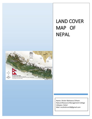
- 1. LAND COVER MAP OF NEPAL Name: Shishir Mahatara Chhetri Natural Resource Management College Udaypur, Katari Mail: mcshishirsm58@gmail.com
- 2. Study area This study covered the whole territory of Nepal which is located between latitudes 26°22'–30°27′N and longitudes 80°04'–88°12′E, with an area of 147,516 km2 . Politically the country is divided into seven federal states and 77 districts. The land cover in Nepal mainly includes different types of forests (broadleaf, needle leaf, mixed), croplands, shrub lands, grasslands, bare lands, Built Area, Clouds as well as permanent ice/snow (Wang, 2004; Uddin et. al., 2015). Nepal has five climatic zones, Tropical zone lie below 1000m, Subtropical zone 1000- 2000m), Temperate zone (2000-3000m), Subalpine zone (3000-4000m), Alpine zone (4000-5000m).
- 3. Land cover Map Land cover is the physical material at the surface of Earth. Land covers include Grassland, Trees, Bare ground, Water, flooded vegetation, Agricultural Crops, Built Area etc. Land use is the term used to describe the human use of land. It represents the economic and cultural activities (e.g., agricultural, residential, industrial, mining, and recreational uses) that are practiced at a given place. Land use differs from land cover in that some uses are not always physically obvious (e.g., land used for producing timber but not harvested for many years and forested land designated as wilderness will both appear as forest-covered, but they have different uses). Land use changes occur constantly and at many scales, and can have specific and cumulative effects on air and water quality, watershed function, generation of waste, extent and quality of wildlife habitat, climate, and human health.
- 4. Types of land Use categories and Description 1. Water Areas where water was predominantly present throughout the year; may not cover areas with sporadic or ephemeral water; contains little to no sparse vegetation, no rock outcrop nor built up features like docks; examples: rivers, ponds, lakes, oceans, flooded salt plains. 2. Trees Any significant clustering of tall (~15 feet or higher) dense vegetation, typically with a closed or dense canopy; examples: wooded vegetation, clusters of dense tall vegetation within savannas, plantations, swamp or mangroves (dense/tall vegetation with ephemeral water or canopy too thick to detect water underneath). 3. Flooded vegetation Areas of any type of vegetation with obvious intermixing of water throughout a majority of the year; seasonally flooded area that is a mix of grass/shrub/trees/bare ground; examples: flooded mangroves, emergent vegetation, rice paddies and other heavily irrigated and inundated agriculture. 4. Crops Human planted/plotted cereals, grasses, and crops not at tree height; examples: corn, wheat, soy, fallow plots of structured land. 5. Built Area Human made structures; major road and rail networks; large homogenous impervious surfaces including parking structures, office buildings and residential housing; examples: houses, dense villages / towns / cities, paved roads, asphalt. 6. Bare ground Areas of rock or soil with very sparse to no vegetation for the entire year; large areas of sand and deserts with no to little vegetation; examples: exposed rock or soil, desert and sand dunes, dry salt flats/pans, dried lake beds, mines. 7. Snow/Ice Large homogenous areas of permanent snow or ice, typically only in mountain areas or highest latitudes; examples: glaciers, permanent snowpack, snow fields. 8. Clouds No land cover information due to persistent cloud cover. 9. Rangeland Open areas covered in homogenous grasses with little to no taller vegetation; wild cereals and grasses with no obvious human plotting (i.e., not a plotted field examples: moderate to sparse cover of bushes, shrubs and tufts of grass, savannas with very sparse grasses, trees or other plants.
- 5. Application of land cover mapping Local and regional planning Disaster management Vulnerability and Risk Assessments Ecological management Monitoring the effects of climate change Wildlife management. Alternative landscape futures and conservation Environmental forecasting Environmental impact assessment Policy development Reference forest and land cover analysis. (2019). forest research and traning center. (Wang, 2004; Uddin et. al., 2015) http://nfgrcnepal.blogspot.com/2007/07/grassland-resources-in-nepal-by.html http://www.esri.com