
Recommended
More Related Content
Similar to Poverty point power_point_2016 (1)
Similar to Poverty point power_point_2016 (1) (8)
Recently uploaded
Recently uploaded (20)
Poverty point power_point_2016 (1)
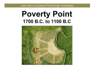
- 1. Poverty Point 1700 B.C. to 1100 B.C Learn about Louisiana’s Past through Archaeology
- 2. Poverty Point PicturebyHerbRoe Poverty Point at 1200 B.C.
- 3. Poverty Point people, landscape features and artifacts PaintingbyMartinPate Poverty Point
- 4. Timeline of Events 2000 to 800 B.C. Tutankhamun rules Egypt 1324 B.C. Poverty Point 1700-1100 B.C. Stonehenge last phase 2000 B.C. Shang Dynasty begins in China 1760 B.C. 2000 B.C. 1800 B.C. 1600 B.C. 1400 B.C. 1200 B.C. 1000 B.C. Poverty Point First Olympic Games 776 B.C. Corn in Mexico 1200 B.C.
- 5. Poverty Point hunter-gatherers PaintingsbyMartinPate Hunting wild game with atlatl Fishing with cast net and weights Poverty Point
- 6. Poverty Point earth mounds and ceremonies Building earth mounds People and ceremonies Poverty Point PaintingsbyMartinPate
- 7. CourtesyofFEMAandtheStateofLouisiana LiDAR map of Poverty Point Poverty Point Modern Road
- 8. Mound A, Poverty Point Poverty Point Photograph©JennyEllerbe
- 9. Mound B, Poverty Point Poverty Point Photograph©JennyEllerbe
- 10. Mound C, Poverty Point Poverty Point Photograph©JennyEllerbe
- 11. Mound E, Poverty Point Poverty Point Photograph©JennyEllerbe
- 12. Mound F, Poverty Point PhotographbyDianaGreenlee Poverty Point
- 13. C-shaped earth ridges, Poverty Point Poverty Point CourtesyofU.S.ArmyCorpsofEngineers CourtesyofFEMAandtheStateofLouisiana
- 14. C-shaped earth ridges, Poverty Point Poverty Point Photograph©JennyEllerbe
- 15. Plaza, Poverty Point Poverty PointPhotographbyAlishaWright Area where postholes were found
- 16. Poverty Point Photograph©JennyEllerbe One of the circles in plaza at Poverty Point Area where postholes were found
- 18. Stone and ore from Poverty Point Artifact photographs © Jenny Ellerbe Poverty Point MapbyDianaGreenlee Mill Creek Chert Tallahata Quartizite Catahoula Sandstone Galena Gray Northern Flint Steatite Pickwick Chert Hematite “Local” Citronelle Gravel
- 19. Atlatl Weight Hunting Technology Photograph by Diana Greenlee Poverty Point Photograph © Jenny Ellerbe Stone Point Weight Atlatl ArtworkbyPaulaMcIver
- 20. Groundstone gorgets Poverty Point Photograph © Jenny Ellerbe
- 21. Groundstone plummets Poverty Point Photograph © Jenny Ellerbe
- 22. Groundstone celts Poverty Point Photograph © Jenny Ellerbe
- 23. Red jasper owl pendants Poverty Point Photograph © Jenny Ellerbe
- 24. Red jasper beads Poverty Point Photograph © Jenny Ellerbe
- 25. Stone bowl Photograph © Jenny Ellerbe Poverty Point
- 26. Stone microliths Photograph © Jenny Ellerbe Poverty Point microdrills microblades
- 27. Poverty Point Objects (PPOs) Photographs © Jenny Ellerbe Poverty Point
- 28. Clay figures Photograph © Jenny Ellerbe Poverty Point
- 29. What we learned from Poverty Point Photograph©JennyEllerbe Poverty Point
- 30. Poverty Point named a World Heritage Site PovertyPointWorldHeritageSitePlaque,October11,2014 Poverty Point
- 31. Poverty Point 1700 B.C. to 1100 B.C This presentation is one in a series of modules about Louisiana archaeology. Each module has a PowerPoint presentation and associated student activities. The series is called “Learn about Louisiana’s Past through Archaeology.” This presentation is intended for educational use. Please use image credits where provided. Please visit the Division of Archaeology website for additional teaching materials and educational resources at: www.crt.la.gov/DiscoverArchaeology. Presented by: Louisiana Division of Archaeology Office of Cultural Development Department of Culture, Recreation and Tourism Office of the Lieutenant Governor Baton Rouge, Louisiana This project was made possible through the Governor's Office of Homeland Security and Emergency Preparedness (GOHSEP) and the Federal Emergency Management Agency (FEMA) as part of implementing the Louisiana Hazard Mitigation Grant Program for Hurricane Katrina recovery. © Louisiana Division of Archaeology 2016
Editor's Notes
- Title: Poverty Point 1700 B.C. to 1100 B.C. Image credit: Herb Roe
- Poverty Point – 1700 B.C. to 1100 B.C. This module introduces Poverty Point. The site is located in West Carroll Parish near the town of Epps. American Indians started living at the site around 1700 B.C., which makes it about 3700 years old. Archaeologists discovered that the site was in use for about 600 years. This is a picture of what the site might have looked like at 1200 B.C. At that time, Poverty Point had the largest earthworks in North America. Image credit: Herb Roe
- Poverty Point – 1700 B.C. to 1100 B.C. In this module, we’ll take a look at the people, landscape features, and artifacts from Poverty Point. You will learn what archaeologists have discovered, and what these discoveries tell us about this unique site. This is a painting of what everyday life might have been like for the people of Poverty Point. Image credit: Martin Pate
- Poverty Point – 1700 B.C. to 1100 B.C. First, let’s put Poverty Point in context of what was going on in the rest of the world. Here is a timeline from 2000 to 800 B.C.
- Poverty Point – 1700 B.C. to 1100 B.C. People The people who built Poverty Point relied on hunting, fishing, and gathering wild plants for their food. They did not raise any crops or animals for food. Archaeologists describe these people as “hunter-gatherers.” The people who built the site did not call it “Poverty Point.” We do not know what the Indians called the site because they did not have writing. The archaeologists who recorded the site named it after the historic plantation that was there in the early 1800s. These are paintings depicting Poverty Point people hunting and fishing for their food. Image credit: Martin Pate
- Poverty Point – 1700 B.C. to 1100 B.C. Archaeologists learned how the people built the site and some of what they did there. For example, the people who built the earth mounds used many basket loads of soil. Artifacts left behind showed that many people lived at the site. Some artifacts may have been for special purposes, like ceremonies. Here are two paintings illustrating life at Poverty Point. In the top picture we see people using basket loads of soil to build the earth mounds. The soil came from the ground surface near the mound that was being built. In the other picture we see how the people might have looked, and get an idea of the activities that took place at Poverty Point. Image credit: Martin Pate
- Poverty Point – 1700 B.C. to 1100 B.C. Landscape Large earth mounds are an important feature of Poverty Point. This is a LiDAR map of Poverty Point where you can easily see the mounds. Light detection and ranging, or LiDAR, can read and measure features on the surface of the earth. LiDAR uses light in the form of laser pulses to make a three-dimensional image of the earth’s surface. Experts can take these images from an aircraft or from a satellite. Poverty Point people built five mounds at the site. They are labeled A, B, C, E, and F. Mound D was built nearly 2000 years later. The earth mounds cover an area of about 350 acres. We’ll take a closer look at these earth mounds in the next few slides. Image credit: LiDAR data courtesy of FEMA and the state of Louisiana, distributed by “Atlas: The Louisiana Statewide GIS,” LSU CADGIS Research Laboratory, Baton Rouge, Louisiana
- Poverty Point – 1700 B.C. to 1100 B.C. Mound A is the largest mound at the site. It was built about 1300 B.C., which makes it one of the last mounds built at the site. Mound A measures 72 feet tall at the highest point, and 710 feet long by 660 feet wide at the base. This is as big as a six to seven story building. It took over 312,000 cubic yards of soil to build Mound A. The people of Poverty Point would have used about 15.5 million basket loads of dirt that weighed 50 pounds each to build this mound. People have different ideas about the shape of Mound A. What does it look like to you? This photograph is taken halfway up the mound. Notice the people in this picture. They are very small compared to the upper part of mound. That gives you an idea of the size of Mound A. Archaeologists sometimes use people as scales when photographing large objects. Image credits: Photograph – © Jenny Ellerbe LiDAR – LiDAR data courtesy of FEMA and the state of Louisiana, distributed by “Atlas: The Louisiana Statewide GIS,” LSU CADGIS Research Laboratory, Baton Rouge, Louisiana
- Poverty Point – 1700 B.C. to 1100 B.C. Mound B is the oldest mound at the site. Mound B is 180 feet in diameter at the base, and 20 feet tall. Radiocarbon dated samples indicated the mound was built around 1600 B.C. The Poverty Point people built the mound in seven construction phases. The floors of some of these construction phases had firepits, charcoal and postholes. This evidence indicates that activities did take place there. In at least three construction phases the top of the mound was flat. In the final construction phase, the mound top was made round, in the shape of a cone. Archaeologists used to think that Mound B was a burial mound because of its round, conical shape, but no evidence has been found in the mound to support this idea. Image credits: Photograph – © Jenny Ellerbe LiDAR – LiDAR data courtesy of FEMA and the state of Louisiana, distributed by “Atlas: The Louisiana Statewide GIS,” LSU CADGIS Research Laboratory, Baton Rouge, Louisiana
- Poverty Point – 1700 B.C. to 1100 B.C. Mound C is located in the plaza at Poverty Point. It is 260 feet long by 80 feet wide and about six feet tall. The mound was likely cone-shaped when it was built. It doesn’t look cone-shaped now, because of historic activities long after the Poverty Point people left. Horse-drawn wagons in the 1800s traveled on a dirt road that passed over Mound C. They wore a deep rut in the mound. Mound C has 16 surfaces or “floors” of different color and texture soil. Some of the floors have evidence that people lived on them, such as artifacts, pits and postholes. A thick cap of soil was put over the mound during the last construction phase. Archaeologists know this is a Poverty Point mound, but are not sure where it fits in the sequence of mound building at the site. Image credits: Photograph – © Jenny Ellerbe LiDAR – LiDAR data courtesy of FEMA and the state of Louisiana, distributed by “Atlas: The Louisiana Statewide GIS,” LSU CADGIS Research Laboratory, Baton Rouge, Louisiana
- Poverty Point – 1700 B.C. to 1100 B.C. Mound E is about 13 feet tall and 300 feet by 260 feet at its base. It was once larger, but historical farmers, who may not have realized that it was a mound, removed some of the dirt. The mound has a ramp on one corner, but archaeologists aren’t sure if Poverty Point people built the ramp or if later people did. Mound E was built in five stages, all with a flat-top. Archeologists think it was one of the earliest mounds built at the site, around the time of Mound B or just after. Image credits: Photograph – © Jenny Ellerbe LiDAR – LiDAR data courtesy of FEMA and the state of Louisiana, distributed by “Atlas: The Louisiana Statewide GIS,” LSU CADGIS Research Laboratory, Baton Rouge, Louisiana
- Poverty Point – 1700 B.C. to 1100 B.C. Mound F is the smallest mound at Poverty Point. It measures 5 feet tall, and 80 feet by 100 feet at the base. Radiocarbon dated samples indicated the mound was built around 1280 B.C. It was the last Poverty Point mound built at the site. Image credits: Photograph – Diana Greenlee LiDAR – LiDAR data courtesy of FEMA and the state of Louisiana, distributed by “Atlas: The Louisiana Statewide GIS,” LSU CADGIS Research Laboratory, Baton Rouge, Louisiana
- Poverty Point – 1700 B.C. to 1100 B.C. Archaeologists have been working at Poverty Point since 1913. That’s when the first excavations took place at the site. However, it wasn’t until 1953 that they knew about the C-shaped earth ridges. One of the archaeologists working at the site was looking at an aerial photograph and saw the ridges. The ridges are so large that they are not easy to see from the ground. The image on the left is an aerial photograph, and the image on the right is a LiDAR map of the site. Image credits: Aerial photograph – United States Army Corps of Engineers LiDAR – LiDAR data courtesy of FEMA and the state of Louisiana, distributed by “Atlas: The Louisiana Statewide GIS,” LSU CADGIS Research Laboratory, Baton Rouge, Louisiana
- Poverty Point – 1700 B.C. to 1100 B.C. Archaeologists recorded six ridges at Poverty Point. Here is a photograph of the ridges. You can just make them out in the mist. The ridges range in height from six feet to one foot. The area once was farmed, and before that, the ridges likely were taller. The outer ridge is over 6,500 feet long, and the inner ridge is about 4,100 feet long. Archaeologists discovered that the C-shaped earth ridges were where the Poverty Point people lived. Archaeologists know this because they found most of the artifacts and cooking features, like hearths and earth ovens, on the ridges. Image credit: © Jenny Ellerbe
- Poverty Point – 1700 B.C. to 1100 B.C. The C-shaped ridges curve around a large plaza. Archaeologists found only a few artifacts in this area of the site. But, they discovered that changes had taken place in the plaza through time. Poverty Point people sometimes added dirt to the area and leveled it out to make the area flat. What archaeologists did find in the plaza were large postholes that show where circles of poles once stood. This is a photograph of part of the plaza area, and a LiDAR image of the area. Archaeologists discovered the postholes in the south end of the plaza, shown in the map by a circle. Image credits: Photograph – Alisha Wright LiDAR – LiDAR data courtesy of FEMA and the state of Louisiana, distributed by “Atlas: The Louisiana Statewide GIS,” LSU CADGIS Research Laboratory, Baton Rouge, Louisiana
- Poverty Point – 1700 B.C. to 1100 B.C. Postholes were dug in the ground to support huge wooden posts. They were up to two feet in diameter. These wooden posts formed circles up to 213 feet across. At least 25 of these circles were in the plaza. In the picture, the ring of white barrels shows the diameter of one circle. The original wooden posts were closer together than the white barrels, and they were taller. Archaeologists have not yet discovered how these big circles of poles were used. Image credit: © Jenny Ellerbe
- Poverty Point – 1700 B.C. to 1100 B.C. Trade Poverty Point was part of a large trade network. The location of the site was perfect for long distance trade. Poverty Point people built the site on Macon Ridge. This ridge is high, which protects it against flooding from nearby water sources. Several rivers are near Macon Ridge. One of the largest is the Mississippi River. Smaller waterways, such as Bayou Maçon, lie very close to the site. Indians used rivers and bayous to travel, much like we use roads today. These waterways were perfect for transporting goods and people. Image credit: Martin Pate
- Poverty Point – 1700 B.C. to 1100 B.C. Archaeologists know that Poverty Point was part of a long-distance trade network because of the objects discovered at the site. The area around Poverty Point does not have stone. But, there were many stone artifacts found at the site. Archaeologists were able to trace the stone to other areas of the United States, such as Iowa and the Appalachian Mountains. Archaeologists are not certain whether people brought stone to Poverty Point, or if people from the site traveled long distances to get the stone. There were over 78 tons of stone brought to Poverty Point. Here is a map of the different sources of stone and ore from Poverty Point, and a few examples from the site. The closest source was “local” Citronelle gravel about 25-30 miles northwest of the site. The most distant source was in Iowa, 650 miles away! Galena, a lead ore, was from that area. Notice that many of the source locations are along waterways. Image credits: Photographs – © Jenny Ellerbe Map – Diana Greenlee
- Poverty Point – 1700 B.C. to 1100 B.C. Artifacts Poverty Point people hunted with stone points and lightweight spears. Archaeologists discovered many stone points at Poverty Point. On the left are a few examples from the site. Poverty Point people attached stone points to long, slender pieces of wood to make spears. Sometimes the spears were thrown with the atlatl. Atlatls were made of wood. They increased the throwing power and distance of the spear. The people at Poverty Point used groundstone to make atlatl weights. The weights provided balance for the atlatl. On the right is a drawing of an atlatl, and an enlarged view of an atlatl weight. Image credits: Stone points – © Jenny Ellerbe Atlatl weight – Diana Greenlee Atlatl – Paula McIver
- Poverty Point – 1700 B.C. to 1100 B.C. Archaeologists found many groundstone artifacts at Poverty Point. The people shaped and ground the stone using other stones and water or sand. There were decorations on some of the ground stone. Archaeologists found flat, oblong stone artifacts called gorgets. Poverty Point people might have used them as personal art worn around the neck, like jewelry. Here are some examples of gorgets found at Poverty Point. The close up image shows designs found on one item. Image credit: © Jenny Ellerbe
- Poverty Point – 1700 B.C. to 1100 B.C. Archaeologists found groundstone plummets at Poverty Point. Indians used plummets as weights, likely on fishing line or cast nets. Image credit: © Jenny Ellerbe
- Poverty Point – 1700 B.C. to 1100 B.C. Archaeologists discovered groundstone celts at Poverty Point. A celt is a kind of tool, like an axe. They were used for chopping or shaping wood. Image credit: © Jenny Ellerbe
- Poverty Point – 1700 B.C. to 1100 B.C. Poverty Point people carved owl pendants from red jasper. Red jasper is a stone that Indians used to shape into different objects. Each piece has a hole in the back. It could have been worn as a necklace or decoration. You can see from the scale that these artifacts are small. Image credit: © Jenny Ellerbe
- Poverty Point – 1700 B.C. to 1100 B.C. Poverty Point people made beads out of stone. Here are a few examples of beads made from red jasper. Indians used stone drills to make the holes. They might have worn the beads around the neck, like jewelry. Image credit: ©Jenny Ellerbe
- Poverty Point – 1700 B.C. to 1100 B.C. In Louisiana, ceramic pottery was just beginning to be made at the time of Poverty Point. Archaeologists did not find much of it at the site. Poverty Point people used more stone bowls to cook and store food than pottery containers. The stone bowls were brought from northern Georgia or Alabama. They are made of steatite, a stone that is very soft and easy to carve. Here is an example of a steatite stone bowl. Image credit: © Jenny Ellerbe
- Poverty Point – 1700 B.C. to 1100 B.C. Archaeologists discovered small stone tools called microliths. “Micro” means small and “lith” means stone. In this photograph we see microliths for drilling and for cutting or scraping. Microdrills made holes in the beads and gorgets we saw earlier. Microblades have sharp edges and were multipurpose tools. Image credit: © Jenny Ellerbe
- Poverty Point – 1700 B.C. to 1100 B.C. Among the most numerous artifacts at Poverty Point were hard clay objects. Archaeologists call them Poverty Point Objects, or PPOs for short. Poverty Point people used them for cooking. They made PPOs from local clay and shaped them into a variety of designs. Here are a few examples of the shapes and styles. After the clay balls were hardened in a fire, they could be used like charcoal briquettes. They were placed in a shallow hole or earth oven, and a fire was built on top. After the flames died down, food was wrapped in leaves and put on the heated PPOs and covered with dirt. The heat from the PPOs cooked the food. Changing the number of PPOs was a way to control the temperature of food when cooking. Image credit: © Jenny Ellerbe
- Poverty Point – 1700 B.C. to 1100 B.C. Poverty Point people also made small clay figures. Here is a photograph of some of the human figures found at the site. The heads are removed or missing from many of these figures. Archaeologists are not sure how the people used these figures, but they might have been for special purposes, like ceremonies. Image credit: © Jenny Ellerbe
- Poverty Point – 1700 B.C. to 1100 B.C. Poverty Point held important information about life in prehistoric Louisiana. Archaeologists learned that not all people who relied on wild food needed to move around regularly. Poverty Point people were hunter-gatherers, but remained in one place all year round. The large size of Poverty Point was very unusual for a hunter-gatherer society. Archaeologists previously thought that hunter-gatherers had no need to build large sites. In fact, archaeologists thought that large sites were a sign of a society that grew much of their food. Yet, Poverty Point people were not farmers. The area around this site offered more wild food and other natural resources than the people needed to survive. As a matter of fact, the area supported large numbers of people throughout the year. The long-distance travel and trade was another important thing about Poverty Point. People and goods traveled quite far to reach Poverty Point. There is no other site in the world designed like Poverty Point. It was nearly 2000 years after Poverty Point before people in North America built a larger mound site. Image credit: © Jenny Ellerbe
- Poverty Point – 1700 B.C. to 1100 B.C. Poverty Point became a World Heritage site on June 22, 2014. This is a photograph of the World Heritage plaque. Only 23 sites in the U.S. are on the World Heritage Site list. Some sites you may recognize on the list are the Grand Canyon in Colorado (a natural site), Monticello in Virginia, (the home of Thomas Jefferson), the Pyramids of Giza (Egypt), and Stonehenge (England). The Poverty Point World Heritage Site is open to the public. Many artifacts discovered at the site are on display at the site’s museum. You can also tour the mounds. There are regular events scheduled at the site, such as flint knapping workshops and volunteer days for archaeology. You can find out more about this World Heritage Site at http://whc.unesco.org/en/list/1435. If you’d like to know more about this unique site, visit www.povertypoint.us, as well as the interactive website exhibit at http://www.crt.la.gov/DiscoverArchaeology, KnowLA.org at http://www.knowla.org/entry/540, and the Office of State Parks website at http://www.crt.state.la.us/louisiana-state-parks/historic-sites/poverty-point-state-historic-site/index. Image credit: Louisiana Office of Culture, Recreation and Tourism
- Credits