1. Figure 1: Coastal Coastlines of Penang Island
1
Coastal Erosion In Batu Ferringhi Coastline
(Possible reasons of the coastline erosion and mitigation measures)
Nalinii Ravichandran
Coastal Engineering
Department Of Civil Engineering
Universiti Teknologi PETRONAS
Tronoh,Perak,Malaysia.
naliniiravichandran@gmail.com
I. ABSTRACT
Rapid development in urban areas like Penang is something very common but it leads to some other
problems like coastal erosion . This problem even become worst due to some nature causes like tsunami
and incease in sea water level globally.Mitigation measures like planting dune vegetation,building jetty and
coastal structures,planting more mangroves trees and repair the remaining coastal strucutures also discussed
in this paper.The main objective of this study is to investigate possible cause of the beach erosion in Batu
Ferringhi coastline and mitigation measures that can be taken in order to solve the erosion in Batu Ferringhi
Coastline.As a overall conclusion,this study focusses on the erosion problem faced by Batu Ferringi
coastlines.
II. INTRODUCTION
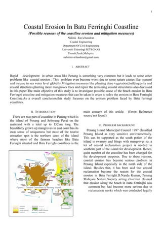
There are two part of coastline in Penang which is
the island of Penang and Seberang Perai on the
mainland with a total up to 152km long. The
beautifully grown up mangroves in east coast has its
own sense of uniqueness but most of the tourist
attraction spot is the northern coast of the island
where most of the famous beaches like Batu
Feringhi situated and Batu Ferrighi coastlines is the
main concern of this article. (Error: Reference
source not found)
III. PROBLEM BACKGROUND
Penang Island Municipal Council 1987 classified
Penang Island as very sensitive environmentally.
This can be supported as the south potion of the
island is swampy and fringy with mangroves so, a
lot of coastal reclamation project is needed in
southern part of the island for development. Hence,
quite number of the coastline has been changed for
the development purposes. Due to these reasons,
coastal erosion has become serious problem in
Penang Island especially in the north side of the
island. Besides that, it has been said that coastal
reclamation become the reason for the coastal
erosion in Batu Ferrighi.D.Nanda Kumar, Penang
Malaysia Nature Society acting chairman claimed
that erosion along the beach in Batu Ferringhi was
common but had become more serious due to
reclamation works which was conducted legally
2. Figure 2: Proposed coastal reclamation in Penang Island
2
and also illegally nearby Tanjung Bungah Beach.
(Error: Reference source not found)
IV. OBJECTIVES
By understanding coastal processes in general and
erosion along the shore in Batu Ferigghi as
particular the cause of the erosion problem can be
determined.
The objectives of this study are:
• To critically analyse the reason behind the coastal
erosion in Batu Ferringhi coastlines.
• To suggest suitable engineering solution for the
coastal erosion in Batu Ferringhi coastline.
V. SCOPE OF PAPER
The primary scope of this paper is to discuss the
coastal erosion problem in Batu Ferringhi and the
reason behind the problems. Besides that, the
recommendation and solution for the problem will
also be discussed in this journal.
VI. LITERATURE REVIEW
A. Coastal Process and development in Penang
Island
Penang has semidiurnal tides with spring tide
range of 1.9m.As general, the winds experienced by
Penang is gentle. The speed current of the wave can
reach up to 0.4m/s with wave height of 3.75 m
during monsoon. Apart from that, the swells which
formed in Andaman Sea frequently arrive along the
coastline of Gurney Drive. Besides that, the huge
waves expected around June when the northern coast
directly receive the wave but this waves get
refracted around the northwest coast of the
mangrove coast in Balik Pulau.(Error: Reference
source not found)
B. Erosion Problem at Penang Coastlines
Erosion problem at Penang coastlines is
something very common and been debated in many
places. It is considered a very huge problem and
one of the main reason for this is land
reclamation.Many coastlines in Penang Island had
been modified except for rocky coasts which quite
hard to do reclamation.National Coastal Erosion
Study reported that nearly 30 per cent of the
coastlines in Peninsular are eroding and 30 per cent
of it are undefined. Penang Coastline has become
one of the main contributor to the percentages. The
causes of erosion are many no matter naturally or
due to human activities.(Error: Reference source not
found)
3. Figure 3: Coastal erosion at Batu Ferringhi Coastline
Figure 4: anti erosion measures
3
C. Mitigations at Penang Island coastlines
Penang Government has been working on several
mitigation method which can help to reduce the
erosion the all the beaches in Penang coastlines.
One of it is identifying coastlines that vulnerable to
erosion and plant the suitable mangrove species
based on the soil type. Other than that, breakwater
also used as one of mitigation method where it was
placed at Tajung Tokong so reduce the land
reclamation effect on coastlines but it is not that
effective to reduce the erosion.
Apart from that, anti-erosion measures taken by
putting large boulders along Batu Ferrighi
coastlines but it was not properly arranged or in
other word not effective to function as beach anti
erosion. (Figure 4)
D. Effects of Land Reclamation
The rapid development in urban areas like Penang
causes more lands are needed for reclamation
project as the land is not enough for the
development projects. So, land reclamation has
become as become best option for them.One of the
most significant land reclamation project is Tanjung
Tokong reclamation project. Research shows that
waves coming from there was more affected
compared to incoming wave from north and east of
land reclamation. If we take a look at the map, the
west part of Tanjung Tokong consist of Teluk
Bahang and Batu Ferringhi coastlines. (Error:
Reference source not found)
Even though, there were no obvious differences
involving the sediment transport along the coastal
after the project but the effects on coastal increased
erosion for the waves coming from the west and it
also increased the accumulation of waves coming
from the east for some particular coastlines. As a
conclusion, it is true that Tanjung Tokong land
reclamation project do have impact on the wave
transformation, changes in coastal area and
sediment transport.
4. Figure 5: Polluted water from sewage treatment plant flowing into
Batu Ferringhi beach.
4
E. Mangrove as the natural shield to coastlines
Mangrove known as natural shield for coastlines
for centuries ago. Mangroves damped and absorb
the vigorous wave energy, reduce the sedimentation
and erosion effects. Recently, these mangrove
swamps deplete drastically and it is due to several
reasons like pollution no matter because of heavy
metal from industry and some other reasons like
land reclamation.Other than that, Asian region are
highly prone to heavy metal contamination.
VII. PROBLEM ANALYSIS
Erosion at coastline of Batu Ferringhi Penang is
something that is very common and it had been a
very serious problem that have been discussed in all
level. The erosion problem can be analysed into two
different category which are:
1) Erosion due to human error
2) Erosion which subject to natural cause
These each category contribute to specific reasons
which will be discussed below.
EROSION DUE TO HUMAN ERROR
A. Coastline Reclamation in Tanjung Bungah and
Tanjung Tokong
Penang has become one of the state that is
developing fast but due to shortage of land, the
authorities or the developer tend to do land
reclamation to get their desired project done. The
development project has become more prioritized
compared to the sensitive coastlines.
It has been said the erosion in Batu Ferringhi
become more serious due to legal illegal coastline
reclamations along Tanjung Bungah coastlines.
Besides that, it also had been said that the erosion at
Batu Ferringhi coastlines is also effected by land
reclamation project at Tanjung Tokong which is not
that far from there. This is because of the land
reclamation project developer does not take
consideration of the effect on other coastlines of
Penang Island especially like Batu Ferringhi. As an
addition, the wind that blows from Andaman Sea
drifts the sands from Batu Ferrighi to other place.
Previously, it was protected by Tanjung Bungah
coastlines based on the shape but as the coastlines
now in different shape it worsen the erosion.
B. Coastline Pollution
On 4th
of March 2014, Astro Awani release a
news about pollution in Batu Ferringi where the
beach was polluted a very dangerous. (Figure 5)It
was found that it contained traces of the Escherichia
coli (E.coli).Other than that, Batu Ferringhi has
been known one of the most polluted beach in
Malaysia. Besides that, Batu Ferrighi coastline also
polluted because of food premises, laundry, and car
wash activities. There is a reason why pollution can
lead to beach erosion. The bacteria from the
pollution can degrade the dune vegetation which
has become natural coastline protector. Thus, the
coastline erosion become worst. (Figure 6)
C. Uncontrolled Exploitation of mangroves
It has been proven that mangroves has become
one of the natural protection towards coastlines but
5. Figure 6: Degraded dune vegetation at Batu Ferringi beach
Figure 7: The changes on the land geography due to reclamation
5
due to exploitation and development along
coastlines had caused the depletion of the
mangroves jungles.Based on several research, wind
usually erode the coastlines but it shows that
mangrove filter some wind that usually approach
the coastline thus the erosion problem can be
avoided. Many fishermen in Penang were saved
from death and serious damage to their homes
when the tsunami waves hit several coastlines on
26th
of December 2004.This is because the
mangrove swamps, especially along Pulau Betong,
Balik Pulau, Batu Kawan and Kuala Sungai Pinang
coastlines which shielded them from the giant
waves.
D. Illegal Reclamation
Some reclamation project that has been done does
not approved by any authorities thus risk
assessment on coastline is not conducted before the
project was carried on. This causes serious problem
not only the original coastline but it also effected
the nearby coastlines. The illegal reclamation at
Tanjung Bungah contributed as one of the reason
for the coastal erosion in Batu Ferringhi
coastlines.The illegal reclamation which changes
some of the natural flow of the wind and also
sedimentation causes more sand are been drain
away which lead to erosion at Batu Ferrighi
coastlines. (Figure 7)
EROSION DUE TO NATURAL CAUSE
E. Tsunami wave attack at coastline
2004 “Boxing Day”,Tsunami 2004 not only
effected many emotionally but it also cause
considerable damage to the coastline especially
Batu Ferrighi coastline. The tsunami waves eroded
the sand coast, entered the river mouth and also
travelled quite distance towards inland. The energy
from the tsunami wave is large enough to carry and
erode the sandy coast of Batu Ferrighi.
F. Increase in sea water level globally
Since decades, scientist has been observing the
increase in water level along coastlines in every part
of the world. Penang coastlines also affected due to
this problem. The increase in sea water level can
cause the tidal and wave height to be higher and
erode the beaches more correspondingly.(Figure 8)
6. Figure 8: Scarped beach at northern of Batu Ferringhi
6
VIII.ENGINEERING SOLUTIONS
Engineering solution to protect the coastlines
really plays its own role no matter in term of
reducing the effect or avoid the problem
completely.
A. Coastal dune vegetation
Most of the dunes are backed by vegetated sand
ridges that known as dunes which built up by dry
beach sand as it blown inland and get trapped by
plants and other obstructions. When the sand
accumulates, the dunes become higher and bigger.
These plants plays vital role acting as windbreaker
by trapping the deposited sand particles.
As example, we can plant coastal she-oaks
(Casuarina equisetifolia) on frontal sand which can
reveal the real condition of the beach always. Other
trees of this zone are Pandanus species, coastal
banksia(Banksia integrifolia ) wattles(Acacia
spp.),beach almond(Terminalia spp.) and beach
calophyllum(Calophyllum inophyllum). It had been
surveyed that sand usually accumulate around these
vegetation but if there are absent then the coastline
is eroding. This can help us to always to trace any
kind of erosion occurring in any particular
coastlines. Besides that, the ability of dune
vegetation to trap sand can help to reduce the
coastline erosion especially in Batu Ferrighi.
B. Build coastal structures
There are three main types of coastal
strcutures.The first category lies under revetments,
groins and seawalls which not that suitable for
tourist attraction spot like Batu Ferrighi. The second
category is in the form of jetty to prevent the
siltation of river mouths. The second option which
building jetty can be really a good option but it can
protect the coastlines from serious erosion due to
winds especially for the winds that reached the
beach from the side.
The third type of coastal structure is breakwaters.
The breakwater can also be useful in term of
protection from Tsunami waves. Research shows
that, when the Tsunami waves attacked the
coastlines on Penang, the beaches with coastal
structures shows less erosion problem compared to
the beaches without coastal strcutures.It is clearly
saying that coastal structures plays important role in
protecting the coastlines.
C. Plant more mangrove trees
Mangrove planting campaign had been started
since long time ago but it is still not enough.Teluk
Bahang reserve jungle is the only place where the
mangrove trees has been reserved properly whereas
mangrove jungle at other coastlines like Sungai
Burung, Pantai Acheh and Balik Pulau had never to
come authority attention thus, these more mangrove
swamps has been removed for reclamation
developments. As a solution, it would best if the
remaining mangrove swamps reserved for future
and more mangrove trees planted along the the
Teluk Bahang coastlines to reduce the erosion and
as protection especially for Batu Ferringhi coastline.
D. Repair the remaining coastal strcutures
There are some coastal structures can be repaired.
If the boulders arranged properly, most probably it
7. 7
can reduce the erosion along the beach. On the other
hand, repairing can reduce the mitigation cost
sometimes.
IX. RESULT AND DISCUSSION
Based on the study conducted, it is clear that there
are several possible reason for the coastal erosion at
Batu Ferringhi Beach. This includes due to human
or natural cause.
Land reclamation, illegal land reclamation, beach
pollution and uncontrolled exploitation of
mangroves take the lead as main cause. In the
natural side, tsunami waves and increase in sea
water level contribute as natural cause of coastal
erosion at Batu Ferrighi.
These problems can be solved if effective
mitigation methods are taken like planting coastal
dune vegetation and more mangrove trees.
Breakwater is also one of the possible solution to
this problem even though, repairing the remaining
coastal structures can a part of the solution.
X. CONCLUSION AND RECOMMENDATION
The aim of this study were achieved in term of
identifying the possible reasons for coastal erosion
in Penang coastlines and proposing engineering
solution for the problem. Other than that, mitigation
method should be taken to reduce erosion and to
protect the coastlines.
As a recombination, it would be better if this studies
is continued with some engineering analysis in
future so that, it can be solid reason to proof the
validity of this study.
XI. REFERENCES
[1] Y. H. B. H. C. I. Teh Tiong Sa (National University
of Singapore), "Malaysia-Penang," p. 50, 2012.
[2] S. Ramly, "Impact on the coastal areas of the
Tanjung Tokong Land Reclamation
Project, Penang, Malaysia," p. 76, 2008.
[3] Z. Ghaderi, A. P. Mat Som, and J. C. Henderson,
"Tourism crises and island destinations:
Experiences in Penang, Malaysia," Tourism
Management Perspectives, vol. 2-3, pp. 79-84,
2012.
[4] "<Changes-in-the-macrobenthos-community-of-
a-sand-flat-after-erosion_1995_Estuarine-
Coastal-and-Shelf-Science.pdf>."
[5] E. C. F. a. T. T. S. Btnn, "Current State of the
Coastal Zone in Malaysia," Malaysian Journal of
Tropical Geography, vol. 2, 2005.
[6] S. Rahman. 26 Feb 2015). Malaysia moves
against coastal erosion crisis.
[7] N. M. Nadzir, M. Ibrahim, and M. Mansor,
"Impacts of Coastal Reclamation to the Quality
of Life: Tanjung Tokong Community, Penang,"
Procedia - Social and Behavioral Sciences, vol.
153, pp. 159-168, 2014.
[8] "<Megacity-development-managing-impacts-
on-marine-environments_2001_Ocean-Coastal-
Management.pdf>."
[9] S. Shamsuddin, A. B. Sulaiman, and R. C. Amat,
"Urban Landscape Factors That Influenced the
Character of George Town, Penang Unesco
World Heritage Site," Procedia - Social and
Behavioral Sciences, vol. 50, pp. 238-253, 2012.
[10] S. Sandilyan and K. Kathiresan, "Decline of
mangroves – A threat of heavy metal poisoning
in Asia," Ocean & Coastal Management, vol.
102, pp. 161-168, 2014.
[11] H. Yanagisawa, S. Koshimura, K. Goto, T. Miyagi,
F. Imamura, A. Ruangrassamee, et al., "The
reduction effects of mangrove forest on a
tsunami based on field surveys at Pakarang
Cape, Thailand and numerical analysis,"
Estuarine, Coastal and Shelf Science, vol. 81, pp.
27-37, 2009.
[12] "Land Reclamation In Tanjung Bungah," ed,
2014.
[13] A. Awani, 4 March 2014 2014.
[14] Q. G. D. o. e. a. h. protection), "Coastal Dunes,"
7th February 2012 2012.
[15] F. W. Colbourne, "
Tsunami Impact on the West Coast of Penang Island,
Malaysia," Earth Science DepartmentEmporia
8. 8
State UniversityEmporia, Kansas, Research
Project ReportMay, 2005.
[16] L. Y. Kwong, "Some Issues of Coastal Land
Reclamation in Penang,", Ed., ed, 2015.
[17] R. K. Zahari, R. N. R. Ariffin, M. Z. Asmawi, and
A. N. Ibrahim, "Impacts of the 2004 Tsunami:
Preparedness of the Malaysian Coastal
Communities," Procedia - Social and Behavioral
Sciences, vol. 105, pp. 569-576, 2013.