Filio case study
•Download as PPTX, PDF•
0 likes•8 views

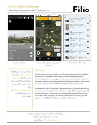
WRA Engineering uses environmental scientists to conduct regulatory assessments and ensure native vegetation meets permit criteria in a Florida wetlands construction zone. Scientists take over 1,200 quarterly photos across 80 locations, facing north, south, east, and west. Filios' mobile app automatically assigns location and direction metadata, and its web platform allows sorting and reviewing photos. Filios updated its platform within a week to enable sorting by description, saving WRA 16+ hours of work per project and reducing costs by an estimated 50%.

Recommended
More Related Content
Recently uploaded
Recently uploaded (20)
Featured
Featured (20)
Filio case study
- 1. WRAEngineering,a Filiocustomer,employsa team ofenvironmentalscientiststo executeregulatory assessmentsforlanddevelopment.Theseevaluationsareoftenconductedas mitigationfor constructionprojects,as environmentalprotocolsrequireconstructioncompaniestorestorea certain percentageofvegetation.Onesuchprojectensuresthenativevegetationinhabitinga Floridawetlands constructionzonemeetsthecriteriaestablishedinthedevelopment’sconstructionpermit. Trackingthezone’splantliferequirestaking aphotographicinventoryofallvegetationwithinthearea ona quarterlybasis.Inthiscase,an environmentalscientistis responsiblefortakingphotographsat 80 differentphotolocations– andphotosfacingnorth,south,east,andwestmustbecapturedat each location.Whenphotosarecompiledat theendoftheyear,thescientistmust inventory,order,and reportonmorethan1,200 photosofplants–manyofwhichlookthesame! The Project Faster, Simpler, and Smarter Photo LogManagement for aCivilEngineering Firm WRA Engineeringteamedup withFiliotoreducetimeand resourcesneededtocreate photologs.Filiodeployedan appupgradeinunderseven days tomaximizeuserexperience withoutlosingtimeon theproject. AnnotateSitePhotos AutomaticallyCaptureCoordinatesand Direction Sort andReview PhotoLogs TheSmartWaytoManageVisualAssetsforProjects Reach outtoregisterforafreetrial: www.filio.io • contact@filio.io
- 2. UsingFilio,WRA’senvironmentalscientiststakephotosandvideosusingthecamera builtintotheFiliosmartphone app.Themobileappautomaticallyassigns a geolocationandmeasuresthedirectionofeachphotowhileallowing userstoaddvoicenotesandmarkuptheimages.SinceFilioinstantaneouslysyncsphotostothecloud,team membersintheofficecanreviewinformationvia a correspondingwebplatformas fieldcrewscollectonsiteproject data.Inthewebplatform,userscanorganizephotosintodedicatedprojects,making images standardizedand searchableforsubsequentediting,filtering,reporting,andpresentation. WhenWRAfirstdeployedFiliointheirwetlandsmonitoringproject,theappenabledrichdata collectioninthefield, buttheusersstillfacedanenormouschallenge.Theprojectincludedmorethan1,200 photosofsimilartreesand landscapes,making itextremelydifficultfortheWRAteamtodifferentiatebetweenimages withintheproject.Filio originallysortedimagesbydate,whichwassufficientforsmallerphotocollections,butdidnotsufficeforthewetlands survey’senormousdocumentlibrary. FilioandWRAdiscussedtheissueonaconferencecall andidentifiedthesolution:thewebplatformneededa sort-by- descriptionfeature.Withinsevendays,theFilioteamupdatedtheprogramtoenabledocumentsortingusinganyfield: notonlydate,butalso name,description,andgeolocation. Going the ExtraMile Filio’s Solution WRA wasusing threedifferent softwarestoreach thesameresultFilio achieveson itsown. “My favoritethingis theconvenienceand timesavingfactor. I useFilio everytime I’min thefield.” – WRA scientist WRAscientistscan hoverovera thumbnailofanyimageinthephotologtoviewthename,accompanyingdescription,andcoordinates.Withthis capabilityat theirfingertips,theWRAteamcan easilyidentifycriticalinformationabouteachphoto(suchaswhichcardinaldirectionitfaces).Thefeature turneda multi-daysortingprocessintoa simpleclickandisnowavailableto Filiocustomerseverywhere. Thenew photosortingfeaturesavedWRA 16+ hoursof labortime forthe wetlandsmonitoringprojectalone Using Filioreducedcostsbilledto the photolog projectby anestimated50% TheFilioupgradetookunder oneweek, enablingan enhanceduserexperience withoutlosingtime onthe project PriortoimplementingFilio,a WRAscientistwouldtake a pictureorvideousinga camera rollapp,manuallymarkGPSlocationsonindividualphotosin a separateglobalpositioningsystem(GPS),andfinallycreatea map ina geographicinformationsystem(GIS).Filioachievesallthreeofthesefunctions, streamliningWRA’sphotomanagementprocessfromthreesoftwarestoone. StartYourOwnGreatExperience • www.filio.io • contact@filio.io