
Recommended
Recommended
More Related Content
What's hot
Viewers also liked
Viewers also liked (20)
Atlanta's electric car routes, 1928
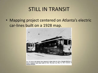
- 1. STILL IN TRANSIT Mapping project centered on Atlanta’s electric car-lines built on a 1928 map.
- 2. MAPPING PROJECT Tracing the routes of electric cars on 50 maps of Atlanta in 1928. Each route comprises line segments without a break: over 700 such lines. Unearthing historical sources for data, anecdotes, photographs. Hyper-linking routes and attaching information to the maps.
- 4. Attaching narrative to place
- 8. Scanned maps of Atlanta 1928
- 10. Before a curve, intersection or deviation, the line is ended with a double-click.
- 14. No. 19?
- 15. Historical route map of June 1924
- 18. Meta-data
- 20. The data currently includes ownership details, route changes, historical information, photographs as well as anecdotes.
- 22. Challenge: Presenting dense data
- 23. Using mapping in pedagogy Feminist action: Immediacy of marking sites of harassment/violence; sense of ‘action’. Acquaintance with new place: Understanding, exploring historical records/changes. Combining data and visual to present layered account of space, place and information. Mapping genealogies, relationships, structures? This is an experiment!
Editor's Notes
- http://www.ingentaconnect.com//content/brill/rip/1999/00000029/00000001/art00003: Thomas R. Flynn (1999). The Philosopher-Historian as Cartographer: Mapping History with Michel Foucault.Research in Phenomenology 29 (1):31-50.