Download as PDF, PPTX


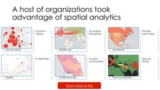


The document discusses the role of geospatial technology in the COVID-19 response, highlighting how various organizations utilized spatial analytics for tracking and analysis. It addresses challenges faced such as data availability and policy barriers, while proposing a vision for a next-generation geospatial enterprise landscape through partnerships and integrated policies. Emphasis is placed on the importance of governance, real-time data processing, and collaboration in building a robust geospatial knowledge infrastructure.


![5G Explained! A High Level Overview [Introduction]](https://cdn.slidesharecdn.com/ss_thumbnails/5gexplainedahighleveloverview-260119165306-cc137a3e-thumbnail.jpg?width=640&height=640&fit=bounds)


