Giri in auto
•
0 likes•336 views

Tutto quello che c'è da vedere nei dintorni dell'altopiano Dolomiti Paganella in Trentino: musei, laghi, castelli, attrazioni.

Recommended
More Related Content
Similar to Giri in auto
Similar to Giri in auto (20)
More from ApT Dolomiti Paganella
More from ApT Dolomiti Paganella (20)
Giri in auto
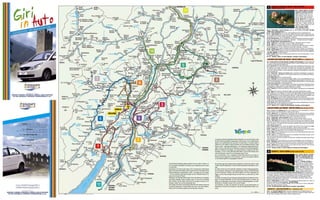
- 1. CASTELLI DI STENICO E TOBLINO - RIVA DEL GARDA 1 (andata e ritorno km 127) km 0 - Andalo, Molveno, Fai della Paganella, Cavedago e Spormag- giore. Da Molveno (864 m) si pro- segue lungo la S.S. 421 per S. Lo- renzo in Banale (758 m) e Dorsino (635 m), dove si gira a destra per km 18 – Stenico (667 m), centro del Banale noto per il suo castello me- dioevale. All’interno del castello, visi- tabile tutto: il Salone romanico del giudizio, il Salone Clesiano e la Torre della Fame con le prigioni. (Info: +39 0465 771004). Si prosegue a destra verso km 21 - Ponte Arche - Terme di Comano (400 m), nota località termale (Info: +39 0465 702626; www.visitacomano.to) e il km 33 – Passo del Ballino (763 m) con i resti palafitticoli di Fiavè, proseguendo per il km 37 – Lago di Tenno (570 m) e l’omonimo castello. Attraverso uliveti e vigneti (zona nota per produzione del Vin Santo e della carne salada), si giunge al bivio per la cascata del Varone che precipita per m 87 in un orrido suggestivo. Si arriva a km 49 – Riva del Garda (73 m), cittadina posta sull’estremità settentrionale del lago di Garda. Da visitare: la Rocca, costruzione del XII sec., il Bastione… Possibili escursioni in battello. (Info: +39 0464 554444, www.gardatrentino.it) km 53 – Torbole (85 m) patria della vela e del windsurf. Deviazione sulla S.S. 240 per km 55 – Nago (222 m) sulla statale, a sinistra le «Marmitte dei Giganti» km 62 – Arco (91 m) stazione climatica e di cura dominata dai ruderi dell’omonimo castello. Ci si immette sulla S.S. 45 bis e, attraverso la zona delle «marocche», si arriva a km 78 – Sarche (250 m) dove si prosegue a destra in direzione Trento per 2 km trovando il km 80 – Lago di Toblino (250 m) con omonimo castello situato su stretta penisola, circonda- ta su tre lati dall’acqua: suggestivo maniero, parzialmente trasformato in ristorante (Info: tel. +39 0461 864036). Si ritorna indietro a km 82 – Sarche (250 m) dove si imbocca sulla destra la S.S. 237 per Ponte Arche, S. Loren- zo in Banale arrivando a km 127 – Molveno, Andalo, Fai della Paganella, Cavedago e Spormaggiore. SCHLÖSSER VON STENICO UND TOBLINO - RIVA DEL GARDA Hin- u. Rückfahrt km 127 km 0 - Andalo, Molveno, Fai della Paganella, Cavedago und Spormaggiore. Von der Staatsstraße 421, die am Ostufer des Molvenosees entlang führt, durch S. Lorenzo in Banale (758 m), nach Dor- sino (635 m) zweigt rechts eine Straße nach km 18 - Stenico (667 m). Dieser Ort des Banale ist dank seiner mittelalterlichen Burg berühmt, einer der ältesten in der Region. Sehenswert im Schloss sind der leichte aber berüchtigte Turm (er wurde als Kerker benutzt), den man als »Torre della Fame« (Hungerturm) bezeichnet, der roma- nische Saal »Sala del Giudizio« und der Clesio-Saal. Ganzjährig zur Besichtigung frei. Man folgt rechts der Straße nach km 21 - Ponte Arche - Thermen von Comano (400 m), berühmtes Thermalzentrum, das ganz be- sonders auf Hautkuren spezialisiert ist. Hier zweigt die Straße durch Fiavé (Reste einer Pfahlbau- tensiedlung) steigend zum km 33 - Ballino-Pass (763 m) und weiter nach dem km 37 - Tennosee (570 m) und dem gleichnamigen Schloss. Auf der Panoramastraße, die zum Gardasee hinabführt, zwischen Olivenhainen und Weingelände (dieses Gebiet ist für den Wein »Vino Santo« und das Pökelfleisch »Carne salada« bekannt) liegt die Ortschaft Varone, mit den berühmten 87 Meter hohen Wasserfällen, und dann erreicht man km 49 - Riva del Garda (73 m), altes Städtchen am Nordufer des Gardasees. Sehenswert sind die massive Burg »La Rocca« aus dem 12. Jahrhundert und die »Bastione«, eine venezianische Fes- tung. Möglichkeit zu Bootsfahrten. Die Straße verlässt Riva und erreicht km 53 - Torbole (85 m) Heimat des Windsurfs und des Segelns. Abzweigung auf der Staatsstraße 240 nach km 55 - Nago (222 m) links die »Marmitte dei Giganti« gennanten Gletschermühlen und nach km 62 - Arco (91 m). Die Ortschaft, am Fuß der Ruine der gleichnamigen Burg (sie steht Besuchern offen; beachtenswert ist der Wachturm), ist dank seines milden Klimas als Luftkurort bekannt. Die Staatsstraße 45 bis führt nun durch das Gebiet der »Marocche«, riesiger Felsblöcke aus Kalkstein, nach Ton km 78 - Sarche (250 m). Von hier rechts in Richtung Trento; nach 2 km erreicht man km 80 - den Toblinosee (250 m) mit dem gleichnamigen Schloss, das sich auf einer Halbinsel erhebt: inmitten einer lieblich-romantischen Landschaft ist das Schloss zum Teil zu einem Restaurant ver- wandelt worden. Zurück längs des Seeufers nach km 82 - Sarche (250 m). Man verlässt den Ort und folgt dann rechts der Staatsstraße 237, die durch Ponte Arche und S. Lorenzo ansteigt und man erreicht km 127 – Molveno (864 m), Andalo, Fai della Paganella, Cavedago und Spormaggiore. CASTLES STENICO and TOBLINO - RIVA DEL GARDA (there and back: 127 km) km 0 – Departing from Molveno (864 m): drive along the S.S. 421 road towards S. Lorenzo in Banale (758 m) and Dorsino (635 m) where you turn right to km 18 – Stenico (667 m), headquarters of the Banale area and well-known for its medieval castle. Worth visiting in the manor are the Romanesque room or the judgement, the Clesio room and "the starvation tower“, which was a prison. Open to the public. Drive on to km 21 – Ponte Arche - Terme di Comano (400 m), a famous spa resort and km 33 – Ballino Pass (763 m) with the pile-dwelling remains of Fiavè. Continue towards km 37 – Lake Tenno (570 m) and its castle. Across the olive-trees and vineyards (a typical meat dish is carne salada, and this area is famous for the production of a sweet wine liqueur called „Vin Santo“), you reach the fork to the Varone waterfall, a fascinating ravine with an 87 meter waterfall. We arrive in km 49 – Riva del Garda (73 m), a small town situated on the northern border of lake Garda. Things to see: the Fort, built in the 12th century, the Bastion... Boat excursions are available. km 53 – Torbole (85 m) a sailing and windsurfing training area due to the wind, which makes these two sports possible all year. Turn on to the S.S. 240 road towards km 55 – Nago (222 m). Along the road, on your left, you can see the glacial phenomena (the so-called „Giants’ Cauldrons“) and km 62 – Arco (91 m), a holiday resort due to its marvellously mild climate and spas. At the top of the cliff are the remains of Castle Arco. Take the road (S.S. 45 bis) and, through the „Marocche“ landslide (a disorderly heap of loose La posizione ottimale dell'altopiano Brenta-Paganella, nel cuore del Trentino, offre rocky material), reach * km 78 – Sarche (250 m) where following, on your right, the road leading to Trento at 2 kilometers, is al nostro ospite la possibilità di raggiungere in breve tempo: a sud il celebre lago di km 80 – Lake Toblino (250 m) with its Castle which is sited on a small peninsula, surrounded by wa- Garda con la spettacolarità dei suoi parchi di divertimento, il romantico lago di ter on three sides. The charming manor-house has been partly converted into a restaurant. Back to * Toblino con il suo castello, la città di Rovereto con le sue tradizioni storiche, Castel km 82 – Sarche (250 m) where you take, on your right, the main road (S.S. 237) towards Beseno, Trento - capoluogo della Regione - con l'imponente castello del Buoncon- Ponte Arche, S. Lorenzo in Banale getting to siglio e il Duomo, sede del Concilio Tridentino; ad ovest il Parco Naturale Adamello- km 127 – Molveno, Andalo, Fai della Paganella,Cavedago and Spormaggiore. Brenta con Madonna di Campiglio e le cascate del Nardis, il massiccio dell'Ortles- Cevedale e, a nord, il Parco Nazionale dello Stelvio, la Val di Non famosa per le mele, San Romedio, Castel Thun ed il decantato lago di Tovel. 2 ROVERETO - CASTEL BESENO (andata e ritorno km 109) km 0 – Andalo, Molveno, Fai della Da non dimenticare, a est, lo splendido scenario delle Dolomiti con Canazei, le Paganella, Cavedago e Spormag- Piramidi di terra a Segonzano in Val di Cembra; e, ancora a nord, Bolzano, Merano giore. Da Fai della Paganella (958 con gli stupendi giardini e le passeggiate, Innsbruck... m) fino al bivio per Mezzolombardo per arrivare a km 15 – S. Michele all’Adige (m 229), dove ci si immette sull’auto- The high Brenta-Paganella plateau located in the very heart of Trentino, of- Die ^ i M e LMge ȩe H Khebe e B e M-UMgM e M, i He e ȩe T e i , bie e strada A22 fino al casello di Rovere- fers our guests the possibility of reaching many interesting touristic resorts e e GM ȩie M g iKh ei , i e Zei ie e i e e M e E KhMf e e ei- to Nord. Si esce direzione centro in a short time. Khe . km 54 – Rovereto (m 204 – 30.000 abitanti ca.), seconda città del Tren- Southwards: the famous lake Garda with its spectacular entertainment I S ȩe e eiKh M ȩe be h e GM ȩM ee i ei e Ve g g g ^M e , tino. Da visitare: il Castello dei Ca- parks, the romantic lake Toblino with its castle; the town of Rovereto with its ȩe M i Khe T b i ee i ȩe g eiKh M ige SKh , ȩie S Mȩ R e e stelbarco, sede del Museo Storico historical attractions; Castle Beseno; Trento - the capital city of the region i ih e hi i Khe T Mȩi i , ȩM SKh Be e ȩ T ie , HM ^ Mȩ ȩe Italiano della Guerra (Info: tel. +39 0464 438100, www.visitrovereto.it) e la Campana dei Ca- - with its imposing Castle Buonconsiglio and the Cathedral (Duomo), fa- Regi , i ȩe B K ig i -SKh ȩ ȩe D , ȩM K i T ie duti, fusa nel 1924 con il metallo dei cannoni delle 19 nazioni che presero parte alla 1a guer- ra mondiale, spostata nel 1964 sul colle di Miravalle da dove fa sentire i suoi rintocchi a ri- mous for the Council of Trento. M fM ȩ. cordo dei caduti e quale invocazione di pace per tutti i popoli, ed il Mart (Museo d'Arte Westwards: the Adamello-Brenta Nature Park with Madonna di Campiglio I We e i ȩ ehe e ȩe NM ^M AȩM e -B e M i MMȩ M ȩi CM - Moderna e Contemporanea). Prendere la S.S. 12 verso Nord; sulla destra, sopra un colle, and Nardis waterfalls; Ortles-Cevedale massif. To the north: the National ^ig i , ȩie NM ȩi -WM e f e ȩ ȩie E e -Ce eȩM e-G ^^e; i N ȩe ȩe all’entrata della Valle del rio Cavallo si erge Park of Stelvio, the Non Valley, well-known for its apples, sanctuary of St. S i f e -J Kh-NM i M ^M , ȩM N M i ei e A^fe M bM gebie e , ȩie WM - km 64 – Castel Beseno (m 450), il più vasto complesso fortificato feudale non urbano di epoca alto-medievale. Visitabile (Info: tel. +39 0464 834600). Romedio, Castle Thun and the extolled lake Tovel. fMh i Khe S. R eȩi , SKh Th ȩ ȩe T e ee. Di ritorno su S.S. 12 fino a S. Michele all’Adige, dove si imbocca la S.S. 43 fino a Mezzolom- Don't forget, to the east, the enchanting Dolomites with Canazei, the ground U ȩ M e ȩe , i E e , ȩie D i e i CM M ei ȩ ȩie E ȩ^ M iȩe bardo e poco dopo il bivio (km 112) per Pyramids of Segonzano in Cembra Valley. And, more, to the north, Bolzano, Seg M i Ce b M-TM ; ȩ ei e , i N ȩe , ȩie S ȩ e B e , Me M , I - km 109 - Fai della Paganella, Andalo, Molveno, Cavedago e Spormaggiore. Merano with its marvellous gardens and promenades, Innsbruck... b K ... ROVERETO – SCHLOSS BESENO Hin- u. Rückfahrt km 109 km 0 - Von Fai della Paganella (958 m) führt die Landesstraße 64 nach Mezzolombardo und Copyright by bolzano km 15 - San Michele all’Adige (229 m). Einfahrt in die Brenner-Autobahn A22 gegen Süden nach Printed in Italy by bolzano 0456 - Foto Banal, Besano, Deflorian, Faganello, Ludwig, Mairhofer, Spagnoli, Zotta Rovereto Nord. Hier folgt man der Straße in Richtung Stadtzentrum bis