
Recommended
Recommended
More Related Content
Similar to MCD 75th Anniversary Presentation by Richard Gelpke
Similar to MCD 75th Anniversary Presentation by Richard Gelpke (20)
Recently uploaded
Recently uploaded (20)
MCD 75th Anniversary Presentation by Richard Gelpke
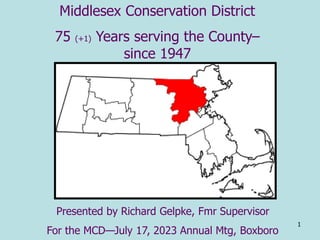
- 1. 1 Middlesex Conservation District 75 (+1) Years serving the County– since 1947 Presented by Richard Gelpke, Fmr Supervisor For the MCD—July 17, 2023 Annual Mtg, Boxboro
- 4. Outline --What are Conservation Districts? --The board --What we do--programs --Agriculture & land use in Massachusetts --Agriculture & land use in Middlesex County --Three Middlesex County Communities --Ashby --Concord --Framingham & Natick
- 5. 5 The mission of the Middlesex Conservation District--- Put conservation practices on the land using partners on voluntary basis
- 6. The MCD partners with the Natural Resources Conservation Service (NRCS--USDA) the ‘old’ Soil Conservation Service (to 1994) (space & office equip referral services & tech assist) Ma Exec Off Energy & Env Affairs support administ, education efforts pilot programs NRCS Dist Conservationist—Bob Purcell Land occupiers in county Elected to the Board
- 7. 7 5 2 2 4 1 1 3 4 3 4 1 3 2 4 5 3 1 1 1 3 1 1 Cambridge 1 3 Number of Supervisors by Towns (58 listed) County Office Locations
- 11. 11 Soil Survey for Middlesex County Completed in 1988On line Working with NRCS to Establish Conservation Practices on the Land thru Cooperative Agreements with Partners Public money on private land? Conservation Education: Seminars, Workshops, Newsletters and Presentations Sudbury-Assabet-Concord (SuAsCo) Watershed Project- Initiated in 1955 Baiting Brook Watershed Project Initiated 1956 Urban flooding Annual Plant and Tree Sales (First Plant Sale 1962) Camp Paul (A 12-acre tract of land in Chelmsford) Model Soil Erosion and Sediment Control Bylaw Envirothon (Created in 1979 by Pennsylvania Soil & Water Conservation Districts, the Envirothon was brought to Massachusetts in 1987 )
- 12. 12 Programs… Soils—workshops healthy Soils Initiative Work with Co farmers on cooperative programs with NRCS Tracks requests from ‘land occupiers’— farmers, municipalities and others Environmental Quality Incentives Program (NRCS)
- 14. NRCS & CD’s involved in wide range of issues beyond soils --open space & resource planning --subdivision review, erosion & sediment control --wildlife & fisheries habitat --urban forestry & farming --environmental education In the 1990s Farm Bills altered the CD-NRCS relationship --formerly land assist requests came thru the Districts --now applications directly to NRCS Formerly some budget support from the state --none for many years --2017 some funding from the state
- 16. The Plan as presented to the Board
- 17. The Plan as presented to the Board
- 21. 22 Mass Population 1900-2022 0 1000000 2000000 3000000 4000000 5000000 6000000 7000000 8000000 Year Population 1900 1950 2020
- 22. 23 Petersham decrease of ⅔ forested land 1831-1865 1870 farm census--thousands of small farms were out of production-- New England reported 400,000 acres of reduction in improved land. 1855 note to Middlesex Agricultural Society “hay fields were so depleted that they would scarcely support cattle” 1830-80% of Mass land cleared of trees for agriculture Timeline for Mass Agriculture
- 23. 24 Farm Census of 1900-1920 indicated New England lost 35,324 farms New England population increased 32% increasingly competitive products from the West poorly located and uneconomic New England farms to leave production Primarily due to the Dust Bowl-1935 the Soil Conservation Service, now the Natural Resources Conservation Service (NRCS) was created
- 24. 26 The Beginning of the Environmental Movement- the last 100 hundred years there has been a noted gradual increase in temperature. One direct result is the new hardiness zone map for the state The Pandemic, Supply Chains and Food Supply-
- 26. 28 Pre-settlement forest Early Settler Clears homestead 1740 Height of land clearing 1830
- 27. 29 Farm Abandonment 1850 Old Field White Pine 1910 White Pine to Hardwoods-- 1915
- 28. 30 Vigorously growing hardwoods 1930 The Modern Forest
- 29. 31 Middlesex County ranks 6th (of 14) in the state for the percent of Massachusetts farms… Only Worcester, Franklin, Hampshire, Plymouth & Bristol have more farms.
- 30. 32
- 31. $ value/acre % change 2020-2021
- 32. 34
- 33. 35 Massachusetts USDA Ag Census every 5 years
- 34. 36 1 2 3 3
- 35. 37
- 36. 38 Mass Agriculture Summary • mainly comprises of many small family farms • MA farmers face developmental pressure and rising costs • Direct sales to consumers account for a large proportion of overall sales • Succession planning is an important consideration for aging farmers • Off -farm income is important for farm financial stability
- 38. 40
- 39. 41
- 40. 42
- 41. 43 A look at three Middlesex County towns over time that the MCD has been serving the county… Ashby (center) Concord (Nine Acre Corner) Framingham-Natick (Shoppers World-Natick Mall)
- 42. 44 Town Populations 0 10000 20000 30000 40000 50000 60000 70000 80000 1950 1960 1970 1980 1990 2000 2010 2020 Population Ashby Concord Natick Framingham The 2020 populations: —Natick (~37K) & Framingham (72K) combine to ~100K Concord = 18K--Ashby ~ 3000 inhabitants
- 44. 46 Ashby Inc 1767 24 Sq M Pop 3200
- 45. 47 Ashby is located in far northwestern Middlesex County, on the New Hampshire state line—it is decidedly rural in nature.
- 46. 48 2017
- 47. 49 Ashby Town Center 1952 1992
- 49. 51 Concord 1635 26 Sq M Pop 18,500 Nine Acre Corner
- 50. 52 Concord is located in central part of the county. South of Concord center is the area known as ‘nine acre corner’ . It is at the junction of SR 117 & Sudbury Road—an important agricultural area still surrounded by large lot expensive homes..
- 52. 54 1950
- 53. 55 1952 1992
- 54. 56 Part of the Maynard soil Survey sheet (of the 1988 Survey) Showing the Nine Acre Corner area 223B—Scio very fine sandy loam, 3 to 8 percent slopes This very deep, gently sloping, moderately well drained soil is in shallow depressions on plains and on tops of stream terraces. Most areas …cropland or abandoned cropland… well suited to cultivated crops and …pasture. The seasonal high water table…management concern …may delay planting or harvesting. … suited for most forage grasses. Conservation tillage, contour farming, cover crops, and diversions help to control erosion
- 55. 57 Development pressures—Ag Pres Restrictions
- 59. Golden Triangle 2023 (MS Bing) C C
- 60. 62 Framingham & Natick Massachusetts Area known as the “Golden Triangle-- Shoppers World & adjacent Natick Mall Center of the MetroWest region of the state Framingham is a city --inc 1700 25 square miles population 72,362 Density 2,889.39/sq mi Natick is a town –inc 1781 16 Square miles population 37,006 Density 2,450.7/sq m
- 62. 64 1951-2 Rt 9
- 63. 66 2017 Framingham & Natick averaged 2017 definitions changed for ‘urban’
- 64. 67 Baiting Brook project Framingham Mass The Watershed Protection and Flood Prevention Act (PL- 566) authorizes NRCS to help local organizations and units of government plan and implement watershed projects. PL-566 watershed projects are locally led to solve natural and human resource problems in watersheds up to 250,000 acres (less than 400 square miles). Watershed Planning is done in cooperation with the USDA Natural Resources Conservation Service (NRCS). This is often part of Public Law 83-566 (as amended) - Watershed Protection and Flood Prevention Act (1954) projects. PL-566 projects are initiated by local communities through the districts
- 66. Upper Baiting Brook flows thru dense suburban, Framingham