


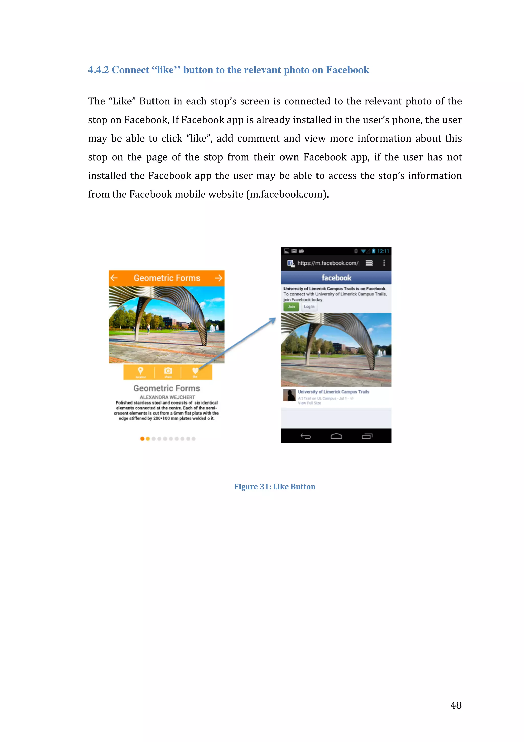
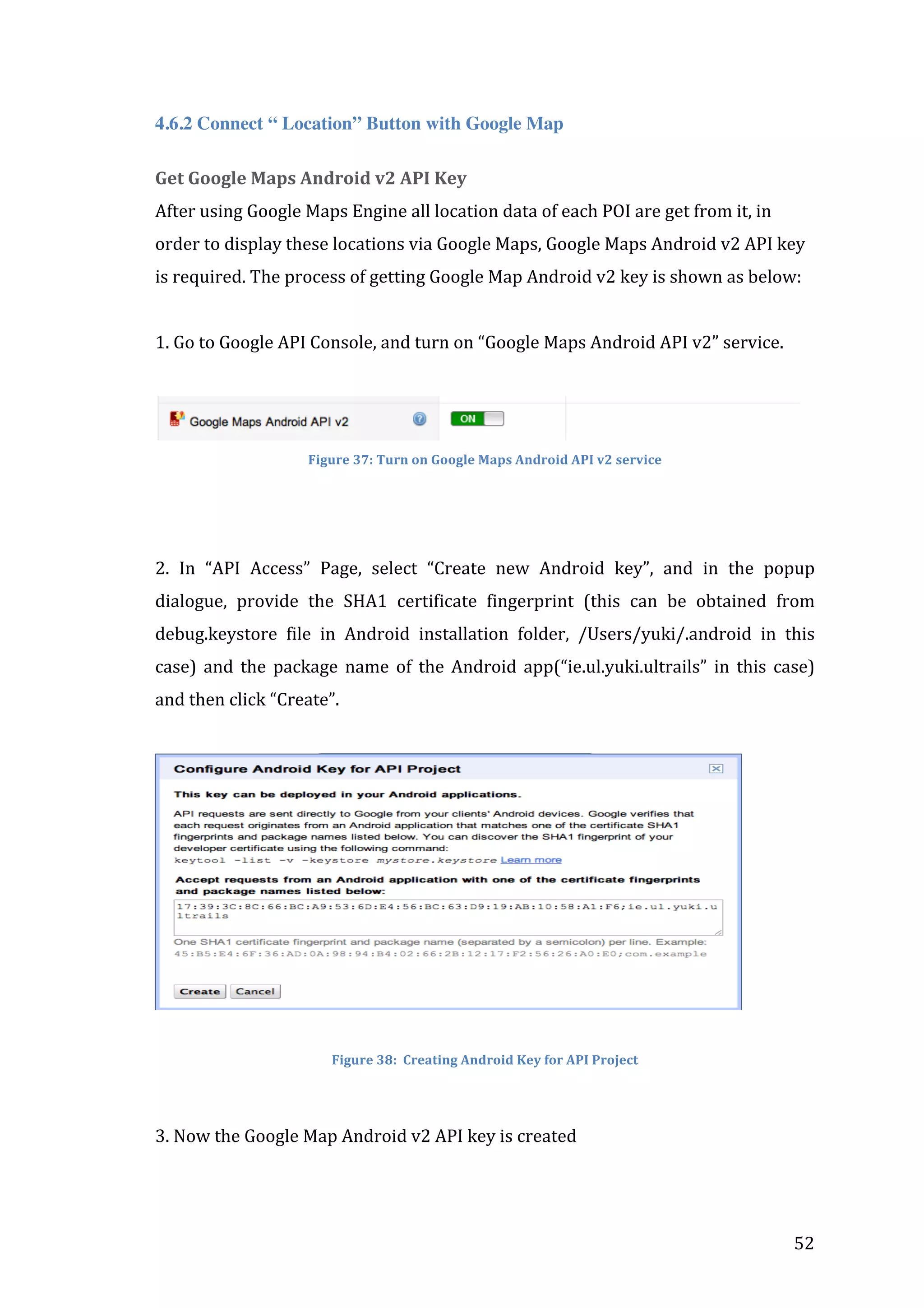


![mSettings.setScrollGesturesEnabled(true);
mSettings.setZoomGesturesEnabled(true);
mSettings.setTiltGesturesEnabled(true);
mSettings.setRotateGesturesEnabled(true);
mMap.setMyLocationEnabled(true);
}
}
Bundle
bundle
=
getIntent().getExtras();
int
loc_id
=
Integer.parseInt(bundle.getString("ID"));
mMap.addMarker(new
MarkerOptions()
.position(new
LatLng(mv.loc[loc_id][1],
mv.loc[loc_id][0]))
.title(mv.info[loc_id][0])
.snippet(mv.info[loc_id][1]));
}
}
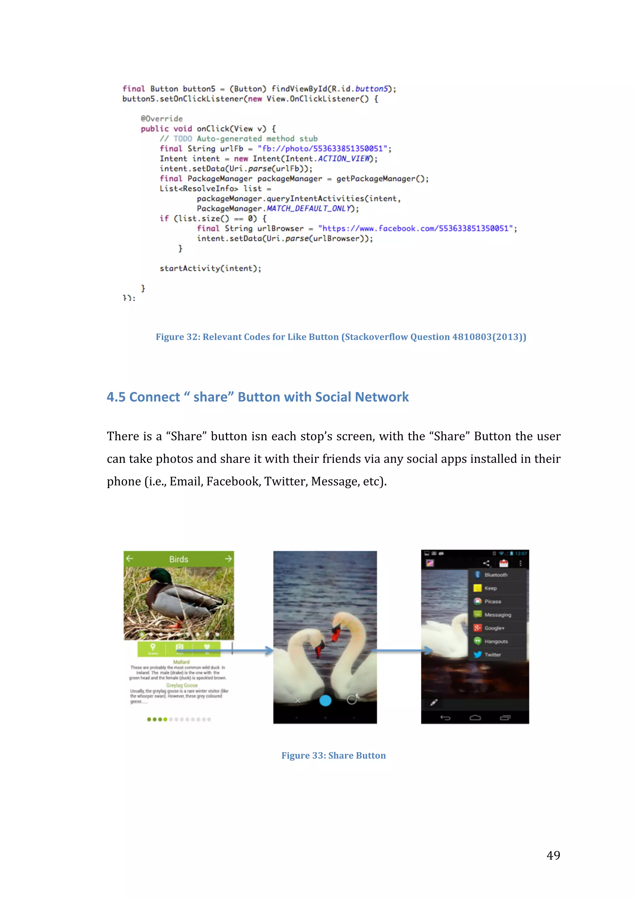
75](https://image.slidesharecdn.com/appdesignprocessyukijiang-131208130023-phpapp02/75/App-designprocess-yukijiang-75-2048.jpg)
![return
true;
}
}
Source
code
of
MapValues.java
package
ie.ul.yuki.ultrails;
public
class
MapValues
{
public
double
loc[][];
public
String
info[][];
public
MapValues()
{
loc
=
new
double[30][2];
info
=
new
String[30][2];
loc[0][0]
=
-‐8.5744509100914;
loc[0][1]
=
52.66871681247063;
info[0][0]
=
"Gate
Masts
and
Crann
Saoilse";
info[0][1]
=
"Located
at
the
Main
Entrance";
loc[1][0]
=
-‐8.577146530151367;
loc[1][1]
=
52.67318797585434;
info[1][0]
=
"Geometric
Forms";
info[1][1]
=
"Located
at
the
front
of
the
Robert
Schuman
Building";
loc[2][0]
=
-‐8.574389219284058;
loc[2][1]
=
52.67480782610112;
info[2][0]
=
"Silver
Pencils";
info[2][1]
=
"Located
at
the
Reflecting
Pool,
Foundation
Building";
loc[3][0]
=
-‐8.573933243751526;
loc[3][1]
=
52.67436871600413;
info[3][0]
=
"The
Water
Colour
Society
of
Ireland
National
Collection";
info[3][1]
=
"Located
in
the
Foundation
Building";
loc[4][0]
=
-‐8.573616743087769;
loc[4][1]
=
52.674219092296255;
77](https://image.slidesharecdn.com/appdesignprocessyukijiang-131208130023-phpapp02/75/App-designprocess-yukijiang-77-2048.jpg)
![info[4][0]
=
"Bourn
Vincent
Gallery";
info[4][1]
=
"Located
in
the
Foundation
Building";
loc[5][0]
=
-‐8.573884963989258;
loc[5][1]
=
52.674124764043256;
info[5][0]
=
"The
National
Self-‐Portrait
Collection
of
Ireland";
info[5][1]
=
"Located
in
the
Foundation
Building";
loc[6][0]
=
-‐8.572887182235718;
loc[6][1]
=
52.67497371098916;
info[6][0]
=
"Chancellor's
Walk";
info[6][1]
=
"Located
at
the
Millstream
Courtyard";
loc[7][0]
=
-‐8.571964502334595;
loc[7][1]
=
52.675477867076744;
info[7][0]
=
"Salmon
Fall";
info[7][1]
=
"Located
on
grounds
in
front
of
Plassey
House";
loc[8][0]
=
-‐8.570977449417114;
loc[8][1]
=
52.67436546332029;
info[8][0]
=
"The
Armitage
Collection";
info[8][1]
=
"Located
in
Plassey
House";
loc[9][0]
=
-‐8.571106195449829;
loc[9][1]
=
52.67439148478433;
info[9][0]
=
"The
Irish
American
Cultural
Institute's
O'
Malley";
info[9][1]
=
"Located
in
Plassey
House";
loc[10][0]
=
-‐8.570719957351685;
loc[10][1]
=
52.67447280175955;
info[10][0]
=
"The
University
of
Limerick
Mace";
info[10][1]
=
"Located
in
Plassey
House";
loc[11][0]
=
-‐8.570505380630493;
loc[11][1]
=
52.67437847405424;
78](https://image.slidesharecdn.com/appdesignprocessyukijiang-131208130023-phpapp02/75/App-designprocess-yukijiang-78-2048.jpg)
![info[11][0]
=
"Loans
and
Donations";
info[11][1]
=
"Located
in
Plassey
House";
loc[12][0]
=
-‐8.572468757629395;
loc[12][1]
=
52.67380925082015;
info[12][0]
=
"Together
and
Apart";
info[12][1]
=
"Located
at
the
Central
Plaza";
loc[13][0]
=
-‐8.571943044662476;
loc[13][1]
=
52.674137774848795;
info[13][0]
=
"The
University
of
Limerick
Art
Collection";
info[13][1]
=
"Located
in
the
Main
Building";
loc[14][0]
=
-‐8.57359528541565;
loc[14][1]
=
52.67309364537497;
info[14][0]
=
"Helen
Hooker
O'
Malley
Roelofs
Sculpture
Trust";
info[14][1]
=
"Located
in
the
Glucksman
Library";
loc[15][0]
=
-‐8.57334852218628;
loc[15][1]
=
52.673142437027636;
info[15][0]
=
"The
Conlan
Collection
of
Irish
Coins,
Tokens
and
Ring-‐Money";
info[15][1]
=
"Located
in
Special
Collections,
Glucksman
Library";
loc[16][0]
=
-‐8.572801351547241;
loc[16][1]
=
52.67342217478468;
info[16][0]
=
"Leaf
Litany";
info[16][1]
=
"Located
outside
the
Glucksman
Library";
loc[17][0]
=
-‐8.571288585662842;
loc[17][1]
=
52.673500240815805;
info[17][0]
=
"Sundial";
info[17][1]
=
"Located
between
the
Stables
Courtyard
and
the
main
building";
loc[18][0]
=
-‐8.567866086959839;
loc[18][1]
=
52.673815756270436;
info[18][0]
=
"Resurgence";
79](https://image.slidesharecdn.com/appdesignprocessyukijiang-131208130023-phpapp02/75/App-designprocess-yukijiang-79-2048.jpg)
![info[18][1]
=
"Located
to
the
left
of
the
Schrodinger
Building";
loc[19][0]
=
-‐8.56258749961853;
loc[19][1]
=
52.674908658166935;
info[19][0]
=
"Swimmers";
info[19][1]
=
"Located
in
Kilmurry
Village";
loc[20][0]
=
-‐8.57083261013031;
loc[20][1]
=
52.6739296014936;
info[20][0]
=
"Notable
Tress";
info[20][1]
=
"Located
in
the
close
behind
Plassey
House
and
to
the
east
of
the
Block
A";
loc[21][0]
=
-‐8.571133017539978;
loc[21][1]
=
52.674339441840736;
info[21][0]
=
"Lichen";
info[21][1]
=
"Located
round
Plassey
House
and
near
the
drop-‐down
point
to
the
Glucksman
Library";
loc[22][0]
=
-‐8.570285439491272;
loc[22][1]
=
52.676652040312995;
info[22][0]
=
"Birds";
info[22][1]
=
"Located
on
the
Shannon
River";
loc[23][0]
=
-‐8.570226430892944;
loc[23][1]
=
52.67724724627074;
info[23][0]
=
"Riparian
Woodland";
info[23][1]
=
"Located
along
the
Shannon
River";
loc[24][0]
=
-‐8.569518327713013;
loc[24][1]
=
52.67744889890901;
info[24][0]
=
"Animals
and
Insects";
info[24][1]
=
"Located
along
the
Shannon
River";
loc[25][0]
=
-‐8.579506874084473;
loc[25][1]
=
52.677419626809574;
80](https://image.slidesharecdn.com/appdesignprocessyukijiang-131208130023-phpapp02/75/App-designprocess-yukijiang-80-2048.jpg)
![info[25][0]
=
"Wild
Flowers
and
Fungi";
info[25][1]
=
"Wooded
areas
along
river
bank.Woodland
along
the
main
avenue
and
on
the
drier
ground
to
the
south
of
the
River
Shannon";
}}
Source
code
of
ArtStop1Activity.java
package
ie.ul.yuki.ultrails;
import
java.io.File;
import
java.util.List;
import
android.net.Uri;
import
android.os.Bundle;
import
android.os.Environment;
import
android.provider.MediaStore;
import
android.view.View;
import
android.widget.Button;
import
android.widget.Toast;
import
android.app.Activity;
import
android.content.Intent;
import
android.content.pm.PackageManager;
import
android.content.pm.ResolveInfo;
public
class
ArtStop1Activity
extends
Activity
{
Uri
tmp;
protected
void
onActivityResult(int
requestCode,
int
resultCode,
Intent
data)
{
super.onActivityResult(requestCode,
resultCode,
data);
if
(requestCode
==
1){
Intent
view
=
new
Intent(Intent.ACTION_VIEW);
view.setDataAndType(tmp,"image/*");
Toast.makeText(getBaseContext(),
"Click
the
Share
button
in
top
right
to
share",
Toast.LENGTH_LONG).show();
startActivity(view);
}
}
@Override
protected
void
onCreate(Bundle
savedInstanceState)
{
super.onCreate(savedInstanceState);
setContentView(R.layout.activity_art_stop1);
final
Button
button1
=
(Button)
findViewById(R.id.button1);
button1.setOnClickListener(new
View.OnClickListener()
{
@Override
81](https://image.slidesharecdn.com/appdesignprocessyukijiang-131208130023-phpapp02/75/App-designprocess-yukijiang-81-2048.jpg)


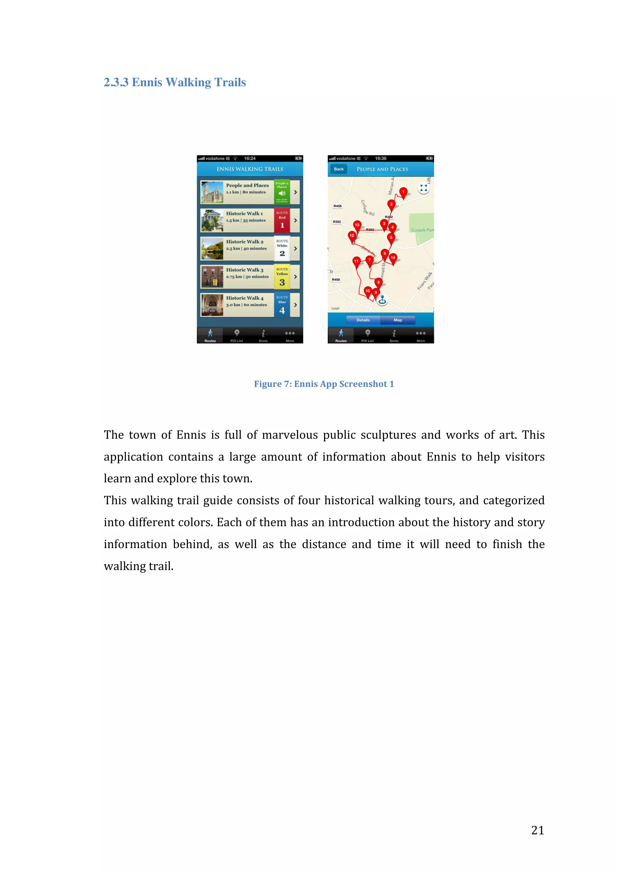
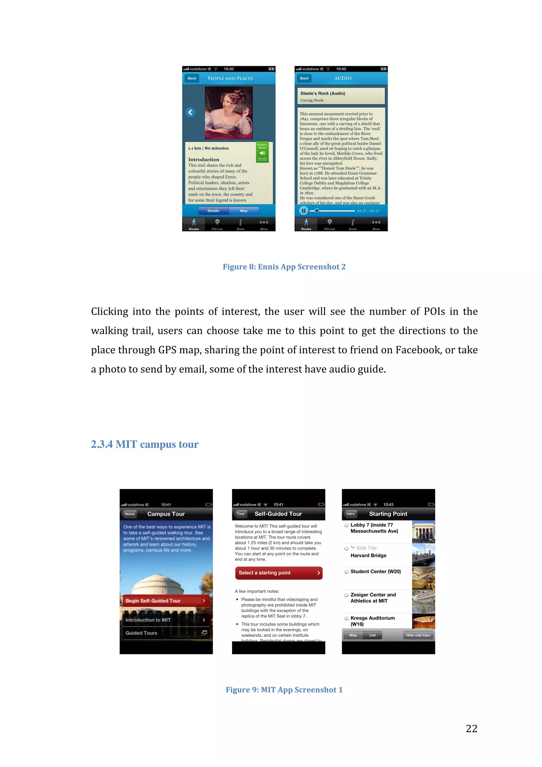
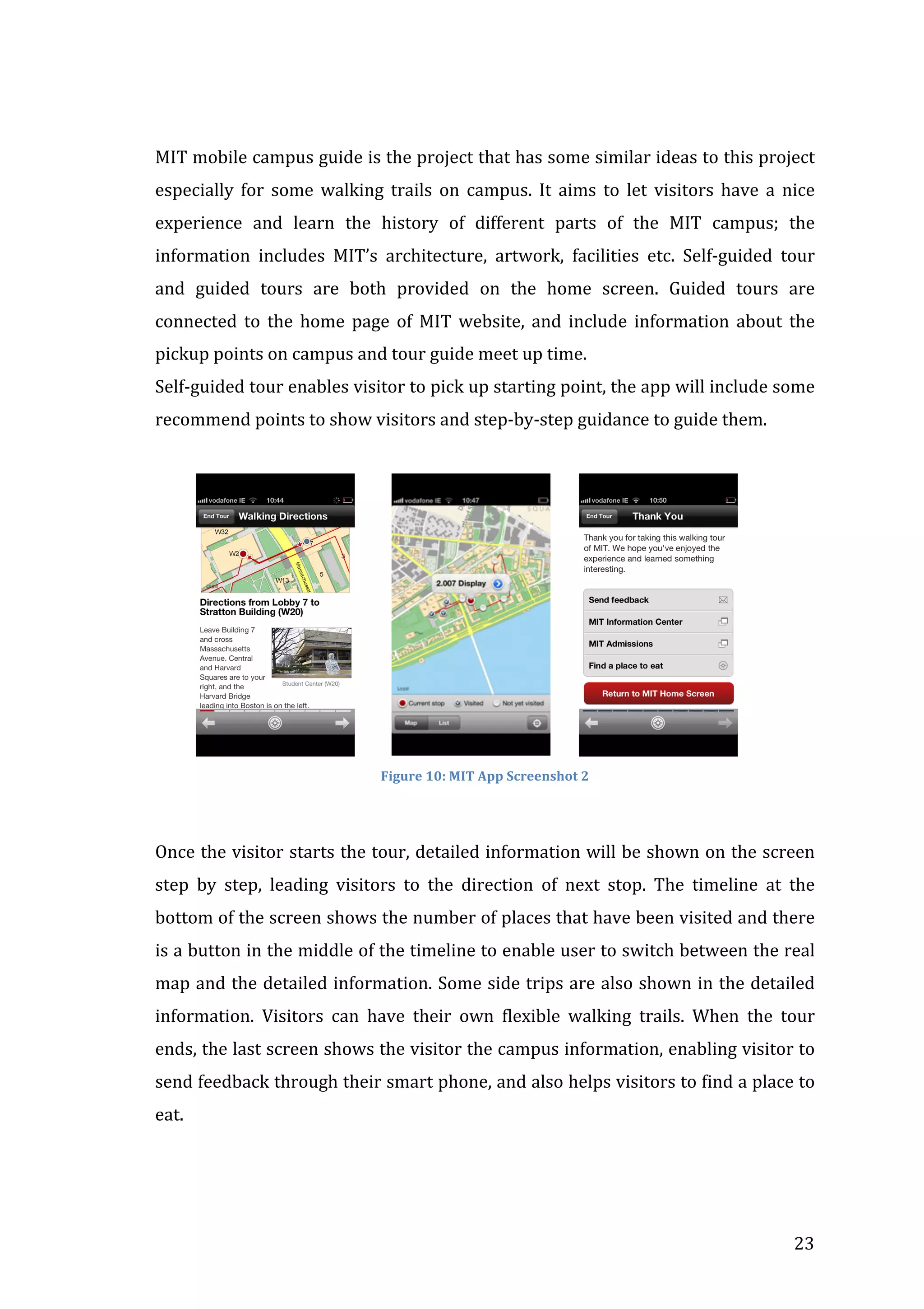
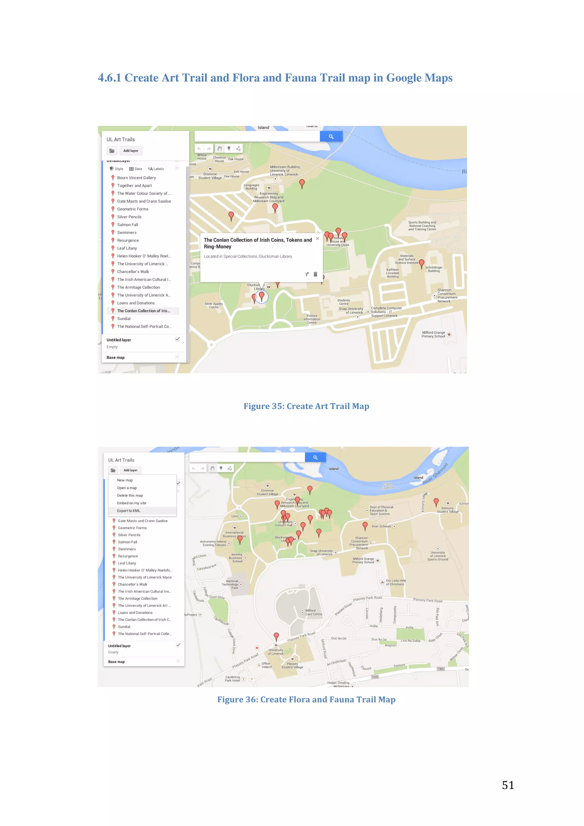
The document describes two trails at the University of Limerick campus: the Art Trail and the Flora and Fauna Trail. It provides an overview of the trails and notes that a mobile application will be developed to guide users along the trails, identifying points of interest and providing information. The application will allow users to view the trails on maps, like and share content, and access location services to find their position on the trails.