
Recommended
More Related Content
Similar to Disaster Management
Similar to Disaster Management (20)
Recently uploaded
Recently uploaded (20)
Disaster Management
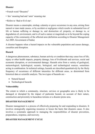
- 1. Disaster • French word “Desastre” • ‘des’ meaning bad and ‘aster’ meaning star • Refers to ‘Bad or Evil star’. Disaster means a catastrophe, mishap, calamity or grave occurrence in any area, arising from natural or man made causes, or by accident or negligence which results in substantial loss of life or human suffering or damage to, and destruction of, property, or damage to, or degradation of, environment, and is of such a nature or magnitude as to be beyond the coping capacity of the community of the affected area (definition according to Disaster Management Act 2005, Government of India) A disaster happens when a hazard impacts on the vulnerable population and causes damage, casualties and disruption. Hazard A dangerous phenomenon, substance, human activity or condition that may cause loss of life, injury or other health impacts, property damage, loss of livelihoods and services, social and economic disruption, or environmental damage. Hazards arise from a variety of geological, meteorological, hydrological, oceanic, biological, and technological sources, sometimes acting in combination. In technical settings, hazards are described quantitatively by the likely frequency of occurrence of different intensities for different areas, as determined from historical data or scientific analysis. The two types of hazards are - Natural hazard Technological hazards Vulnerability The extent to which a community, structure, services or geographic area is likely to be damaged or disrupted by the impact of particular hazard, on account of their nature, construction and proximity to hazardous terrains or a disaster prone area. DISASTER MANAGEMENT Disaster management is a process of effectively preparing for and responding to disasters. It involves strategically organizing resources to lessen the harm that disasters cause. It also involves a systematic approach to managing the responsibilities of disaster prevention, preparedness, response, and recovery. DISASTER MANAGEMENT CYCLE
- 2. Includes sum total of all activities, programmes and measures taken up before, during, and after a disaster with the purpose to avoid a disaster, reduce its impact or recover from its losses. The three key stages of activities within disaster risk management are: 1. Before a disaster (pre-disaster). Activities to reduce human and property losses caused by a potential hazard. Example, by carrying out awareness campaigns, strengthening the existing weak structures, preparation of the disaster management plans at household and community level etc. Such risk reduction measures taken under this stage are termed as mitigation and preparedness activities. 2. During a disaster (disaster occurrence). Initiatives taken to ensure the needs and provisions of victims are met and suffering is minimized. Activities taken under this stage are called emergency response activities. 3. After a disaster (post-disaster) Initiatives taken in response to a disaster with a purpose to achieve early recovery and rehabilitation of affected communities, immediately after a disaster strikes. These are called as response and recovery activities. DISASTER EMERGENCY KIT When a natural disaster occurs, we can't always rely on police or governments to provide help. The grocery store might be so badly damaged that you can't go into it. The supplies in the store might be quickly depleted or you may not be able to get to the store. the six basic supplies you need in a disaster kit are: Water Food First aid supplies Clothing, bedding and sanitation supplies Tools Special items FLOOD A flood is an overflow of an expanse of water that submerges land. Flood is defined as a covering by water of land which is not normally covered by water. In the sense of "flowing water", the word may also be applied to the inflow of the tide. Flooding may result from the
- 3. volume of water within a body of water, such as a river or lake, which overflows or breaks levees, with the result that some of the water escapes its usual boundaries. Floods often cause damage to homes and businesses if they are placed in natural flood plains of rivers. While flood damage can be virtually eliminated by moving away from rivers and other bodies of water, since time out of mind, people have lived and worked by the water to seek sustenance and capitalize on the gains of cheap and easy travel and commerce by being near water. That humans continue to inhabit areas threatened by flood damage is evidence that the perceived value of living near the water exceeds the cost of repeated periodic flooding. Causes of Floods Flood is usually a result of natural causes. It may also be caused by man-made factors. There are many different causes leading to flooding. Some prominent among them include: Massive Rainfall Overflowing of the Rivers Collapsed Dams Snowmelt Deforestation Climate change Emission of Greenhouse Gases Other Factors
- 4. Effects of flooding Effects of flooding can be both positive and negative. For millennia, people have settled near rivers and lakes because water is easily accessible and the soil is fertile. Back in the days though, people constructed on higher grounds allowing riverine floods to enrich the land with nutrients. Floods are in reality very important processes for the natural environment. And humans also benefit from them. However, they also have a number of negative effects. Positive effects of flooding In many rural regions around the world, the livelihoods of many communities depend on annual flood cycles. Examples include riverine settlements along the Amazon forest like Peruvian and Columbian communities. This is because floods facilitate transportation, fish migrations and make the soil fertile. Thus, seasonal flooding has many positive effects such as 1. Flooding makes the land fertile
- 5. 2. Flooding adds nutrients to the sea 3. Dislodges accumulated debris 4. Supplies sediment to deltas 5. Floods recharge groundwater 6. Flooding balances the health of wetlands a. Helps to maintain chemical balance b. Restore breeding grounds c. Increase biodiversity stock Negative effects of flooding We have to keep in mind that flooding is a natural process in the environment. It becomes a problem when people live/build too close to floodplains. Or when they modify the land so much that it can no longer absorb water. So, the negative effects of flooding are - 1. Floods damage built infrastructure 2. Flooding leads to economic losses 3. Loss of lives and social disruption 4. Extreme floods cause erosion 5. Flooding causes algal blooms
- 6. TYPES OF FLOODS Over recent years, floods have hit the headlines on several occasions. But not all floods are equal and there are in fact many different types. 1. Coastal Flooding
- 7. 2. River Flooding 3. Flash Flooding 4. Groundwater Flood 5. Drain and Sewer Flooding FLASH FLOOD Vs RIVER FLOOD Flash floods are distinguished from a regular flood by a timescale of less than six hours Flood prone area in India The states falling within the periphery of "India Flood Prone Areas" are West Bengal, Orissa, Andhra Pradesh, Kerala, Assam, Bihar, Gujrat, Uttar Pradesh, Haryana and Punjab. The intense monsoon rains from southwest causes rivers like Brahmaputra, Ganga, Yamuna etc. to swell their banks, which in turn floods the adjacent areas. Over the past few decades, central India has become familiar with precipitation events like torrential rains and flash floods. The major flood prone areas in India are the river banks and deltas of Ravi, Yamuna-Sahibi, Gandak, Sutlej, Ganga, Ghaggar, Kosi, Teesta, Brahmaputra, Mahanadi, Mahananda, Damodar, Godavari, Mayurakshi, Sabarmati and their tributaries.
- 9. An over-view about state-wise flood prone areas can be gained by checking the following table: Highest flood prone areas in India Though the north-Indian plains prone to flood more, the "India flood prone areas" can be broadly categorized in three divisions: 1. Ganga Basin 2. Brahmaputra and Barak Basins 3. Central India and Deccan Rivers Basin Average Annual Flood Damage (1953 - 1999) Total Damage Rs.13,400 million Area Affected 8.11 million hectare Crop Area Affected 3.57 million hectare Human Lives Lost 1579 Nos. Cattle Lost 95,000 Nos. State Area liable to Floods (million Ha.) Uttar Pradesh 7.336 Bihar 4.26 Punjab 3.7 Rajasthan 3.26 Assam 3.15 West Bengal 2.65 Haryana 2.35 Orissa 1.4 Andhra Pradesh 1.39 Gujarat 1.39 Kerala 0.87 Tamil Nadu 0.45 Tripura 0.33 Madhya Pradesh 0.26 Himachal Pradesh 0.23 Maharashtra 0.23 Jammu & Kashmir 0.08 Manipur 0.08 Delhi 0.05 Karnataka 0.02 Meghalaya 0.02 Pondichery 0.01 Total 33.516
- 10. Preparing for floods (Do’s and don’ts) To prepare for a flood, one should: Avoid building in flood prone areas unless you elevate and reinforce your home. Elevate the furnace, water heater, and electric panel if susceptible to flooding. Install "Check Valves" in sewer traps to prevent floodwater from backing up into the drains of your home. Contact community officials to find out if they are planning to construct barriers (levees, beams and floodwalls) to stop floodwater from entering the homes in your area. Seal the walls in your basement with waterproofing compounds to avoid seepage. If a flood is likely to hit one’s area, one should: Listen to the radio or television for information. Be aware that flash flooding can occur. If there is any possibility of a flash flood, move immediately to higher ground. Do not wait for instructions to move. Be aware of streams, drainage channels, canyons, and other areas known to flood suddenly. Flash floods can occur in these areas with or without such typical warnings as rain clouds or heavy rain. If one must prepare to evacuate, one should: Secure your home. If you have time, bring in outdoor furniture. Move essential items to an upper floor. Turn off utilities at the main switches or valves if instructed to do so. Disconnect electrical appliances. Do not touch electrical equipment if you are wet or standing in water. If you have to leave your home, remember these evacuation tips: Do not walk through moving water. Six inches of moving water can make you fall. If you have to walk in water, walk where the water is not moving. Use a stick to check the firmness of the ground in front of you. Do not drive into flooded areas. If floodwaters rise around your car, abandon the car and move to higher ground if you can do so safely. You and the vehicle can be quickly swept away.
- 13. Recent floods in India (2019-2021) August 2019 Indian floods including 2019 Kerala floods: Following high rain in late July and early August 2019, series of floods that affected over nine states in India. The states of Kerala, Madhya Pradesh, Karnataka, Maharashtra and Gujarat were the most severely affected. Brahmaputra floods: The 2019 Brahmaputra Floods, till 16 July, affected a total of 52,59,142 people, 1,63,962.02 hectares of crop area, in 30 districts in the state of Assam. At least 3,024 villages in the affected districts continued to be underwater and 44,08,142 people are hit in several districts. Notably, in this wave of floods, 2400 endangered species of Indian rhinoceros in Kaziranga National Park were badly affected. 2020 Assam floods: Initial flooding started in May 2020 due to heavy rainfall affecting 30,000 and destroying crops across 5 districts. As of October 2020 the floods affected over five million people, claiming the lives of 123 people, with an additional 26 deaths due to landslides, 5474 villages were affected and over one hundred and fifty thousand people found refuge in relief camps. 2020 Hyderabad floods: The 2020 Hyderabad floods were a series of floods associated with Deep Depression BOB 02 that caused extensive damage and loss of life as a result of flash flooding in Hyderabad, India in October 2020. The fourth tropical cyclone and third deep depression of the 2020 North Indian Ocean cyclone season, BOB 02 formed on 11 October over the west-central Bay of Bengal and slowly drifted towards the east coast of India over the following three days. 2021 Uttarakhand flood: The 2021 Uttarakhand flood, also known as the Chamoli disaster, began on 7 February 2021 in the environs of the Nanda Devi National Park, a UNESCO World Heritage Site in the outer Garhwal Himalayas in Uttarakhand state. It was caused by a large rock and ice avalanche consisting of material dislodged from Ronti peak. It caused flooding in the Chamoli district, most notably in the Rishiganga river, the Dhauliganga river, and in turn the Alaknanda—the major headstream of the Ganges. The disaster left over 200 killed or missing. Most were workers at the Tapovan dam site.
- 14. 2021 Maharashtra floods: A series of floods took place across the Indian state of Maharashtra in 2021. As of 28 July 2021, around 251 people had died and over 100 were still missing due to floods and landslides. Thirteen districts have been affected in western Maharashtra. The flood was part of a series of tightly clustered extreme weather events in July 2021, including extreme rain events in Henan, China and Europe and is part of an increase in rain events during the Indian monsoon season caused by climate change. Prevention and Mitigation measures of floods in India. Prevention – encompasses activities designed to provide permanent protection from disasters. It includes engineering and other physical protective measures, and also legislative measures controlling land use and urban planning. Humans cannot stop the rains from falling or stop flowing surface water from bursting its banks. These are natural events, but we can do something to prevent them from having a great impact. Here are a few –
- 15. Sea / Coastal Defence Walls Sea walls and tide gates have been built in some places to prevent tidal waves from pushing the waters up ashore. In some areas too, sandbags are made and placed in strategic areas to retain floodwaters. Retaining walls In some places, retaining walls levees, lakes, dams, reservoirs, or retention ponds have been constructed to hold extra water during times of flooding. Town planning Builders must acquire permission before buildings are erected. That will ensure that waterways are not blocked. Also, drainage systems must be covered and kept free from objects that chock them. This way, water can quickly run through if it rains and minimizes any chance of town flooding. Drainage systems should also be covered to prevent litter from getting into them. Vegetation Trees, shrubs, and grass help protect the land from erosion by moving water. People in low- lying areas must be encouraged to use a lot of vegetation to help break the power of moving flood water and also help reduce erosion. Education In many developing countries, drainage systems are chocked with litter and people have little knowledge of the effects that can have during rain. When it rains, waterways and culverts are blocked by massive chunks of litter and debris, and water finds its way into the streets and people’s homes. Education is therefore very important, to inform and caution people about the dangers of floods, what causes floods, and what can be done to minimize its impact. Detention basin These are small reservoirs built and connected to waterways. They provide temporary storage for floodwaters. This means in an event of flooding, water is drained into the basin first, giving people more time to evacuate. It can also reduce the magnitude of downstream flooding.
- 16. The flood mitigation measures may be classified into structural and non-structural measures. The structural measures are physical in nature and aim to prevent flood waters from reaching potential damage areas, whereas non-structural measures strive to keep the people away from flood waters. Non-structural measures for flood mitigation Non-structural measures strive to keep people away from flood waters. These measures allow the use of flood plains judiciously by reducing the disaster dimension, while retaining its beneficial effects Rain Water Harvesting for flood mitigation Rainwater Harvesting is employed in flood mitigation in rain-drenched countries, and in solving infiltration problems of sealed surfaces in urban areas and industrial complexes, or in avoiding polluted water and toxic ground water. Mostly, RWH is environmentally sound as it assists in recharging ground water, enhances wetlands, forest conservation, encourages ecological farming, and slows down construction of new dams for water supply thus helping the ecological flow.
- 17. River basin management for flood mitigation River Basin Management includes all aspects of Hydrology, Ecology, Environmental Management, Wetlands and Flood Plains. River Basin Management deals with technical, as well as socio-economic and ecological aspects and calls for an integrated approach. This approach consists of a comprehensive set of analysis steps, supported by mathematical tools for the analysis of natural resource systems in a socio-economic context. Resilient structures for flood mitigation Flood resilient structures are such structures that can recover from a flood in less time with reduced damage to the property. This does not prevent the flood from entering a building but controls the possible damage that can result from flooding. As part of this approach, the form of buildings, their occupation and use of materials will need to consider the range of flood conditions to which they may be exposed.
- 18. Bibliography https://en.wikipedia.org/wiki/Floods_in_India https://ndma.gov.in/Natural-Hazards/Floods/Do-Donts https://www.mapsofindia.com/top-ten/geography/india- flood.html#:~:text=The%20major%20flood%20prone%20areas%20in%20India%20are%20t he%20river,Mayurakshi%2C%20Sabarmati%20and%20their%20tributaries. https://publichealth.tulane.edu/blog/what-is-disaster-management/ http://www.jnkvv.org https://www.toppr.com/guides/chemistry/environmental-chemistry/floods/ https://www.fluvial-innovations.co.uk/ https://www.yonature.com/ Langill, J.C. and Abizaid, C., 2019. What is a bad flood? Local perspectives of extreme floods in the Peruvian Amazon. Ambio, pp.1-14. Keller, E. and DeVecchio, D., 2015. Natural hazards: earth’s processes as hazards, disasters, and catastrophes. Pearson Higher Education AU. https://www.envirotech-online.com/news/water-wastewater/9/breaking-news/what-are-the- different-types-of-floods/31906 https://www.dreamstime.com/main-types-floods-flooding-infographic-flood-natural-disaster- rainstorm-weather-hazard-houses-cars-trees-covered-water-image213986727 https://www.alamy.com/flood-safety-tips-and-preparation-before-during-and-after-the- emergency-vector-infographic-image216574218.html https://eschooltoday.com/learn/flood-prevention-methods/