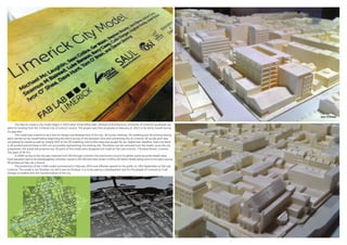
SlideShare a Scribd company logo
1 of 1
Download to read offline
The idea to create a city model began in 2013 when three fellow SAUL (School of Architecture, University of Limerick) graduates ap-
plied for funding from the ‘Limerick City of Culture’ council. The project was then proposed in February of 2014 to be led by myself during
my gap year.
	 The model was created to be a tool for design and development of the city. All survey methods, 3d modeling and 3d printing testing
were carried out by myself before beginning the entire survey of the Georgian Core and connecting City of Limerick. All survey work was
completed by myself as well as roughly 50% of the 3D modeling until further help was sought for our September deadline. Each city block
is 3D printed and the base is CNC cut, accurately representing the existing city. The blocks can be removed from the model, so as the city
progresses, the model will progress too. All parts of the model were designed and made at Fab Lab Limerick, 7 Rutland Street, Limerick
City (part of SA UL).
	 A LIDAR survey of the city was received from OSI through Limerick City and County Council to gather some accurate height data.
Each elevation had to be photographed, stitched, traced in 2D CAD and then drawn in Rhino 3D before finally being sent to the open source
3D printers at Fab Lab Limerick.
	 The production of the 1:500 model commenced in February 2014 and officially opened to the public on 19th September at Fab Lab
Limerick. The model is not finished, nor will it ever be finished. It is to be used as a development tool for the people of Limerick so it will
change in tandem with the transformation of the city.

More Related Content

Similar to StephenBourke_ArchPortfolio-min.2

From Smart Cities to Responsive Cities: how to bring citizens back to the cen...
From Smart Cities to Responsive Cities: how to bring citizens back to the cen...From Smart Cities to Responsive Cities: how to bring citizens back to the cen...
From Smart Cities to Responsive Cities: how to bring citizens back to the cen...
Speck&Tech
 
Urban Stories: complete documentation
Urban Stories: complete documentationUrban Stories: complete documentation
Urban Stories: complete documentation
Céline Kniebihler
 
Smart CitySDK at Apps for Smart Cities
Smart CitySDK at Apps for Smart CitiesSmart CitySDK at Apps for Smart Cities
Smart CitySDK at Apps for Smart Cities
Gregor Abbas
 
BoDW '11 - Mobile Detour
BoDW '11 - Mobile DetourBoDW '11 - Mobile Detour
BoDW '11 - Mobile Detour
Ronald Lenz
 

Similar to StephenBourke_ArchPortfolio-min.2 (15)

From Smart Cities to Responsive Cities: how to bring citizens back to the cen...
From Smart Cities to Responsive Cities: how to bring citizens back to the cen...From Smart Cities to Responsive Cities: how to bring citizens back to the cen...
From Smart Cities to Responsive Cities: how to bring citizens back to the cen...
 
Muenster_Portfolio_2016
Muenster_Portfolio_2016Muenster_Portfolio_2016
Muenster_Portfolio_2016
 
Towards A 4D Digital Smart City
Towards A 4D Digital Smart CityTowards A 4D Digital Smart City
Towards A 4D Digital Smart City
 
The 4D Digital Smart City Presentation
The 4D Digital Smart City PresentationThe 4D Digital Smart City Presentation
The 4D Digital Smart City Presentation
 
IxD Information Session
IxD Information SessionIxD Information Session
IxD Information Session
 
Urban Stories: complete documentation
Urban Stories: complete documentationUrban Stories: complete documentation
Urban Stories: complete documentation
 
Smart CitySDK at Apps for Smart Cities
Smart CitySDK at Apps for Smart CitiesSmart CitySDK at Apps for Smart Cities
Smart CitySDK at Apps for Smart Cities
 
EDF2014: Talk of Frank Kresin, Research Director, Waag Society, Netherlands: ...
EDF2014: Talk of Frank Kresin, Research Director, Waag Society, Netherlands: ...EDF2014: Talk of Frank Kresin, Research Director, Waag Society, Netherlands: ...
EDF2014: Talk of Frank Kresin, Research Director, Waag Society, Netherlands: ...
 
Portfolio 9.8
Portfolio 9.8Portfolio 9.8
Portfolio 9.8
 
Snap4City November 2019 Course: Smart City API, federation, Web and Mobile Ap...
Snap4City November 2019 Course: Smart City API, federation, Web and Mobile Ap...Snap4City November 2019 Course: Smart City API, federation, Web and Mobile Ap...
Snap4City November 2019 Course: Smart City API, federation, Web and Mobile Ap...
 
UP San Francisco 2012 Recap
UP San Francisco 2012 RecapUP San Francisco 2012 Recap
UP San Francisco 2012 Recap
 
Andrea Maruri CV
Andrea Maruri CVAndrea Maruri CV
Andrea Maruri CV
 
Vizerra - innovations in visual communications using games and VR&AR
Vizerra - innovations in visual communications using games and VR&ARVizerra - innovations in visual communications using games and VR&AR
Vizerra - innovations in visual communications using games and VR&AR
 
RV 2014: Online Tools + Transit Apps = 1 Unique Experience
RV 2014: Online Tools + Transit Apps = 1 Unique ExperienceRV 2014: Online Tools + Transit Apps = 1 Unique Experience
RV 2014: Online Tools + Transit Apps = 1 Unique Experience
 
BoDW '11 - Mobile Detour
BoDW '11 - Mobile DetourBoDW '11 - Mobile Detour
BoDW '11 - Mobile Detour
 

StephenBourke_ArchPortfolio-min.2

  • 1. The idea to create a city model began in 2013 when three fellow SAUL (School of Architecture, University of Limerick) graduates ap- plied for funding from the ‘Limerick City of Culture’ council. The project was then proposed in February of 2014 to be led by myself during my gap year. The model was created to be a tool for design and development of the city. All survey methods, 3d modeling and 3d printing testing were carried out by myself before beginning the entire survey of the Georgian Core and connecting City of Limerick. All survey work was completed by myself as well as roughly 50% of the 3D modeling until further help was sought for our September deadline. Each city block is 3D printed and the base is CNC cut, accurately representing the existing city. The blocks can be removed from the model, so as the city progresses, the model will progress too. All parts of the model were designed and made at Fab Lab Limerick, 7 Rutland Street, Limerick City (part of SA UL). A LIDAR survey of the city was received from OSI through Limerick City and County Council to gather some accurate height data. Each elevation had to be photographed, stitched, traced in 2D CAD and then drawn in Rhino 3D before finally being sent to the open source 3D printers at Fab Lab Limerick. The production of the 1:500 model commenced in February 2014 and officially opened to the public on 19th September at Fab Lab Limerick. The model is not finished, nor will it ever be finished. It is to be used as a development tool for the people of Limerick so it will change in tandem with the transformation of the city.