2010 10 Archaeology around the Severn Estuary – Andy Marvell
•Download as PPS, PDF•
1 like•320 views

Archaeology around the Severn Estuary – Andy Marvell

Recommended
More Related Content
What's hot
What's hot (19)
Viewers also liked
Similar to 2010 10 Archaeology around the Severn Estuary – Andy Marvell
Similar to 2010 10 Archaeology around the Severn Estuary – Andy Marvell (20)
More from SevernEstuary
More from SevernEstuary (20)
Recently uploaded
Recently uploaded (20)
2010 10 Archaeology around the Severn Estuary – Andy Marvell
- 1. Archaeology around the Severn Estuary
- 2. Archaeology around the Severn Estuary
- 3. Archaeology around the Severn Estuary
- 4. Archaeology around the Severn Estuary
- 5. Archaeology around the Severn Estuary
- 6. Archaeology around the Severn Estuary
- 7. Archaeology around the Severn Estuary
- 8. Archaeology around the Severn Estuary
- 9. Archaeology around the Severn Estuary
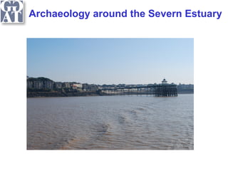
- 10. Archaeology around the Severn Estuary Birnbeck Pier (LB II*) in the foreground: Worlebury hill fort lies in the woods centre left: Knightstone Island with its Listed Theatre and Regency Baths in the mid-ground, and all the Victorian sea front features.
- 11. Archaeology around the Severn Estuary
- 12. Archaeology around the Severn Estuary National Bodies: English Heritage; Cadw; RCAHMW. Local Archaeological Curators: Bristol City Council: RH Jones, City Archaeologist. Tel: 0117 9223044e-mail: bob.jones@bristol.gov.uk Gloucestershire County Council: Jan Wills, County Archaeologist. Tel: 01452 425683 e-mail: jan.wills@gloucestershire.gov.uk North Somerset Council: Vince Russett, Archaeological Officer. Tel: 01934 426456. e-mail: vince-russett@n-somerset.gov.uk South Gloucestershire Council: David Haigh, Tel: 01454 863464 e- mail:David.Haigh@southglos.gov.uk South Wales: Neil Maylan, Archaeological Planning Manager, GGAT. Tel: 01792 655208 e-mail:neil@ggat.org.uk
Editor's Notes
- Humans have been exploiting the land around the Severn Estuary since before it began to form at the end of the last Ice Age, and to do justice in describing any aspect of the substantial evidence-base for human existence and endeavour over time in and around the Severn Estuary would take far longer than the short period of time that is available today. Coastal erosion in the Severn Estuary exposes a complete sedimentary sequence of the last 10,000 years including former dry land, saltmarsh and peat bog environments. Within these sediment sequences is the richest coastal archaeological evidence yet located in Britain. The area provides exceptional preservation for waterlogged wood structures and a wide range of environmental evidence. This will be but a brief snapshot, but should leave you with an understanding of the richness of the Severn Estuary’s Historic Environment and archaeological remains and how there protection, conservation and, where appropriate controlled investigation, are managed.
- It should come as no surprise that the estuary contains many wreck remains, although few (just four on the Welsh side) are protected. This slide kindly provided by Wessex Archaeology from data prepared as part of the Strategic Environmental Assessment for alternative Severn Tidal Power options shows the distribution of known wreck sites as recorded by English Heritage and the Royal Commission on Ancient and Historical Monuments in Wales, and as with other Historic Environmental data sets will be but a small fraction of total; almost all of these will be wrecks that occurred in the last four hundred years. Management of the marine environment is complex but it is this access that has shaped the use of the estuary.
- It may seem obvious to point out that there are three major ports, Bristol, Cardiff, Newport which are also cities, and indeed at the upstream end Gloucester, would also have these attributions, and should probably be included. What is important to remember is that these major conurbations all have medieval foundations, and in some cases earlier Roman settlement contain thousands of Historic Assets, whether protected as Scheduled Ancient Monuments or Listed Buildings or as sites registered on the Historic Environment Records held or adopted by local authorities. However, alongside these are numerous smaller towns, some such as Chepstow, themselves historic ports, and other smaller settlements many with landing/departure points. There are as many Historic Assets outside the urban centres as within them, as the next slides will perhaps illustrate.
- The first (again from the data compiled by Wessex Archaeology as part of the recent Severn Tidal Power assessment work) shows the Ancient Monuments protected through Scheduling under the provisions of the 1979 Ancient Monuments and Archaeological Areas Act.
- The second, also from the Wessex Archaeology STP Assessment data collection, the listed buildings. If the scatter diagram of the sites that are recorded on the HERs but are not listed or scheduled was to be presented at this scale there would be too many - it would be a solid, thick and deep black line. Yet whilst all this data has been captured we know that there is considerably more that remains to be discovered.
- Over the last 25 years two strands of archaeological activity have resulted not only in spectacular discoveries but also revealed much about the palaeotopography and palaeoenvironment of the estuary. The first strand has been focused research undertaken primarily by academic bodies but also by archaeological trusts with funding from Cadw or English Heritage. The work of archaeologists at University of Reading, notably Professors John Allen and Martin Bell,which has been focused in inter-tidal areas has done much to develop our understanding of the sedimentary sequences in the estuary and how the coastal areas were exploited in the past. When coastal erosion in the Severn Estuary occurs it is possible to expose a complete sedimentary sequence of the last 10,000 years including former dry land saltmarsh and peat environments within these sediment sequences is some of the richest coastal archaeological evidence yet located in Britain and the area provides exceptional preservation for waterlogged wood structures and a wide range of palaeoenviromental evidence that not only informs us about past environments but is an important dataset for understanding past climate change impacts. Sites investigated include mesolithic forests, Iron Age and Bronze Age rectangular structures and roundhouses, trackways and fish traps of many periods. Others such has Dr Stephen Rippon at the University of Exeter have worked on landscape development, and particularly ancient and historic reclamation.
- The second strand has occurred as a result of undertaking archaeological investigation and mitigation works ahead of or during development, with the works undertaken by archaeological contractors whether Trusts or private companies. The most notable practitioners in the area being the Glamorgan-Gwent Archaeological Trust, Wessex Archaeology and Bristol and Regional Archaeological Services. This work has resulted in some spectacular discoveries such as the 15th century Newport Ship and 3rd century Barland’s Farm boat. Increasing awareness of the archaeological potential of the area led to the formation of the The Severn Estuary Levels Research Committee 20 years ago and it has served as a forum to allow interchange of ideas and discoveries. Both strands of work have resulted in a large number of academic publications in journals including the area specific Archaeology in the Severn Estuary (up to vol 20) and several monographs.
- Much of the archaeology surviving in the levels can be ephemeral and can be easily missed. There is no consistent pattern across the estuary to periods of marine transgression and regression but markers for dryer interludes can be seen on both sides of the Estuary. These slides from Cabot Park, Avonmouth illustrate the point the two gleyed layers at the bottom of the first slide (top right) are makers of a previous stable ground surface that has subsequently become waterlogged, the episodes occurring 3-3,500 years ago, the largest slide shows the vestigial bronze age site occupied during one of these dryer interludes and the other reminds that as such remains are waterlogged the opportunity for capturing palaeoenvironmental and other scientific data is amplified.
- Where sites are cut through peat survival of organic contents can be even richer but may sometimes be difficult to reach; these slides from works at Gwent Europark show Iron Age Buildings preserved within buried peat horizons ahead of the construction of a new distribution centre for Wilkinsons.
- It is important to think of the archaeology of the Severn not just as individual sites but in wider landscape and historic landscape terms. Combinations of historic assets contribute to give the places that we live in their distinct character and these at a regional level as is arguably the case with the Estuary can combine to give it a more than regional or national dimension. (Slide (courtesy North East Somerset Council)
- In Wales the Gwent Levels and rthe Wye Valley are included on the Register of Historic Landscapes and parks and gardens also enjoy protection. There is no equivalent in England but the landscapes in the counties have been characterised as part of a national initiative led by English Heritage and the archaeology school at Exeter University has an on-going research driven study into the development of the North Somerset levels. Cultural or heritage tourism is in vogue but we should remember that the historic landscape designation in part of the Wye Valley was because it was one of the favoured places of the Romantic movement following Rev Wiliam Gilpin’s important treatise in 1770 on the notion of the landscape as Picturesque and it became one of the first major centres for tourism in the United Kingdom, in changing economic circumstances the need for preservation and promotion of our historic assets and their landscapes may perhaps never have been greater.
- The bodies and person listed here hold the relevant data sets and local knowledge and for matters concerning the Historic Environment they should always be ‘the first ports of call’.