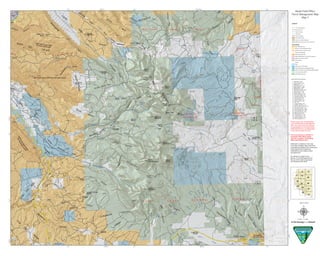
1. Negro Bill Canyon WSANo motorized access
Mill Creek Canyon WSA No motorized access
Behind
the
Rocks
W
SA
Nom
otorized
access
Hatch
Wash
Colorad
o
River
CastleCreek
Pack Creek
Mill Creek
¬«128
£¤191
")82
")82
")85
")89
")85
")85
")73
")5
")96
")85
")92
")97
")85
")73
")91
")85
")95
")84
")94
")81
")95
")234
")74
")101
")86
")371
")73
")85
")85
")95
")86
¬«46
¬«46
¬«46
¬«46
¬«46
£¤191
£¤191
£¤191
£¤191
£¤191
£¤191
£¤191
£¤191
")129
")175
")163
")174
")174
")173
")128
")162
")175
")129
")155
")164
")175
")129
")175
")130
")127
")130
")129
")175
")128
")130
")130
8500
11500
9000
7000
10000
6000
5000
6500
6000
7500
5500
6000
5500
5000
11000
6000
5000
7500
4500
4000
5000
6500
8000
4500
5000
6000
8000
7500
7000
6500
12000
11500
11000
10500
9500
7000
6500
6000
5500
9500
11000
7500
6000
5500
6000
5500
7000
6500
5000
5500
7000
5000
11000
10500
5500
9500
8000
12000
5000
8000
7500
7000
7500
11500
9000
8500
5000
7000
6500
4500
55004500
4500
4500
5500
7000
6500
7500
12500
8500
6500
7500
6500
5500
8000
7500
12000
5000
11500
12000
8000
9000
7000
7500
6500
6000
5500
11500
6000
5500
5500
6000
640,000
640,000
650,000
650,000
660,000
660,000
670,000
670,000
4,250,000
4,250,000
4,260,000
4,260,000
4,270,000
4,270,000
109°10'0"W
109°10'0"W
109°20'0"W
109°20'0"W38°30'0"N
38°30'0"N
38°20'0"N
38°20'0"N
Moab Field Office
Travel Management Map
Land Status
BLM Wilderness Area
Bureau of Land Management (BLM)
Bankhead-Jones Land Use Lands
Bureau of Reclamation
Indian Reservation (IR)
Military Reservations and Corps of Engineers
National Park Service (NPS)
Other Federal
Private
State
State Parks and Recreation
State Wildlife Reserve/Management Area
US Fish & Wildlife (USFW) National Wildlife Refuge
US Forest Service (USFS)
USFS Wilderness Area
µ0 0.55 1.1 1.65 2.20.275
Miles
1 inch = 1 mile
11
13 12
10
09
08
07 06
05
04
03
02
01
Map
Dec 4, 2014
Jeep Safari Route Numbers
1. Moab Rim = MR
2. Poison Spider = PS
3. Cliffhanger = CH
4. Sevenmile Rim = 7R
5. Metal Masher = MM
6. Steelbender = SB
7. Behind the Rocks = BR
8. Gold Bar Rim = GB
9. Golden Spike = GS
10. Hell's Revenge = HR
11. Fins and Things = FT
12. Pritchett Canyon = PC
13. Secret Spire = SS
14. Flat Iron Mesa = FI
15. Strike Ravine = SR
16. 3D = 3D
17. Copper Ridge = CR
18. Chicken Corners = CC
19. Kane Creek Canyon = KC
20. Hey Joe Canyon = HJ
21. Hell Roaring Rim = HRR
22. Rose Garden Hill = RG
23. Top of the World = TW
24. Wipeout Hill = WO
25. Porcupine Rim = PR
26. Crystal Geyser = CG
27. Dolores Triangle = DT
28. Dome Plateau = DP
Information contained in this map
is the best available data at the time
of publishing. Additions and corrections
to the data will be included as
maintainence and quality control
are performed.
No warranty is made by the
Bureau of Land Management for
the use of the data for purposes
not intended by the BLM.
Route on this map are designated
in the 2008 Resource Management
Plan. All routes not on this map are
not designated for motorized travel.
Motorized travel on non-designated
routes will be subject to fines.
No cross-country is allowed in
the Moab Field Office region
with the exception of the White
Wash Sand Dunes Area.
Text
3
Legend
ATV and Motorcycle
Motorcycle Only
Class D Roads
City Roads
County B Roads
Jeep Safari Routes
State and Federal Highways
White Wash Sand Dune Open OHV Area
")315
£¤191
UVMR