SlideShare a Scribd company logo
1 of 41
The Himalayan Rang
India is a vast country with varied landforms. Our country
has practically all major physical features of the earth i.e.
mountains, plains, deserts, plateaus and islands. India is a
large landmass formed during different geological periods
which has influenced her relief. Besides geological
formations, a number of processes such as weathering,
erosion and deposition have created and modified the relief
its present form.
Plates at our planet's surface move because of the
intense heat in the Earth's core that causes molten rock in
the mantle layer to move. It moves in a pattern called a
convection cell that forms when warm material rises, cools,
and eventually sink down. As the cooled material sinks
down, it is warmed and rises again.
The movement of the plates results in the
building up of stresses within the plates and the
continental rocks above, leading to folding,
faulting and volcanic activity.
h ' ,. ....
h
■
-
■
The tectonic plate theory describes the large scale motion
of the earth's lithosphere. This theory is based on
continental drift which explains the formation of various
continents over millions of years
Plate Boundaries:-
Based on the relative movement between two tectonic
plates, there are three types of plate boundaries.
•
•
•
•
f., •
.•
"
•
, ..
-... . ,•·
. .
• . . . A
- .... ..
- -------------------
.-
• •..,
•
"',. . . • . .
•
www.pptback.com
Ridge
D i v e r g e n t
plate
b o u n d a r y
Transform
p l a t e
b o u n d a r y
Convergent
plate
b o u n d a r y
Earthquakes
There are many hypothesis regarding the origin of Himalaya, however
there is almost a complete unanimity that the Himalayan mountains
have come out of a great geosyncline called the Tethys Sea. About 120
million years ago, there were only two big continents in the world- in
the north was Laurasia or Angaraland and in the southern hemisphere
was Gondwanaland. In between Laurasia and Gondwanaland, there
was a long, narrow and shallow sea called Tethys Sea. Sediments were
brought by the rivers from these landmasses and deposited in the bed
of the sea. These sediments were subjected to the powerful
compression force from both the continents, this compression squeezed
and crushed the sediments of Tethys and series off olds were formed
one behind the other giving rise to the highest relief features on the
earth - the Himalayas. The curved shape of the Himalayas convex to
the south, is attributed to the maximum push offered at two ends of
the Indian peninsula during its northward drift. In the northwest it
was done by the Aravalis and in the northeast by the Assam Ranges.
Recent studies shows that India is moving northward at the rate of
about 5 cm per year and crashing into rest of the Asia, buckling the
Himalayas between Angaraland and Gondwanaland. This drift is
· · . instability to the Himalayan region.
A
Rs I . N ! : r-:.s I ti 1
i-¾:£: rs
- - - - -
b e d
B rlf
a
'"""'•
I- -
i-
lt-
l pl' L
-·s::st:.,
r
.,•
:--■•
.-, k
C
....
17ic.:1!Id I I bl • I r n i t : a i"I li:!!i
a t i CII lrl • .. If -I■•I cl •►L
I 1 n t a il r l S
The Himalayas are the younqest mountains in the
world and are; structurally; the folded mountains. The
Himalayas run along the northern border of India. The
Himalayas form an arc which is about 2,400 km long. The
width varies from 400 km in Kashmir to 150 km in Arunachal
Pradesh. The altitudinal variations are greater in the eastern
part than in the western part. There are three parallel
ranges in its longitudinal extent.
1 The Great or Inner Himala as:-
This is the northernmost range and is also known as 'Himadri'. This is
the most continuous range. It contains the loftiest peaks. The average
height of peaks in this range is 6,000 meters • All the prominent
Himalayan peaks are in this range. The folds of the Great Himalayas
are asymmetrical in nature and the core of this part is composed of
granite. Because of the lofty heights, the peaks of this range are
perennially snow-bound.
2 The Lesser Himala a or Himachal:
This lies towards the south of the Great Himalayas. The altitude of
peaks in this range varies from 3,700 m to 4,SOO m. Average width of
this range is SO km. This range is mainly composed of highly
compressed and altered rocks.
3 The S iwa i s:-
This is the outermost range of the Himalayas. The altitude varies
between 900 and 1100 km in this range and the width varies between
10 to SOkm. These ranges are composed of unconsolidated
sediments. The longitudinal valleys lying between the Himachal and
Shiwaliks are called 'Dun'.
est:
Punjab Himalayas:- This part lies between the Indus and Sutlej. From
west to east, this is also known as Kashmir Himalaya and Himachal
Himalaya; respectively.
Kumaon Himalayas: This part lies between Sutlej and Kali rivers.
Nepal Himalayas: This part lies between the Kali and Tista rivers.
Assam Himalayas: This part lies between the Tista and Dihang
ri•
vers.
Eastern hills and mountains: The Brahmaputra marks the eastern
border of the Himalayas. Beyond the Dihang gorge, the Himalayas
bend sharply towards south and form the Eastern hills or Purvachal.
These hills run through the north eastern states of India. They are
mostly composed of sandstones. These hills are composed of the
Patkai Hills, Naga Hills, Manipuri Hills and Mizo Hills.
a1
•n
The northern plain of India is formed by three river systems, viz. the
Indus, the Ganga and the Brahmaputra; along with their tributaries.
This plain is composed of alluvial soil which has been deposited over
millions of years. The total area of the northern plain is about 7 lakh
square kilometer. It is about 2400 km long and about 240 to 320 km
broad
2 3
1. Punjab Plait1S
:3.Brahmaputra
Plains
The northern plain is divided into three
sections, viz. the Punjab Plain, the
a n g a Plain a n d the Brahmaputra Plain.
Puniab Plains: The Punjab plains form the western part of
the northern plain. This is formed by the Indus and its
tributaries; like Jhelum, Chenab, Ravi, Beas and Sutlej. A major
portion of this plains is in Pakistan. Doabs abound in this plain.
Ganga Plains: This plain extends between Ghaggar and Tista
rivers. The northern states, Haryana, Delhi, UP, Bihar, part of
Jharkhand and West Bengal lie in the Ganga plains.
Brahmaputra Plains: This plain forms the eastern part of the
northern plain and lies in Assam. - : : ; ; ; ,
------
Based on the relief features; the northern 1>lain can be divided
into four re$1ions, viz. bhabar, terai, bhan,s1ar and khadar.
Bhabar: After descending from the mountains, the rivers deposit
pebbles in a narrow belt. The width of this belt is about 8 to 16 km and
it lies parallel to the Shiwaliks. This region is known as bhabar. All the
streams disappear in this region.
Terai: The terai region lies towards south of the bhabar belt. In this
region, the streams reappear and make a wet, swampy and marshy
reg•
ion.
Bhangar: Bhangar is the largest part of the northern plain and is
composed of the oldest alluvial soil. They lie above the flood plains.
They resemble terraces. The soil of this region is locally known as kanka
and is composed of calcareous deposits.
Khadar: The floodplains formed by younger alluvium are called khadar.
The soil in this region is renewed every year and is thus highly fertile.
THE NORTHERN PLAINS OF INDIA
3
2
Pia e, J
3_ Clh hlo nag....,,
T e Peninsu ar P ateau
The peninsular plateau is a tableland. It is
composed of the oldest rocks because it was
formed from the drifted part of the Gondwana
land. Broad and shallow valleys and rounded
hills are the characteristic features of this
plateau.
The plateau can be broadly divided into two regions, viz.
the Central Highlands and the Deccan Plateau.
The Central Highlands: The Central Highlands lies to the north of the
Narmada river. It covers the major portion of the Malwa plateau.
The rivers in this region flow from southwest to northeast; which
indicates the slope of this region. It is wider in the west and
narrower in the east. Bundelkhand and Baghelkhand mark the
eastward extension of this plateau. The plateau further extends
eastwards into the Chhotanagpur plateau.
The Deccan Plateau:- The Deccan Plateau lies to the south of the
Naramada river. It is triangular in shape. The Satpura range makes
,itsnorthern part. The Mahadev, Kaimur Hills and Maikal range
e its eastern part. The slope of the Deccan Plateau is from
eghalaya, Karbi-Anglong Plateau and North Cachar Hills. Garo,
si and Jaintia hills are the prominent ranges; starting from
east.
The Western and the Eastern Ghats:-
They make the western and eastern edges of the
Deccan Plateau. The average elevation of Western
Ghats is 900-1600 metres; compared to 600 metres in
case of Eastern Ghats. The Eastern Ghats stretch from
Mahanadi Valley to the Nilgiris in the south. The
Western Ghats cause oceanographic rains as they face
the rain-laden winds from west.
/
1
•
,.
•
-
..
•
•
- •
•
..
,
■ he .....reat In ian esert
also nown as t e ar
Desert , is a ar e, a1ni
re ion int e northwester;n
art o t e n ian
su continent.
• ith an area o more
han 0,0 0 s . m.
■ It is the won d's th ar est
su tro ica desert.
The Indian desert lies towards the western
margins of the Aravali Hills. This region
gets scanty rainfall which is less than 150
mm in a year. Hence they climate is arid
and vegetation is scanty. Luni is the only
large river but some streams appear
during rainy season. Crescent-shaped
dunes barchans abound in this area.
1
•
T e Coasta P ains
• .i' f[he Peninsular plateau is flanked by stretch of
'
i., narrow coastal strips. They run along the Arabian Sea
on the west and along the Bay of Bengal on the east.
The western coast lies between the Western Ghats
nd the Arabian Sea. It is divided into three sections.
The Konkan; which comprises of Mumbai and Goa
makes the northern part. The Kannada Plain makes
the central pat and the Malabar coast makes the
Malabara coast.
The western coastal plain is wider and level and it
runs along the Bay of Bengal. It is divided into two
parts. The northern part is called Northern Circar. The
southern part is called the Coromandel Coast.
Extensive deltas are formed by large rivers like
Mahanadi, Godavari and Kavery. Chilika lake is an
important feature along the eastern coast
THE COASTAL PLAINS
-
•
su - c o n 1nen a
s u r r o u n e .,
•
1ece o
an I a
a e
r
.
The Lakshadweep Islands are in the
Arabian Sea. Its area is 32 sq km. The
administrative headquarters of Lakshadweep
is at Kavaratti island. This group of islands is
rich in terms of biodiversity.
The Andaman and Nicobar Islands are
bigger in size and has more number of
islands. This group of islands can be divided
into two groups. The Andaman is in the
north and the Nicobar is in the south. These
islands too have rich biodiversity.
■ ese island ·rou: s a
r
e o·
reat economic and strate_ ic
im ortance for the count .
ou ism otential.
- ecurity.
- T r a e .
lin .
a natura
-A r m s s m u
- · m
u · i
n o
resources
antral on Indian cean.
: : I I . . - - - -
• T h e r e a r e 3 6 c o r a l i s l a n d s t h a t c o n s t i t u t e
L a k s h a d w e e p i s l a n d s , o n l y 1 0 a r e i n h a b i t e d
t o u r i s r i f , _
a n d o n l y s i x h a v e b e e n o p e n e d f o r
• T h e i r t o t a l l a n d a r e a i s 3 2 k r , , 2
. .
• T h e s e i s l a n d s , f o 1 1 r r 1 e d o f c o r a l d e p o s i t s , a r e
c a l l e d a t o l l s _ A t o l l s a r e c i r c u l a r o r h o r s e
s h o e s h a p e d c o r a l r e e f s .
•
- l < a r a v a t t i i s t h e a d t " l " l i n i s t r a t i v e h e a d q u a r t e r : : ; o f
L a k s h a d w e e p I s l a n d s _
- , h i s i s l a n d g r o u p h a s g r e a t d i v e r ! ; i t y o f f l o r a
a n d f a u n a .
[Slideshare-Downloader-la]-649a802f32a57.pptx
[Slideshare-Downloader-la]-649a802f32a57.pptx
[Slideshare-Downloader-la]-649a802f32a57.pptx

More Related Content

What's hot

Food Processing Tools, Equipment and Utensils (2).pptx
Food Processing Tools, Equipment and Utensils (2).pptxFood Processing Tools, Equipment and Utensils (2).pptx
Food Processing Tools, Equipment and Utensils (2).pptx
ReginaCalamba2
 
Appetizer, vegetable dish, dessert, fish dish, meat dish recipe
Appetizer, vegetable dish, dessert, fish dish, meat dish recipeAppetizer, vegetable dish, dessert, fish dish, meat dish recipe
Appetizer, vegetable dish, dessert, fish dish, meat dish recipe
Ners Iraola
 

What's hot (20)

Carving
CarvingCarving
Carving
 
Food Processing Tools, Equipment and Utensils (2).pptx
Food Processing Tools, Equipment and Utensils (2).pptxFood Processing Tools, Equipment and Utensils (2).pptx
Food Processing Tools, Equipment and Utensils (2).pptx
 
ACCOMPANIMENT OF APPETIZERS L4.pptx
ACCOMPANIMENT OF APPETIZERS L4.pptxACCOMPANIMENT OF APPETIZERS L4.pptx
ACCOMPANIMENT OF APPETIZERS L4.pptx
 
Tools and equipment
Tools and equipmentTools and equipment
Tools and equipment
 
Cuisine of the usa
Cuisine of the usaCuisine of the usa
Cuisine of the usa
 
Classification of appetizers
Classification of appetizersClassification of appetizers
Classification of appetizers
 
Interpret Kitchen Layout.pptx.pdf
Interpret Kitchen Layout.pptx.pdfInterpret Kitchen Layout.pptx.pdf
Interpret Kitchen Layout.pptx.pdf
 
Plating and presentation
Plating and presentationPlating and presentation
Plating and presentation
 
Variety of hot or cold appetizer
Variety of hot or cold appetizerVariety of hot or cold appetizer
Variety of hot or cold appetizer
 
Unit 3 lesson 4a soil 1
Unit 3 lesson 4a soil 1Unit 3 lesson 4a soil 1
Unit 3 lesson 4a soil 1
 
PREPARE APPETIZERS.pptx
PREPARE APPETIZERS.pptxPREPARE APPETIZERS.pptx
PREPARE APPETIZERS.pptx
 
Appetizer, vegetable dish, dessert, fish dish, meat dish recipe
Appetizer, vegetable dish, dessert, fish dish, meat dish recipeAppetizer, vegetable dish, dessert, fish dish, meat dish recipe
Appetizer, vegetable dish, dessert, fish dish, meat dish recipe
 
Characteristics of soils
Characteristics of soilsCharacteristics of soils
Characteristics of soils
 
Growing Ornamental Plants
Growing Ornamental PlantsGrowing Ornamental Plants
Growing Ornamental Plants
 
Soil and it’s types in india
Soil and it’s types in indiaSoil and it’s types in india
Soil and it’s types in india
 
Classification of appetizer
Classification of appetizerClassification of appetizer
Classification of appetizer
 
Variety of hot or cold appetizer
Variety of hot or cold appetizerVariety of hot or cold appetizer
Variety of hot or cold appetizer
 
Flower arrangement
Flower arrangementFlower arrangement
Flower arrangement
 
Cooking methods
Cooking methodsCooking methods
Cooking methods
 
COOKERY 9 WEEK 1 CLEAN SANITIZE AND STORE KITCHEN TOOLS AND EQUIPMENT.pdf
COOKERY 9 WEEK 1 CLEAN SANITIZE AND STORE KITCHEN TOOLS AND EQUIPMENT.pdfCOOKERY 9 WEEK 1 CLEAN SANITIZE AND STORE KITCHEN TOOLS AND EQUIPMENT.pdf
COOKERY 9 WEEK 1 CLEAN SANITIZE AND STORE KITCHEN TOOLS AND EQUIPMENT.pdf
 

Similar to [Slideshare-Downloader-la]-649a802f32a57.pptx

Physical features of india
Physical features of indiaPhysical features of india
Physical features of india
Uday Pal
 
Physical features of india
Physical features of indiaPhysical features of india
Physical features of india
Uday Pal
 

Similar to [Slideshare-Downloader-la]-649a802f32a57.pptx (20)

Sst ppt on physical features of india
Sst ppt on physical features of indiaSst ppt on physical features of india
Sst ppt on physical features of india
 
Sstppt
SstpptSstppt
Sstppt
 
PRESENTATION_ON_PHYSICAL_DIVISIONS_OF_IN.pptx
PRESENTATION_ON_PHYSICAL_DIVISIONS_OF_IN.pptxPRESENTATION_ON_PHYSICAL_DIVISIONS_OF_IN.pptx
PRESENTATION_ON_PHYSICAL_DIVISIONS_OF_IN.pptx
 
Ch.2 Physical Features of India
Ch.2 Physical Features of India Ch.2 Physical Features of India
Ch.2 Physical Features of India
 
Physical features of india
Physical features of indiaPhysical features of india
Physical features of india
 
Ch.2 Physical Features of India
Ch.2 Physical Features of India Ch.2 Physical Features of India
Ch.2 Physical Features of India
 
Physical features of india
Physical features of indiaPhysical features of india
Physical features of india
 
Physical features -Grade 9
Physical features -Grade 9Physical features -Grade 9
Physical features -Grade 9
 
Physical features of india
Physical features of indiaPhysical features of india
Physical features of india
 
Physical feature of india.ppt
Physical feature of india.pptPhysical feature of india.ppt
Physical feature of india.ppt
 
Physical features of india
Physical features of indiaPhysical features of india
Physical features of india
 
Physical feature of india by ayush dewangan 😘.pptx
Physical feature of india by ayush dewangan 😘.pptxPhysical feature of india by ayush dewangan 😘.pptx
Physical feature of india by ayush dewangan 😘.pptx
 
Physical features of india
Physical features of indiaPhysical features of india
Physical features of india
 
Physical features of india
Physical features of indiaPhysical features of india
Physical features of india
 
Physical features of india
Physical features of indiaPhysical features of india
Physical features of india
 
chp 2 class 9.pdf
chp 2 class 9.pdfchp 2 class 9.pdf
chp 2 class 9.pdf
 
Social science power point presentaion.
Social science power point presentaion.Social science power point presentaion.
Social science power point presentaion.
 
Physical features of india
Physical features of indiaPhysical features of india
Physical features of india
 
Physical features of india
Physical features of indiaPhysical features of india
Physical features of india
 
Ppt on Features of india
Ppt on Features of indiaPpt on Features of india
Ppt on Features of india
 

Recently uploaded

Call Girls in Uttam Nagar (delhi) call me [🔝9953056974🔝] escort service 24X7
Call Girls in  Uttam Nagar (delhi) call me [🔝9953056974🔝] escort service 24X7Call Girls in  Uttam Nagar (delhi) call me [🔝9953056974🔝] escort service 24X7
Call Girls in Uttam Nagar (delhi) call me [🔝9953056974🔝] escort service 24X7
9953056974 Low Rate Call Girls In Saket, Delhi NCR
 

Recently uploaded (20)

Python Notes for mca i year students osmania university.docx
Python Notes for mca i year students osmania university.docxPython Notes for mca i year students osmania university.docx
Python Notes for mca i year students osmania university.docx
 
Tatlong Kwento ni Lola basyang-1.pdf arts
Tatlong Kwento ni Lola basyang-1.pdf artsTatlong Kwento ni Lola basyang-1.pdf arts
Tatlong Kwento ni Lola basyang-1.pdf arts
 
Call Girls in Uttam Nagar (delhi) call me [🔝9953056974🔝] escort service 24X7
Call Girls in  Uttam Nagar (delhi) call me [🔝9953056974🔝] escort service 24X7Call Girls in  Uttam Nagar (delhi) call me [🔝9953056974🔝] escort service 24X7
Call Girls in Uttam Nagar (delhi) call me [🔝9953056974🔝] escort service 24X7
 
Graduate Outcomes Presentation Slides - English
Graduate Outcomes Presentation Slides - EnglishGraduate Outcomes Presentation Slides - English
Graduate Outcomes Presentation Slides - English
 
Exploring_the_Narrative_Style_of_Amitav_Ghoshs_Gun_Island.pptx
Exploring_the_Narrative_Style_of_Amitav_Ghoshs_Gun_Island.pptxExploring_the_Narrative_Style_of_Amitav_Ghoshs_Gun_Island.pptx
Exploring_the_Narrative_Style_of_Amitav_Ghoshs_Gun_Island.pptx
 
Interdisciplinary_Insights_Data_Collection_Methods.pptx
Interdisciplinary_Insights_Data_Collection_Methods.pptxInterdisciplinary_Insights_Data_Collection_Methods.pptx
Interdisciplinary_Insights_Data_Collection_Methods.pptx
 
How to Manage Global Discount in Odoo 17 POS
How to Manage Global Discount in Odoo 17 POSHow to Manage Global Discount in Odoo 17 POS
How to Manage Global Discount in Odoo 17 POS
 
How to Add a Tool Tip to a Field in Odoo 17
How to Add a Tool Tip to a Field in Odoo 17How to Add a Tool Tip to a Field in Odoo 17
How to Add a Tool Tip to a Field in Odoo 17
 
Single or Multiple melodic lines structure
Single or Multiple melodic lines structureSingle or Multiple melodic lines structure
Single or Multiple melodic lines structure
 
HMCS Max Bernays Pre-Deployment Brief (May 2024).pptx
HMCS Max Bernays Pre-Deployment Brief (May 2024).pptxHMCS Max Bernays Pre-Deployment Brief (May 2024).pptx
HMCS Max Bernays Pre-Deployment Brief (May 2024).pptx
 
Understanding Accommodations and Modifications
Understanding  Accommodations and ModificationsUnderstanding  Accommodations and Modifications
Understanding Accommodations and Modifications
 
Sensory_Experience_and_Emotional_Resonance_in_Gabriel_Okaras_The_Piano_and_Th...
Sensory_Experience_and_Emotional_Resonance_in_Gabriel_Okaras_The_Piano_and_Th...Sensory_Experience_and_Emotional_Resonance_in_Gabriel_Okaras_The_Piano_and_Th...
Sensory_Experience_and_Emotional_Resonance_in_Gabriel_Okaras_The_Piano_and_Th...
 
SOC 101 Demonstration of Learning Presentation
SOC 101 Demonstration of Learning PresentationSOC 101 Demonstration of Learning Presentation
SOC 101 Demonstration of Learning Presentation
 
FICTIONAL SALESMAN/SALESMAN SNSW 2024.pdf
FICTIONAL SALESMAN/SALESMAN SNSW 2024.pdfFICTIONAL SALESMAN/SALESMAN SNSW 2024.pdf
FICTIONAL SALESMAN/SALESMAN SNSW 2024.pdf
 
General Principles of Intellectual Property: Concepts of Intellectual Proper...
General Principles of Intellectual Property: Concepts of Intellectual  Proper...General Principles of Intellectual Property: Concepts of Intellectual  Proper...
General Principles of Intellectual Property: Concepts of Intellectual Proper...
 
How to Create and Manage Wizard in Odoo 17
How to Create and Manage Wizard in Odoo 17How to Create and Manage Wizard in Odoo 17
How to Create and Manage Wizard in Odoo 17
 
Jamworks pilot and AI at Jisc (20/03/2024)
Jamworks pilot and AI at Jisc (20/03/2024)Jamworks pilot and AI at Jisc (20/03/2024)
Jamworks pilot and AI at Jisc (20/03/2024)
 
Food safety_Challenges food safety laboratories_.pdf
Food safety_Challenges food safety laboratories_.pdfFood safety_Challenges food safety laboratories_.pdf
Food safety_Challenges food safety laboratories_.pdf
 
FSB Advising Checklist - Orientation 2024
FSB Advising Checklist - Orientation 2024FSB Advising Checklist - Orientation 2024
FSB Advising Checklist - Orientation 2024
 
Beyond_Borders_Understanding_Anime_and_Manga_Fandom_A_Comprehensive_Audience_...
Beyond_Borders_Understanding_Anime_and_Manga_Fandom_A_Comprehensive_Audience_...Beyond_Borders_Understanding_Anime_and_Manga_Fandom_A_Comprehensive_Audience_...
Beyond_Borders_Understanding_Anime_and_Manga_Fandom_A_Comprehensive_Audience_...
 

[Slideshare-Downloader-la]-649a802f32a57.pptx

  • 2.
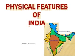
  • 3. India is a vast country with varied landforms. Our country has practically all major physical features of the earth i.e. mountains, plains, deserts, plateaus and islands. India is a large landmass formed during different geological periods which has influenced her relief. Besides geological formations, a number of processes such as weathering, erosion and deposition have created and modified the relief its present form.
  • 4. Plates at our planet's surface move because of the intense heat in the Earth's core that causes molten rock in the mantle layer to move. It moves in a pattern called a convection cell that forms when warm material rises, cools, and eventually sink down. As the cooled material sinks down, it is warmed and rises again. The movement of the plates results in the building up of stresses within the plates and the continental rocks above, leading to folding, faulting and volcanic activity. h ' ,. .... h
  • 5. ■ - ■ The tectonic plate theory describes the large scale motion of the earth's lithosphere. This theory is based on continental drift which explains the formation of various continents over millions of years Plate Boundaries:- Based on the relative movement between two tectonic plates, there are three types of plate boundaries. • • • • f., • .• " • , .. -... . ,•· . . • . . . A - .... .. - ------------------- .- • •.., • "',. . . • . . • www.pptback.com
  • 6.
  • 7. Ridge D i v e r g e n t plate b o u n d a r y Transform p l a t e b o u n d a r y Convergent plate b o u n d a r y Earthquakes
  • 8. There are many hypothesis regarding the origin of Himalaya, however there is almost a complete unanimity that the Himalayan mountains have come out of a great geosyncline called the Tethys Sea. About 120 million years ago, there were only two big continents in the world- in the north was Laurasia or Angaraland and in the southern hemisphere was Gondwanaland. In between Laurasia and Gondwanaland, there was a long, narrow and shallow sea called Tethys Sea. Sediments were brought by the rivers from these landmasses and deposited in the bed of the sea. These sediments were subjected to the powerful compression force from both the continents, this compression squeezed and crushed the sediments of Tethys and series off olds were formed one behind the other giving rise to the highest relief features on the earth - the Himalayas. The curved shape of the Himalayas convex to the south, is attributed to the maximum push offered at two ends of the Indian peninsula during its northward drift. In the northwest it was done by the Aravalis and in the northeast by the Assam Ranges. Recent studies shows that India is moving northward at the rate of about 5 cm per year and crashing into rest of the Asia, buckling the Himalayas between Angaraland and Gondwanaland. This drift is · · . instability to the Himalayan region.
  • 9. A Rs I . N ! : r-:.s I ti 1 i-¾:£: rs - - - - - b e d B rlf a '"""'• I- - i- lt- l pl' L -·s::st:., r .,• :--■• .-, k C .... 17ic.:1!Id I I bl • I r n i t : a i"I li:!!i a t i CII lrl • .. If -I■•I cl •►L I 1 n t a il r l S
  • 10.
  • 11. The Himalayas are the younqest mountains in the world and are; structurally; the folded mountains. The Himalayas run along the northern border of India. The Himalayas form an arc which is about 2,400 km long. The width varies from 400 km in Kashmir to 150 km in Arunachal Pradesh. The altitudinal variations are greater in the eastern part than in the western part. There are three parallel ranges in its longitudinal extent.
  • 12.
  • 13. 1 The Great or Inner Himala as:- This is the northernmost range and is also known as 'Himadri'. This is the most continuous range. It contains the loftiest peaks. The average height of peaks in this range is 6,000 meters • All the prominent Himalayan peaks are in this range. The folds of the Great Himalayas are asymmetrical in nature and the core of this part is composed of granite. Because of the lofty heights, the peaks of this range are perennially snow-bound. 2 The Lesser Himala a or Himachal: This lies towards the south of the Great Himalayas. The altitude of peaks in this range varies from 3,700 m to 4,SOO m. Average width of this range is SO km. This range is mainly composed of highly compressed and altered rocks. 3 The S iwa i s:- This is the outermost range of the Himalayas. The altitude varies between 900 and 1100 km in this range and the width varies between 10 to SOkm. These ranges are composed of unconsolidated sediments. The longitudinal valleys lying between the Himachal and Shiwaliks are called 'Dun'.
  • 14. est: Punjab Himalayas:- This part lies between the Indus and Sutlej. From west to east, this is also known as Kashmir Himalaya and Himachal Himalaya; respectively. Kumaon Himalayas: This part lies between Sutlej and Kali rivers. Nepal Himalayas: This part lies between the Kali and Tista rivers. Assam Himalayas: This part lies between the Tista and Dihang ri• vers. Eastern hills and mountains: The Brahmaputra marks the eastern border of the Himalayas. Beyond the Dihang gorge, the Himalayas bend sharply towards south and form the Eastern hills or Purvachal. These hills run through the north eastern states of India. They are mostly composed of sandstones. These hills are composed of the Patkai Hills, Naga Hills, Manipuri Hills and Mizo Hills.
  • 15.
  • 16.
  • 17. a1 •n The northern plain of India is formed by three river systems, viz. the Indus, the Ganga and the Brahmaputra; along with their tributaries. This plain is composed of alluvial soil which has been deposited over millions of years. The total area of the northern plain is about 7 lakh square kilometer. It is about 2400 km long and about 240 to 320 km broad 2 3 1. Punjab Plait1S :3.Brahmaputra Plains
  • 18. The northern plain is divided into three sections, viz. the Punjab Plain, the a n g a Plain a n d the Brahmaputra Plain. Puniab Plains: The Punjab plains form the western part of the northern plain. This is formed by the Indus and its tributaries; like Jhelum, Chenab, Ravi, Beas and Sutlej. A major portion of this plains is in Pakistan. Doabs abound in this plain. Ganga Plains: This plain extends between Ghaggar and Tista rivers. The northern states, Haryana, Delhi, UP, Bihar, part of Jharkhand and West Bengal lie in the Ganga plains. Brahmaputra Plains: This plain forms the eastern part of the northern plain and lies in Assam. - : : ; ; ; , ------
  • 19. Based on the relief features; the northern 1>lain can be divided into four re$1ions, viz. bhabar, terai, bhan,s1ar and khadar. Bhabar: After descending from the mountains, the rivers deposit pebbles in a narrow belt. The width of this belt is about 8 to 16 km and it lies parallel to the Shiwaliks. This region is known as bhabar. All the streams disappear in this region. Terai: The terai region lies towards south of the bhabar belt. In this region, the streams reappear and make a wet, swampy and marshy reg• ion. Bhangar: Bhangar is the largest part of the northern plain and is composed of the oldest alluvial soil. They lie above the flood plains. They resemble terraces. The soil of this region is locally known as kanka and is composed of calcareous deposits. Khadar: The floodplains formed by younger alluvium are called khadar. The soil in this region is renewed every year and is thus highly fertile.
  • 21.
  • 22. 3 2 Pia e, J 3_ Clh hlo nag....,,
  • 23. T e Peninsu ar P ateau The peninsular plateau is a tableland. It is composed of the oldest rocks because it was formed from the drifted part of the Gondwana land. Broad and shallow valleys and rounded hills are the characteristic features of this plateau.
  • 24. The plateau can be broadly divided into two regions, viz. the Central Highlands and the Deccan Plateau. The Central Highlands: The Central Highlands lies to the north of the Narmada river. It covers the major portion of the Malwa plateau. The rivers in this region flow from southwest to northeast; which indicates the slope of this region. It is wider in the west and narrower in the east. Bundelkhand and Baghelkhand mark the eastward extension of this plateau. The plateau further extends eastwards into the Chhotanagpur plateau. The Deccan Plateau:- The Deccan Plateau lies to the south of the Naramada river. It is triangular in shape. The Satpura range makes ,itsnorthern part. The Mahadev, Kaimur Hills and Maikal range e its eastern part. The slope of the Deccan Plateau is from eghalaya, Karbi-Anglong Plateau and North Cachar Hills. Garo, si and Jaintia hills are the prominent ranges; starting from east.
  • 25. The Western and the Eastern Ghats:- They make the western and eastern edges of the Deccan Plateau. The average elevation of Western Ghats is 900-1600 metres; compared to 600 metres in case of Eastern Ghats. The Eastern Ghats stretch from Mahanadi Valley to the Nilgiris in the south. The Western Ghats cause oceanographic rains as they face the rain-laden winds from west. /
  • 26.
  • 28. ■ he .....reat In ian esert also nown as t e ar Desert , is a ar e, a1ni re ion int e northwester;n art o t e n ian su continent. • ith an area o more han 0,0 0 s . m. ■ It is the won d's th ar est su tro ica desert.
  • 29. The Indian desert lies towards the western margins of the Aravali Hills. This region gets scanty rainfall which is less than 150 mm in a year. Hence they climate is arid and vegetation is scanty. Luni is the only large river but some streams appear during rainy season. Crescent-shaped dunes barchans abound in this area.
  • 30.
  • 31.
  • 32. 1 • T e Coasta P ains • .i' f[he Peninsular plateau is flanked by stretch of ' i., narrow coastal strips. They run along the Arabian Sea on the west and along the Bay of Bengal on the east. The western coast lies between the Western Ghats nd the Arabian Sea. It is divided into three sections. The Konkan; which comprises of Mumbai and Goa makes the northern part. The Kannada Plain makes the central pat and the Malabar coast makes the Malabara coast. The western coastal plain is wider and level and it runs along the Bay of Bengal. It is divided into two parts. The northern part is called Northern Circar. The southern part is called the Coromandel Coast. Extensive deltas are formed by large rivers like Mahanadi, Godavari and Kavery. Chilika lake is an important feature along the eastern coast
  • 34. -
  • 35. • su - c o n 1nen a s u r r o u n e ., • 1ece o an I a a e r .
  • 36. The Lakshadweep Islands are in the Arabian Sea. Its area is 32 sq km. The administrative headquarters of Lakshadweep is at Kavaratti island. This group of islands is rich in terms of biodiversity. The Andaman and Nicobar Islands are bigger in size and has more number of islands. This group of islands can be divided into two groups. The Andaman is in the north and the Nicobar is in the south. These islands too have rich biodiversity.
  • 37. ■ ese island ·rou: s a r e o· reat economic and strate_ ic im ortance for the count . ou ism otential. - ecurity. - T r a e . lin . a natura -A r m s s m u - · m u · i n o resources antral on Indian cean. : : I I . . - - - -
  • 38. • T h e r e a r e 3 6 c o r a l i s l a n d s t h a t c o n s t i t u t e L a k s h a d w e e p i s l a n d s , o n l y 1 0 a r e i n h a b i t e d t o u r i s r i f , _ a n d o n l y s i x h a v e b e e n o p e n e d f o r • T h e i r t o t a l l a n d a r e a i s 3 2 k r , , 2 . . • T h e s e i s l a n d s , f o 1 1 r r 1 e d o f c o r a l d e p o s i t s , a r e c a l l e d a t o l l s _ A t o l l s a r e c i r c u l a r o r h o r s e s h o e s h a p e d c o r a l r e e f s . • - l < a r a v a t t i i s t h e a d t " l " l i n i s t r a t i v e h e a d q u a r t e r : : ; o f L a k s h a d w e e p I s l a n d s _ - , h i s i s l a n d g r o u p h a s g r e a t d i v e r ! ; i t y o f f l o r a a n d f a u n a .