More Related Content
Similar to Hoh River Characteristics
Similar to Hoh River Characteristics (20)
Hoh River Characteristics
- 1. Braided Canyon
Confined
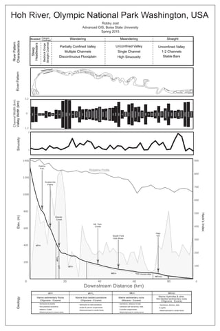
Wandering Meandering Straight
Steep
Headwaters
RiverPattern
Characteristics
BedrockGorge
StraightChannel Partially Confined Valley
Multiple Channels
Discontinuous Floodplain
Unconfined Valley
Single Channel
High Sinuousity
Unconfined Valley
1-2 Channels
Stable Bars
2
1
SinuosityValleyWidth(km)
1.2
0
1.2
Debris
Fan
Hwy
101
0
100
200
300
400
500
600
700
800
900
200
400
600
800
1000
1200
1400
0 20 40 60 80
Elev.(m)
Downstream Distance (km)
Mt. Tom
Creek
MEm(r)
Fault, unknown offset
Hack’sIndex
Avalanche
Paths
South Fork
Hoh River
Glacier
Creek
MEmφEmst
φEmst
φEm
RiverPattern
- Semischist & phyllite
- Recrystallized sandstone,
siltstone, & slate
- Metamorphosed to zeolite facies
Marine sedimentarty Rocks
(Oligocene - Eocene)
Marine thick-bedded sandstone
(Oligocene - Eocene)
- Semischist & meta-sandstone
- phylite & granule conglomerate
- Metamorphosed to zeolite facies
Marine sedimentary rocks
(Miocene - Eocene)
- Sandstone, siltstone, & slate
- Interlaced with semischist, slate,
& phyllite conglomerate
- Metamorphosed to zeolite facies
Marine rhythmites & other
thin-bedded sedimentary rocks
(Oligocene - Eocene)
- Sandstone, siltstone, slate,
& argillite
- Metamorphosed to zeolite facies
Hoh River, Olympic National Park Washington, USA
Robby Jost
Advanced GIS, Boise State University
Spring 2015
φEm
φEm
MEm
MEm(r)
Ridgeline Profile
Geology
ChannelWidth(km)