
Recommended
More Related Content
What's hot
Similar to Miri to Kota Kinabalu Roadmap with 10 Immigration Checkpoints
Similar to Miri to Kota Kinabalu Roadmap with 10 Immigration Checkpoints (8)
Recently uploaded
Recently uploaded (20)
Miri to Kota Kinabalu Roadmap with 10 Immigration Checkpoints
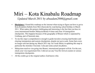
- 1. Miri – Kota Kinabalu Roadmap Updated March 2011 by abuadam2006@gmail.com • Disclaimer: I found this roadmap on the internet when trying to figure out how to get to Kota Kinabalu (Sabah) from Miri (Sarawak) by road during school holiday in March 2011. What makes this project challenging and interesting is the fact that you have to cross international borders Malaysia/Brunei 4 times and clear 10 immigration checkpoints. This happens because of the geography of Brunei which is separated by Limbang, part of Sarawak state. • To me this map is comprehensive enough to guide travelers crossing land borders and clearing immigration and custom checkpoints, despite not up to scale. Some facts were no longer relevant during my March 2011 trip. So I took liberty in updating this map in particular the stretches I traveled. I also put some actual site photos. • Malaysians need no visa going into Brunei, international passport will do. For the rest, check your visa requirement first. I did not see any Visa On Arrival counter at various immigration checkpoints. • All the credits go to the original author, God knows who.
- 2. BINTULU- MIRI ROUTE Miri Pujut Town To Miri Airport Traffic Light From Bintulu To Miri Town To Miri Hospital Bomba Miri To Miri Bus Station Pujut Bulatan Sarawak Shell Round About G.K Super Market To Sarawak Shell Office Permy Jaya Round About SESCO Perumahan Permy Jaya Miri Go- Kart Racing Track IKBN Miri S.K Merbau Tol Jambatan Sin Yang RM 10/- To Kuala Baram Sarawak Boarder A Legend: The red color arrow is the way you should follow. To Lutong / Kuala Baram
- 3. JERUDONG HIGHWAY TO BANDAR SERI BEGAWAN TO TUTONG KUALA BELAIT ROUTE SUBSTATION Transmission tower Anduki Anduki Seria SeaView hotel & supermarket Mumong roundabout Teapot K.B. Sg. Belait km 49 Rasau Bridge toll (BR. 3/-) km 47.8 km 60 km 91.2 km 94 km 101 km 107 To Lamunin / Tasek Merinbun km 109 milestone 5 km to Lamunin Water pipes Overhead ironbar Sungai Tujuh From checkpoint white sands To Lamunin Sg. Telamba km 76.8 B TWO OPTIONS to go Kuala Lurah from Kuala Belait. 1) HIGHWAY TO JERUDUNG PARK. REFER PG 3 2) SMALL ROAD VIA LAMUNIN Note: The simplest is Option 1 as you drive all the way on the highway until Jerudong. If you like adventure and like to see how average Bruneians live, take criss-cross roads cutting villages. During my March2011 trip, road - after turning right to Sg Mitus Kecil - was under construction, but still passable by compact car. Shell Station Grocery Shop A U turn Simpang to Tanjung Maya Legend: The red color arrow is the way you should follow.
- 4. Sg. Matasan Overhead ironbar milestone 38 km to BSB Kilang papan SRK Kiudang Tutong Sg. Simut SRK Batang Mitus tower To Tutong / Bandar SB Jln Batang Mitus Kecil Simpang 128 km 121 km 119 signboard Kpg. Padnunok Kpg. Kiudang Simpang 302 km 123 kedai gunting Restoran Zaini Jinah & km 124 Gravel road km 125 Simpang 264 km 127 B C WATER PIPES ROUTE March2011: kilang papan and tower not sighted. May be gone already. Slow down after you see signboard as the road turning right to Jln Batang Mitus is narrow and unmarked. You can easily miss this turn. Legend: The red color arrow is the way you should follow. signboard Kuala Lurah / Jln Bebuloh (Turn left to K. Lurah) March2011: Road under contruction here
- 5. SHOPS FROM KB TUTONG JUNCTION TRAFFIC LIGHT JERUDONG HIGHWAY TO MUARA JJEERRUUDDOONNGG PPAARRKK TTUUTTOONNGG TTOOWWNN TO BANDAR SERI BEGAWAN TRAFFIC LIGHT SHOPS MOSQUE 16 km PARKING LOTS MOSQUE 3KM SHELL PETROL STN. JERUDONG TRAFFIC LIGHT CHILDERN PLAYGROUND To Kuala Lurah Immigration TAKE TURN ON YOUR LEFT CRYSTAL TOWER ROUNDABOUT TO MUARA PARK’S OVERHEAD BRIDGE Warning! Slow down. Turn on the left is about 50-80 meters after sign board. No other signs after this! ENLARGED MAP BRUNEI - LIMBANG ROUTE SEE ENLARGED MAP TO BSB Balai Polis Sg. Tajau ( Brunei ) Jalan Kuala Lurah Jalan Melaut km 129 km 130 tower C D Legend: The red color arrow is the way you should follow. Padi field here! Sekolah Vokasional This road takes you to BBS via Jln Tutong eventually 1KM
- 6. Sugar Bun km 160 Sg. Lubai BBRRUUNNEEII LIMBANG TOWN CENTER ((KKuuaallaa LLuurruuhh) SSAARRAAWWAAKK -MMAALLAAYYSSIIAA (TTeedduunnggaann) km 133 IMMIGRATION & CUSTOM CHECK POINTS To LIMBANG TOWN - 42KM TO TEDUNGAN KUALA LURUH LAKU LIMBANG RIVER Water Dept. March2011: IMMIGRATION & CUSTOM CHECK POINT moved to a new complex just before Puni river. Previously located here. NO NEED TO STOP HERE NOW. Go straight up to Puni river crossing. WET MARKET SHOPS TAXI STAND SHOPPING PLAZA HOTEL ZEBRA CROSSING TO FERRY POINT-TEMBURONG LIMBANG AREA ROUTE SHOPS Note - Not all bridges are shown on this map. border Long queues normally occur during weekends (Fri-Sun) and during holidays. may take 1hr - 3hrs to cross each side. km 152 km 164 Jalan Batu Danau MULTI STOREY CAR PARK Limbang Airport Indoor stadium Hospital Telekom Limbang km 174 km 152 To Nangka Mendamit Batu Danau Sg. Limbang D E LEGEND IMMIGRATION & CUSTOM (CAR) CHECK IN & CHECK OUT POINTS. EX Limbang airport To Limbang New airport Legend: The red color arrow is the way you should follow. New Malaysian border checkpoint almost completed (March2011) Jabatan Penjara
- 7. FROM LIMBANG FERRY RM 8/- or B$4 Temburong River PUNI LABU ROAD 4 km GO STRAIGHT DO NOT TURN (Pos Kawalan Immigresen Puni - 600 metres from ferry). WARNING! TRAFFIC SPEED TRAP! 65KM LIMIT BRUNEI CUSTOM & IMMIGRATION CHECK POINT (Labu checkpoint) To Sundar Awat Awat To Lawas town – 19 km SLOW DOWN here !! Steep ramp TRUSAN RIVER BANGAR TRUSAN DISTRICT TEMBURONG DISTRICT ROUTE LEGEND IMMIGRATION & CUSTOM (CAR) CHECK IN & CHECK OUT POINTS. March2011: New Malaysia border CHECK POINT (Mengkalap checkpoint). Previously located next to Trusan bazar. Border Malaysia Brunei Border Brunei Malaysia Wooden house Sg. Pandanunan Temburong town Trusan bazaar Dewan masyarakat E F Legend: The red color arrow is the way you should follow. March2011: Previously there was a ferry crossing the Trusan River, now replaced with a concrete bridge. Mosque (next to checkpoint) March2011: New Malaysia border checkpoint at Pandaruan just before you come to Puni river SR Puni
- 8. IMMIGRATION CABIN APPROX. @ 13.30HRS EXPRESS BOAT FROM BRUNEI LAWAS TOWN ROUTE from Trusan SHOPS SHOPS SHOPS SHOPS SHOPS TO MERAPOK & SINDUMIN (SABAH) 35KM RIVER JUNGLE PRODUCT MARKET JALAN LAWAS DAMIT CUSTOM BLDG. EXPRESS BOATS LANDING RIVER SUGAR BUN TOWN CENTER Jalan Gaya Jalan Merapok Lawas Damit Jalan Punang Jalan Trusan Batang Lawas suspension petrol station Methodist Church ?? to Long Tuma Bridge (single lane) F Lawas G Airport Head office immigration office lawas Fire station lawas Legend: The red color arrow is the way you should follow.
- 9. MERAPOK - SINDUMIN FROM LAW AS MERAPOK SARAWAK SABAH IMMIGRATION OFFICE POLICE IMMIGRATION CHECK OFFICE SINDUMIN TO SIPITANG - 18 KM BEAUFORT - 65 KM PAPAR KOTA KINABALU - 162 KM Sarawak passport holders need not check in at the borders between Sarawak & Sabah! MERAPOK – SIDUMIN SIPITANG ROUTE stalls Balai Polis Mosque G New immigration office merapok Bridge (sg Mengalong) Petronas station H Shop lot KG Pantai To SFI Camp Grocery Shop Sekolah Padang Berampah To Kilang Kertas SFI Perumahan Sekolah Pekan Shop lot Car work shop Sipitang Fire Station Jln barat Sipitang area Legend: The red color arrow is the way you should follow.
- 10. H Masjid Sipitang petrol station Shop Lot Pasar AM Sipitang Shop Lot Taxi Station Pekan Sipitang May bank Giro Shop Lot Shop Lot Dewan Sipitang Shop Lot Shop Lot Shop Lot POS Malaysia I Sipitang New Bridge Sea Sipitang Town Area Legend: The red color arrow is the way you should follow.
- 11. I SIPITANG/ MANSAPOL/ BEAUFORT AREA MAP Masjid Mansapol BEAUFORT TOWN RIVER TO PAPAR - KK Balai Polis SHOPS metal bridge Malay Coffee shops Chinese Coffee shops petrol station J Petronas station Pekan Beaufort Hospital Sipitang Digi Station JPJ Sipitang Gereja RC Sipitang Bridge Petronas station Hospital Beaufort JPJ Beaufort Legend: The red color arrow is the way you should follow.
- 12. Jln Limbawang/ Kuala Penyu/ J Shop Lot Car Wash Menumbuk/ Labuan Kilang kelapa sawit Kilang viking Car workshop Tapikong (Temple) Jambatan Mawoe Bridge K BEAUFORT/ MEMBAKUT AREA MAP Legend: The red color arrow is the way you should follow.
- 13. K Ladang kelapa sawit Ladang kelapa sawit Kuburan Cina Train Rail way To Feri Kuala Penyu (Jln Pimping/ Paru-Paru) Pekan Membakut SM ST Patrick Going To Sawal Awang Grand parent Area Sekolah Pekan Membakut Bridge Membakut Golf Country Club Bridge petrol station L MEMBAKUT AREA MAP Legend: The red color arrow is the way you should follow.
- 14. L Pekan Bongawan Bus Stop Gerai Makanan Sekolah Kilang Process Benih Padi (Small) Power distribution house Shortcut road to tambunan road Bridge Bridge M MEMBAKUT/ BONGAWAN AREA MAP Legend: The red color arrow is the way you should follow.
- 15. M Jual Buah Tembikai JPJ Kimanis Kilang Plywood Shop Lot Pusat Pemulihan River Sea (JPJ) Driving Test Area Kimanis To Papar Jln Baru Jual Air Tebu & Air Kelapa and town N To Papar Kuari To Papar Jln Lama KIMANIS AREA MAP Legend: The red color arrow is the way you should follow.
- 16. N PAPAR TOWN AREA MAP To Papar Jln Lama To Papar Town Action Supermarket Jual Bunga Jual Buah- Buahan Jual Buah- Buahan Train Rail Way Petronas station Shop Lot SM Papar Telekon Papar O Train Rail Way Legend: The red color arrow is the way you should follow.
- 17. O Hardware Shop Jeli P Funiture Shop Summer Bay Mathew Minggat House Berringis Out Bond School To IKBN Sabah/ S.M Sains Petronas station S.M Pekan Kinarut Service Tyre shop Grossery To Pekan Kinarut Shop Electrical Goods Shop Housing PANGGALAT/ PAPAR/ MELINSUNG AREA MAP Legend: The red color arrow is the way you should follow.
- 18. P Perumahan sebindo SEBINDO/ LOKAWI AREA MAP Sebindo Town Petronas station petrol station Q From Papar old Road From KK To K.K Legend: The red color arrow is the way you should follow.
- 19. Q Kem Tentera Lokawi Sea Putatan Town Sugar Bun Funiture Shop Pasar AM Putatan petrol station Petronas station R PUTATAN AREA MAP Legend: The red color arrow is the way you should follow.
- 20. R Gardenia Pekan Petagas Taman Jambo PETAGAS/KEPAYAN AREA MAP Petronas station To Kepayan/ Lido/ Penampang To K.K Airport S Kepayan Police Station Traffic Light Legend: The red color arrow is the way you should follow.
- 21. S To Tanjung Aru Sembulan Round About Pan Pacific Sutera Harbor JKR OFFICE Masjid K.K Fire Station MUIS K.K Sabah Tang Dynasti/ K.K Shell Office K.K New (SSPC) Bas Station KWSP Office KOTA KINABALU AREA MAP Sadong Jaya Api-Api Centre Centre Point Singgah Mata Asia City Traffic Light Legend: The red color arrow is the way you should follow.