Automatic classifications EGU 2011
•
0 likes•259 views

Maximum likelihood classification of satellite imagery achieved over 90% accuracy in detecting landslide scars from a 2010 event in Madeira, Portugal. Several classification methods were tested, and maximum likelihood performed best with a 93.76% overall accuracy. Post-classification tools like sieving and clumping further improved results. Manual delineation using high-resolution orthophotographs validated and corrected the scar mapping. This automated process produced an extensive, accurate landslide inventory more efficiently than traditional manual methods.

Recommended
More Related Content
Featured
Featured (20)
Automatic classifications EGU 2011
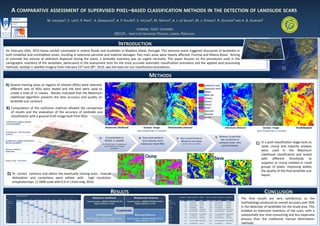
- 1. A COMPARATIVE ASSESSMENT OF SUPERVISED PIXEL–BASED CLASSIFICATION METHODS IN THE DETECTION OF LANDSLIDE SCARS M. LOUSADA1, C. LIRA1, P. PINA1, A. GONÇALVES2, A. P. FALCÃO2, S. HELENO2, M. MATIAS2, A. J. DE SOUSA1, M. J. PEREIRA1, R. OLIVEIRA3 AND A. B. ALMEIDA3 1CERENA, 2ICIST, 3CEHiDRO IST/UTL - INSTITUTO SUPERIOR TÉCNICO, LISBOA, PORTUGAL INTRODUCTION On February 20th, 2010 heavy rainfall culminated in violent floods and mudslides in Madeira Island, Portugal. This extreme event triggered thousands of landslides in both inhabited and uninhabited zones, resulting in extensive personal and material damages. Two main areas were heavily affected: Funchal and Ribeira Brava. Aiming to estimate the volume of sediment displaced during the event, a landslide inventory was an urgent necessity. This paper focuses on the procedures used in the cartographic inventory of the landslides, particularly in the assessment tests for the most accurate automatic classification procedure and the applied post-processing methods. GeoEye-1 satellite imagery from February 23rd and 28th, 2010, was the basis for our classification procedures. METHODS A) Several training areas or regions of interest (ROIs) were selected, LANDSLIDE SCAR different sets of ROIs were tested and the best were used to LANDSLIDE TRACK GRASS create a total of 11 classes . Results indicated that the Maximum BARE SOIL Likelihood algorithm presents the best accuracy and quality on CLOUDS landslide scar contours. GRAVEL FOREST B) Computation of the confusion matrices allowed the comparison ROOFS INDUSTRY of results and the evaluation of the accuracy of landslide scar SHADOW classification with a ground truth image built from ROIs. ROADS Landslide Scars, polygons manually corrected/validated Maximum Likelihood GeoEye image Mahalanobis Distance Minimum Distance GeoEye image Parallelepiped Ortophotomaps with 0.4m spatial (pan-sharpening 0.5 m/pixel) (pan-sharpening 0.5 m/pixel) resolution A) CLASSIFICATIONS IN B) CONFUSION MATRICES D) MANUAL DELINEATION C) POST-CLASSIFICATION OF GEOEYE -1 IMAGERY AND VALIDATION OF Landslide Scars, polygons obtained from WITH GROUND TRUTH MAXIMUM LIKELIHOOD Max-Like classification (R-G-B-NIR band, 2 m/pixel and IMAGE BUILT FROM ROIS SIEVING AND CLUMPING LANDSLIDE SCARS WITH C) In a post-classification stage tools as panchromatic 0.5 m/pixel resolution) ORTOPHOTOMAPS sieve, clump and majority analysis Maximum Likelihood classification were used in the Maximum Likelihood classification and tested Clump Sieve with different thresholds to GeoEye image ( 0.5m/pixel) suppress or clump isolated or small groups of pixels, improving widely the quality of the final landslide scar D) To correct contours and obtain the eventually missing scars , manual layout. delineation and corrections were edited, with high resolution ortophotomaps (1:5000 scale with 0.4 m ) from may, 2010. Ground Truth (Percent) RESULTS CONCLUSION Class Lnds. scar Lnds. track Grass Bare soil Clouds Gravel Forest Roofs Industry Shadow Roads Total Maximum Likelihood Mahalanobis Distance Commission Omission Commission Omission User Acc. Prod. Acc. Prod. Accuracy User Accuracy The final results are very satisfactory, as the Class (Percent) (Percent) (Pixels) (Pixels) (Percent) (Percent) (Pixels) (Pixels) Overall Accuracy = (969054/1033569) 93.76% Overall Accuracy = (836836/1033569) 80.97% Landslide scar Landslide track 92,58 3,26 3,81 95,91 0 0 0,91 0,01 0 0 0 0 0,06 0 1,03 0,67 0,07 0 0 0 0,12 0 0,6 0,71 Kappa Coefficient = 0.915 Kappa Coefficient = 0.749 Landslide scar Landslide track 11,17 3,31 7,42 693/6206 4,09 244/7366 442/5955 304/7426 92,58 95,91 88,83 5513/5955 96,69 7122/7426 5513/6206 7122/7366 methodology produced an overall accuracy over 90% Grass 0,52 0,05 99,82 0 0 0,01 0,35 0 0 0 0 0,89 Bare soil 2,4 0,09 0 99,08 0 0 0,02 0 0 0 0 0,84 Grass Bare soil 13,59 2,36 0,18 1246/9168 0,92 204/8634 14/7936 78/8508 99,82 99,08 86,41 7922/7936 97,64 8430/8508 7922/9168 8430/8634 in the detection of landslides for the study area. This Clouds 0,13 0,07 0 0 99,01 0,07 0,04 0 0,19 0 0,32 26,32 CLASSIFICATION Clouds 0,1 0,99 283/272044 2709/274470 99,01 99,9 271761/274470 271761/272044 Gravel Forest 0,12 0,3 0,03 0 0,18 0 0 0 0 0 58,01 0,47 0,15 93,39 2,22 0,01 15,77 0,1 0,48 2,29 7,22 0,11 3,81 31,8 Gravel 18,76 41,99 7390/39395 23164/55169 58,01 81,24 32005/55169 32005/39395 enabled an extensive inventory of the scars, with a Roofs Industry 0,69 0 0,04 0 0 0 0 0 0,99 0 0,01 3,35 0 0 93,23 1,4 0,31 80,41 0 0 0,08 1,14 0,66 2,82 Parallelepiped Minimum Distance Forest Roofs 2,08 2,15 6,61 6841/328725 6,77 146/6782 22797/344681 482/7118 93,39 93,23 97,92 321884/344681 321884/328725 97,85 6636/7118 6636/6782 substantially less time-consuming and less expensive Industry 16,25 19,59 4745/29192 5955/30402 80,41 83,75 24447/30402 24447/29192 Shadow Roads 0 0 0 0 0 0 0 0 0 0 2,27 35,8 5,99 0 0 1,43 0,03 3,13 97,22 0 0 91,01 28,87 2,68 Overall Accuracy = (336155/1033569) 32.52% Kappa Coefficient = 0.243 Overall Accuracy = (831048/1033569) 80.41% Kappa Coefficient = 0.742 Shadow 7,34 2,78 21917/298406 7894/284383 97,22 92,66 276489/284383 276489/298406 process than the traditional manual delimitation Total 100 100 100 100 100 100 100 100 100 100 100 100 Roads 75,25 8,99 20806/27651 676/7521 91,01 24,75 6845/7521 6845/27651 methods.