Report
Share
Download to read offline
Recommended
Recommended
More Related Content
Featured
Featured (20)
Product Design Trends in 2024 | Teenage Engineerings
Product Design Trends in 2024 | Teenage Engineerings
How Race, Age and Gender Shape Attitudes Towards Mental Health
How Race, Age and Gender Shape Attitudes Towards Mental Health
AI Trends in Creative Operations 2024 by Artwork Flow.pdf
AI Trends in Creative Operations 2024 by Artwork Flow.pdf
Content Methodology: A Best Practices Report (Webinar)
Content Methodology: A Best Practices Report (Webinar)
How to Prepare For a Successful Job Search for 2024
How to Prepare For a Successful Job Search for 2024
Social Media Marketing Trends 2024 // The Global Indie Insights
Social Media Marketing Trends 2024 // The Global Indie Insights
Trends In Paid Search: Navigating The Digital Landscape In 2024
Trends In Paid Search: Navigating The Digital Landscape In 2024
5 Public speaking tips from TED - Visualized summary
5 Public speaking tips from TED - Visualized summary
Google's Just Not That Into You: Understanding Core Updates & Search Intent
Google's Just Not That Into You: Understanding Core Updates & Search Intent
The six step guide to practical project management
The six step guide to practical project management
Beginners Guide to TikTok for Search - Rachel Pearson - We are Tilt __ Bright...
Beginners Guide to TikTok for Search - Rachel Pearson - We are Tilt __ Bright...
Antigo_Flood
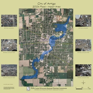
- 1. City of Antigo 2004 Flood - Impact Area This map is neither a legally recorded map nor a survey and is not intended to be used as one. This drawing is a compilation of records, information and data used for reference purposes only. NCWRPC is not responsible for any inaccuracies herein contained. © 0 0.50.25 Miles Source: NCWRPC, Langlade Co., 2005 Airphoto 600 Block Looking South 500 Block Looking South East Downtown Looking North West 600 Block Looking East 300 Block Looking North East 100 Block Looking South East Prepared By: NCWRPC 210 McClellan St., Suite 210, Wausau, WI 54403 715-849-5510 - staff@ncwrpc.org - www.ncwrpc.org North Central Wisconsin Regional Planning Commission