
Recommended
More Related Content
What's hot
What's hot (20)
More from Matt Guptail, GISP
Adam Co_Dam_Faliure
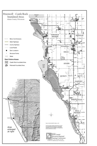
- 1. & & "ÿC "ÿZ "ÿB "ÿH "ÿZ "ÿK "ÿC "ÿZ "ÿJ "ÿF "ÿZ "ÿE "ÿA "ÿB "ÿN "ÿQ "·21 "·13 "· "·13 "·82 "ÿJ "ÿJ "ÿM "ÿK "ÿK Petenwell Dam Castle Rock Dam Petenwell Lake Castle Rock Lake WisconsinRiver W isconsinRiver ADAMS QUINCY EASTON MONROE PRESTON SPRINGVILLE STRONGS PRAIRIE DELL PRAIRIE Adams Friendship Wisconsin Dells Petenwell - Castle Rock Inundated Areas Adams County, Wisconsin This map is neither a legally recorded map nor a survey and is not intended to be used as one. This drawing is a compilation of records, information and data used for reference purposes only. NCWRPC is not responsible for any inaccuracies herein contained. Source: WI DNR, NCWRPC, Adams Co. EM 210 McClellan St., Suite 210, Wausau, WI 54403 715-849-5510 - staff@ncwrpc.org - www.ncwrpc.org North Central Wisconsin Regional Planning Commission Prepared By: NCWRPC © & & "·73 "·13 "·21 "·21 "·23 "·13 "·82 "·13 "·82 Petenwell Dam Castle Rock Dam WisconsinRiver Petenwell Lake Castle Rock Lake WisconsinRiver Area enlarged at right ROME ADAMS LEOLA QUINCY BIG FLATS EASTON MONROE LINCOLN JACKSON PRESTON COLBURN SPRINGVILLE RICHFIELD STRONGS PRAIRIE NEW HAVEN DELL PRAIRIE NEW CHESTER Adams Friendship Wisconsin Dells Dam Failure Areas Minor Civil Divisions State Highways County Highways Local Roads Dam Locations Structure Points Water Castle Rock Inundated Area Petenwell Inundated Area & "