Kevin Ma - Image Comparison Quad
•Download as PPTX, PDF•
0 likes•56 views
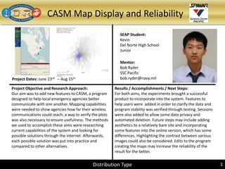
Kevin, a junior at Del Norte High School, worked with mentor Bob Ryder from SSC Pacific to add new features to CASM, a program used by local emergency agencies to coordinate communications. They researched current capabilities and potential solutions to add mapping features showing wireless reach and verify the accuracy of plots. Testing different options, they successfully incorporated features allowing users to view data and check reliability through testing. Future work may include improving the online version and highlighting contrast between images.
Report
Share
Report
Share
Recommended
Succession “Losers”: What Happens to Executives Passed Over for the CEO Job?
By David F. Larcker, Stephen A. Miles, and Brian Tayan
Stanford Closer Look Series
Overview:
Shareholders pay considerable attention to the choice of executive selected as the new CEO whenever a change in leadership takes place. However, without an inside look at the leading candidates to assume the CEO role, it is difficult for shareholders to tell whether the board has made the correct choice. In this Closer Look, we examine CEO succession events among the largest 100 companies over a ten-year period to determine what happens to the executives who were not selected (i.e., the “succession losers”) and how they perform relative to those who were selected (the “succession winners”).
We ask:
• Are the executives selected for the CEO role really better than those passed over?
• What are the implications for understanding the labor market for executive talent?
• Are differences in performance due to operating conditions or quality of available talent?
• Are boards better at identifying CEO talent than other research generally suggests?
Succession “Losers”: What Happens to Executives Passed Over for the CEO Job? 
Succession “Losers”: What Happens to Executives Passed Over for the CEO Job? Stanford GSB Corporate Governance Research Initiative
Human/Social Sciences/Cultural & Behavioral Dynamics and Advanced Analytics
Human/Social Sciences/Cultural & Behavioral Dynamics and Advanced AnalyticsNC Military Business Center
Recommended
Succession “Losers”: What Happens to Executives Passed Over for the CEO Job?
By David F. Larcker, Stephen A. Miles, and Brian Tayan
Stanford Closer Look Series
Overview:
Shareholders pay considerable attention to the choice of executive selected as the new CEO whenever a change in leadership takes place. However, without an inside look at the leading candidates to assume the CEO role, it is difficult for shareholders to tell whether the board has made the correct choice. In this Closer Look, we examine CEO succession events among the largest 100 companies over a ten-year period to determine what happens to the executives who were not selected (i.e., the “succession losers”) and how they perform relative to those who were selected (the “succession winners”).
We ask:
• Are the executives selected for the CEO role really better than those passed over?
• What are the implications for understanding the labor market for executive talent?
• Are differences in performance due to operating conditions or quality of available talent?
• Are boards better at identifying CEO talent than other research generally suggests?
Succession “Losers”: What Happens to Executives Passed Over for the CEO Job?
Succession “Losers”: What Happens to Executives Passed Over for the CEO Job? Stanford GSB Corporate Governance Research Initiative
Human/Social Sciences/Cultural & Behavioral Dynamics and Advanced Analytics
Human/Social Sciences/Cultural & Behavioral Dynamics and Advanced AnalyticsNC Military Business Center
More Related Content
Similar to Kevin Ma - Image Comparison Quad
Similar to Kevin Ma - Image Comparison Quad (20)
Andrea Mocci: Beautiful Design, Beautiful Coding at I T.A.K.E. Unconference 2015
Andrea Mocci: Beautiful Design, Beautiful Coding at I T.A.K.E. Unconference 2015
A simplified predictive framework for cost evaluation to fault assessment usi...
A simplified predictive framework for cost evaluation to fault assessment usi...
A Survey of Agent Based Pre-Processing and Knowledge Retrieval
A Survey of Agent Based Pre-Processing and Knowledge Retrieval
COMPARATIVE STUDY OF SOFTWARE ESTIMATION TECHNIQUES
COMPARATIVE STUDY OF SOFTWARE ESTIMATION TECHNIQUES
TOWARDS PREDICTING SOFTWARE DEFECTS WITH CLUSTERING TECHNIQUES
TOWARDS PREDICTING SOFTWARE DEFECTS WITH CLUSTERING TECHNIQUES
A systematic mapping study of performance analysis and modelling of cloud sys...
A systematic mapping study of performance analysis and modelling of cloud sys...
Running head SOFTWARE DELIVERY PRACTICES2SOFTWARE DELIVERY .docx
Running head SOFTWARE DELIVERY PRACTICES2SOFTWARE DELIVERY .docx
Reliability Improvement with PSP of Web-Based Software Applications
Reliability Improvement with PSP of Web-Based Software Applications
Kevin Ma - Image Comparison Quad
- 1. CASM Map Display and Reliability Project Dates: June 23rd – Aug 15th SEAP Student: Kevin Del Norte High School Junior Mentor: Bob Ryder SSC Pacific bob.ryder@navy.mil Project Objective and Research Approach: Our aim was to add new features to CASM, a program designed to help local emergency agencies better communicate with one another. Mapping capabilities were needed to show agencies how far their wireless communications could reach; a way to verify the plots was also necessary to ensure usefulness. The methods we used to accomplish these aims were researching current capabilities of the system and looking for possible solutions through the internet. Afterwards, each possible solution was put into practice and compared to other alternatives. Results / Accomplishments / Next Steps: For both aims, the experiments brought a successful product to incorporate into the system. Features to help users were added in order to clarify the data and program stability was verified through testing. Sessions were also added to allow some data privacy and automated deletion. Future steps may include adding aesthetics to a relatively bare site and incorporating some features into the online version, which has some differences. Highlighting the contrast between various images could also be considered. Edits to the program creating the maps may increase the reliability of the result for the better. Distribution Type 1Distribution Type 1