More Related Content
Similar to Kevin Ma - CASM Interface Technical Poster
Similar to Kevin Ma - CASM Interface Technical Poster (20)
Kevin Ma - CASM Interface Technical Poster
- 1. Coverage Plots
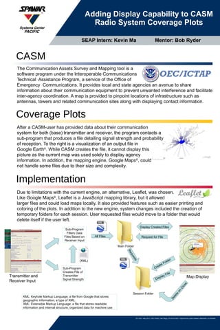
Adding Display Capability to CASM
Radio System Coverage Plots
SD 1002 • May 2012 • SSC Pacific, San Diego, CA 92152-5001 • Approved for public release; distribution is unlimited.
After a CASM-user has provided data about their communication
system for both (base) transmitter and receiver, the program contacts a
sub-program that produces a file detailing signal strength and probability
of reception. To the right is a visualization of an output file in
Google Earth©
. While CASM creates the file, it cannot display this
picture as the current map was used solely to display agency
information. In addition, the mapping engine, Google Maps©
, could
not handle some files due to their size and complexity.
The Communication Assets Survey and Mapping tool is a
software program under the Interoperable Communications
Technical Assistance Program, a service of the Office of
Emergency Communications. It provides local and state agencies an avenue to share
information about their communication equipment to prevent unwanted interference and facilitate
inter-agency coordination. A map is provided to pinpoint locations of infrastructure such as
antennas, towers and related communication sites along with displaying contact information.
CASM
Implementation
Due to limitations with the current engine, an alternative, Leaflet, was chosen.
Like Google Maps©
, Leaflet is a JavaScript mapping library, but it allowed
larger files and could load maps locally. It also provided features such as easier printing and
coloring of the plots. In addition to the new engine, system changes included the creation of
temporary folders for each session. User requested files would move to a folder that would
delete itself if the user left.
Transmitter and
Receiver Input
Map Display
Sub-Program
Filters Data
Files Based on
Receiver Input
Main Folder
Request for File
Sub-Program
Creates File of
Transmitter
Signal Strength
Session Folder
Create Folder
Display Created Files
Display File
Requests
All Files
Delete
on
Close
KML: Keyhole Markup Language; a file from Google that stores
geographic information; a type of XML.
XML: Extensible Markup Language; a file that stores readable
information and internal structure; organized data for machine use
(XML)
SEAP Intern: Kevin Ma Mentor: Bob Ryder