2. 198 L. Wandera et al.: An Artificial Neural Network approach
1 Introduction
Satellite-based mapping and monitoring of daily regional
evapotranspiration (ET hereafter; or latent heat flux, λE) is
considered to be a key scientific concern for multitudes of
applications including drought monitoring, water rights man-
agement, ecosystem water-use efficiency assessment, dis-
tributed hydrological modelling, climate change studies, and
numerical weather prediction (Anderson et al., 2015; Senay
et al., 2015; Sepulcre-Canto et al., 2014). ET variability dur-
ing the course of a day is influenced by changes in the ra-
diative energy being received at the surface (Brutsaert and
Sugita, 1992; Crago, 1996; Parlange and Katul, 1992), due
to soil moisture variability, particularly in the water deficit
landscapes, and also due to the stomatal regulation by vege-
tation.
One of the fundamental challenges in regional ET mod-
elling using polar orbiting satellites involves the upscaling of
instantaneous ET retrieved at any specific time-of-day (ETi
hereafter) to daily ET (ETd hereafter). For example, ETi re-
trieved from LANDSAT, ASTER and MODIS sensors typi-
cally represent ETi at a single snapshot of 10:00, 10:30 and
13:30 LT, which needs to be upscaled to daily timescale for
making this information usable to hydrologists and water
managers (Cammalleri et al., 2014; Colaizzi et al., 2006; Ryu
et al., 2012; Tang et al., 2013).
In order to accommodate the temporal scaling chal-
lenges encountered by remote-sensing-based ET models,
techniques have been proposed and applied by various re-
searchers to upscale ETi to ETd. These include: (1) the con-
stant evaporative fraction (EF) approach which assumes a
constant ratio between λE and net available energy (φ =
Rn −G, Rn is the net radiation and G is the ground heat flux)
during daytime [EF = λE/(Rn − G)] (Gentine et al., 2007;
Shuttleworth et al., 1989), (2) constant reference evapora-
tive fractions (EFr) method where the ratio of ETi between a
reference crop (typically grass measuring a height of 0.12 m
in an environment that is not water-limited) and an actual
surface is assumed to be constant during daytime, allowing
ETd to be estimated from the daily EFr (Allen et al., 1998;
Tang et al., 2013), (3) the constant global shortwave radia-
tion method (RS) where RS is the reference variable at the
land surface and it is assumed that the ratio of daily to in-
stantaneous shortwave radiation (RSd and RSi) values (i.e.
RSd / RSi) determines ETd to ETi ratio (Jackson et al., 1983;
Cammalleri et al., 2014), and (4) the constant extra-terrestrial
radiation method where the exo-atmospheric shortwave ra-
diation (RSTOA) is the reference variable and the ratio of
instantaneous to daily RSTOA (RSiTOA and RSdTOA) is as-
sumed to determine the ratio of ETd to ETi (Ryu et al., 2012;
Van Niel et al., 2012). These methods have been reviewed
and compared in different studies with the purpose of identi-
fying the most robust ETi to ETd upscaling approach based
on different datasets, time integrals, and varying sky condi-
tions (Cammalleri et al., 2014; Ryu et al., 2012; Tang et al,
2013, 2015; Van Niel et al., 2012; Xu et al., 2015).
Based on the previous studies, we find that the RSTOA ap-
proach performed consistently well at lower temporal resolu-
tion, namely 8-day to monthly scales (Ryu et al., 2012; Van
Niel et al., 2012), as well as under clear-sky conditions (Cam-
malleri et al., 2014), whereas the RS approach was identified
as the most preferred method for ETi to ETd conversion at a
higher temporal scale, i.e. daily timescale in addition to un-
der variable sky conditions (Cammalleri et al., 2014; Chávez
et el., 2008; Colaizzi, et al., 2006; Xu et al., 2015). Although
the EFr-based method produced comparable ETd estimates
to the RS-based method, however the dependence of EFr es-
timates on certain variables (e.g. daily net available energy,
φ, and wind speed) and the difficulty to characterise them
at the daily scale from single acquisition of polar orbiting
satellites (Tang et al., 2015) makes it a relatively less attrac-
tive method. Furthermore, the EF-based method appeared to
consistently underestimate ETd in all these studies.
The motivation for the current work is built on the conclu-
sions of Colaizzi et al. (2006), Chávez et al. (2008), Cam-
malleri et al. (2014), and Xu et al. (2015) that the ratio of
the instantaneous to daily RS incident on land surface is the
most robust reference variable explaining the ratio between
ETd and ETi among all the tested methods. This work aims
to contribute to ETi upscaling by first developing a method
for estimating RSd from any specific time-of-day RS infor-
mation (i.e. RSi) and, further, using RSd / RSi ratio as a fac-
tor for converting ETi to ETd. We develop an artificial neu-
ral network (ANN) machine learning algorithm (McCulloch
and Pitts, 1943) for estimating RSd. Although net radiation
(Rn) is more closely associated with ET, RS constitutes 80–
85 % of Rn (Mallick et al., 2015). Also from the remote-
sensing perspective, RSi is relatively easily retrievable irre-
spective of the sky conditions (Wang et al., 2015; Lopez and
Batlles, 2014), and its relationship to RSd is primarily gov-
erned by cloudiness (cloud fraction, cloud optical depth) and
astronomical variables (e.g. solar zenith angle, day length,
RSTOA). Given the information of cloudiness is also obtain-
able from remote sensing, we consider RS to be a robust vari-
able to explore ETi upscaling.
Even though this study is intended for remote sensing ap-
plication, we tested the method using meteorological and
surface energy balance flux measurements from eddy co-
variance (EC) system at the FLUXNET (Baldocchi et al.,
2001) sites mainly for the purpose of temporal consis-
tency. However, we evaluate the performance in consider-
ation with overpass time of polar orbiting satellites com-
monly used in operational ET mapping, namely MODIS and
LANDSAT. By choosing to use data distributed over differ-
ent ecosystems and climate zones, we are faced with two
problems: (1) changing cloud conditions across ecosystems
and (2) varying energy balance closure (EBC) requirements
for the fluxes in different ecosystems (Foken et al., 2006;
Franssen et al., 2010; Mauder and Foken, 2006; Wilson et
Hydrol. Earth Syst. Sci., 21, 197–215, 2017 www.hydrol-earth-syst-sci.net/21/197/2017/
3. L. Wandera et al.: An Artificial Neural Network approach 199
al., 2002). Currently, information on cloudiness is obtain-
able from geostationary meteorological satellites, at hourly
to 3 h time steps, e.g. from the Clouds and Earth’s Radiant
Energy System (CERES), the International Satellite Cloud
Climatology Project-Flux Data (ISCCP-FD), and Global En-
ergy and Water cycle Experiment Surface Radiation Budget
(GEWEX-SRB). The CERES algorithm uses cloud informa-
tion from MODIS onboard both Terra and Aqua platforms
and combines it with information from geostationary satel-
lites to accurately capture the diurnal cycles of clouds. In this
study, cloudiness is not included in the list of variables used
to estimate RSd due to inconsistency in spatial resolution of
data to match with the other predictive variables used. Includ-
ing cloudiness holds great potential for improving the ANN
RSd predictions due to their direct relationship (Mallick et
al., 2015). However, we assess the performance of the ANN
under cloudy sky conditions based on simple cloudiness in-
dex computations as adopted from previous works (Baig-
orria et al., 2004). The EBC problems have been reported
to vary across landscapes due to management practices, cli-
mate, seasons, and plant functional type characteristics (Fo-
ken et al., 2006). In this study, in order to test the robust-
ness of the proposed method, we initially disregard the site-
specific EBC problems and assumed that the systematic bias
of fluxes fall within the same range across entire FLUXNET
database used.
The objectives of the present study are: (1) using a ANN
with Multilayer Perceptron (MLP) architecture to predict
RSd based on RSi satellite observations, (2) applying the
RSd / RSi ratio as a scaling factor to upscale ETi to ETd under
all sky conditions, and (3) comparing the performance of the
proposed RS-based ETi upscaling method with RSTOA and
EF-based ETi upscaling methods across a range of temporal
scales, biomes, and variable sky conditions.
2 Methodology
2.1 Rationale
The presented method of ET upscaling from any specific
time-of-day to daily average evaporative fluxes is based on
the assumption of self-preservation of incoming solar en-
ergy (i.e. shortwave radiation) as proposed by Jackson et
al. (1983).
ETd ≈ ETi
RSd
RSi
, (1)
where ETd is the daily average evapotranspiration in W m−2,
ETi is the instantaneous evapotranspiration at any instance
during daytime in W m−2, RSi and RSd are the values of
shortwave radiation recorded at any instance and the daily
average having units W m−2. Daily total ETd and RSd is ex-
pressed in MJ m−2 d−1 by using standard conversion from
watts to mega joules. Following Jackson et al. (1983) and
Inputs
RSi
RSiTOA
RSdTOA
Z
LD
Output
RSd_obs
ANN
RSd_pred
RSd estimation approach
ETd_pred
ETd upscaling approach
Validation against ETd_obs
Figure 1. A conceptual diagram of the methodology. On the left
side is a representation of predicting daily incoming shortwave ra-
diation (RSd_pred). The ANN is trained to learn the system response
to a combination of explanatory variables (i.e. instantaneous in-
coming shortwave radiation (RSi), instantaneous exo-atmospheric
shortwave radiation (RSiTOA), daily exo-atmospheric shortwave
radiation (RSdTOA), solar zenith angle (θZ), and day length (LD))
by being fed with a sample data of observed daily incoming short-
wave radiation (RSd_obs) which is the dependant variable. On the
right side are methods of upscaling instantaneous (ETi) to daily ET
(ETd) using our RS-based method (a) and the other two approaches
(b, c) are the RSTOA- and EF-based methods respectively, which
are used for comparison of Rs-based method.
Cammalleri et al. (2014), we hypothesised that the mean di-
urnal variation of ET for any particular day scales with the
mean diurnal variation of RS. The justifications are: (a) RS is
the principal driver that controls sub-daily ET variability un-
less there is substantial diurnal asymmetry in cloudiness or
abrupt change in sub-daily soil moisture between morning
and afternoon. (b) Under persistent cloudy conditions, ET
scales with RS. Under clear-sky conditions ET also scales
with RS and both are in phase if sufficient soil moisture is
available at the surface. (c) Phase difference between RS and
ET is commonly found under soil moisture deficit conditions
in clear-sky days. However, the magnitude of clear-sky ETi
in water deficit conditions is also very low, which will lead
to substantially low ETi / RSi ratio, and would be unlikely
to introduce any uncertainty in ETi to ETd upscaling in the
framework of Eq. (1).
For any remote sensing studies using polar orbiting satel-
lites, although the retrieval of ETi and RSi has been stan-
dardised (Tang et al., 2015; Huang et al., 2012; Polo et al.,
2008; Laine et al., 1999), but estimating RSd and ETd from
RSi and ETi are still challenging. Presently, upscaling RSi
to RSd is primarily based on the clear-sky assumption, i.e.
for the entire daytime integration period, the sky remains
cloud-free (Bisht et al., 2005; Jackson et al., 1983). How-
ever, the clear-sky assumption is not always appropriate for
upscaling remote-sensing-based RSi and hence ETi because
the sky conditions during a specific time-of-day may be clear
www.hydrol-earth-syst-sci.net/21/197/2017/ Hydrol. Earth Syst. Sci., 21, 197–215, 2017
4. 200 L. Wandera et al.: An Artificial Neural Network approach
Output layerHidden layer
Input Output
Figure 2. Schematic representation of a simple artificial network model. The artificial neuron has five input variables, for the intended
output. These inputs are then assigned weights (w) and bias (b), and the sum of all these products ( ) is fed to an activation function (f ).
The activation function alters the signal accordingly and passes the signal to the next neuron(s) until the output of the model is reached
(Mathworks, 2015).
whereas it might be cloudy for the other part of the day. Un-
der such conditions, the clear-sky assumption of ETi upscal-
ing will lead to substantial overestimation of ETd. Hence re-
liable estimates of all-sky (i.e. both clear and cloudy) RSd
would greatly improve the ETd estimates in the framework
of Eq. (1). Given the unavailability of a definite method to
directly estimate all-sky RSd from RSi information, here we
proposed a simple method to upscale RSi to RSd using ANN.
This method uses the observations of both RSd and RSi from
all the available FLUXNET sites in conjunction with some
ancillary variables to build the ANN as described in Sect. 2.2.
A schematic diagram of the ANN method is given in Fig. 1.
The analysis is based on a 24 h period, meaning night-time
ET contribution is implicitly considered. However, studies
have already shown that the night-time ET in semi-arid and
sub-humid regions contributes only 2–5 % of the total season
ET (Malek, 1992; Tolk et al., 2006), and therefore does not
appear to be significant.
The overarching aim of this study is to develop an ap-
proach that would help in the upscaling of ETi (retrieved at
satellite overpass time) to ETd. An additional value of this
study also consists of exploiting RSi information at satellite
local crossing time to predict RSd which is not directly re-
trievable from any polar orbiting satellites, so that the ratio
of RSd / RSi can be further used to upscale ETi to obtain ETd
estimates. Currently we are limited to demonstrating with
MODIS satellite overpass times (Terra and Aqua); however
for the future missions with different local overpass time, the
method would still be applicable.
In any natural ecosystem, RS on a particular day is primar-
ily influenced by the clouds (especially cloud cover fraction
and optical thickness; Mallick et al., 2015; Hildebrandt et
al., 2007), latitude, season, and time of day. Therefore, RSd
on any specific day is expected to be a function of RSi (as
a representative of RS and cloudiness factors), solar zenith
angle (representing latitude, season, time of day), day length
(representing latitude and season), and RSTOA (represent-
ing latitude, season, and time of day). Besides, atmospheric
aerosols also interact with RS and absorb some of the radia-
tion, particularly in the urban areas. Considering the applica-
tions of ETi to ETd modelling in the natural ecosystems, we
include RSi, RSiTOA, RSdTOA, solar zenith angle, and day
length for RSd (and subsequently ETd) prediction.
2.2 Development of the Artificial Neural Network
(ANN)
ANN is a non-linear model which works by initially under-
standing the behaviour of a system based on a combination
of a given number of inputs, and subsequently is able to sim-
ulate the system when fed with an independent set of inputs
of the same system. ANN approach has been successfully
used in estimating global solar radiation in many sectors and
more so in the field of renewable energy (Ahmad et al., 2015;
Hasni et al., 2012; Lazzús et al., 2011). Multi-layer percep-
tron (MLP) is one of the ANN architectures commonly used
as opposed to other statistical methods; it makes no prior as-
sumptions concerning the data distribution and has the ability
to reasonably handle non-linear functions and reliably gener-
alise independent data when presented (Gardner and Dorling,
1998; Khatib et al., 2012; Wang, 2003). In the present study,
MLP was chosen as it has been widely used in many similar
studies and cited to be a better alternative compared to the
conventional statistical methods (Ahmad et al., 2015; Chen
et al., 2013; Dahmani et al., 2016; Mubiru and Banda, 2008).
The MLP is composed of 5 neurons in the input layer, 1 out-
put layer and 10 hidden layers (Fig. 2). The input layer neu-
rons are made up of instantaneous incoming shortwave radi-
ation (RSi), instantaneous exo-atmospheric shortwave radi-
ation (RSiTOA), daily exo-atmospheric shortwave radiation
(RSdTOA), solar zenith angle (θZ), and day length (LD) as
the predictor variables whose values are initially standardised
to range between −1 and 1. The choice of the inputs is inten-
tionally limited to the variables that cannot only be acquired
by measurements from meteorological stations but are also
derived from simple astronomical computations (Ryu et al.,
2012), mainly to help minimise the spatial distribution prob-
lem complexities (as described earlier in the introduction)
that is often linked to ground weather stations. In the MLP
processing, the input layer directs the values of each input
Hydrol. Earth Syst. Sci., 21, 197–215, 2017 www.hydrol-earth-syst-sci.net/21/197/2017/
5. L. Wandera et al.: An Artificial Neural Network approach 201
km
Figure 3. Distribution of 126 sites of the FLUXNET eddy covari-
ance network used in the present study with 85 and 41 sites for
training and validation between the years 1999 and 2006, respec-
tively.
neuron xi (i = 1, 2, 3... n) into each neuron (j) of the hidden
layers. In the hidden layer, xi is multiplied by a weight (wij )
followed by a bias (bj ) assigned for each hidden layer. The
weighted sum (Eq. 2) is fed into a transfer function. In this
work a tangent sigmoid (TANSIG) function is used (Eq. 3) in
the hidden layer while in the output layer a PURELIN func-
tion is applied (Eq. 4) to give a single output value which is
the predicted daily shortwave radiation (RSd_pred). PURELIN
is a linear neural transfer function used in a backpropagation
network. It calculates a layer’s output from its net input. The
function generates outputs between zero and 1 as the neu-
ron’s net input goes from negative to positive infinity. The
training of the ANN is completed by a regression analysis
being performed internally by the algorithm between the tar-
get variable, i.e. the observed and predicted daily shortwave
radiation (RSd_pred and RSd_pred).
Xj =
n
j=1
wij yj bj (2)
yj =
2
1 + exp −2Xj − 1
(3)
yj = Xj (PURELIN) (4)
The Bayesian regularisation algorithm was chosen for the op-
timisation process because it is able to handle noisy datasets
by continuously applying adaptive weight minimisation, and
can reduce or eliminate the need for lengthy cross-validation
that often leads to overtraining and overfitting of models
(Burden and Winkler, 2009).
2.3 Datasets
Daily and half-hourly data on RS (W m−2), RSTOA, net ra-
diation (Rn, W m−2), latent heat flux (λE, W m−2), sensi-
ble heat flux (H, W m−2), and ground heat flux (G, W m−2)
measured by the FLUXNET (Baldocchi et al., 2001) eddy
covariance network were used. A total of 126 sites from the
years 1999 to 2006, distributed between latitude 0–90◦ north
and south of the Equator, were used for the present analysis.
The data sites covered a broad spectrum of vegetation func-
tional types and climatic conditions and a list of the sites are
given in Table S1 in the Supplement.
Among 126 sites, 85 sites were used for training and the
remaining 41 sites were used for validation. Partition of the
data into training and validation was randomly selected re-
gardless of the year. These translated into 194 and 86 yearly
data for the respective samples. A global distribution of the
data sites is shown in Fig. 3. From the training dataset, three
samples were internally generated by the algorithm, i.e. train-
ing datasets, validation datasets, and a testing dataset in a per-
centage ratio of 80 : 15 : 5 respectively. The ANN algorithm
is designed to validate its performance for any given training
which in most cases should be sufficient for validating the
network. However, to ensure the network is robust, we fur-
ther test the generated network with an independent dataset.
Considering the equatorial crossing time of different polar
orbiting sensors like LANDSAT, ASTER, and MODIS Terra-
Aqua, unique networks were generated for different time of
day from morning to afternoon, and thus we had a total of
eight networks to represent potential satellite overpass times
between 10:30 and 14:00 LT using 30 min intervals as the
closest reference time for each hour. The generated networks
were then applied to an independent validation dataset.
2.4 Intercomparison of ETi upscaling methods
An intercomparison of three different ETi upscaling methods
is performed with the homogeneous datasets to assess their
relative performance across a range of temporal scales and
variable sky conditions. These are:
a. The RS-based upscaling method, where ANN-predicted
RSd is used in conjunction with observed RSi to predict
ETd using Eq. (1).
b. The exo-atmospheric irradiance method (Ryu et al.,
2012) where the reference variable is RSTOA.
RSdTOA = Ssc 1 + 0.033cos
2πtd
365
cosθZ, (5)
SFRTOA =
RSdTOA
RSiTOA
, (6)
ETd = ETiSFRTOA, (7)
where Ssc is the solar constant (1360 W m−2), td is the
day of the year (DoY), and θZ is the solar zenith angle.
www.hydrol-earth-syst-sci.net/21/197/2017/ Hydrol. Earth Syst. Sci., 21, 197–215, 2017
6. 202 L. Wandera et al.: An Artificial Neural Network approach
b. The EF-based method (Cammalleri et al., 2014), where
the reference variable is the net available energy (φ; i.e.
Rn-G).
SFEF =
ETi
(Rn − G)i
, (8)
ETd = 1.1(Rn − G)dSFEF, (9)
where SFEF is the EF-based scaling factor, (Rn-G)i and (Rn-
G)d are the instantaneous and daily net available energy, re-
spectively.
We tested the performance of the three upscaling algo-
rithms for all possible sky conditions assumed to be rep-
resented by daily atmospheric transmissivity (τ; Eq. 10),
namely (i) 0.25 ≥ τ ≥ 0 (τ1, hereafter), (ii) 0.5 ≥ τ ≥ 0.25
(τ2, hereafter) (iii) 0.75 ≥ τ ≥ 0.5 (τ3, hereafter), and (iv) 1 ≥
τ ≥ 0.75 (τ4, hereafter). We use daily τ because it indicates
the overall sky condition throughout a day.
τ =
RSd
RSdTOA
(10)
RSd and RSdTOA are daily shortwave radiation and
the exo-atmospheric shortwave radiation, respectively,
in MJ m−2 d−1 (converted from W m−2).
2.5 Statistical error analysis
The relative performance of the ANN and three upscaling
methods is evaluated using some statistical indices, namely:
coefficient of determination (R2), root mean square error
(RMSE), mean absolute percentage error (MAPE), index of
agreement (IA), and bias. ETd estimates using the respective
upscaling coefficients were compared with measured ETd.
R2
= 1 −
n
i=1(pi − oi)2
n
i=1(oi)2
, (11)
RMSE =
n
i=1(oi − pi)2
n
, (12)
MAPE =
1
n
n
i=1
|oi − pi|
n
× 100, (13)
IA =
n
i (pi − oi)2
n
i=1(|pi − oi| + |oi − pi|)2
, (14)
Bias =
n
i=1 (pi − oi)
n
, (15)
where n is the number of data points; oi and pi are daily
observed and estimated RSd or ETd, respectively. O was the
mean value of observed RSd or ETd.
2.6 Sensitivity of ANN training and validation
Given the majority of the FLUXNET sites represent for-
est biomes and the distribution of EC sites over non-forest
biomes are proportionately lower compared to the forests, we
performed a sensitivity analysis of the ANN-based approach
by assessing the error statistics (R2 and RMSE) of predicted
ETd for different scenarios of ANN training. Three case stud-
ies were generated: (a) Case1, where ANN was trained by
including data randomly from the forests and ETd valida-
tion was done in non-forest biomes (i.e. grassland, crops, and
shrublands); (b) Case2, where ANN was trained by includ-
ing data randomly from the non-forest biomes and predicted
ETd was evaluated in forest biome; (c) Case3, where ANN
was trained by using data randomly from equal proportions
of forest and non-forest biomes, and ETd validation was also
done in forest and non-forest biomes. Each individual case
was replicated 10 times and an ensemble of mean statistics
of predicted ETd is reported in Sect. 3.5.
3 Results and discussions
3.1 Testing the performance of predicted RSd
Given that the performance of ETd upscaling depends on
the soundness of RSd estimation, we first evaluate the effi-
cacy of the ANN method for predicting Rsd. Figure 4 sum-
marises the statistical results of predicted RSd (RSd_pred,
hereafter) including all the site-year average R2, RMSE, IA,
and MAPE values for eight different time-of-day upscaling
time slots. The RMSE of RSd_pred from morning upscal-
ing varied between 1.81 and 1.85 MJ m−2 d−1, with MAPE,
R2, and IA varying across the ranges 20–21 %, 0.76–0.77,
and 0.79–0.80, respectively (Fig. 4). For the afternoon, these
statistics were almost similar and varied across the ranges
1.83–1.96 MJ m−2 d−1, 19–20 %, 0.75–0.77, and 0.80–0.81
(Fig. 4). Given the minimal discrepancy in error statistics
from both morning and afternoon integration and taking into
account the MODIS Terra-Aqua average overpass time, we
have considered 11:00 and 13:30 LT for the detailed follow-
up analysis.
Figure 5a and b evaluates RSd_pred statistics under different
levels of atmospheric transmissivity (τ; 0.25 ≥ τ ≥ 0, 0.5 ≥
τ ≥ 0.25, 0.75 ≥ τ ≥ 0.5, and 1 ≥ τ ≥ 0.75) with an overall
RMSE of 1.81 and 1.83 MJ m−2 d−1 for the morning and
afternoon upscaling respectively. Table 1 and Fig. 5 clearly
show an overestimation tendency of the current method un-
der persistent cloudy sky conditions (τ1), whereas the pre-
dictive capacity of the ANN model is reasonably strong with
increasing atmospheric clearness. The RMSE of RSd_pred for
different τ class from morning upscaling varied between
0.62 and 2.45 MJ m−2 d−1, with MAPE, R2, and IA of 9.2
to 53 %, 0.67 to 0.98, and 0.67 to 0.95, respectively (Ta-
ble 1). For the afternoon upscaling these statistics were 0.89
to 2.4 MJ m−2 d−1 (RMSE), 2.4 to 52 % (MAPE), 0.65 to
0.98 (R2), and 0.67 to 0.95 (IA; Table 1).
The overestimation of RSd_pred at low values of τ is pre-
sumably associated with varying levels of cloudiness during
Hydrol. Earth Syst. Sci., 21, 197–215, 2017 www.hydrol-earth-syst-sci.net/21/197/2017/
7. L. Wandera et al.: An Artificial Neural Network approach 203
Table 1. Statistical analysis of the performance of ANN in predicting RSd under varying sky conditions represented by four different classes
of daily atmospheric transmissivity (τ). Here the statistical metrics of RSd_pred for two different upscaling hours (11:00 and 13:30 LT) are
presented.
Time of day τ R2 RMSE IA MAPE Bias
(LT) (MJ m−2 d−1) (%) (MJ m−2 d−1)
11:00 τ1 0.67 1.84 0.67 53.56 1.12
τ2 0.79 2.45 0.80 16.69 0.59
τ3 0.88 2.30 0.82 9.17 −0.74
τ4 0.98 0.63 0.95 1.69 0.08
13:30 τ1 0.65 1.77 0.67 51.50 1.06
τ2 0.81 2.44 0.81 16.83 0.69
τ3 0.89 2.23 0.83 8.94 −0.85
τ4 0.98 0.89 0.95 2.40 −0.46
Figure 4. Statistical metric of RSd_pred by ANN for different times of day. As the study is intended for remote sensing application, we
demonstrate the potential of the method for future research in the case where the satellite will be used, and as such we pick MODIS overpass
time as an example to highlight the predictive ability of the ANN at the specific overpass times.
the daytime. Since RSd_pred depends on the magnitude of RSi,
LD, θZ, RSiTOA, and RSdTOA, there will be a tendency to over-
estimate RSd_pred on partly cloudy days if RSi at a specific
time of day is not affected by the clouds (LD, θZ, RSiTOA,
and RSdTOA are not influenced by the clouds).
3.2 Evaluation of predicted ETd based on RSd_pred
Figure 6 summarises the statistical results of predicted ETd
(ETd_pred, hereafter) for eight different time-of-day slots.
Upon statistical evaluation, all the cases showed a signif-
icantly linear relationship between ETd_pred and observed
ETd (ETd_obs, hereafter). The RMSE of ETd_pred from morn-
ing upscaling varied from 1.67 to 1.84 MJ m−2 d−1, with
MAPE, R2, and IA varying across the ranges 30–34 %,
0.62–0.68, and 0.77–0.80, respectively (Fig. 6). For the af-
ternoon upscaling, these statistics varied across the ranges
1.5–1.6 MJ m−2 d−1, 29–30 %, 0.67–0.71, and 0.80 (Fig. 6).
These results also indicate that the error statistics were nearly
uniform and the accuracy of ETd_pred varied only slightly
when integration was done from different times of day be-
tween 10:30 and 14:00 LT. These typical error characteris-
tics can greatly benefit the ETd modelling using polar or-
biting data with varying overpass times between 10:30 and
www.hydrol-earth-syst-sci.net/21/197/2017/ Hydrol. Earth Syst. Sci., 21, 197–215, 2017
8. 204 L. Wandera et al.: An Artificial Neural Network approach
(a) (b)
Figure 5. Scatter plots showing RSd_pred vs. RSd_obs for different levels of daily atmospheric transmissivity classes (τ) from (a) 11:00
to (b) 13:30 LT upscaling. Here τ1–τ4 represent daily atmospheric transmissivity of four different classes, 0.25 ≥ τ ≥ 0, 0.50 ≥ τ ≥ 0.25,
0.75 ≥ τ ≥ 0.50, and 1 ≥ τ ≥ 0.75, respectively, with τ1 signifying a high degree of cloudiness (or overcast skies) whereas τ4 indicates clear
skies.
Figure 6. Statistical summary of ETd_pred for different times of day using Eq. (1) based on RSi and RSd_pred. As the study is intended for
remote sensing application, we once again demonstrate the potential of the method for future research in the case where satellite will be used
and as such we pick MODIS Terra-Aqua overpass time.
14:00 LT. This also opens up the possibility of using either
a morning satellite (e.g. MODIS Terra, LANDSAT, ASTER
etc.) or afternoon satellite (i.e. MODIS Aqua) to upscale ETi
to ETd. Following RSd, here also we restricted our analysis
to the two different times of day (11:00 and 13:30 LT) repre-
senting Terra and Aqua overpass times.
Figure 7a and b compares ETd_pred against ETd_obs for
different levels of daily τ. The overall RMSE, MAPE, and
Hydrol. Earth Syst. Sci., 21, 197–215, 2017 www.hydrol-earth-syst-sci.net/21/197/2017/
9. L. Wandera et al.: An Artificial Neural Network approach 205
(a) (b)
Figure 7. ETd_pred obtained through Eq. (1) vs. ETd_obs for different levels of τ from both morning (a) and afternoon (b) upscaling (11:00
and 13:30 LT).
R2 were 1.86 and 1.55 MJ m−2 d−1, 31 and 36 %, and 0.65
and 0.69 for the morning and afternoon upscaling, respec-
tively. As seen in Fig. 7, there is a systematic overestima-
tion of ETd_pred relative to the tower-observed values for low
range of τ (i.e. cloudy sky). It is important to realise that, un-
like ETd_obs, ETd_pred might be an outcome of ETi instances
when the sky was not overcast, i.e. the sky conditions might
be clear at specific time-of-day but can be substantially over-
cast for the remainder of the daytime. As a result, any bias
in the daily shortwave radiation prediction (RSd_pred) will re-
sult in biased ETd_pred according to Eq. (1), and the omis-
sion of non-clear sky conditions at any particular time of
daytime would tend to lead to ETd_pred > ETd_obs for gen-
erally overcast days. However, there could be another op-
posite case that the sky is cloudy at for example 11:00 LT
but clear at other times. This will probably lead to an un-
derestimation of RSd_pred, and consequently underestimation
of ETd_pred. Such cases were also found in τ3 categories in
Fig. 7 where clouds of data points clearly falling significantly
below the 1:1 line, thus showing substantial underestimation
of ETd_pred. Since ETd_obs are the integrations of multiple
ETi measurements, such conditions could be conveniently
captured in the observations which were not possible in the
current framework of ETd_pred. Therefore, when upscaling
was done under clear skies at nominal acquisition time for
generally overcast days, higher errors in ETd_pred can be ex-
pected (Cammalleri et al., 2014) and vice versa. We exam-
ined this cloudy sky overestimation pattern in greater detail
by evaluating the error statistics in ETd_pred for four different
levels of daily τ categories (Fig. 8).
Statistical evaluation of ETd_pred for different classes of
daily τ (estimated as the ratio between daily observed RSd
and RSdTOA) indicates the tendency of higher RMSE and
low R2 in ETd_pred under the persistent cloudy-sky con-
ditions (τ1), while the performance of ETd_pred is reason-
ably good with increasing atmospheric clearness (τ2,τ3,
and τ4) (Fig. 8). The RMSE of ETd_pred for different τ
class from morning upscaling varied between 1.09 and
2.96 MJ m−2 d−1, with MAPE, R2, and IA of 25 to 75 %,
0.38 to 0.79, and 0.71 to 0.82, respectively. For the afternoon
upscaling, these statistics were 0.98 to 2.02 MJ m−2 d−1
(RMSE), 24 to 87 % (MAPE), 0.40 to 0.68 (R2), and 0.71
to 0.77 (IA).
To probe into detail the high errors under persistent cloudi-
ness conditions, a new ANN was trained by introducing
daily precipitation (P ) and soil moisture (SM) information
(along with RS, RSTOA, θZ, and LD) assuming that the in-
clusion of these two variables might improve the predic-
tive power of RS-based ANN. In the new ANN, we used
data from those sites where coincident measurements of P
and SM were available along with RS and ET, and vali-
dated ETd predictions of the new ANN on independent sites.
The analysis revealed a 34 % reduction in RMSE (from 3.28
to 2.88 MJ m−2 d−1), 16 % reduction in MAPE (from 90
to 76 %), and 49 % reduction in mean bias (from 0.76 to
0.39 MJ m−2 d−1) for persistent cloudy-sky cases (i.e. τ1 sce-
narios) from 11:00 LT upscaling. However, no significant im-
provements in ETd_pred were evident for τ2, τ3, and τ4 or for
any of the τ classes from the afternoon (13:30 LT) upscal-
ing (Fig. 9). ETd is generally controlled by radiation and soil
moisture availability. Under the radiation-controlled condi-
tions, ETd is generally not limited due to soil moisture and
70–75 % of the net radiation is contributed to ETd. There-
fore, the RS-based method of ETi upscaling is expected to
www.hydrol-earth-syst-sci.net/21/197/2017/ Hydrol. Earth Syst. Sci., 21, 197–215, 2017
10. 206 L. Wandera et al.: An Artificial Neural Network approach
Figure 8. Assessing the statistical metrics of ETd_pred (using Eq. 1) for different levels of daily atmospheric transmissivity classes (repre-
senting cloudy to clear skies) for both 11:00 and 13:30 LT time-of-day ETi scaling.
perform reasonably well unless the upscaling is performed
from a clear-sky instance for a predominantly overcast or
rainy day. However, from Fig. 9 it is apparent that the inclu-
sion of cloud information (cloud fraction, cloud optical thick-
ness) in RS-based ANN would substantially reduce ETd_pred
errors when upscaling is performed from a clear sky instance
for a predominantly overcast day, and vice versa. Improve-
ments of ETd_pred error statistics by including daily P and
SM (as an indicator of cloudiness) is also suggestive of the
relevance of such an approach as a future improvement of
the current framework, which is expected to reduce the sys-
tematic error under overcast conditions. However, the cloud
information available from alternative sources (e.g. from
the Clouds and Earth’s Radiant Energy System (CERES),
the International Satellite Cloud Climatology Project–Flux
Data (ISCCP-FD), and the Global Energy and Water cycle
Experiment Surface Radiation Budget (GEWEX-SRB)) are
available at coarse spatial resolution (100 km2). Combining
this information with EC tower measurements to train ANN
could also introduce additional errors due to the spatial scale
mismatch, and is therefore out of scope of the present study.
Figure 10 shows the time series comparisons between ob-
served ETd and ETd_pred for four different stations represent-
ing different latitude bands of both the Northern (Sweden)
and Southern (Brazil, Australia, and South Africa) hemi-
spheres. These reveal that the temporal dynamics of ETd
is in general consistently captured by the proposed method
throughout the year. In Br_SP1, relatively less seasonality
was found in both the observed and predicted ETd. This
is because SP1 is a tropical site having an annual rainfall
of 850–1100 mm, most of which is evenly distributed be-
tween March and the end of September. The peaks in ETd
values during the beginning of the year and from Octo-
ber onwards coincided with the periods of increased RS,
and ETd_pred could reasonably capture the observed trends
during both rainy and non-rainy periods. Similarly the low
ETd pattern (0.1 to 2 MJ m−2 d−1) in the hot arid climate
of South Africa (Za-Kru) could also be reasonably captured
in ETd_pred (Fig. 10). ETd_pred in the other Southern Hemi-
sphere (AU-Tum) and Northern Hemisphere (SE-Fla) sites
have shown distinct seasonality (high summer and low win-
ter ETd) coinciding with the observed ETd patterns.
3.3 Comparison with existing ET upscaling methods
ETd_pred from the RS-based method was intercompared with
two other upscaling schemes (RSTOA and EF) over 41
FLUXNET validation sites for two different times of day,
11:00 and 13:30 LT, the statistics of which are given in Ta-
ble 2. This comparison was also carried out according to dif-
ferent τ classes as defined in Sect. 2.4.
From Table 2 it is apparent that the RS-based method
has generally produced relatively low RMSE (1.21 to
1.99 MJ m−2 d−1) and MAPE (23 to 50 %) as well as rela-
tively high IA (0.72 to 0.84) compared to RSTOA and EF-
based upscaling methods. The EF-based upscaling method
appears to systematically underestimate ETd for both morn-
ing and afternoon as evident from high negative bias com-
pared to the other two methods (Table 2). On comparing RS
and RSTOA methods, the RS-based method performed rela-
tively better than the RSTOA scheme for low magnitude of τ
(i.e. under predominantly cloudy sky). However, the results
Hydrol. Earth Syst. Sci., 21, 197–215, 2017 www.hydrol-earth-syst-sci.net/21/197/2017/
11. L. Wandera et al.: An Artificial Neural Network approach 207
Table 2. A summary of ETd error statistics by comparing the performance of RS-based, RSTOA-based and EF-based ETi upscaling methods
with regard to different sky conditions. Here τ1 represents low atmospheric transmissivity due to high cloudiness while τ4 represents high
transmissivity under clear sky conditions.
R2 RMSE (MJ m−2 d−1) IA MAPE (%) Bias (MJ m−2 d−1)
Time of day (LT) τ RS RSTOA EF RS RSTOA EF RS RSTOA EF RS RSTOA EF RS RSTOA EF
11:00 τ1 0.49 0.32 0.32 1.34 1.65 2.07 0.72 0.67 0.71 50.14 66.70 64.19 −0.13 −0.04 0.05
τ2 0.72 0.70 0.69 1.73 1.81 1.93 0.81 0.78 0.69 26.47 32.41 36.42 −0.21 −0.19 −0.95
τ3 0.72 0.73 0.79 1.99 1.94 2.38 0.81 0.79 0.59 24.69 25.66 40.37 −0.24 −0.37 −1.78
τ4 0.77 0.81 0.68 1.32 1.13 2.00 0.84 0.81 0.49 32.17 30.02 55.43 0.05 −0.19 −1.34
13:30 τ1 0.52 0.34 0.29 1.21 1.68 2.34 0.73 0.69 0.71 48.29 66.09 68.14 −0.11 0.08 0.12
τ2 0.73 0.72 0.71 1.71 1.93 1.86 0.82 0.79 0.71 26.12 33.71 35.33 −0.01 0.24 −0.88
τ3 0.75 0.75 0.76 1.89 1.96 2.43 0.82 0.82 0.61 23.17 25.82 41.65 0.09 0.14 −1.75
τ4 0.79 0.86 0.80 1.32 1.09 1.86 0.84 0.86 0.49 29.54 26.59 53.91 0.10 0.11 −1.38
Figure 9. An intercomparison of ETd_pred error statistics (RMSE
and MAPE) for different levels of atmospheric transmissivity
classes based on two different ANN training (ANN trained with
shortwave radiation and astronomical variables only; and ANN
trained with radiation, astronomical variables, soil moisture, and
rainfall) based on 11:00 and 13:30 LT time-of-day ETi scaling.
suggest comparable performance of the RSTOA-based ap-
proach under clear sky conditions which are reflected in the
lowest RMSE (1.09 and 1.13 MJ m−2 d−1) in ETd_pred com-
pared to the other τ classes. In general, all the schemes per-
formed relatively better from the afternoon upscaling com-
pared to the morning upscaling (as evidenced in higher R2
Figure 10. Time series comparison between observed and predicted
ETd for four representative sites located in Australia, Brazil, South
Africa, and Sweden.
and lower bias; Table 2) which is in agreement with the find-
ings from Ryu et al. (2012). Due to their comparable error
statistics, an intercomparison of RS and RSTOA-based meth-
ods of ETi upscaling was also carried out across different
biomes.
www.hydrol-earth-syst-sci.net/21/197/2017/ Hydrol. Earth Syst. Sci., 21, 197–215, 2017
12. 208 L. Wandera et al.: An Artificial Neural Network approach
(a) RS-based RMSE of ETd_pred (b) RS-based R2
of ETd_pred
(c) RSTOA-based RMSE of ETd_pred (d) RSTOA-based R2
of ETd_pred
EBF ENF DBF SH CRO GRA
1
2
3
4
Biomes
RMSE(MJm
-2
d
-1
)
EBF ENF DBF SH CRO GRA
0.25
0.5
0.75
Biomes
R
2
EBF ENF DBF SH CRO GRA
1
2
3
4
Biomes
RMSE(MJm
-2
d
-1
)
EBF ENF DBF SH CRO GRA
0.25
0.5
0.75
1
Biomes
R
2
Figure 11. Biome-specific error characteristics of ETd_pred display-
ing the box plots of RMSE and coefficient of determination (R2)
from both RS-based and RSTOA-based ETi upscaling. The biome
classes are evergreen broadleaf forest (EBF), evergreen needleleaf
forest (ENF), deciduous broadleaf forest (DBF), shrubland (SH),
cropland (CRO), and grassland (GRA), respectively.
Biome-specific evaluation of RS-based ETd_pred (Fig. 11)
revealed the lowest RMSE and highest R2 both in the
grassland (GRA; 0.68 to 1.14 MJ m−2 d−1; 0.53 to 0.79)
and shrubland (SH; 0.66 to 1.76 MJ m−2 d−1; 0.60 to
0.82) whereas the RMSE was comparatively high over
the tropical evergreen broadleaf forests (EBF; 1.41 to
2.02 MJ m−2 d−1) and deciduous broadleaf forests (DBF;
1.94 to 2.55 MJ m−2 d−1). Similar evaluation with the
RSTOA-based method revealed the lowest RMSE and high-
est R2 in the grassland (0.64 to 1.14 MJ m−2 d−1; 0.61
to 0.84), and highest RMSE in EBF, DBF, and evergreen
needleleaf forests (ENF; 1.57 to 2.05, 1.2 to 2.25 and 0.93
to 4.02 MJ m−2 d−1; Fig. 11c and d). Higher ETd_pred errors
in forests are related to the predominant cloudy-sky issue as
described earlier. Tropical evergreen broadleaf forests (and
forests in general) have high ET and water tends to re-cycle
locally and generate rainfall. Therefore, cloudy sky condi-
tions are more frequent in the tropical evergreen broadleaf
forest and other forest types than in grassland and shrublands.
In the biome-specific ETd_pred error statistics (Fig. 11), a rel-
atively large bias in crop ETd_pred is introduced due to the
inclusion of irrigated agroecosystems in the validation. In
irrigated agroecosystems, day-to-day variation in soil mois-
ture is not substantial and ETd is predominantly controlled
by the net radiation. Therefore, the inclusion of soil mois-
ture in the current ANN framework is unlikely to improve
ETd_pred statistics in the irrigated agroecosystems. Further,
having many explanatory variables (e.g. land management,
irrigation statistics, anthropogenic factors) to train the ANN,
we risk overfitting the model and hence introducing bias. It is
also evident that both Rs and RsTOA-based method of ETd
estimation would be better suited for natural ecosystems, e.g.
in the Amazon basin or in the forest ecosystems where signif-
icant hydrological and climatological projections are empha-
sising the role of ETd to understand the resilience of natural
ecosystems in the spectre of hydro-climatological extremes
(Harper et al., 2014; Kim et al., 2012). The performance of
the method in the semi-arid shrublands appear to be promis-
ing (Fig. 11), and therefore the method also seems to be cred-
ible under water-stressed environments.
Given that this analysis was based on FLUXNET sites dis-
tributed across 0–90◦ latitude north and south, the training
datasets cover substantial climatic and vegetation variability.
The percentage distribution of the training data according to
vegetation type was 23 % crops, 31 % deciduous broadleaf
forest, 10 % evergreen broadleaf forest, 20 % evergreen need
leaf forest, 8 % grassland, 7 % shrubs and 1 % aquatic, as in-
dicated in Table S1. The number of grassland and shrubs as
indicated were relatively fewer compared to the crops and
forest sites. However, biome-specific error statistics (Fig. 11)
indicated the absence of any systematic errors due to veg-
etation sampling with the exception of EBF. Availability of
more EBF sites in the training datasets is expected to reduce
the cloudy-sky errors substantially, due to the assimilation of
more cloud information into the RS-based ANN training.
The tendency towards positive bias in ETd_pred from both
RS and RSTOA in clear skies from afternoon upscaling is
partly explained by the fact that, during the afternoon, the
values of both RS and RSTOA reached maximum limit and
this dominates their daily values (Jackson et al., 1983). The
post-afternoon rate of reduction in ET does not coincide with
the shortwave radiation due to stomatal controls on ET, and
the total water flux from morning to afternoon (07:00 to
13:00 LT) is generally greater than the total water flux from
post afternoon (15:00 LT onwards) till sunset. Therefore mul-
tiplying 13:30 LT ETi with high magnitudes of RSd / RSi
or RSdTOA / RSiTOA might lead to an overestimation of
ETd_pred in the clear-sky days.
Since extraterrestrial shortwave radiation is not affected
by the clouds, ETd_pred from RSTOA performed compara-
bly with the RS-based ETd_pred with increasing atmospheric
clearness (i.e. for the higher levels of daily τ). However, in-
creased differences in the RMSE of ETd_pred between RS and
RSTOA upscaling in the predominantly cloudy days indi-
cates that more deviations can be expected in ETd_pred from
these two different methods of upscaling under principally
overcast conditions (Tang et al., 2013). This happens be-
cause the ratio of RSdTOA / RSiTOA is not impacted by the
clouds and the magnitude of this ratio becomes markedly
different from the RSd / RSi ratio in the presence of clouds,
which leads to the differences in ETd_pred between them.
The RS-based method is relatively efficient for discrimi-
nating between the impacts on ET by RSd / RSi due to the
clouds. The generally good performance of the RS-based
Hydrol. Earth Syst. Sci., 21, 197–215, 2017 www.hydrol-earth-syst-sci.net/21/197/2017/
13. L. Wandera et al.: An Artificial Neural Network approach 209
Figure 12. Statistical metrics of ETd_pred from three different ETi upscaling approaches [shortwave incoming radiation (RS), exo-
atmospheric shortwave radiation (RSTOA) and evaporative fraction (EF)] at different temporal scales based on ETi measurements at
(a) 11:00 LT and (b) 13:30 LT times of day.
method and comparable error statistics with RSTOA-based
ETd estimates are consistent with the findings of Cammal-
leri et al. (2014) and Van Niel et al. (2012). As shown in
Table 2, relatively lower RMSE of RSTOA-based ETd_pred
for atmospheric transmissivity class above 0.75 reveals that
under pristine clear sky conditions RSTOA can be success-
fully used to upscale ETi. However, one of the main reasons
for the differences in RMSE between RS and the RSTOA
method for daily transmissivity above 0.75 could be due to
the fact that if ETi upscaling is performed from a cloudy in-
stance for a predominantly clear sky day, then such RMSE
difference between the two different upscaling methods is
expected. These results also revealed the probability of a hy-
brid ETi upscaling method by combining cloud information
or SM and P in RS-method (for transmissivity between zero
and 0.5) and RSTOA-method (for transmissivity greater than
0.5). However this hypothesis needs to be tested further.
The systematic ETd underestimation by the EF-based up-
scaling method and nearly similar pattern of bias from two
different time-of-day upscaling (Table 2) further point to the
www.hydrol-earth-syst-sci.net/21/197/2017/ Hydrol. Earth Syst. Sci., 21, 197–215, 2017
14. 210 L. Wandera et al.: An Artificial Neural Network approach
Table 3. Error statistics of ETd_pred at four different temporal scales from three ETi upscaling methods.
R2 RMSE (MJ m−2 d−1) IA MAPE (%) Bias (MJ m−2 d−1)
Time of day Temporal RS RSTOA EF RS RSTOA EF RS RSTOA EF RS RSTOA EF RS RSTOA EF
(LT) scale
11:00 Daily 0.71 0.72 0.71 1.79 1.85 2.16 0.82 0.80 0.67 28.80 32.98 57.00 0.19 0.22 1.21
8-day 0.86 0.84 0.85 1.17 1.22 1.65 0.87 0.86 0.67 18.50 20.63 46.96 0.19 0.22 1.16
Monthly 0.89 0.88 0.88 0.99 1.04 1.61 0.89 0.67 0.67 15.52 17.22 49.72 0.19 0.22 1.16
Annually 0.92 0.91 0.93 0.57 0.62 1.33 0.87 0.84 0.54 11.12 12.54 45.88 0.19 0.22 1.21
13:30 Daily 0.75 0.74 0.69 1.74 1.89 2.20 0.83 0.82 0.67 26.59 29.89 56.45 −0.04 0.17 −1.18
8-day 0.87 0.86 0.84 1.11 1.21 1.70 0.88 0.88 0.68 16.80 17.97 50.36 −0.04 0.17 −1.18
Monthly 0.90 0.90 0.87 0.93 1.00 1.59 0.90 0.89 0.68 13.69 14.85 48.08 −0.04 0.17 −1.18
Annually 0.93 0.93 0.92 0.51 0.53 1.31 0.88 0.88 0.54 9.00 9.70 44.13 −0.04 0.17 −1.18
(a) R2
of ETd_pred for three different ANN training scenarios
(b) RMSE of ETd_pred for three different ANN training scenarios
Figure 13. Illustrative examples of the sensitivity of ETd_pred error
statistics (R2 and RMSE) to the different biome type scenarios of
ANN training. Here, Case1 consist of training the ANN with for-
est (FOR) datasets and evaluating ANN predicted ETd statistics on
non-forest biomes, Case2 consist of training the ANN with non-
forest datasets and evaluating ANN predicted ETd statistics on for-
est biomes, Case3 consist of training the ANN with both forests and
non-forest datasets and evaluating ANN predicted ETd statistics on
all the biomes.
fact that the concave-up shape of EF during daytime (Hoed-
jes et al., 2008; Tang et al., 2013) will tend to underestimate
ETd if EF is assumed to be conservative during the daytime.
EF remains conservative during the daytime under extremely
dry conditions when ETd is solely driven by deep-layer soil
moisture. The systematic underestimation of ETd from the
EF-based upscaling method corroborates with the results re-
ported by other researchers (Cammalleri et al., 2014; Del-
ogu et al., 2012; Gentine et al., 2007; Hoedjes et al., 2008),
which suggests that the self-preservation of EF is not gen-
erally achieved, and this systematic underestimation of ETd
can be partially compensated if EF-based ETi upscaling is
done from morning (09:00 LT) or afternoon (16:00 LT) times
of day.
We further resampled ETd (both predicted and observed)
from daily to 8-day, monthly, and annual scale, and statistical
metrics from the three different upscaling methods at three
different temporal scales are shown in Fig. 12 and Table 3.
Averaging ETd at 8-day, monthly and annual scale substan-
tially reduced the RMSE to the order of 60 to 70 % for all
three upscaling methods. The RS-based upscaled ETd from
morning and afternoon showed reduction in RMSE from
1.79 to 0.57 and 1.74 to 0.51 MJ from daily to annual ET, re-
spectively. For the other two upscaling methods these statis-
tics varied from 1.85 and 1.89 to 0.62 and 0.53 MJ (RSTOA
method), and 2.16 and 1.33 to 2.20 and 1.31 MJ (EF method;
Fig. 12 and Table 3). The impacts of daily cloud variabil-
ity might have smoothed out in 8-day, monthly and annual
scale which led to reduced RMSE and higher correlation be-
tween ETd_pred and ETd_obs. Nearly similar error statistics
in ETd_pred from both the morning and afternoon upscaling
also substantiates the findings of Ryu et al. (2012) and greatly
stimulate the use of either morning satellite (i.e. Terra) or af-
ternoon satellite (i.e. Aqua) to upscale ETi to ETd or 8-day
mean ETd.
The principal limitation of the approach is the dependence
of ETd and RSd on a single snapshot of ETi and RSi, although
hourly RS data from geostationary satellites are becoming
available. However these are available as sectorial products
(i.e. for particular continents) instead of full global cover-
age. Ongoing efforts to develop geostationary-based data by
merging multiple geostationary satellites tend to overcome
this limitation.
3.4 Impact of energy balance closure on ETd_pred
FLUXNET EC sites have long been identified as prone to
surface energy budget imbalance, which might lead to ±20 %
to ±40 % under measurement of latent heat fluxes. In order
Hydrol. Earth Syst. Sci., 21, 197–215, 2017 www.hydrol-earth-syst-sci.net/21/197/2017/
15. L. Wandera et al.: An Artificial Neural Network approach 211
Table 4. Evaluation of the RS-based ANN-predicted ETd (ETd_pred) error statistics based on “closed” (EBC) and “unclosed” (EBO) surface
energy balance under varying sky conditions represented by four different classes of daily atmospheric transmissivity (τ). Here τ1 represents
low atmospheric transmissivity due to high cloudiness while τ4 represents high transmissivity under clear sky conditions. The statistical
metrics of ETd_pred for two different upscaling hours (11:00 and 13:30 LT) are presented.
R2 RMSE (MJ m−2 d−1) IA MAPE (%) Bias (MJ m−2 d−1)
Time of day (LT) τ EBO EBC EBO EBC EBO EBC EBO EBC EBO EBC
11:00 τ1 0.37 0.17 2.96 3.31 0.71 0.57 87.21 86.49 0.66 1.12
τ2 0.68 0.54 1.64 2.94 0.78 0.68 28.66 38.01 −0.10 0.65
τ3 0.75 0.61 1.77 3.20 0.76 0.66 25.31 37.82 −0.67 1.34
τ4 0.66 0.61 1.09 3.40 0.71 0.30 21.77 85.80 −0.31 3.83
13:30 τ1 0.35 0.25 2.02 2.70 0.71 0.60 69.78 78.18 0.37 0.87
τ2 0.76 0.50 1.54 3.27 0.81 0.69 27.56 40.98 0.23 0.63
τ3 0.77 0.59 1.66 3.18 0.80 0.70 23.16 34.17 −0.46 0.76
τ4 0.84 0.64 0.98 2.46 0.76 0.66 23.30 43.89 −0.56 1.23
to assess the impacts of surface energy balance (SEB) clo-
sure on current ETd prediction, we further compared the er-
ror statistics of RS-based ETd_pred (Table 4) for both “closed”
and “unclosed” surface energy balance datasets. These are
the subsets of the data where all four SEB components (λE,
sensible heat flux, ground heat flux, and net radiation) were
available and SEB was closed by the residual SEB closure
method (Foken, 2006). Table 4 revealed substantially low
RMSE (10 to 60 %), R2 (8 to 100 %) and MAPE (1 to 75 %)
in ETd_pred when ETi upscaling is done by “unclosed” SEB.
A consistently high positive mean bias (0.63 to 3.83) in
ETd_pred with “closed” SEB was also noted (Table 4). Al-
though various methods exist to close the surface energy bal-
ance, the impact of various SEB closure methods on ETd_pred
statistics is beyond the scope of the current study. It is also
important to mention that in the satellite-based ETi retrieval,
net available energy is partitioned into ET and sensible heat
flux with the implicit assumption of SEB closure. Therefore,
application of the current ANN framework is expected not
to impact the remote-sensing-based ETi to ETd upscaling.
However, for the validation of remote-sensing-based ETd re-
trievals, surface energy balance fluxes from eddy covariance
measurements need to be closed.
3.5 Sensitivity of ANN-derived ETd_pred to biome
selection
A sensitivity analysis of ANN-derived RS-based ETd_pred
revealed variable sensitivity of the ANN framework to the
biome selection. The coefficient of determination (R2) var-
ied between 0.71 and 0.84 and RMSE between 0.96 and
2.10 MJ m−2 d−1 across three different scenarios of ANN
training and validation (Fig. 13). However, RMSE was found
to be relatively high in forests in Case2, where ANN was
trained by using the data from crops, grasslands, and shrub-
lands only. For Case1 and Case3, no substantial difference
was noted (Fig. 13). This therefore revealed the fact that the
inclusion of forests in ANN training leads to lower errors in
ETd_pred over non-forest biomes, although the reverse sce-
nario in not likely to be true. Since forests generally have
high ET, water recycling tends to be more over the forests,
which produces substantial rainfall, variable atmospheric wa-
ter vapour, associated cloudiness, and radiation. Cloudiness
is a phenomenon that significantly influences the reliabil-
ity of a model to predict incoming solar radiation as they
are directly related to each other. Therefore, when RS-based
ANN is trained with data from forests, the model assimilates
information on a diverse range of radiative forcings which
broaden their applicability in other biomes. This also empha-
sises the fact that the performance of such an ANN-based
approach is primarily sensitive to their training over a broad
spectrum of atmospheric conditions.
4 Summary and conclusions
Given the significance of ETd in remote-sensing-based wa-
ter resource management from polar orbiting satellites, this
study developed and evaluated a temporal upscaling method
for estimating ETd from different time-of-day instantaneous
ET (ETi) measurements with the assumption that the ra-
tio between daytime and instantaneous shortwave radia-
tion (RSd / RSi) is the predominant factor governing the
ETd / ETi ratio. However, since RSd is not directly measur-
able from the polar orbiting satellites, we trained an ANN
with the FLUXNET observations of RSi and RSd, and val-
idated the model to predict RSd over independent sites, fol-
lowed by using the RSd / RSi ratio for converting ETi to ETd.
The overarching goal of this study is to provide an opera-
tional and robust ETi upscaling protocol for estimating ETd
from any polar orbiting satellite. The datasets used for the
ANN model development covers a wide range of biome, cli-
mate, and variable sky conditions. Therefore, we assume that
the RSd prediction from ANN captures a broad spectrum of
www.hydrol-earth-syst-sci.net/21/197/2017/ Hydrol. Earth Syst. Sci., 21, 197–215, 2017
16. 212 L. Wandera et al.: An Artificial Neural Network approach
radiative forcings, which is also reflected in the independent
validation of RSd and ETd (Figs. 5, 7, Table 2). However, the
performance of this model for satellite retrieval of RSd (from
RSi) is dependent on the accuracy of RSi retrieval (Loew
et al., 2016). Also, the distribution of sites over the tropics,
Africa, and South-East Asia is poor, and availability of more
sites in these regions is expected to make the ANN model
performance more robust.
Based on measurements from 126 flux tower sites,
we found RS-based upscaled ETd to produce a signifi-
cant linear relation (R2 = 0.65 to 0.69), little bias (−0.31
to −0.56 MJ m−2 d−1; approx. 4 %), and good agreement
(RMSE 1.55 to 1.86 MJ m−2 d−1; approx. 10 %) with the ob-
served ETd. While the exoatmospheric shortwave-radiation-
driven ETi upscaling method (i.e. RSTOA-based) appeared
to produce slightly lower RMSE (10 % lower) under cloud-
free conditions (Table 2), the global shortwave-radiation-
driven method (i.e. RS-based method) demonstrates more ro-
bust performance and was found to be better under cloudy
conditions. Despite the RS-based method yielding relatively
better overall accuracy in ETd prediction (i.e. ETd_pred)
statistics when compared with the RSTOA and evaporative-
fraction-based (EF-based) method, statistical analysis of
ETd_pred accuracy of different temporal upscaling methods
(as discussed in Sect. 3.3) suggests that both RS and RSTOA
methods produce commensurate results under coarse tempo-
ral resolutions (Table 3). Therefore, at the coarse temporal
scale (8-day and above), any of these two methods (RS and
RSTOA) can be used for ETi to ETd upscaling.
The proposed upscaling method is based on the idea that
instantaneous ET / RS approximates daily ET / RS, although
it implicitly includes the stomatal controls on ET obser-
vations mediated by the vegetation. The cases where ETi
is low due to water-stress-induced strong stomatal control;
low magnitude of ET will also be reflected in upscaling
ETi to ETd (according to Eq. 1). However, to account for
any carry-over effects of the stomatal control on ETd, inclu-
sion of longwave radiation information would likely improve
the scheme. Stomatal control is significantly dependent on
the thermal longwave radiative components, and, therefore,
the relative proportion of downwelling and upwelling long-
wave radiation is expected to be a stomatal constraint. How-
ever, the availability of longwave radiation measurement sta-
tions in the FLUXNET datasets is limited to formulate ANN
and evaluate this hypothesis. In general, the stomatal and
biophysical constraints are imposed in state-of-the-art ther-
mal remote-sensing-based ETi retrieval schemes, and, there-
fore the ANN framework can be applied to upscale remote-
sensing-based ETi to ETd. Also, relatively good performance
of the model in semi-arid shrubland further indicated the ap-
plicability of the method in water-stressed ecosystems where
stomatal controls are predominant.
Among all the upscaling methods tested, the RS-based
method carries maximum information on the cloudiness and
generally produced the lowest RMSE, low bias (Table 3),
and, therefore, overall the preferably robust scaling mecha-
nism (at the daily scale). The true added value of the ANN
is for an operational ETd product from polar satellites. Cur-
rently, the polar Earth orbiting satellites provide us with ETi
only. However, for most hydrological and ecosystem mod-
elling applications, ETd is needed. Therefore, for studies that
will opt to apply the RS-based method as a scaling algo-
rithm, RSd can be retrievable from any measurement of RSi
by the satellite using the ANN. However, upscaling large-
area satellite-based ETi by using retrieved RSi would require
accurate RSi retrieval techniques, which are currently com-
monplace (Ahmad et al., 2015; Boulifa et al., 2015; Dah-
mani et al., 2016; Hasni et al., 2012; Li et al., 2013), to
support regional-scale hydrological applications. Of the two
other upscaling methods, RSTOA could be easily applied
over large areas, had lower errors than EF, had the second-
best RMSE, and the overall lowest bias among the two. We
conclude that using modelled RS to upscale ETi at daily scale
appears to be viable for large-area hydrological remote sens-
ing applications from polar orbiting satellites irrespective of
any sky conditions.
5 Data availability
The FLUXNET eddy covariance datasets are available
through http://fluxnet.fluxdata.org (Baldocchi et al., 2001).
The Supplement related to this article is available online
at doi:10.5194/hess-21-197-2017-supplement.
Author contributions. Kaniska Mallick designed the analysis,
Loise Wandera performed the research, Kaniska Mallick and
Loise Wandera developed the manuscript, and all the coauthors
jointly contributed to editing the manuscript.
Competing interests. The authors declare that they have no conflict
of interest.
Acknowledgements. The authors thank the HiWET (High reso-
lution modelling and monitoring of water and energy transfers in
WETland ecosystems) project funded through the Belgian Science
Policy (BELSPO) and FNR under the programme STEREOIII
(INTER/STEREOIII/13/03/HiWET; CONTRACT NR SR/00/301).
We thank the entire FLUXNET site PIs for sharing the eddy
covariance data. This work used eddy covariance data acquired
by the FLUXNET community and in particular by the following
networks: AmeriFlux (US Department of Energy, Biological and
Environmental Research, Terrestrial Carbon Program (DE-FG02-
04ER63917 and DE-FG02-04ER63911)), AfriFlux, AsiaFlux,
Hydrol. Earth Syst. Sci., 21, 197–215, 2017 www.hydrol-earth-syst-sci.net/21/197/2017/
17. L. Wandera et al.: An Artificial Neural Network approach 213
CarboAfrica, CarboEuropeIP, CarboItaly, CarboMont, ChinaFlux,
Fluxnet-Canada (supported by CFCAS, NSERC, BIOCAP, Envi-
ronment Canada, and NRCan), GreenGrass, KoFlux, LBA, NECC,
OzFlux, TCOS-Siberia, USCCC. We acknowledge the financial
support to the eddy covariance data harmonisation provided by
CarboEuropeIP, FAO-GTOS-TCO, iLEAPS, the Max Planck
Institute for Biogeochemistry, the National Science Foundation, the
University of Tuscia, Université Laval, Environment Canada and
the US Department of Energy as well as the database development
and technical support from the Berkeley Water Center, Lawrence
Berkeley National Laboratory, Microsoft Research eScience, Oak
Ridge National Laboratory, University of California, Berkeley, and
the University of Virginia. Loise Wandera also acknowledges the
PhD supervision from Wout Verhoef and Christian van der Tol
from the University of Twente, the Netherlands.
Edited by: M. Coenders-Gerrits
Reviewed by: three anonymous referees
References
Ahmad, A., Anderson, T. N., and Lie, T. T.: Hourly global solar
irradiation forecasting for New Zealand, Sol. Energy, 122, 1398–
1408, doi:10.1016/j.solener.2015.10.055, 2015.
Allen, R. G., Pereira, L. S., Raes, D., and Smith, M.: Crop evapo-
transpiration, Guidelines for computing crop water requirements,
FAO Irrigation and drainage paper, Rome, Italy, 56, 326 pp.,
1998.
Anderson, R. G., Lo, M.-H., Swenson, S., Famiglietti, J. S., Tang,
Q., Skaggs, T. H., Lin, Y.-H., and Wu, R.-J.: Using satellite-
based estimates of evapotranspiration and groundwater changes
to determine anthropogenic water fluxes in land surface models,
Geosci. Model Dev., 8, 3021–3031, doi:10.5194/gmd-8-3021-
2015, 2015.
Baigorria, G. A., Villegas, E. B., Trebejo, I., Carlos, J. F., and
Quiroz, R.: Atmospheric transmissivity: distribution and empir-
ical estimation around the central Andes, Int. J. Climatol., 24,
1121–1136, doi:10.1002/joc.1060, 2004.
Baldocchi, D. D., Falge, E., Gu, L. H., Olson, R., Hollinger, D.,
Running, S., Anthoni, P., Bernhofer, C., Davis, K., Evans, R.,
Fuentes, J., Goldstein, A., Katul, G., Law, B., Lee, X. H., Malhi,
Y., Meyers, T., Munger, W., Oechel, W., Paw U, K. T., Pilegaard,
K., Schmid, H. P., Valentini, R., Verma, S., Vesala, T., Wilson,
K., and Wofsy, S.: Fluxnet: a new tool to study the temporal and
spatial variability of ecosystem-scale carbon dioxide, water va-
por, and energy flux densities, B. Am. Meteorol. Soc., 82, 2415–
3434, 2001.
Bisht, G., Venturini, V., Islam, S., and Jiang, L.: Estimation of the
net radiation using MODIS (Moderate Resolution Imaging Spec-
troradiometer) data for clear sky days, Remote Sens. Environ.,
97, 52–67, doi:10.1016/j.rse.2005.03.014, 2005.
Boulifa, M., Adane, A., Rezagui, A., and Ameur, Z.: Estimate of
the Global Solar Radiation by Cloudy Sky Using HRV Images,
Energ. Proc., 74, 1079–1089, doi:10.1016/j.egypro.2015.07.747,
2015.
Brutsaert, W. and Sugita, M.: Application of self-preservation in
the diurnal evolution of the surface energy budget to determine
daily evaporation, J. Geophys. Res.-Atmos., 97, 18377–18382,
doi:10.1029/92JD00255, 1992.
Burden, F. and Winkler, D.: Bayesian Regularization of Neural
Networks, in: Artificial Neural Networks SE, edited by: Liv-
ingstone, D., Humana Press, 3, 458, 23–42, doi:10.1007/978-1-
60327-101-1_3, 2009.
Cammalleri, C., Anderson, M. C., and Kustas, W. P.: Upscaling of
evapotranspiration fluxes from instantaneous to daytime scales
for thermal remote sensing applications, Hydrol. Earth Syst. Sci.,
18, 1885–1894, doi:10.5194/hess-18-1885-2014, 2014.
Chávez, J. L., Neale, C. M. U., Prueger, J. H., and Kustas, W. P.:
Daily evapotranspiration estimates from extrapolating instanta-
neous airborne remote sensing ET values, Irrigation Sci., 27, 67–
81, doi:10.1007/s00271-008-0122-3, 2008.
Chen, Z., Shi, R., and Zhang, S.: An artificial neural net-
work approach to estimate evapotranspiration from remote
sensing and AmeriFlux data, Front. Earth Sci., 7, 103–111,
doi:10.1007/s11707-012-0346-7, 2013.
Colaizzi, P. D., Evett, S. R., Howell, T. A., and Tolk, J. A.: Com-
parison of five models to scale daily evapotranspiration from
one-time-of-day measurements, Trans. ASAE, 49, 1409–1417,
doi:10.13031/2013.22056, 2006.
Crago, R. D.: Conservation and variability of the evapora-
tive fraction during the daytime, J. Hydrol., 180, 173–194,
doi:10.1016/0022-1694(95)02903-6, 1996.
Dahmani, K., Notton, G., Voyant, C., Dizene, R., Nivet, M.
L., Paoli, C., and Tamas, W.: Multilayer Perceptron ap-
proach for estimating 5-min and hourly horizontal global
irradiation from exogenous meteorological data in loca-
tions without solar measurements, Ren. Energ., 90, 267–282.
doi:10.1016/j.renene.2016.01.013, 2016.
Delogu, E., Boulet, G., Olioso, A., Coudert, B., Chirouze, J.,
Ceschia, E., Le Dantec, V., Marloie, O., Chehbouni, G., and
Lagouarde, J.-P.: Reconstruction of temporal variations of evap-
otranspiration using instantaneous estimates at the time of
satellite overpass, Hydrol. Earth Syst. Sci., 16, 2995–3010,
doi:10.5194/hess-16-2995-2012, 2012.
Foken, T., Wimmer, F., Mauder, M., Thomas, C., and Liebethal,
C.: Some aspects of the energy balance closure problem, At-
mos. Chem. Phys., 6, 4395–4402, doi:10.5194/acp-6-4395-2006,
2006.
Franssen, H. J. H., Stöckli, R., Lehner, I., Rotenberg,
E., and Seneviratne, S. I.: Energy balance closure of
eddy-covariance data: A multisite analysis for European
FLUXNET stations, Agr. Forest Meteorol., 150, 1553–1567,
doi:10.1016/j.agrformet.2010.08.005, 2010.
Gardner, M. W. and Dorling, S. R.: Artificial neural networks
(the multilayer perceptron) – a review of applications in
the atmospheric sciences, Atmos. Environ., 32, 2627–2636,
doi:10.1016/S1352-2310(97)00447-0, 1998.
Gentine, P., Entekhabi, D., Chehbouni, A., Boulet, G.,
and Duchemin, B.: Analysis of evaporative fraction di-
urnal behaviour, Agr. Forest Meteorol., 143, 13–29,
doi:10.1016/j.agrformet.2006.11.002, 2007.
Harper, A., Baker, I. T., Denning, A. S., Randall, D. A., Dazlich,
D., and Branson, M.: Impact of Evapotranspiration on Dry Sea-
son Climate in the Amazon Forest, J. Climate, 27, 574–591,
doi:10.1175/JCLI-D-13-00074.1, 2014.
www.hydrol-earth-syst-sci.net/21/197/2017/ Hydrol. Earth Syst. Sci., 21, 197–215, 2017
18. 214 L. Wandera et al.: An Artificial Neural Network approach
Hasni, A., Sehli, A., Draoui, B., Bassou, A., and Amieur, B.: Es-
timating Global Solar Radiation Using Artificial Neural Net-
work and Climate Data in the South-western Region of Algeria,
Energy Proc., 18, 531–537, doi:10.1016/j.egypro.2012.05.064,
2012.
Hildebrandt, A., Aufi, M. A., Amerjeed, M., Shammas, M., and
Eltahir, E. A. B.: Ecohydrology of a seasonal cloud forest in
Dhofar: 1. Field experiment, Water Resour. Res., 43, W10411,
doi:10.1029/2006WR005261, 2007.
Hoedjes, J. C. B., Chehbouni, A., Jacob, F., Ezzahar, J.,
and Boulet, G.: Deriving daily evapotranspiration from re-
motely sensed instantaneous evaporative fraction over olive
orchard in semi-arid Morocco, J. Hydrol., 354, 53–64,
doi:10.1016/j.jhydrol.2008.02.016, 2008.
Huang, G., Liu, S., and Liang, S.: Estimation of net surface short-
wave radiation from MODIS data, Int. J. Remote Sens., 33, 804–
825, doi:10.1080/01431161.2011.577834, 2012.
Jackson, R. D., Hatfield, J. L., Reginato, R. J., Idso, S. B., and
Pinter Jr., P. J.: Estimation of daily evapotranspiration from
one time-of-day measurements, Agr. Water Manag., 7, 351–362,
doi:10.1016/0378-3774(83)90095-1, 1983.
Khatib, T., Mohamed, A., and Sopian, K.: A review of solar energy
modeling techniques, Ren. Sust. Energy Rev., 16, 2864–2869,
doi:10.1016/j.rser.2012.01.064, 2012.
Kim, Y., Knox, R. G., Longo, M., Medvigy, D., Hutyra, L. R.,
Pyle, E. H., Wofsy, S. C., Bras, R. L., and Moorcroft, P. R.:
Seasonal carbon dynamics and water fluxes in an Amazon rain-
forest, Glob. Change Biol., 18, 1322–1334, doi:10.1111/j.1365-
2486.2011.02629.x, 2012.
Laine, V., Venäläinen, A., Heikinheimo, M., and Hyvärinen, O.: Es-
timation of Surface Solar Global Radiation from NOAA AVHRR
Data in High Latitudes, J. Appl. Meteorol., 38, 1706–1719, 1999.
Lazzús, J. A., Pérez Ponce, A. A., and Marin, J.: Estima-
tion of global solar radiation over the city of La Serena
(Chile) using a neural network, Appl. Sol. Ener., 47, 66–73,
doi:10.3103/S0003701X11010099, 2011.
Li, M.-F., Tang, X.-P., Wu, W., and Liu, H.-B.: General models for
estimating daily global solar radiation for different solar radia-
tion zones in mainland China, Energ. Conv. Manag., 70, 139–
148, doi:10.1016/j.enconman.2013.03.004, 2013.
Loew, A., Peng, J., and Borsche, M.: High-resolution land surface
fluxes from satellite and reanalysis data (HOLAPS v1.0): evalu-
ation and uncertainty assessment, Geosci. Model Dev., 9, 2499–
2532, doi:10.5194/gmd-9-2499-2016, 2016.
Lopez, G. and Batlles, F. J.,: Estimating solar radia-
tion from MODIS data, Energ. Proc., 49, 2362–2369,
doi:10.1016/j.egypro.2014.03.250, 2014.
Malek, E.: Night-time evapotranspiration vs. daytime and 24h
evapotranspiration, J. Hydrol., 138, 119–129, doi:10.1016/0022-
1694(92)90159-S, 1992.
Mallick, K., Jarvis, A., Wohlfahrt, G., Kiely, G., Hirano, T., Miy-
ata, A., Yamamoto, S., and Hoffmann, L.: Components of near-
surface energy balance derived from satellite soundings – Part
1: Noontime net available energy, Biogeosciences, 12, 433–451,
doi:10.5194/bg-12-433-2015, 2015.
Mauder, M. and Foken, T.: Impact of post-field data processing on
eddy covariance flux estimates and energy balance closure, Mete-
orol. Z., 15, 597-609, doi:10.1127/0941-2948/2006/0167, 2006.
McCulloch, W. S. and Pitts, W.: A logical calculus of the ideas im-
manent in nervous activity, Bull. Math. Biophys., 5, 115–133,
doi:10.1007/BF02478259, 1943.
Mubiru, J. and Banda, E. J. K. B.: Estimation of monthly average
daily global solar irradiation using artificial neural networks, Sol.
Energy, 82, 181–187, doi:10.1016/j.solener.2007.06.003, 2008.
Parlange, M. B. and Katul, G. G.: Estimation of the diurnal variation
of potential evaporation from a wet bare soil surface, J. Hydrol.,
132, 71–89, doi:10.1016/0022-1694(92)90173-S, 1992.
Polo, J., Zarzalejo, L., and Ramírez, L.: Solar Radiation De-
rived from Satellite Images, in: Modeling Solar Radiation at
the Earth’s Surface SE, edited by: Badescu, V., Springer Berlin
Heidelberg, 18, 449–462, doi:10.1007/978-3-540-77455-6_18,
2008.
Ryu, Y., Baldocchia, D. D., Black, T., Detto, M., Law, B. E.,
Leuning, R., Miyata, A., Reichstein, M., Vargas, R., Am-
mann, C., Beringer, J., Flanagan, L. B., Gu, L., Hutley,
L. B., Kim, J., McCaughey, H., Moors, E. J., Rambal, S.,
and Vesala, T.: On the temporal upscaling of evapotranspi-
ration from instantaneous remote sensing measurements to
8 day mean daily-sums, Agr. Forest Meteorol., 152, 212–222,
doi:10.1016/j.agrformet.2011.09.010, 2012.
Senay, G. B., Velpuri, N. M., Bohms, S., Budde, M., Young, C.,
Rowland, J., and Verdin, J. P.: Drought Monitoring and Assess-
ment: Remote Sensing and Modeling Approaches for the Famine
Early Warning Systems Network, in: Hydro-Meteorological
Hazards, Risks, and Disasters, 233–262, doi:10.1016/B978-0-
12-394846-5.00009-6, 2015.
Sepulcre-Canto, G., Vogt, J., Arboleda, A., and Antofie, T.: As-
sessment of the EUMETSAT LSA-SAF evapotranspiration prod-
uct for drought monitoring in Europe, Int. J. Appl. Earth Obs.
Geoinf., 30, 190–202, doi:10.1016/j.jag.2014.01.021, 2014.
Shuttleworth, W. J., Gurney, R. J., Hsu, A. Y., and Ormsby, J. P.:
FIFE: the variation in energy partition at surface flux sites, IAHS
Publ., 186, 67–74, 1989.
Tang, R., Li, Z.-L., and Sun, X.: Temporal upscaling of instanta-
neous evapotranspiration: An intercomparison of four methods
using eddy covariance measurements and MODIS data, Remote
Sens. Environ., 138, 102–118, doi:10.1016/j.rse.2013.07.001,
2013.
Tang, R., Tang, B., Wu, H., and Li, Z. L.: On the feasibility
of temporally upscaling instantaneous evapotranspiration using
weather forecast information, Int. J. Remote Sens., 36, 19–20,
doi:10.1080/01431161.2015.1029597, 2015.
Tolk, J, A., Howell, T. A., and Evett, S. R.: Nighttime evapotran-
spiration from alfalfa and cotton in a semiarid climate, Agron. J.,
98, 730–736, doi:10.2134/agronj2005.0276, 2006.
Van Niel, T. G., McVicar, T. R., Roderick, M. L., van Dijk, A. I.
J. M., Beringer, J., Hutley, L. B., and van Gorsel, E.: Upscaling
latent heat flux for thermal remote sensing studies: Comparison
of alternative approaches and correction of bias, J. Hydrol., 468–
469, 35–46, doi:10.1016/j.jhydrol.2012.08.005, 2012.
Wang, D., Liang, S., He, T., Cao, Y., and Jiang, B.: Surface Short-
wave Net Radiation Estimation from FengYun-3 MERSI Data,
Remote Sens., 7, 6224–6239, doi:10.3390/rs70506224, 2015.
Wang, S.-C.: Artificial Neural Network, in: Interdisciplinary Com-
puting in Java Programming SE, Springer US, 5, 743, 81–100,
doi:10.1007/978-1-4615-0377-4_5, 2003.
Hydrol. Earth Syst. Sci., 21, 197–215, 2017 www.hydrol-earth-syst-sci.net/21/197/2017/
19. L. Wandera et al.: An Artificial Neural Network approach 215
Wilson, K., Goldstein, A., Falge, E., Aubinet, M., Baldocchi, D.,
Berbigier, P., Bernhofer, C., Ceulemans, R., Dolman, H., Field,
C., Grelle, A., Ibrom, A., Law, B. E., Kowalski, A., Meyers,
T., Moncrieff, J., Monson, R., Oechel, W., Tenhunen, J., Valen-
tini, R., and Verma, S.: Energy balance closure at FLUXNET
sites, Agr. Forest Meteorol., 113, 223–243, doi:10.1016/S0168-
1923(02)00109-0, 2002.
Xu, T., Liu, S., Xu, L., Chen, Y., Jia, Z., Xu, Z., and Niel-
son, J.: Temporal Upscaling and Reconstruction of Thermal Re-
motely Sensed Instantaneous Evapotranspiration, Remote Sens.,
7, 3400, doi:10.3390/rs70303400, 2015.
www.hydrol-earth-syst-sci.net/21/197/2017/ Hydrol. Earth Syst. Sci., 21, 197–215, 2017
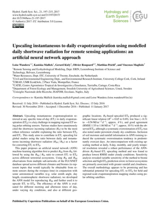
![198 L. Wandera et al.: An Artificial Neural Network approach
1 Introduction
Satellite-based mapping and monitoring of daily regional
evapotranspiration (ET hereafter; or latent heat flux, λE) is
considered to be a key scientific concern for multitudes of
applications including drought monitoring, water rights man-
agement, ecosystem water-use efficiency assessment, dis-
tributed hydrological modelling, climate change studies, and
numerical weather prediction (Anderson et al., 2015; Senay
et al., 2015; Sepulcre-Canto et al., 2014). ET variability dur-
ing the course of a day is influenced by changes in the ra-
diative energy being received at the surface (Brutsaert and
Sugita, 1992; Crago, 1996; Parlange and Katul, 1992), due
to soil moisture variability, particularly in the water deficit
landscapes, and also due to the stomatal regulation by vege-
tation.
One of the fundamental challenges in regional ET mod-
elling using polar orbiting satellites involves the upscaling of
instantaneous ET retrieved at any specific time-of-day (ETi
hereafter) to daily ET (ETd hereafter). For example, ETi re-
trieved from LANDSAT, ASTER and MODIS sensors typi-
cally represent ETi at a single snapshot of 10:00, 10:30 and
13:30 LT, which needs to be upscaled to daily timescale for
making this information usable to hydrologists and water
managers (Cammalleri et al., 2014; Colaizzi et al., 2006; Ryu
et al., 2012; Tang et al., 2013).
In order to accommodate the temporal scaling chal-
lenges encountered by remote-sensing-based ET models,
techniques have been proposed and applied by various re-
searchers to upscale ETi to ETd. These include: (1) the con-
stant evaporative fraction (EF) approach which assumes a
constant ratio between λE and net available energy (φ =
Rn −G, Rn is the net radiation and G is the ground heat flux)
during daytime [EF = λE/(Rn − G)] (Gentine et al., 2007;
Shuttleworth et al., 1989), (2) constant reference evapora-
tive fractions (EFr) method where the ratio of ETi between a
reference crop (typically grass measuring a height of 0.12 m
in an environment that is not water-limited) and an actual
surface is assumed to be constant during daytime, allowing
ETd to be estimated from the daily EFr (Allen et al., 1998;
Tang et al., 2013), (3) the constant global shortwave radia-
tion method (RS) where RS is the reference variable at the
land surface and it is assumed that the ratio of daily to in-
stantaneous shortwave radiation (RSd and RSi) values (i.e.
RSd / RSi) determines ETd to ETi ratio (Jackson et al., 1983;
Cammalleri et al., 2014), and (4) the constant extra-terrestrial
radiation method where the exo-atmospheric shortwave ra-
diation (RSTOA) is the reference variable and the ratio of
instantaneous to daily RSTOA (RSiTOA and RSdTOA) is as-
sumed to determine the ratio of ETd to ETi (Ryu et al., 2012;
Van Niel et al., 2012). These methods have been reviewed
and compared in different studies with the purpose of identi-
fying the most robust ETi to ETd upscaling approach based
on different datasets, time integrals, and varying sky condi-
tions (Cammalleri et al., 2014; Ryu et al., 2012; Tang et al,
2013, 2015; Van Niel et al., 2012; Xu et al., 2015).
Based on the previous studies, we find that the RSTOA ap-
proach performed consistently well at lower temporal resolu-
tion, namely 8-day to monthly scales (Ryu et al., 2012; Van
Niel et al., 2012), as well as under clear-sky conditions (Cam-
malleri et al., 2014), whereas the RS approach was identified
as the most preferred method for ETi to ETd conversion at a
higher temporal scale, i.e. daily timescale in addition to un-
der variable sky conditions (Cammalleri et al., 2014; Chávez
et el., 2008; Colaizzi, et al., 2006; Xu et al., 2015). Although
the EFr-based method produced comparable ETd estimates
to the RS-based method, however the dependence of EFr es-
timates on certain variables (e.g. daily net available energy,
φ, and wind speed) and the difficulty to characterise them
at the daily scale from single acquisition of polar orbiting
satellites (Tang et al., 2015) makes it a relatively less attrac-
tive method. Furthermore, the EF-based method appeared to
consistently underestimate ETd in all these studies.
The motivation for the current work is built on the conclu-
sions of Colaizzi et al. (2006), Chávez et al. (2008), Cam-
malleri et al. (2014), and Xu et al. (2015) that the ratio of
the instantaneous to daily RS incident on land surface is the
most robust reference variable explaining the ratio between
ETd and ETi among all the tested methods. This work aims
to contribute to ETi upscaling by first developing a method
for estimating RSd from any specific time-of-day RS infor-
mation (i.e. RSi) and, further, using RSd / RSi ratio as a fac-
tor for converting ETi to ETd. We develop an artificial neu-
ral network (ANN) machine learning algorithm (McCulloch
and Pitts, 1943) for estimating RSd. Although net radiation
(Rn) is more closely associated with ET, RS constitutes 80–
85 % of Rn (Mallick et al., 2015). Also from the remote-
sensing perspective, RSi is relatively easily retrievable irre-
spective of the sky conditions (Wang et al., 2015; Lopez and
Batlles, 2014), and its relationship to RSd is primarily gov-
erned by cloudiness (cloud fraction, cloud optical depth) and
astronomical variables (e.g. solar zenith angle, day length,
RSTOA). Given the information of cloudiness is also obtain-
able from remote sensing, we consider RS to be a robust vari-
able to explore ETi upscaling.
Even though this study is intended for remote sensing ap-
plication, we tested the method using meteorological and
surface energy balance flux measurements from eddy co-
variance (EC) system at the FLUXNET (Baldocchi et al.,
2001) sites mainly for the purpose of temporal consis-
tency. However, we evaluate the performance in consider-
ation with overpass time of polar orbiting satellites com-
monly used in operational ET mapping, namely MODIS and
LANDSAT. By choosing to use data distributed over differ-
ent ecosystems and climate zones, we are faced with two
problems: (1) changing cloud conditions across ecosystems
and (2) varying energy balance closure (EBC) requirements
for the fluxes in different ecosystems (Foken et al., 2006;
Franssen et al., 2010; Mauder and Foken, 2006; Wilson et
Hydrol. Earth Syst. Sci., 21, 197–215, 2017 www.hydrol-earth-syst-sci.net/21/197/2017/](data:image/gif;base64,R0lGODlhAQABAIAAAAAAAP///yH5BAEAAAAALAAAAAABAAEAAAIBRAA7)