
Recommended
More Related Content
Viewers also liked
More from Julianne Cox
More from Julianne Cox (13)
Recently uploaded
Recently uploaded (20)
We have been misled by a flawed world map for 500 years
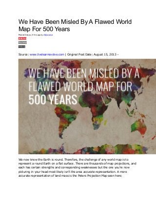
- 1. We Have Been Misled By A Flawed World Map For 500 Years Posted 3 days, 21 hrs ago by Satyapriya Articles Societal History 0 Source: www.livelearnevolve.com | Original Post Date: August 15, 2013 – We now know the Earth is round. Therefore, the challenge of any world map is to represent a round Earth on a flat surface. There are thousands of map projections, and each has certain strengths and corresponding weaknesses but the one you’re now picturing in your head most likely isn’t the area accurate representation. A more accurate representation of land mass is the Peters Projection Map seen here:
- 2. PETER’S PROJECTION WORLD MAP I find it absolutely astonishing that this information was not presented to me during education and studying Geography, the differences are overwhelming. Here’s a direct representation of the previously assumed factual map with the real flattened version:
- 4. THE TRUE SIZE OF AFRICA The map shows how Africa (30,3 million km²) is larger than the combination of China (9,6 million km²), the US (9,4 million km²), Western Europe (4,9 million km²), India (3,2 million km²) and Argentina (2,8 million km²), three Scandinavian countries and the British Isles (map gives no surface for these last two areas). Map Source The Peters Projection world map is one of the most stimulating, and controversial, images of the world. When this map was first introduced by historian and cartographer Dr. Arno Peters at a Press Conference in Germany in 1974 it generated a firestorm of debate. The first English-version of the map was published in 1983, and it continues to have passionate fans as well as staunch detractors.
- 5. This map was featured in “The West Wing,” but map dishonesty is anything but fictional. Check out this clip to get an accurate look at the size of Africa and explanation as to why it’s been like this: Favoured by National Geographic if one 2D representation of the world is to be used in the media and integrated into education then perhaps this, the winkel tripel projection is the most accurate because it displays both curvature and a truer land mass:
- 7. Written by Sam Austin of www.livelearnevolve.com About the Author Primarily a Creative Designer/Photographer, I opted to pursue the development of an accessible platform that raises awareness on more meaningful information that could genuinely benefit others (seems to be a niche market in mass news/media outlets). Always keen to expand my perspectives and share experiences of self discovery with the like minded so feel free to connect.