SlideShare a Scribd company logo
1 of 12
Download to read offline
2022 STATE OF BUZZARDS BAY
Pollution Reductions
Drive Improvements
Climate Change
Moving the Goal Post
46
OUT OF 100
www.savebuzzardsbay.org
The Buzzards Bay Coalition
is a membership-supported
non-profit organization
dedicated to the restoration,
protection and sustainable
use and enjoyment of
Buzzards Bay and its
watershed. Founded in 1987,
the Coalition works to
improve the health of the
Bay ecosystem for all through
education, conservation,
research and advocacy.
Learn more at:
ON THE COVER
Sunlight streaming
through clear water to
reach lush eelgrass beds
and their resident bay
scallops. It’s hard to
imagine an image that
better reflects a restored
Buzzards Bay. Such a
Bay is only possible with
low pollution levels and
healthy watershed forests,
streams and wetlands.
photo (cover and right):
Romona Robbins
2015 2022
POLLUTION
Nitrogen 53 57
Bacteria 62 59
Toxics 52 55
WATERSHED HEALTH
Forests 77 76
Streams 71 71
Wetlands 60 59
LIVING RESOURCES
Eelgrass 23 25
Bay Scallops 2 2
River Herring 2 1
OVERALL SCORE (100 = Excellent) 45 465
Improvement
How We Create our Report
To create the State of the Bay report, the
Buzzards Bay Coalition collaborates with
scientists and land use experts to examine the
best available current and historical indicators
in three categories: Pollution, Watershed Health,
and Living Resources. Beginning in 2003, we
have returned every few years to assess these
same indicators as a consistent method for
tracking progress or degradation over time.
The current State of the Bay is measured
against the healthiest Buzzards Bay in recorded
history — the natural abundance experienced
by explorer Bartholomew Gosnold and his crew
in 1602. The Bay that Gosnold experienced was
largely unspoiled by harmful human activities and
rates 100 on our scale. Today, a restored, healthy
Buzzards Bay would likely score a 75.
In examining the best available information
for each of the indicators, we actively seek
additional data and more accurate sources of
information to improve on this report on each
iteration. The most reliable and consistent
source of information is that collected through
the Coalition’s own baywide Water Quality
Monitoring Program, now in its 31st consecutive
year. That data, collected in partnership with the
Marine Biological Laboratory’s Ecosystems Center
in Woods Hole, serves as the foundation of the
Nitrogen Score.
Originally planned as a 2020 report, the Covid-19
Pandemic delayed some important data sets
upon which this report relies. NOAA and EPA
mussel tissue data used to calculate the Toxic
Score was delayed, but was ultimately acquired
in 2022. The worst data loss came from the MA
Department of Environmental Protection which
has failed to update its analysis of wetlands loss
for nine years now. That data had been expected
in 2020, but was postponed during Covid and
has yet to be released.
We are grateful to all who contributed to this
report. Joe Costa, Executive Director of the
Buzzards Bay National Estuary Program helped
with the Bacteria and Eelgrass scores this year.
Paul Lefebvre, GIS Specialist at the Woodwell
Climate Research Center, developed the Forest
and Stream Buffer score. Chris Neill, Senior
Scientist at the Woodwell Climate Research Center
and Chair of the Coalition’s Science Advisory
Committee, provided invaluable guidance and
support. In addition, several agencies provided
data for this report including the Massachusetts
Division of Marine Fisheries, Massachusetts
Department of Environmental Protection, US
Environmental Protection Agency, National
Oceanic and Atmospheric Administration, and
Alewives Anonymous. John Rogan of Clark
University’s Human-Environment Regional
Observatory provided data on areas of forest
cleared for solar development.
The Chesapeake Bay Foundation’s annual State of
the Bay report serves as a model for our report.
Decline
No Significant
Change
2022 STATE OF BUZZARDS BAY
Suggested Citation: Rasmussen, M., Jakuba, R.W., Costa, J.E., Lefebvre, P. (2022); 2022 State of Buzzards Bay. 12pp.
Since the beginning of our State of the Bay reports in 2003, we have
documented troubling trends in the health of Buzzards Bay. That year’s
assessment yielded a score of 48 out of 100. Since then, the score has
been stalled at 45 for the last three reports. In all those cases, the story
behind that flat line remained the same: slow improvements in things
like toxics and bacteria pollution were being eliminated by the impact
of expanding nitrogen pollution.
But then in 2015, nitrogen pollution stopped getting worse, and we
stopped losing eelgrass beds as well. We hoped that this encouraging
pause was signaling that we may have reached the floor on nitrogen
pollution getting worse in the Bay.
Pollution Reductions Are Driving Improvements …
Six years on, the data on nitrogen pollution is even better than expected with the state of pollution in 2018 recovering to
levels not seen since 1995 (before declining slightly in the next three years). This is not just great news for improved water
clarity and healthy oxygen levels. The conditions created by reduced nitrogen pollution can also be seen in expansion of
eelgrass beds throughout the Bay and even a bay scallop harvest in 2018-18 on a scale not seen in more than a decade.
No other form of pollution does more harm to Buzzards Bay and all its harbors and coves than nitrogen, and its 4-point
improvement in this State of the Bay should be celebrated. It is the result of years of local efforts to clean up septic
systems and old sewer plants as well as state and federal gains in reducing the amount of nitrogen that falls on the Bay
from air pollution.
The other pollution reduction to be celebrated is the continued decline of toxics in the Bay. A 3-point improvement in
the amount of toxins detected in the Bay’s delicate blue mussel populations is a result of the ongoing cleanup of legacy
industrial pollution and modern restrictions on the use of toxics in agricultural, industrial and home products.
… but Climate Change is Moving the Goal Post.
Just when it looks like we’re beginning to address nitrogen pollution — the driving factor behind Bay declines over the past
30 years — climate change is moving the goal post and changing the Bay restoration landscape. Two factors that were
not even recognized in the data when we started these assessments in 2003 are taking over as the greatest drivers of Bay
decline — warmer water and rising sea levels.
Warmer water in the Bay — up 4 degrees Fahrenheit since the mid 1990s — now allows bacteria to persist longer leading
to shellfish bed and beach closures, and extends the season of biological activity in the Bay encouraging algae to bloom
on lower levels of nitrogen. In effect, we need to remove more nitrogen in a warmer Bay to see the same water
quality improvements.
And rising sea levels are proving to be the Achilles heel of the Bay’s vital salt marshes, which are eroding and drowning
under higher tides and higher base sea level. This is the most disappointing new challenge identified in these data.
A final point. As a regional assessment, the State of Buzzards Bay scores can mask local variations in the data.
Not all corners of the Bay improved and others, like the Westport River, saw exceptional gains.
Improved 2022 State of Buzzards Bay score reflects significant
reductions in nitrogen and toxic pollution, as well as new challenges
facing the Bay due to climate change.
2022 STATE OF BUZZARDS BAY | 1
THE BOTTOM LINE
Nitrogen 57 (+4 from 2015)
No source of pollution has done more to damage
the health of Buzzards Bay’s harbors, coves and tidal
rivers over the past 40 years than nitrogen pollution.
Between 1992 and 2013, nitrogen entering the Bay
primarily from residential septic systems, but also
from older wastewater treatment plants, air pollution
from cars and power plants, and fertilizers, resulted
in decreasing Bay Health scores documented by the
Coalition’s Baywatchers Water Quality Monitoring
Program. The downward trend pointed to a bleak
future for our region’s coastal waters. And then, the
decline slowed and there was enough optimism to
label the status as an encouraging pause in nitrogen
pollution in our 2015 State of the Bay report.
The past six years have seen that ‘encouraging
pause’ converted to a dramatic rally. In 2021,
the baywide Nitrogen Score has made a 4-point
improvement — the largest change in any of the
State of the Bay indicators. Across the Bay,
Nitrogen levels are down and water clarity and
sunlight penetration are improved. Closely-related
Eelgrass and Bay Scallop populations (discussed
later in this report) have also benefitted.
The score of 57 is based on the 5-year running
average Bay Health Index scores across 180 locations
from the Westport Rivers to Woods Hole representing
the Bay’s major harbors, coves and tidal rivers.
Between 2013 and 2018 there was a steady increase
in water quality that then leveled over the last three
years. As with any regional average, it is important
to note that there are variations between embayments.
Some places are doing worse, but many more are
doing better.
2022 SCORE:
Towns across the Bay are taking steps to reduce nitrogen
pollution, and those actions are working to reverse the
Bay’s decline. Since our last report, wastewater treatment
plant upgrades in Marion and West Falmouth have been
implemented, towns are doing more to require that
new developments utilize the best nitrogen-removal
technologies for septic systems, and cranberry farmers
continue to improve bog construction methods and
practices that reduce fertilizer losses. We have also
benefitted from federal clean air policies which have
dramatically reduced the amount of nitrogen compounds
(i.e., nitrous oxides and ammonia) falling on the Bay from
car exhaust pipes and old fossil fuel power plants (see
graph). The last coal-fired power plant in Massachusetts
located at Brayton Point in Somerset, just 5 miles from
the western edge of the Buzzard Bay watershed, was
shut down in 2017 ending more than 50 years of pollution
entering the Bay.
H
o
w
i
s
N
i
t
r
o
g
e
n
A
f
f
e
c
t
i
n
g
Y
o
u
r
L
o
c
a
l
H
a
r
b
o
r
o
r
C
o
v
e
?
B
a
y
H
e
a
l
t
h
I
n
d
e
x
(
5
-
y
r
r
u
n
n
i
n
g
a
v
e
r
a
g
e
)
D
e
g
r
a
d
e
d
N
a
s
k
e
t
u
c
k
e
t
R
i
v
e
r
E
s
t
u
a
r
y
A
c
u
s
h
n
e
t
R
i
v
e
r
E
s
t
u
a
r
y
S
n
u
g
H
a
r
b
o
r
,
W
e
s
t
F
a
l
m
o
u
t
h
I
n
n
e
r
S
l
o
c
u
m
s
R
i
v
e
r
W
e
s
t
p
o
r
t
R
i
v
e
r
,
U
p
p
e
r
E
a
s
t
B
r
a
n
c
h
A
g
a
w
a
m
R
i
v
e
r
E
s
t
u
a
r
y
I
n
n
e
r
W
e
w
e
a
n
t
i
c
R
i
v
e
r
M
a
t
t
a
p
o
i
s
e
t
t
R
i
v
e
r
M
o
u
t
h
I
n
n
e
r
L
i
t
t
l
e
R
i
v
e
r
I
n
n
e
r
A
p
p
o
n
a
g
a
n
s
e
t
t
B
a
y
I
n
n
e
r
A
u
c
o
o
t
C
o
v
e
W
e
s
t
p
o
r
t
R
i
v
e
r
,
I
n
n
e
r
E
a
s
t
B
r
a
n
c
h
R
a
n
d
s
H
a
r
b
o
r
E
e
l
P
o
n
d
,
M
a
t
t
a
p
o
i
s
e
t
t
O
u
t
e
r
L
i
t
t
l
e
R
i
v
e
r
E
e
l
P
o
n
d
,
B
o
u
r
n
e
W
e
s
t
E
n
d
P
o
n
d
,
C
u
t
t
y
h
u
n
k
H
a
m
m
e
t
t
C
o
v
e
O
u
t
e
r
W
e
w
e
a
n
t
i
c
R
i
v
e
r
I
n
n
e
r
N
e
w
B
e
d
f
o
r
d
H
a
r
b
o
r
W
i
l
d
H
a
r
b
o
r
R
i
v
e
r
B
r
o
a
d
M
a
r
s
h
R
i
v
e
r
B
a
c
k
R
i
v
e
r
I
n
n
e
r
P
o
c
a
s
s
e
t
H
a
r
b
o
r
P
o
c
a
s
s
e
t
R
i
v
e
r
I
n
n
e
r
W
a
r
e
h
a
m
R
i
v
e
r
W
e
s
t
F
a
l
m
o
u
t
h
H
a
r
b
o
r
H
e
a
d
L
i
t
t
l
e
S
i
p
p
e
w
i
s
s
e
t
t
M
a
r
s
h
A
p
p
o
n
a
g
a
n
s
e
t
t
B
a
y
,
M
i
d
-
H
a
r
b
o
r
I
n
n
e
r
S
i
p
p
i
c
a
n
H
a
r
b
o
r
O
u
t
e
r
S
l
o
c
u
m
s
R
i
v
e
r
POOR FAIR
2 | BUZZARDS BAY COALITION
POLLUTION
BAY-WIDE NITROGEN SCORE
2021
2015
1
0
1
7
2
5
2
4
1
9
4
1
2
8
3
4
3
2
3
0
3
9
2
5
4
5
2
6
3
8
4
2
4
3
3
3
4
5
4
5
4
1
4
9
3
7
6
2
5
2
5
3
3
7
4
4
4
8
5
1
4
8
3
1
7
2
5
2
7
2
8
2
8
2
9
2
9
3
1
3
4
3
5
3
6
3
9
4
0
4
0
4
0
4
1
4
2
4
2
4
3
4
8
4
8
5
0
5
0
5
1
5
1
5
3
5
3
5
3
5
3
5
5
70
65
60
55
50
45
40
1
9
9
0
1
9
9
5
2
0
0
0
2
0
0
5
2
0
1
0
2
0
1
5
2
0
2
0
2
0
2
5
2003
2021
2013
difference. The trend in chlorophyll concentrations,
however, indicates that while water quality responded
to decreases in nitrogen, chlorophyll concentrations
have remained higher than they were at similar nitrogen
concentrations 20 years ago, which shows the challenge
that climate change poses.
Higher bay water temperatures help to fuel algal
blooms and keep dissolved oxygen concentrations
lower, so nitrogen concentrations will need to keep
declining if we are to restore water quality. In essence,
climate change is moving the goal post on Bay recovery.
In a world of warmer water, more nitrogen pollution
must be removed from the Bay to get the related
positive responses in lower algae (clearer water) and
greater oxygen (more fish and shellfish) than before.
There is an up to 10-year lag between reductions in
emissions from the source and improved water quality
in nearby waterways. Adapted from Lloret et al. 2022
(doi.org/10.1016/j.ecss.2022.108057)
Today, by far the largest source of nitrogen to most
Buzzards Bay harbors and coves remains residential
septic systems. Even new, properly functioning
Title 5 septic systems do little to prevent nitrogen
pollution. Much work lies ahead to connect more
homes to modern wastewater treatment plants, and
where that’s not possible, to enhanced nitrogen-
reducing septic systems.
The nitrogen data also contain a warning for the future.
Chlorophyll concentrations (a measure of algae in
the water) in the Bay were the highest ever recorded
between 2005 and 2013 and while somewhat lower
since 2014, they are generally still higher than the first
ten years of the Baywatchers Program. This observation
is a reason for concern. The steady decrease in nitrogen
concentrations shows clearly that we can make a
O
u
t
e
r
N
e
w
B
e
d
f
o
r
d
H
a
r
b
o
r
L
i
t
t
l
e
B
a
y
,
F
a
i
r
h
a
v
e
n
I
n
n
e
r
W
i
l
d
H
a
r
b
o
r
H
e
n
C
o
v
e
O
u
t
e
r
A
p
p
o
n
a
g
a
n
s
e
t
t
B
a
y
S
q
u
e
t
e
a
g
u
e
H
a
r
b
o
r
W
e
s
t
p
o
r
t
R
i
v
e
r
,
W
e
s
t
B
r
a
n
c
h
O
u
t
e
r
W
a
r
e
h
a
m
R
i
v
e
r
L
i
t
t
l
e
B
u
t
t
e
r
m
i
l
k
B
a
y
F
i
d
d
l
e
r
s
C
o
v
e
I
n
n
e
r
R
e
d
B
r
o
o
k
H
a
r
b
o
r
S
h
e
l
l
P
o
i
n
t
B
a
y
,
O
n
s
e
t
M
a
r
k
s
C
o
v
e
W
e
s
t
F
a
l
m
o
u
t
h
H
a
r
b
o
r
,
M
i
d
-
H
a
r
b
o
r
I
n
n
e
r
M
a
t
t
a
p
o
i
s
e
t
t
H
a
r
b
o
r
I
n
n
e
r
C
l
a
r
k
s
C
o
v
e
O
u
t
e
r
S
i
p
p
i
c
a
n
H
a
r
b
o
r
W
e
s
t
p
o
r
t
R
i
v
e
r
,
O
u
t
e
r
E
a
s
t
B
r
a
n
c
h
O
u
t
e
r
C
l
a
r
k
s
C
o
v
e
B
u
t
t
e
r
m
i
l
k
B
a
y
P
h
i
n
n
e
y
s
H
a
r
b
o
r
E
a
s
t
R
i
v
e
r
,
O
n
s
e
t
B
l
a
n
k
e
n
s
h
i
p
C
o
v
e
O
u
t
e
r
W
e
s
t
F
a
l
m
o
u
t
h
H
a
r
b
o
r
I
n
n
e
r
O
n
s
e
t
B
a
y
O
u
t
e
r
R
e
d
B
r
o
o
k
H
a
r
b
o
r
O
u
t
e
r
P
o
c
a
s
s
e
t
H
a
r
b
o
r
N
a
s
k
e
t
u
c
k
e
t
B
a
y
A
u
c
o
o
t
C
o
v
e
,
M
i
d
-
H
a
r
b
o
r
O
u
t
e
r
M
a
t
t
a
p
o
i
s
e
t
t
H
a
r
b
o
r
H
i
l
l
e
r
s
C
o
v
e
W
e
s
t
p
o
r
t
R
i
v
e
r
I
n
l
e
t
M
e
g
a
n
s
e
t
t
H
a
r
b
o
r
O
u
t
e
r
O
n
s
e
t
B
a
y
O
u
t
e
r
A
u
c
o
o
t
C
o
v
e
C
u
t
t
y
h
u
n
k
P
o
n
d
I
n
n
e
r
Q
u
i
s
s
e
t
t
H
a
r
b
o
r
P
e
n
i
k
e
s
e
I
s
l
a
n
d
O
u
t
e
r
Q
u
i
s
s
e
t
t
H
a
r
b
o
r
H
e
a
l
t
h
y
EXCELLENT
FAIR 2022 STATE OF BUZZARDS BAY | 3
5
0
6
9
4
6
5
1
5
7
5
7
4
7
6
0
5
7
6
1
4
3
5
8
6
4
6
1
6
3
4
3
6
4
5
1
5
6
6
2
6
6
6
7
7
0
6
4
7
0
5
6
7
7
7
8
7
4
7
5
8
0
6
4
7
2
7
6
7
7
8
1
8
0
9
6
8
6
5
6
5
6
5
7
5
7
5
7
5
8
5
9
6
0
6
1
6
1
6
3
6
3
6
3
6
5
6
6
6
7
6
7
6
8
6
9
6
9
6
9
7
2
7
2
7
4
7
5
7
6
7
6
7
6
7
7
7
7
8
1
8
2
8
3
8
3
8
4
8
6
8
9
9
0
9
1
20
15
10
5
0
TOTAL
N
DEPOSITION
(kg
N
ha
-1
yr
-1
)
1
9
7
0
1
9
8
0
1
9
9
0
2
0
0
0
2
0
1
0
2
0
2
0
Massachusetts
Cape Cod
DECLINES IN NITROGEN IN AIR POLLUTION
4 | BUZZARDS BAY COALITION
Bacteria 59 (-3 from 2015)
Toxics 55 (+3 from 2015)
Since the early-1990s, communities around the Bay
have worked hard to improve sewage treatment,
identify illegal septic hookups, and tie more homes
into municipal wastewater plants. As a result, today our
swimming beaches are much safer, and more shellfish
beds are open to harvest. But the work is far from
complete — and becoming more challenging.
A 3-point drop in the Bacteria score is the largest ever
reported and marks a troubling new challenge facing
all corners of the Bay. A near steady source of improve-
ment between 1990 and 2010, the trend of reopening
shellfish beds has reversed over the past four years.
Our bacteria score is calculated by tracking the number
of acres of shellfish beds closed to harvest on July 1st of
every year. Between 2015 and 2021, the number of acres
open on that day has declined by 1,656 acres.
Most notable is that this drop in score does not appear
to be due to actual increases in the discharge of
bacterial contamination. The decline in score is partially
due to more stringent federal regulation that now
requires closing more shellfish beds around marinas and
mooring fields as a precaution. This change accounts
for 56% of the increased closures. A second reason
is more of a concern. The combination of continued
nitrogen pollution now exacerbated by ever warmer
water in the Bay helps bacteria persist longer than
before. We see the same effect at play in what are now
more frequent late summer beach closures when the
Bay is at its warmest.
This is another case of climate change moving the
goalpost. Greater reductions of pollution are now
required to produce water quality benefits.
The reduction of toxic pollution continues to be one of
the brightest spots in this year’s State of Buzzards Bay
report thanks to stricter laws, improving farming and
industrial technologies, and better enforcement.
Sources of toxic pollution to Buzzards Bay include oil
spills, discharges from wastewater treatment plants,
household hazardous wastes, pesticides, and stormwater
runoff. In addition, “legacy” contaminants — pollution
from past practices like the dumping of PCBs in New
Bedford Harbor from 1950-1980 — continue to demand
cleanup attention and funding.
To assess the extent of toxic pollution in the Bay, we use
data collected from blue mussels which easily absorb
and bioaccumulate toxics and reflect the quality of
the waters surrounding them. Our score is based on a
combination of monitoring of PCBs in mussels in New
Bedford Harbor by the US EPA (25%) and the NOAA
Mussel Watch Program’s monitoring of 42 different
contaminants (10 metals, 16 PAHs, 16 organochlorine
pesticides) at locations throughout Buzzards Bay (75%).
In this year’s assessment, the New Bedford Harbor PCB
portion of the score improved, but the increase was not
as large as it was between either of the two previous
reports in 2011 and 2015. The most recent data available
from EPA, however, was from 2018, and removal of
contaminated sediments in the Harbor has accelerated
due to federal Covid recovery funding in recent years.
The level of toxic pollution elsewhere in Buzzards Bay
remains much lower. 2021 Mussel Watch data were
analyzed from sampling stations at the Cape Cod
Canal, off West Falmouth, and at Gooseberry Island
in Westport. Levels of pollution in the metals class
remained the same over our 2015 report, but reductions
in the levels of PAHs (from burning of coal, oil and
gasoline) and organochlorine pesticides (historically
used in agriculture) drove the improvements.
BUZZARDS BAY SHELLFISH CLOSURES, JULY 1
ACRES
CLOSED
14,000
12,000
10,000
8,000
6,000
4,000
2,000
0
1
9
9
1
1
9
9
3
1
9
9
5
1
9
9
7
1
9
9
9
2
0
0
1
2
0
0
3
2
0
0
5
2
0
0
7
2
0
0
9
2
0
1
1
2
0
1
3
2
0
1
5
2
0
1
7
2
0
1
9
2
0
2
1
Closures increased all
years since 2015.
2022 SCORE:
2022 SCORE:
Forests 76 (-1 from 2015)
WATERSHED HEALTH
2022 STATE OF BUZZARDS BAY | 5
Compared to other East Coast estuaries like
Narragansett Bay (42% forested), Long Island Sound
(56%) and the Chesapeake (60%), Buzzards Bay has
an important distinction: its large area of watershed
forest. The simple fact that 76% of our watershed
remains forested is one of the key secrets behind the
Bay’s relative good health.
The 2022 forest score of 76 represents a decline of one
point over 2015. A disappointing 1,863 acres of forest
were lost to development since our last report. Land
Use analysts at the Woodwell Climate Research Center
utilized aerial imagery to determine the extent of forest
in our region at an extremely high level of resolution.
Forests protect clean water in our bay, streams, ponds
and drinking water supplies in countless ways. The
soils in forests capture rainfall, filtering out harmful
pollution before slowly releasing the water into streams,
wetlands and groundwater. Tree roots hold soil in place
preventing erosion and sediment pollution. And, forests
store carbon, keep our air clean and cooler, and shade
coldwater streams where native brook trout and other
wildlife thrive.
Of the 1,863 acres of forest lost to development since
2014, two-thirds of the loss was attributed to largely
low density, sprawl residential development fueled by
the hottest real estate market in a decade. The other
one-third — 604 acres — was destroyed by a frustrating
new practice in our watershed — the clearing of mature
forest for solar farms. The production of renewable
energy from solar photovoltaics is an important part
of decreasing dependence on fossil fuels and fighting
climate change. But clearing Bay-saving forests is not
the way forward when our region is full of alternative,
already altered sites.
Stream Buffers 71 no change
No part of our landscape contributes more to protecting
clean water than Stream Buffers - the forested areas that
grow along the more than 700 miles of streams flowing
through the Buzzards Bay watershed. The first 200 feet
of trees and plants along either side of a stream are the
most important to protect due to their ability to capture,
absorb and remove an amazing amount of pollution
before it ever reaches our waterways.
The Stream Buffer score remains steady at 71, meaning
that local Conservation Commissions in all Bay towns
continue to hold their own to prevent development
within 200 feet of the Bay’s small streams. Between
2014-2021, just 52 acres of natural cover was lost in this
critical band throughout the Bay watershed.
42% of the loss (22 acres) of Stream Buffer over that
period was due to solar development.
As housing developments, farms and commercial
buildings have replaced natural stream buffers, the health
of our water has suffered. Between 1620-1995, 29% of
Buzzards Bay’s watershed stream buffers — nearly 9,000
acres — were lost to poorly planned development.
The relative success in maintaining our Stream Buffer
area over the past 25 years can be largely attributed
to the MA Rivers Protection Act — a targeted
amendment to the state Wetlands Act. Under the law,
the first 100 feet along streams are usually protected,
the second 100 feet require permitting but can continue
to face development pressure. Local Conservation
Commissions in all Bay towns administer this law on a
project-by-project basis.
2022 SCORE:
2022 SCORE:
Wetlands 59 (-1 from 2015)
No component of the Bay ecosystem assessed by this
report is under more pressure and accelerating decline
than the Bay’s wetlands.
Overall, an estimated 40% of the Bay’s original wetlands
have been filled, drained, or built upon since European
settlement. These rich habitats are powerful pollution
filters that can absorb as much as 90% of the nitrogen
flowing across the landscape from nearby development.
They are, in effect, the Bay’s kidneys — and we can’t
afford to lose any more of them.
Layers of local, state, and federal laws overlap to protect
the Bay watershed’s salt marshes, wooded swamps, and
freshwater wetlands. Nevertheless, between 1997-2012
we lost 265 acres of wetlands at an average annual rate
of 10-14 acres since 2001. The MA DEP issued an analysis
of wetland destruction every 3-4 years during that time,
but has failed to produce a new analysis for the past nine
years. Carrying forward that previous loss rate, it’s pos-
sible that an additional 90-125 acres of wetlands were
lost due to traditional land development in that period.
The most serious and troubling losses of wetlands
today, however, no longer come from bulldozers and
backhoes. A new silent form of human destruction
is taking our most precious wetlands — our salt
marshes — away from us. Climate change-driven sea
level rise is literally drowning salt marshes in place and
already at an alarming rate. These factors produced
the first 1-point drop in the Wetlands score in the
assessment’s history.
Of the Bay’s nearly 5,000 acres of saltmarsh,
approximately 7% of them — were lost between 2001
and 2019. This new data are not a projection, but rather
the real-world findings at twelve study sites — from
Westport to Falmouth — featuring a wide range of
marsh configurations. Some marshes studied, like those
on Mattapoisett Neck, saw dramatic losses of 23% of
their area.
The terrible driver here is accelerating sea level rise and
it will only get worse in the decades ahead. The official
Massachusetts Coastal Flood Risk Model projects that
sea-level in the Bay will increase by 1.27 feet over 2008
levels by 2030; 2.57 feet by 2050; and nearly 8 feet
by 2100. Under these water levels, analysis contained
in the 2022 State of the Coast report by The Trustees
of Reservations projects that by 2050 Westport will
lose 48% of its salt marshes (including all its island
marshes), Dartmouth 30%, Bourne 28%, Marion 21%, and
Mattapoisett and Falmouth 17% each.
Scientists and natural resource managers across
southern New England are scrambling right now to
identify stop-gap measures that can be deployed to slow
the rate of salt marsh loss and to preserve immediately
adjacent coastal areas where marshes may migrate
inland as the sea rises. These efforts are vital, but not as
important as halting the world’s reliance on fossil fuels
which continues to destroy the Bay ecosystem.
10 | BUZZARDS BAY COALITION
8 | BUZZARDS BAY COALITION
6 | BUZZARDS BAY COALITION
2022 SCORE:
Eelgrass 25 (+2 from 2015)
LIVING RESOURCES
If you want to track the spread of nitrogen pollution in
your own corner of Buzzards Bay, watch the eelgrass.
This rooted, underwater plant grows in meadows along
the bottom of the Bay’s harbors, coves and tidal rivers
in areas with clear water.
But when nitrogen pollution increases, it fuels the
growth of algae that reduces water clarity. Without
enough sunlight reaching the bottom, eelgrass
dies — just like a shaded house plant. And those species
that depend on eelgrass — juvenile fish, blue crabs, and
bay scallops — begin to vanish too. But when water
quality improves, eelgrass has consistently shown its
ability to naturally recover.
Like the 2021 Nitrogen Pollution score, eelgrass
coverage increased by 2 points in the past six years.
Overall, eelgrass meadows in Buzzards Bay increased
552 acres between 2015 and 2021. The change was
documented through analysis by the Buzzards Bay
National Estuary Program of maps of eelgrass
created from aerial images and field confirmation
by MassDEP.
There are a few areas that stand-out in this eelgrass
recovery story. Most notable, more than half of all new
eelgrass acres resulted from a dramatic expansion in
the Westport Rivers, particularly in the West Branch
which added 201 acres. And, a fifth of new eelgrass
since 2015 occurred along the coast just outside of
embayments where depths remain shallow, but water
quality benefits more from open exchange with the
cleaner open bay.
The area of greatest eelgrass decline was in
Mattapoisett Harbor which has lost 51 acres since 2015.
0
2,500
5,000
7,500
10,000
12,500
15,000
0
3,000
6,000
9,000
1
9
9
6
1
9
9
8
2
0
0
0
2
0
0
2
2
0
0
4
2
0
0
6
2
0
0
8
2
0
1
0
2
0
1
2
2
0
1
4
2
0
1
6
2
0
1
8
2
0
2
0
2
0
2
2
BUSHELS
ACRES
Eelgrass coverage
Bay scallops catch
51 YEARS OF EELGRASS AND BAY SCALLOPS (1970-2021)
2022 STATE OF BUZZARDS BAY | 7
2022 SCORE:
10 | BUZZARDS BAY COALITION
Bay Scallops 2 no change
Bay scallops were to Buzzards Bay what oysters historically were to
New York Harbor and the Chesapeake. But today, our once-abundant
and highly-valuable bay scallops have all but disappeared from most
parts of Buzzards Bay.
The Bay Scallop score was unchanged from 2015 and 2021. The
Massachusetts Division of Marine Fisheries reported an average
catch of roughly 1,300 bushels per year. That’s a stunning decline
from 1985, when nearly 70,000 bushels were harvested in Buzzards
Bay. But the story behind these deliciously fickle shellfish over the
past six years holds a glimmer of hope.
As the graph on previous page shows, bay scallops are notorious for
their natural boom and bust cycle, with banner harvest years followed
by years of almost no catch. As populations have crashed over the
past 35 years, harvests have remained consistently low. That was,
until 2017 when 4,675 bushels were landed, followed by 2,430 bushels
in 2018. Those harvests coincide with eelgrass recovery over the same
time period as these two species are closely linked. Bay scallops live
and grow among the shelter of eelgrass meadows and are dependent
on them for their survival.
Despite that brief flash of promise, State shellfish catch records for
2020 and 2021 ominously show zero landings of bay scallops for the
first time ever for Buzzards Bay.
Something good happened
in the West Branch… again.
Between 2015 and 2021, 305 acres,
or 55% of all new eelgrass growth
in Buzzards Bay, came from the
Westport Rivers, particularly the
West Branch which accounted for
201 of those acres.
This rapid expansion of eelgrass
meadow correlates with the
2017-19 bay scallop harvests — the
best in 18 years. In fact, the MA
Division of Marine Fisheries
reports that 95% of all bay scallop
catch in Buzzards Bay for those
years was out of Westport.
And it’s not the first time that
an unexpected boom year
came out of the West Branch or
Westport carried regional bay
scallop landings.
The last large bay scallop harvest
in the Bay was in 1985 when
66,169 bushels were landed. That
harvest followed a similar rapid
expansion of eelgrass in the West
Branch. A 1988 scientific paper
reported,“The cause of this
recent recolonization (in the West
Branch) is unclear, and this estuary
has undergone sizable fluctuations
in eelgrass abundance in the past.
These new beds accounted for at
least a 30% increase in eelgrass
cover in this estuary over one
year… Two years after the 1984
eelgrass expansion scallop catches
were the best in many years.”
(From Costa 1988)
8 | BUZZARDS BAY COALITION
Eelgrass recovery in the West Branch of the Westport River
2022 SCORE:
River Herring 2 no change
But there are signs that count trends on the
Mattapoisett may not be tracking the modest recovery
being seen on other Buzzards Bay rivers such as the
Monument (Cape Cod Canal) and Agawam River
(see graph). Nearby on the Taunton River and Cape
Cod there are also strong glimmers of hope. On the
Herring River in Harwich, Selectmen this year voted to
lift the 18-year moratorium on herring catch after
seeing a remarkable 1.2 Million fish counted there in
2019 — restored to a third of its historic run size.
This action followed a similar step taken in 2016 in
Middleboro on the Nemasket River — the largest run
in the state — following a number of high-count years.
River herring in Buzzards Bay remain in a state of
profound collapse with serious consequences for the
Bay ecosystem.
Today, only a tiny fraction of the historic numbers of
River Herring still make the journey from offshore, into
the Bay, and upstream to spawn in the watershed’s
freshwater rivers and ponds. This is very bad news for
the Bay’s sportfish such as Striped Bass and Bluefish
that rely on herring as well as for many bird species
including the region’s endangered Roseate Terns. River
herring, as a “foundation fish” at the base the food chain,
provide an important pillar in the Bay ecosystem. And
today that pillar remains in desperate need of rebuilding.
The historic decline of Buzzards Bay’s anadromous fish
like river herring can be traced first to the damming
of the Bay’s rivers, which prevent fish from swimming
upstream, but also to water quality degradation,
alterations to pond and stream flows, and offshore
bi-catch by commercial menhaden, mackerel and
Atlantic herring fishermen. A likely increasing challenge
in years ahead are the extreme drought years that
we are now experiencing due to climate change. Low
water levels caused many Bay streams to run dry in late
summer 2022 just as juvenile herring born upstream are
making their transition to saltwater.
With one of the longest datasets available, the
Mattapoisett River has served as our regional
benchmark for tracking the state of river herring
throughout Buzzards Bay. In 1921, state biologists
estimated the river’s run at 1.85 Million fish.
One Hundred years later, that figure sits at 1,886
fish — the lowest annual count ever recorded.
To put a finer point on these figures, fish in the
Mattapoisett are 0.001% of the count made exactly
a century ago.
COUNTS ON THE BAY’S LARGEST
HERRING RIVERS (2007-2022)
700,000
600,000
500,000
400,000
300,000
200,000
100,000
0
2
0
0
7
2
0
0
8
2
0
0
9
2
0
1
0
2
0
1
1
2
0
1
2
2
0
1
3
2
0
1
4
2
0
1
5
2
0
1
6
2
0
1
7
2
0
1
8
2
0
1
9
2
0
2
0
2
0
2
1
2
0
2
2
Mattapoisett River Agawam River Monument River
2022 SCORE:
Cleanup Wastewater
Nitrogen and bacteria pollution are both
rooted in inadequate residential wastewater
treatment. Nearly 2/3 of homes around the
Bay are served by septic systems which are
not designed to remove nitrogen pollution.
It is the pollution from these homes — from
us and our neighbors — at the root of the
Bay’s problems.
What Can Be Done:
· Connect existing and new homes to central
Wastewater Treatment Plants (WWTP).
Modern WWTPs consistently remove >90%
of nitrogen pollution and represent the best
solution available to our communities.
· Where central sewer systems are not possible,
such as in lower-density suburban and rural
areas, upgrade homes to individual
Denitrifying Septic Systems which remove
>50% of nitrogen.
· Wastewater infrastructure is expensive.
Support your town officials in long-term
financial planning and advocate
for grant funding from state
and federal agencies.
Preserve Forests and Wetlands
Preservation of the Bay watershed’s
most important forests, stream corridors
and wetlands is the most cost effective
way to protect the health of Buzzards Bay
as well as our drinking water. These are
the Bay’s natural filter systems and they
demand active effort to protect them in
the face of land development pressures.
What Can Be Done:
· Support your town’s active participation in
and funding of open space preservation.
· Town Conservation Commissions and the
MA DEP must enforce existing wetlands and
river protection laws. DEP’s release of
updated Wetlands Loss analysis is critical to
tracking compliance.
· State laws and local zoning should be
amended to redirect solar developments
away from forests to already disturbed and
built areas.
Taking Action to Improve the State of Buzzards Bay
Address Climate Change
So much of what needs to happen to
restore the Bay is controlled locally.
Wastewater and land use decisions happen
each week at our own Town Halls. While
that is not the case with curbing Climate
Change, we all must do our part to prevent
the warming and sea level rise that is
exacerbating nitrogen and bacteria
pollution in the Bay, devastating our vital
salt marshes and altering flows in our
streams. We all must accelerate our
community’s transition away from the
burning of fossil fuels and support clean,
renewable energy development.
MAIN OFFICE
114 Front Street, New Bedford, MA 02740
Join us and get involved at
www.savebuzzardsbay.org
Middleborough
Lakeville
Freetown
Fall River
Tiverton
Carver
Plymouth
Westport
Westport R.
Little
Compton
East Branch
West
Branch
Dartmouth
Apponagansett
Bay
Slocum R.
Cuttyhunk Is.
Clarks
Cove
New
Bedford
Acushnet R.
New Bedford
Inner Harbor
Fairhaven
Acushnet
Naushon Is.
Mattapoisett R.
Mattapoisett
Mattapoisett
Harbor
Nasketucket
Bay
Rochester
Weweantic R.
Marion
Aucoot
Cove
Sippican Harbor
Wareham R.
Wankinco R.
Wareham
Agawam R.
Onset
Bay
Buttermilk
Bay
Cape Cod
Bay
Buzzards Bay
Watershed
Boundary
Cape Cod
Canal
Falmouth
Bourne
Woods
Hole
Gosnold
Back R.
Pocasset R.
Wings
Cove Red Brook
Harbor
Wild
Harbor R.
Quissett
Harbor
West
Falmouth
Harbor
Wild
Harbor
Herring
Brook
Sandwich
Quicksand
Pond
B U Z Z A
R
D
S
B
A
Y
V I N E Y A
R
D
S
O
U
N
D
A few things everyone can do right now:
· Get involved in town government:
Volunteer to serve on Select, Planning,
Conservation and Health boards, vote at
Town Meeting, comment on projects that
affect the local environment.
· If a sewer connection is not possible in
your area, plan for the upgrade of your
own home septic system to one that
removes nitrogen.
· Reduce your use of lawn fertilizers and
only use organic garden products.
· Never dump paint, oil, cleaners or other
hazardous waste down sinks or
storm drains.
· If you own undeveloped land, talk with
the Buzzards Bay Coalition or a local
land trust about conservation options.
· Avoid eelgrass beds and sensitive salt
marsh edges when boating and shellfishing.

More Related Content

Similar to 2022 State of Buzzards Bay

Service solahart jakarta barat 087777888338
Service solahart jakarta barat 087777888338Service solahart jakarta barat 087777888338
Service solahart jakarta barat 087777888338hasian service
 
Service solahart jakarta barat 0821225416663
Service solahart jakarta barat   0821225416663Service solahart jakarta barat   0821225416663
Service solahart jakarta barat 0821225416663CV.Davinatama Service
 
Buzzards Bay Coalition 2013 Annual Report
Buzzards Bay Coalition 2013 Annual ReportBuzzards Bay Coalition 2013 Annual Report
Buzzards Bay Coalition 2013 Annual ReportBuzzards Bay Coalition
 
Service solahart jakarta barat 0821225416663
Service solahart jakarta barat   0821225416663Service solahart jakarta barat   0821225416663
Service solahart jakarta barat 0821225416663servicewika
 
Service solahart jakarta barat 0821225416663
Service solahart jakarta barat   0821225416663Service solahart jakarta barat   0821225416663
Service solahart jakarta barat 0821225416663servicesolahartl
 
Buzzards Bay Coalition 2014 Annual Report
Buzzards Bay Coalition 2014 Annual ReportBuzzards Bay Coalition 2014 Annual Report
Buzzards Bay Coalition 2014 Annual ReportBuzzards Bay Coalition
 
2011 Annual Report Final main version
2011 Annual Report Final main version2011 Annual Report Final main version
2011 Annual Report Final main versionRob Hancock
 
Stewards of the Bay: Lifestyles of Stewardship
Stewards of the Bay: Lifestyles of Stewardship  Stewards of the Bay: Lifestyles of Stewardship
Stewards of the Bay: Lifestyles of Stewardship Z8Y
 
Statement_HECHO Letter to House Committee on Natural Resources.pdf
Statement_HECHO Letter to House Committee on Natural Resources.pdfStatement_HECHO Letter to House Committee on Natural Resources.pdf
Statement_HECHO Letter to House Committee on Natural Resources.pdfHecho2
 
Grand Lake St. Marys Water Quality Update: 2021 in Review
Grand Lake St. Marys Water Quality Update: 2021 in ReviewGrand Lake St. Marys Water Quality Update: 2021 in Review
Grand Lake St. Marys Water Quality Update: 2021 in Reviewlakeimprovement
 
Climate Change - Our Challenge for the 21st Century by Jennifer Adkins, Direc...
Climate Change - Our Challenge for the 21st Century by Jennifer Adkins, Direc...Climate Change - Our Challenge for the 21st Century by Jennifer Adkins, Direc...
Climate Change - Our Challenge for the 21st Century by Jennifer Adkins, Direc...Kim Beidler
 
Climate Change in the Great Lakes Region
Climate Change in the Great Lakes RegionClimate Change in the Great Lakes Region
Climate Change in the Great Lakes RegionDavid Kinnear
 
Aggregateact 120611192330-phpapp02
Aggregateact 120611192330-phpapp02Aggregateact 120611192330-phpapp02
Aggregateact 120611192330-phpapp02Louisette Lanteigne
 

Similar to 2022 State of Buzzards Bay (20)

Service solahart jakarta barat 087777888338
Service solahart jakarta barat 087777888338Service solahart jakarta barat 087777888338
Service solahart jakarta barat 087777888338
 
Service solahart jakarta barat 0821225416663
Service solahart jakarta barat   0821225416663Service solahart jakarta barat   0821225416663
Service solahart jakarta barat 0821225416663
 
Service solahart depok 081380240365
Service solahart depok 081380240365Service solahart depok 081380240365
Service solahart depok 081380240365
 
Buzzards Bay Coalition 2013 Annual Report
Buzzards Bay Coalition 2013 Annual ReportBuzzards Bay Coalition 2013 Annual Report
Buzzards Bay Coalition 2013 Annual Report
 
Service solahart jakarta barat 0821225416663
Service solahart jakarta barat   0821225416663Service solahart jakarta barat   0821225416663
Service solahart jakarta barat 0821225416663
 
Service solahart jakarta barat 0821225416663
Service solahart jakarta barat   0821225416663Service solahart jakarta barat   0821225416663
Service solahart jakarta barat 0821225416663
 
Buzzards Bay Coalition 2014 Annual Report
Buzzards Bay Coalition 2014 Annual ReportBuzzards Bay Coalition 2014 Annual Report
Buzzards Bay Coalition 2014 Annual Report
 
2011 Annual Report Final main version
2011 Annual Report Final main version2011 Annual Report Final main version
2011 Annual Report Final main version
 
Stewards of the Bay: Lifestyles of Stewardship
Stewards of the Bay: Lifestyles of Stewardship  Stewards of the Bay: Lifestyles of Stewardship
Stewards of the Bay: Lifestyles of Stewardship
 
Formal Technical Report
Formal Technical ReportFormal Technical Report
Formal Technical Report
 
Ecosystems based water management: From innovation to practice
Ecosystems  based  water  management: From innovation to practice Ecosystems  based  water  management: From innovation to practice
Ecosystems based water management: From innovation to practice
 
Va milestone
Va milestoneVa milestone
Va milestone
 
Statement_HECHO Letter to House Committee on Natural Resources.pdf
Statement_HECHO Letter to House Committee on Natural Resources.pdfStatement_HECHO Letter to House Committee on Natural Resources.pdf
Statement_HECHO Letter to House Committee on Natural Resources.pdf
 
Grand Lake St. Marys Water Quality Update: 2021 in Review
Grand Lake St. Marys Water Quality Update: 2021 in ReviewGrand Lake St. Marys Water Quality Update: 2021 in Review
Grand Lake St. Marys Water Quality Update: 2021 in Review
 
Climate Change - Our Challenge for the 21st Century by Jennifer Adkins, Direc...
Climate Change - Our Challenge for the 21st Century by Jennifer Adkins, Direc...Climate Change - Our Challenge for the 21st Century by Jennifer Adkins, Direc...
Climate Change - Our Challenge for the 21st Century by Jennifer Adkins, Direc...
 
Dc milestone
Dc milestoneDc milestone
Dc milestone
 
2013 Bay Current
2013 Bay Current2013 Bay Current
2013 Bay Current
 
2013 Annual Report on Utah's Environment
2013 Annual Report on Utah's Environment2013 Annual Report on Utah's Environment
2013 Annual Report on Utah's Environment
 
Climate Change in the Great Lakes Region
Climate Change in the Great Lakes RegionClimate Change in the Great Lakes Region
Climate Change in the Great Lakes Region
 
Aggregateact 120611192330-phpapp02
Aggregateact 120611192330-phpapp02Aggregateact 120611192330-phpapp02
Aggregateact 120611192330-phpapp02
 

Recently uploaded

Soil pollution causes effects remedial measures
Soil pollution causes effects remedial measuresSoil pollution causes effects remedial measures
Soil pollution causes effects remedial measuresvasubhanot1234
 
VIP Call Girls Service Chaitanyapuri Hyderabad Call +91-8250192130
VIP Call Girls Service Chaitanyapuri Hyderabad Call +91-8250192130VIP Call Girls Service Chaitanyapuri Hyderabad Call +91-8250192130
VIP Call Girls Service Chaitanyapuri Hyderabad Call +91-8250192130Suhani Kapoor
 
Gwalior Call Girls 7001305949 WhatsApp Number 24x7 Best Services
Gwalior Call Girls 7001305949 WhatsApp Number 24x7 Best ServicesGwalior Call Girls 7001305949 WhatsApp Number 24x7 Best Services
Gwalior Call Girls 7001305949 WhatsApp Number 24x7 Best Servicesnajka9823
 
Green Marketing Strategies and Challenges
Green Marketing Strategies and ChallengesGreen Marketing Strategies and Challenges
Green Marketing Strategies and ChallengesDr. Salem Baidas
 
VIP Kolkata Call Girl Kalighat 👉 8250192130 Available With Room
VIP Kolkata Call Girl Kalighat 👉 8250192130  Available With RoomVIP Kolkata Call Girl Kalighat 👉 8250192130  Available With Room
VIP Kolkata Call Girl Kalighat 👉 8250192130 Available With Roomdivyansh0kumar0
 
VIP Call Girl Gorakhpur Aashi 8250192130 Independent Escort Service Gorakhpur
VIP Call Girl Gorakhpur Aashi 8250192130 Independent Escort Service GorakhpurVIP Call Girl Gorakhpur Aashi 8250192130 Independent Escort Service Gorakhpur
VIP Call Girl Gorakhpur Aashi 8250192130 Independent Escort Service GorakhpurSuhani Kapoor
 
(NANDITA) Hadapsar Call Girls Just Call 7001035870 [ Cash on Delivery ] Pune ...
(NANDITA) Hadapsar Call Girls Just Call 7001035870 [ Cash on Delivery ] Pune ...(NANDITA) Hadapsar Call Girls Just Call 7001035870 [ Cash on Delivery ] Pune ...
(NANDITA) Hadapsar Call Girls Just Call 7001035870 [ Cash on Delivery ] Pune ...ranjana rawat
 
Hi FI Call Girl Ahmedabad 7397865700 Independent Call Girls
Hi FI Call Girl Ahmedabad 7397865700 Independent Call GirlsHi FI Call Girl Ahmedabad 7397865700 Independent Call Girls
Hi FI Call Girl Ahmedabad 7397865700 Independent Call Girlsssuser7cb4ff
 
Sustainable Clothing Strategies and Challenges
Sustainable Clothing Strategies and ChallengesSustainable Clothing Strategies and Challenges
Sustainable Clothing Strategies and ChallengesDr. Salem Baidas
 
Call Girls South Delhi Delhi reach out to us at ☎ 9711199012
Call Girls South Delhi Delhi reach out to us at ☎ 9711199012Call Girls South Delhi Delhi reach out to us at ☎ 9711199012
Call Girls South Delhi Delhi reach out to us at ☎ 9711199012sapnasaifi408
 
See How do animals kill their prey for food
See How do animals kill their prey for foodSee How do animals kill their prey for food
See How do animals kill their prey for fooddrsk203
 
Poly-film-Prefab cover agricultural greenhouse-polyhouse structure.pptx
Poly-film-Prefab cover agricultural greenhouse-polyhouse structure.pptxPoly-film-Prefab cover agricultural greenhouse-polyhouse structure.pptx
Poly-film-Prefab cover agricultural greenhouse-polyhouse structure.pptxAgrodome projects LLP
 
办理(Victoria毕业证书)维多利亚大学毕业证成绩单原版一比一
办理(Victoria毕业证书)维多利亚大学毕业证成绩单原版一比一办理(Victoria毕业证书)维多利亚大学毕业证成绩单原版一比一
办理(Victoria毕业证书)维多利亚大学毕业证成绩单原版一比一z xss
 
办理学位证(KU证书)堪萨斯大学毕业证成绩单原版一比一
办理学位证(KU证书)堪萨斯大学毕业证成绩单原版一比一办理学位证(KU证书)堪萨斯大学毕业证成绩单原版一比一
办理学位证(KU证书)堪萨斯大学毕业证成绩单原版一比一F dds
 
原版定制copy澳洲詹姆斯库克大学毕业证JCU毕业证成绩单留信学历认证保障质量
原版定制copy澳洲詹姆斯库克大学毕业证JCU毕业证成绩单留信学历认证保障质量原版定制copy澳洲詹姆斯库克大学毕业证JCU毕业证成绩单留信学历认证保障质量
原版定制copy澳洲詹姆斯库克大学毕业证JCU毕业证成绩单留信学历认证保障质量sehgh15heh
 
9873940964 Full Enjoy 24/7 Call Girls Near Shangri La’s Eros Hotel, New Delhi
9873940964 Full Enjoy 24/7 Call Girls Near Shangri La’s Eros Hotel, New Delhi9873940964 Full Enjoy 24/7 Call Girls Near Shangri La’s Eros Hotel, New Delhi
9873940964 Full Enjoy 24/7 Call Girls Near Shangri La’s Eros Hotel, New Delhidelih Escorts
 

Recently uploaded (20)

Soil pollution causes effects remedial measures
Soil pollution causes effects remedial measuresSoil pollution causes effects remedial measures
Soil pollution causes effects remedial measures
 
Gandhi Nagar (Delhi) 9953330565 Escorts, Call Girls Services
Gandhi Nagar (Delhi) 9953330565 Escorts, Call Girls ServicesGandhi Nagar (Delhi) 9953330565 Escorts, Call Girls Services
Gandhi Nagar (Delhi) 9953330565 Escorts, Call Girls Services
 
VIP Call Girls Service Chaitanyapuri Hyderabad Call +91-8250192130
VIP Call Girls Service Chaitanyapuri Hyderabad Call +91-8250192130VIP Call Girls Service Chaitanyapuri Hyderabad Call +91-8250192130
VIP Call Girls Service Chaitanyapuri Hyderabad Call +91-8250192130
 
Gwalior Call Girls 7001305949 WhatsApp Number 24x7 Best Services
Gwalior Call Girls 7001305949 WhatsApp Number 24x7 Best ServicesGwalior Call Girls 7001305949 WhatsApp Number 24x7 Best Services
Gwalior Call Girls 7001305949 WhatsApp Number 24x7 Best Services
 
Call Girls In { Delhi } South Extension Whatsup 9873940964 Enjoy Unlimited Pl...
Call Girls In { Delhi } South Extension Whatsup 9873940964 Enjoy Unlimited Pl...Call Girls In { Delhi } South Extension Whatsup 9873940964 Enjoy Unlimited Pl...
Call Girls In { Delhi } South Extension Whatsup 9873940964 Enjoy Unlimited Pl...
 
Green Marketing Strategies and Challenges
Green Marketing Strategies and ChallengesGreen Marketing Strategies and Challenges
Green Marketing Strategies and Challenges
 
VIP Kolkata Call Girl Kalighat 👉 8250192130 Available With Room
VIP Kolkata Call Girl Kalighat 👉 8250192130  Available With RoomVIP Kolkata Call Girl Kalighat 👉 8250192130  Available With Room
VIP Kolkata Call Girl Kalighat 👉 8250192130 Available With Room
 
VIP Call Girl Gorakhpur Aashi 8250192130 Independent Escort Service Gorakhpur
VIP Call Girl Gorakhpur Aashi 8250192130 Independent Escort Service GorakhpurVIP Call Girl Gorakhpur Aashi 8250192130 Independent Escort Service Gorakhpur
VIP Call Girl Gorakhpur Aashi 8250192130 Independent Escort Service Gorakhpur
 
(NANDITA) Hadapsar Call Girls Just Call 7001035870 [ Cash on Delivery ] Pune ...
(NANDITA) Hadapsar Call Girls Just Call 7001035870 [ Cash on Delivery ] Pune ...(NANDITA) Hadapsar Call Girls Just Call 7001035870 [ Cash on Delivery ] Pune ...
(NANDITA) Hadapsar Call Girls Just Call 7001035870 [ Cash on Delivery ] Pune ...
 
Hi FI Call Girl Ahmedabad 7397865700 Independent Call Girls
Hi FI Call Girl Ahmedabad 7397865700 Independent Call GirlsHi FI Call Girl Ahmedabad 7397865700 Independent Call Girls
Hi FI Call Girl Ahmedabad 7397865700 Independent Call Girls
 
Sustainable Clothing Strategies and Challenges
Sustainable Clothing Strategies and ChallengesSustainable Clothing Strategies and Challenges
Sustainable Clothing Strategies and Challenges
 
Call Girls South Delhi Delhi reach out to us at ☎ 9711199012
Call Girls South Delhi Delhi reach out to us at ☎ 9711199012Call Girls South Delhi Delhi reach out to us at ☎ 9711199012
Call Girls South Delhi Delhi reach out to us at ☎ 9711199012
 
See How do animals kill their prey for food
See How do animals kill their prey for foodSee How do animals kill their prey for food
See How do animals kill their prey for food
 
Poly-film-Prefab cover agricultural greenhouse-polyhouse structure.pptx
Poly-film-Prefab cover agricultural greenhouse-polyhouse structure.pptxPoly-film-Prefab cover agricultural greenhouse-polyhouse structure.pptx
Poly-film-Prefab cover agricultural greenhouse-polyhouse structure.pptx
 
Hot Sexy call girls in Nehru Place, 🔝 9953056974 🔝 escort Service
Hot Sexy call girls in Nehru Place, 🔝 9953056974 🔝 escort ServiceHot Sexy call girls in Nehru Place, 🔝 9953056974 🔝 escort Service
Hot Sexy call girls in Nehru Place, 🔝 9953056974 🔝 escort Service
 
办理(Victoria毕业证书)维多利亚大学毕业证成绩单原版一比一
办理(Victoria毕业证书)维多利亚大学毕业证成绩单原版一比一办理(Victoria毕业证书)维多利亚大学毕业证成绩单原版一比一
办理(Victoria毕业证书)维多利亚大学毕业证成绩单原版一比一
 
办理学位证(KU证书)堪萨斯大学毕业证成绩单原版一比一
办理学位证(KU证书)堪萨斯大学毕业证成绩单原版一比一办理学位证(KU证书)堪萨斯大学毕业证成绩单原版一比一
办理学位证(KU证书)堪萨斯大学毕业证成绩单原版一比一
 
原版定制copy澳洲詹姆斯库克大学毕业证JCU毕业证成绩单留信学历认证保障质量
原版定制copy澳洲詹姆斯库克大学毕业证JCU毕业证成绩单留信学历认证保障质量原版定制copy澳洲詹姆斯库克大学毕业证JCU毕业证成绩单留信学历认证保障质量
原版定制copy澳洲詹姆斯库克大学毕业证JCU毕业证成绩单留信学历认证保障质量
 
9873940964 Full Enjoy 24/7 Call Girls Near Shangri La’s Eros Hotel, New Delhi
9873940964 Full Enjoy 24/7 Call Girls Near Shangri La’s Eros Hotel, New Delhi9873940964 Full Enjoy 24/7 Call Girls Near Shangri La’s Eros Hotel, New Delhi
9873940964 Full Enjoy 24/7 Call Girls Near Shangri La’s Eros Hotel, New Delhi
 
FULL ENJOY Call Girls In kashmiri gate (Delhi) Call Us 9953056974
FULL ENJOY Call Girls In  kashmiri gate (Delhi) Call Us 9953056974FULL ENJOY Call Girls In  kashmiri gate (Delhi) Call Us 9953056974
FULL ENJOY Call Girls In kashmiri gate (Delhi) Call Us 9953056974
 

2022 State of Buzzards Bay

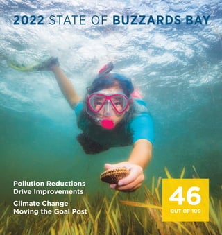
  • 1. 2022 STATE OF BUZZARDS BAY Pollution Reductions Drive Improvements Climate Change Moving the Goal Post 46 OUT OF 100
  • 2. www.savebuzzardsbay.org The Buzzards Bay Coalition is a membership-supported non-profit organization dedicated to the restoration, protection and sustainable use and enjoyment of Buzzards Bay and its watershed. Founded in 1987, the Coalition works to improve the health of the Bay ecosystem for all through education, conservation, research and advocacy. Learn more at: ON THE COVER Sunlight streaming through clear water to reach lush eelgrass beds and their resident bay scallops. It’s hard to imagine an image that better reflects a restored Buzzards Bay. Such a Bay is only possible with low pollution levels and healthy watershed forests, streams and wetlands. photo (cover and right): Romona Robbins 2015 2022 POLLUTION Nitrogen 53 57 Bacteria 62 59 Toxics 52 55 WATERSHED HEALTH Forests 77 76 Streams 71 71 Wetlands 60 59 LIVING RESOURCES Eelgrass 23 25 Bay Scallops 2 2 River Herring 2 1 OVERALL SCORE (100 = Excellent) 45 465 Improvement How We Create our Report To create the State of the Bay report, the Buzzards Bay Coalition collaborates with scientists and land use experts to examine the best available current and historical indicators in three categories: Pollution, Watershed Health, and Living Resources. Beginning in 2003, we have returned every few years to assess these same indicators as a consistent method for tracking progress or degradation over time. The current State of the Bay is measured against the healthiest Buzzards Bay in recorded history — the natural abundance experienced by explorer Bartholomew Gosnold and his crew in 1602. The Bay that Gosnold experienced was largely unspoiled by harmful human activities and rates 100 on our scale. Today, a restored, healthy Buzzards Bay would likely score a 75. In examining the best available information for each of the indicators, we actively seek additional data and more accurate sources of information to improve on this report on each iteration. The most reliable and consistent source of information is that collected through the Coalition’s own baywide Water Quality Monitoring Program, now in its 31st consecutive year. That data, collected in partnership with the Marine Biological Laboratory’s Ecosystems Center in Woods Hole, serves as the foundation of the Nitrogen Score. Originally planned as a 2020 report, the Covid-19 Pandemic delayed some important data sets upon which this report relies. NOAA and EPA mussel tissue data used to calculate the Toxic Score was delayed, but was ultimately acquired in 2022. The worst data loss came from the MA Department of Environmental Protection which has failed to update its analysis of wetlands loss for nine years now. That data had been expected in 2020, but was postponed during Covid and has yet to be released. We are grateful to all who contributed to this report. Joe Costa, Executive Director of the Buzzards Bay National Estuary Program helped with the Bacteria and Eelgrass scores this year. Paul Lefebvre, GIS Specialist at the Woodwell Climate Research Center, developed the Forest and Stream Buffer score. Chris Neill, Senior Scientist at the Woodwell Climate Research Center and Chair of the Coalition’s Science Advisory Committee, provided invaluable guidance and support. In addition, several agencies provided data for this report including the Massachusetts Division of Marine Fisheries, Massachusetts Department of Environmental Protection, US Environmental Protection Agency, National Oceanic and Atmospheric Administration, and Alewives Anonymous. John Rogan of Clark University’s Human-Environment Regional Observatory provided data on areas of forest cleared for solar development. The Chesapeake Bay Foundation’s annual State of the Bay report serves as a model for our report. Decline No Significant Change 2022 STATE OF BUZZARDS BAY Suggested Citation: Rasmussen, M., Jakuba, R.W., Costa, J.E., Lefebvre, P. (2022); 2022 State of Buzzards Bay. 12pp.
  • 3. Since the beginning of our State of the Bay reports in 2003, we have documented troubling trends in the health of Buzzards Bay. That year’s assessment yielded a score of 48 out of 100. Since then, the score has been stalled at 45 for the last three reports. In all those cases, the story behind that flat line remained the same: slow improvements in things like toxics and bacteria pollution were being eliminated by the impact of expanding nitrogen pollution. But then in 2015, nitrogen pollution stopped getting worse, and we stopped losing eelgrass beds as well. We hoped that this encouraging pause was signaling that we may have reached the floor on nitrogen pollution getting worse in the Bay. Pollution Reductions Are Driving Improvements … Six years on, the data on nitrogen pollution is even better than expected with the state of pollution in 2018 recovering to levels not seen since 1995 (before declining slightly in the next three years). This is not just great news for improved water clarity and healthy oxygen levels. The conditions created by reduced nitrogen pollution can also be seen in expansion of eelgrass beds throughout the Bay and even a bay scallop harvest in 2018-18 on a scale not seen in more than a decade. No other form of pollution does more harm to Buzzards Bay and all its harbors and coves than nitrogen, and its 4-point improvement in this State of the Bay should be celebrated. It is the result of years of local efforts to clean up septic systems and old sewer plants as well as state and federal gains in reducing the amount of nitrogen that falls on the Bay from air pollution. The other pollution reduction to be celebrated is the continued decline of toxics in the Bay. A 3-point improvement in the amount of toxins detected in the Bay’s delicate blue mussel populations is a result of the ongoing cleanup of legacy industrial pollution and modern restrictions on the use of toxics in agricultural, industrial and home products. … but Climate Change is Moving the Goal Post. Just when it looks like we’re beginning to address nitrogen pollution — the driving factor behind Bay declines over the past 30 years — climate change is moving the goal post and changing the Bay restoration landscape. Two factors that were not even recognized in the data when we started these assessments in 2003 are taking over as the greatest drivers of Bay decline — warmer water and rising sea levels. Warmer water in the Bay — up 4 degrees Fahrenheit since the mid 1990s — now allows bacteria to persist longer leading to shellfish bed and beach closures, and extends the season of biological activity in the Bay encouraging algae to bloom on lower levels of nitrogen. In effect, we need to remove more nitrogen in a warmer Bay to see the same water quality improvements. And rising sea levels are proving to be the Achilles heel of the Bay’s vital salt marshes, which are eroding and drowning under higher tides and higher base sea level. This is the most disappointing new challenge identified in these data. A final point. As a regional assessment, the State of Buzzards Bay scores can mask local variations in the data. Not all corners of the Bay improved and others, like the Westport River, saw exceptional gains. Improved 2022 State of Buzzards Bay score reflects significant reductions in nitrogen and toxic pollution, as well as new challenges facing the Bay due to climate change. 2022 STATE OF BUZZARDS BAY | 1 THE BOTTOM LINE
  • 4. Nitrogen 57 (+4 from 2015) No source of pollution has done more to damage the health of Buzzards Bay’s harbors, coves and tidal rivers over the past 40 years than nitrogen pollution. Between 1992 and 2013, nitrogen entering the Bay primarily from residential septic systems, but also from older wastewater treatment plants, air pollution from cars and power plants, and fertilizers, resulted in decreasing Bay Health scores documented by the Coalition’s Baywatchers Water Quality Monitoring Program. The downward trend pointed to a bleak future for our region’s coastal waters. And then, the decline slowed and there was enough optimism to label the status as an encouraging pause in nitrogen pollution in our 2015 State of the Bay report. The past six years have seen that ‘encouraging pause’ converted to a dramatic rally. In 2021, the baywide Nitrogen Score has made a 4-point improvement — the largest change in any of the State of the Bay indicators. Across the Bay, Nitrogen levels are down and water clarity and sunlight penetration are improved. Closely-related Eelgrass and Bay Scallop populations (discussed later in this report) have also benefitted. The score of 57 is based on the 5-year running average Bay Health Index scores across 180 locations from the Westport Rivers to Woods Hole representing the Bay’s major harbors, coves and tidal rivers. Between 2013 and 2018 there was a steady increase in water quality that then leveled over the last three years. As with any regional average, it is important to note that there are variations between embayments. Some places are doing worse, but many more are doing better. 2022 SCORE: Towns across the Bay are taking steps to reduce nitrogen pollution, and those actions are working to reverse the Bay’s decline. Since our last report, wastewater treatment plant upgrades in Marion and West Falmouth have been implemented, towns are doing more to require that new developments utilize the best nitrogen-removal technologies for septic systems, and cranberry farmers continue to improve bog construction methods and practices that reduce fertilizer losses. We have also benefitted from federal clean air policies which have dramatically reduced the amount of nitrogen compounds (i.e., nitrous oxides and ammonia) falling on the Bay from car exhaust pipes and old fossil fuel power plants (see graph). The last coal-fired power plant in Massachusetts located at Brayton Point in Somerset, just 5 miles from the western edge of the Buzzard Bay watershed, was shut down in 2017 ending more than 50 years of pollution entering the Bay. H o w i s N i t r o g e n A f f e c t i n g Y o u r L o c a l H a r b o r o r C o v e ? B a y H e a l t h I n d e x ( 5 - y r r u n n i n g a v e r a g e ) D e g r a d e d N a s k e t u c k e t R i v e r E s t u a r y A c u s h n e t R i v e r E s t u a r y S n u g H a r b o r , W e s t F a l m o u t h I n n e r S l o c u m s R i v e r W e s t p o r t R i v e r , U p p e r E a s t B r a n c h A g a w a m R i v e r E s t u a r y I n n e r W e w e a n t i c R i v e r M a t t a p o i s e t t R i v e r M o u t h I n n e r L i t t l e R i v e r I n n e r A p p o n a g a n s e t t B a y I n n e r A u c o o t C o v e W e s t p o r t R i v e r , I n n e r E a s t B r a n c h R a n d s H a r b o r E e l P o n d , M a t t a p o i s e t t O u t e r L i t t l e R i v e r E e l P o n d , B o u r n e W e s t E n d P o n d , C u t t y h u n k H a m m e t t C o v e O u t e r W e w e a n t i c R i v e r I n n e r N e w B e d f o r d H a r b o r W i l d H a r b o r R i v e r B r o a d M a r s h R i v e r B a c k R i v e r I n n e r P o c a s s e t H a r b o r P o c a s s e t R i v e r I n n e r W a r e h a m R i v e r W e s t F a l m o u t h H a r b o r H e a d L i t t l e S i p p e w i s s e t t M a r s h A p p o n a g a n s e t t B a y , M i d - H a r b o r I n n e r S i p p i c a n H a r b o r O u t e r S l o c u m s R i v e r POOR FAIR 2 | BUZZARDS BAY COALITION POLLUTION BAY-WIDE NITROGEN SCORE 2021 2015 1 0 1 7 2 5 2 4 1 9 4 1 2 8 3 4 3 2 3 0 3 9 2 5 4 5 2 6 3 8 4 2 4 3 3 3 4 5 4 5 4 1 4 9 3 7 6 2 5 2 5 3 3 7 4 4 4 8 5 1 4 8 3 1 7 2 5 2 7 2 8 2 8 2 9 2 9 3 1 3 4 3 5 3 6 3 9 4 0 4 0 4 0 4 1 4 2 4 2 4 3 4 8 4 8 5 0 5 0 5 1 5 1 5 3 5 3 5 3 5 3 5 5 70 65 60 55 50 45 40 1 9 9 0 1 9 9 5 2 0 0 0 2 0 0 5 2 0 1 0 2 0 1 5 2 0 2 0 2 0 2 5 2003 2021 2013
  • 5. difference. The trend in chlorophyll concentrations, however, indicates that while water quality responded to decreases in nitrogen, chlorophyll concentrations have remained higher than they were at similar nitrogen concentrations 20 years ago, which shows the challenge that climate change poses. Higher bay water temperatures help to fuel algal blooms and keep dissolved oxygen concentrations lower, so nitrogen concentrations will need to keep declining if we are to restore water quality. In essence, climate change is moving the goal post on Bay recovery. In a world of warmer water, more nitrogen pollution must be removed from the Bay to get the related positive responses in lower algae (clearer water) and greater oxygen (more fish and shellfish) than before. There is an up to 10-year lag between reductions in emissions from the source and improved water quality in nearby waterways. Adapted from Lloret et al. 2022 (doi.org/10.1016/j.ecss.2022.108057) Today, by far the largest source of nitrogen to most Buzzards Bay harbors and coves remains residential septic systems. Even new, properly functioning Title 5 septic systems do little to prevent nitrogen pollution. Much work lies ahead to connect more homes to modern wastewater treatment plants, and where that’s not possible, to enhanced nitrogen- reducing septic systems. The nitrogen data also contain a warning for the future. Chlorophyll concentrations (a measure of algae in the water) in the Bay were the highest ever recorded between 2005 and 2013 and while somewhat lower since 2014, they are generally still higher than the first ten years of the Baywatchers Program. This observation is a reason for concern. The steady decrease in nitrogen concentrations shows clearly that we can make a O u t e r N e w B e d f o r d H a r b o r L i t t l e B a y , F a i r h a v e n I n n e r W i l d H a r b o r H e n C o v e O u t e r A p p o n a g a n s e t t B a y S q u e t e a g u e H a r b o r W e s t p o r t R i v e r , W e s t B r a n c h O u t e r W a r e h a m R i v e r L i t t l e B u t t e r m i l k B a y F i d d l e r s C o v e I n n e r R e d B r o o k H a r b o r S h e l l P o i n t B a y , O n s e t M a r k s C o v e W e s t F a l m o u t h H a r b o r , M i d - H a r b o r I n n e r M a t t a p o i s e t t H a r b o r I n n e r C l a r k s C o v e O u t e r S i p p i c a n H a r b o r W e s t p o r t R i v e r , O u t e r E a s t B r a n c h O u t e r C l a r k s C o v e B u t t e r m i l k B a y P h i n n e y s H a r b o r E a s t R i v e r , O n s e t B l a n k e n s h i p C o v e O u t e r W e s t F a l m o u t h H a r b o r I n n e r O n s e t B a y O u t e r R e d B r o o k H a r b o r O u t e r P o c a s s e t H a r b o r N a s k e t u c k e t B a y A u c o o t C o v e , M i d - H a r b o r O u t e r M a t t a p o i s e t t H a r b o r H i l l e r s C o v e W e s t p o r t R i v e r I n l e t M e g a n s e t t H a r b o r O u t e r O n s e t B a y O u t e r A u c o o t C o v e C u t t y h u n k P o n d I n n e r Q u i s s e t t H a r b o r P e n i k e s e I s l a n d O u t e r Q u i s s e t t H a r b o r H e a l t h y EXCELLENT FAIR 2022 STATE OF BUZZARDS BAY | 3 5 0 6 9 4 6 5 1 5 7 5 7 4 7 6 0 5 7 6 1 4 3 5 8 6 4 6 1 6 3 4 3 6 4 5 1 5 6 6 2 6 6 6 7 7 0 6 4 7 0 5 6 7 7 7 8 7 4 7 5 8 0 6 4 7 2 7 6 7 7 8 1 8 0 9 6 8 6 5 6 5 6 5 7 5 7 5 7 5 8 5 9 6 0 6 1 6 1 6 3 6 3 6 3 6 5 6 6 6 7 6 7 6 8 6 9 6 9 6 9 7 2 7 2 7 4 7 5 7 6 7 6 7 6 7 7 7 7 8 1 8 2 8 3 8 3 8 4 8 6 8 9 9 0 9 1 20 15 10 5 0 TOTAL N DEPOSITION (kg N ha -1 yr -1 ) 1 9 7 0 1 9 8 0 1 9 9 0 2 0 0 0 2 0 1 0 2 0 2 0 Massachusetts Cape Cod DECLINES IN NITROGEN IN AIR POLLUTION
  • 6. 4 | BUZZARDS BAY COALITION Bacteria 59 (-3 from 2015) Toxics 55 (+3 from 2015) Since the early-1990s, communities around the Bay have worked hard to improve sewage treatment, identify illegal septic hookups, and tie more homes into municipal wastewater plants. As a result, today our swimming beaches are much safer, and more shellfish beds are open to harvest. But the work is far from complete — and becoming more challenging. A 3-point drop in the Bacteria score is the largest ever reported and marks a troubling new challenge facing all corners of the Bay. A near steady source of improve- ment between 1990 and 2010, the trend of reopening shellfish beds has reversed over the past four years. Our bacteria score is calculated by tracking the number of acres of shellfish beds closed to harvest on July 1st of every year. Between 2015 and 2021, the number of acres open on that day has declined by 1,656 acres. Most notable is that this drop in score does not appear to be due to actual increases in the discharge of bacterial contamination. The decline in score is partially due to more stringent federal regulation that now requires closing more shellfish beds around marinas and mooring fields as a precaution. This change accounts for 56% of the increased closures. A second reason is more of a concern. The combination of continued nitrogen pollution now exacerbated by ever warmer water in the Bay helps bacteria persist longer than before. We see the same effect at play in what are now more frequent late summer beach closures when the Bay is at its warmest. This is another case of climate change moving the goalpost. Greater reductions of pollution are now required to produce water quality benefits. The reduction of toxic pollution continues to be one of the brightest spots in this year’s State of Buzzards Bay report thanks to stricter laws, improving farming and industrial technologies, and better enforcement. Sources of toxic pollution to Buzzards Bay include oil spills, discharges from wastewater treatment plants, household hazardous wastes, pesticides, and stormwater runoff. In addition, “legacy” contaminants — pollution from past practices like the dumping of PCBs in New Bedford Harbor from 1950-1980 — continue to demand cleanup attention and funding. To assess the extent of toxic pollution in the Bay, we use data collected from blue mussels which easily absorb and bioaccumulate toxics and reflect the quality of the waters surrounding them. Our score is based on a combination of monitoring of PCBs in mussels in New Bedford Harbor by the US EPA (25%) and the NOAA Mussel Watch Program’s monitoring of 42 different contaminants (10 metals, 16 PAHs, 16 organochlorine pesticides) at locations throughout Buzzards Bay (75%). In this year’s assessment, the New Bedford Harbor PCB portion of the score improved, but the increase was not as large as it was between either of the two previous reports in 2011 and 2015. The most recent data available from EPA, however, was from 2018, and removal of contaminated sediments in the Harbor has accelerated due to federal Covid recovery funding in recent years. The level of toxic pollution elsewhere in Buzzards Bay remains much lower. 2021 Mussel Watch data were analyzed from sampling stations at the Cape Cod Canal, off West Falmouth, and at Gooseberry Island in Westport. Levels of pollution in the metals class remained the same over our 2015 report, but reductions in the levels of PAHs (from burning of coal, oil and gasoline) and organochlorine pesticides (historically used in agriculture) drove the improvements. BUZZARDS BAY SHELLFISH CLOSURES, JULY 1 ACRES CLOSED 14,000 12,000 10,000 8,000 6,000 4,000 2,000 0 1 9 9 1 1 9 9 3 1 9 9 5 1 9 9 7 1 9 9 9 2 0 0 1 2 0 0 3 2 0 0 5 2 0 0 7 2 0 0 9 2 0 1 1 2 0 1 3 2 0 1 5 2 0 1 7 2 0 1 9 2 0 2 1 Closures increased all years since 2015. 2022 SCORE: 2022 SCORE:
  • 7. Forests 76 (-1 from 2015) WATERSHED HEALTH 2022 STATE OF BUZZARDS BAY | 5 Compared to other East Coast estuaries like Narragansett Bay (42% forested), Long Island Sound (56%) and the Chesapeake (60%), Buzzards Bay has an important distinction: its large area of watershed forest. The simple fact that 76% of our watershed remains forested is one of the key secrets behind the Bay’s relative good health. The 2022 forest score of 76 represents a decline of one point over 2015. A disappointing 1,863 acres of forest were lost to development since our last report. Land Use analysts at the Woodwell Climate Research Center utilized aerial imagery to determine the extent of forest in our region at an extremely high level of resolution. Forests protect clean water in our bay, streams, ponds and drinking water supplies in countless ways. The soils in forests capture rainfall, filtering out harmful pollution before slowly releasing the water into streams, wetlands and groundwater. Tree roots hold soil in place preventing erosion and sediment pollution. And, forests store carbon, keep our air clean and cooler, and shade coldwater streams where native brook trout and other wildlife thrive. Of the 1,863 acres of forest lost to development since 2014, two-thirds of the loss was attributed to largely low density, sprawl residential development fueled by the hottest real estate market in a decade. The other one-third — 604 acres — was destroyed by a frustrating new practice in our watershed — the clearing of mature forest for solar farms. The production of renewable energy from solar photovoltaics is an important part of decreasing dependence on fossil fuels and fighting climate change. But clearing Bay-saving forests is not the way forward when our region is full of alternative, already altered sites. Stream Buffers 71 no change No part of our landscape contributes more to protecting clean water than Stream Buffers - the forested areas that grow along the more than 700 miles of streams flowing through the Buzzards Bay watershed. The first 200 feet of trees and plants along either side of a stream are the most important to protect due to their ability to capture, absorb and remove an amazing amount of pollution before it ever reaches our waterways. The Stream Buffer score remains steady at 71, meaning that local Conservation Commissions in all Bay towns continue to hold their own to prevent development within 200 feet of the Bay’s small streams. Between 2014-2021, just 52 acres of natural cover was lost in this critical band throughout the Bay watershed. 42% of the loss (22 acres) of Stream Buffer over that period was due to solar development. As housing developments, farms and commercial buildings have replaced natural stream buffers, the health of our water has suffered. Between 1620-1995, 29% of Buzzards Bay’s watershed stream buffers — nearly 9,000 acres — were lost to poorly planned development. The relative success in maintaining our Stream Buffer area over the past 25 years can be largely attributed to the MA Rivers Protection Act — a targeted amendment to the state Wetlands Act. Under the law, the first 100 feet along streams are usually protected, the second 100 feet require permitting but can continue to face development pressure. Local Conservation Commissions in all Bay towns administer this law on a project-by-project basis. 2022 SCORE: 2022 SCORE:
  • 8. Wetlands 59 (-1 from 2015) No component of the Bay ecosystem assessed by this report is under more pressure and accelerating decline than the Bay’s wetlands. Overall, an estimated 40% of the Bay’s original wetlands have been filled, drained, or built upon since European settlement. These rich habitats are powerful pollution filters that can absorb as much as 90% of the nitrogen flowing across the landscape from nearby development. They are, in effect, the Bay’s kidneys — and we can’t afford to lose any more of them. Layers of local, state, and federal laws overlap to protect the Bay watershed’s salt marshes, wooded swamps, and freshwater wetlands. Nevertheless, between 1997-2012 we lost 265 acres of wetlands at an average annual rate of 10-14 acres since 2001. The MA DEP issued an analysis of wetland destruction every 3-4 years during that time, but has failed to produce a new analysis for the past nine years. Carrying forward that previous loss rate, it’s pos- sible that an additional 90-125 acres of wetlands were lost due to traditional land development in that period. The most serious and troubling losses of wetlands today, however, no longer come from bulldozers and backhoes. A new silent form of human destruction is taking our most precious wetlands — our salt marshes — away from us. Climate change-driven sea level rise is literally drowning salt marshes in place and already at an alarming rate. These factors produced the first 1-point drop in the Wetlands score in the assessment’s history. Of the Bay’s nearly 5,000 acres of saltmarsh, approximately 7% of them — were lost between 2001 and 2019. This new data are not a projection, but rather the real-world findings at twelve study sites — from Westport to Falmouth — featuring a wide range of marsh configurations. Some marshes studied, like those on Mattapoisett Neck, saw dramatic losses of 23% of their area. The terrible driver here is accelerating sea level rise and it will only get worse in the decades ahead. The official Massachusetts Coastal Flood Risk Model projects that sea-level in the Bay will increase by 1.27 feet over 2008 levels by 2030; 2.57 feet by 2050; and nearly 8 feet by 2100. Under these water levels, analysis contained in the 2022 State of the Coast report by The Trustees of Reservations projects that by 2050 Westport will lose 48% of its salt marshes (including all its island marshes), Dartmouth 30%, Bourne 28%, Marion 21%, and Mattapoisett and Falmouth 17% each. Scientists and natural resource managers across southern New England are scrambling right now to identify stop-gap measures that can be deployed to slow the rate of salt marsh loss and to preserve immediately adjacent coastal areas where marshes may migrate inland as the sea rises. These efforts are vital, but not as important as halting the world’s reliance on fossil fuels which continues to destroy the Bay ecosystem. 10 | BUZZARDS BAY COALITION 8 | BUZZARDS BAY COALITION 6 | BUZZARDS BAY COALITION 2022 SCORE:
  • 9. Eelgrass 25 (+2 from 2015) LIVING RESOURCES If you want to track the spread of nitrogen pollution in your own corner of Buzzards Bay, watch the eelgrass. This rooted, underwater plant grows in meadows along the bottom of the Bay’s harbors, coves and tidal rivers in areas with clear water. But when nitrogen pollution increases, it fuels the growth of algae that reduces water clarity. Without enough sunlight reaching the bottom, eelgrass dies — just like a shaded house plant. And those species that depend on eelgrass — juvenile fish, blue crabs, and bay scallops — begin to vanish too. But when water quality improves, eelgrass has consistently shown its ability to naturally recover. Like the 2021 Nitrogen Pollution score, eelgrass coverage increased by 2 points in the past six years. Overall, eelgrass meadows in Buzzards Bay increased 552 acres between 2015 and 2021. The change was documented through analysis by the Buzzards Bay National Estuary Program of maps of eelgrass created from aerial images and field confirmation by MassDEP. There are a few areas that stand-out in this eelgrass recovery story. Most notable, more than half of all new eelgrass acres resulted from a dramatic expansion in the Westport Rivers, particularly in the West Branch which added 201 acres. And, a fifth of new eelgrass since 2015 occurred along the coast just outside of embayments where depths remain shallow, but water quality benefits more from open exchange with the cleaner open bay. The area of greatest eelgrass decline was in Mattapoisett Harbor which has lost 51 acres since 2015. 0 2,500 5,000 7,500 10,000 12,500 15,000 0 3,000 6,000 9,000 1 9 9 6 1 9 9 8 2 0 0 0 2 0 0 2 2 0 0 4 2 0 0 6 2 0 0 8 2 0 1 0 2 0 1 2 2 0 1 4 2 0 1 6 2 0 1 8 2 0 2 0 2 0 2 2 BUSHELS ACRES Eelgrass coverage Bay scallops catch 51 YEARS OF EELGRASS AND BAY SCALLOPS (1970-2021) 2022 STATE OF BUZZARDS BAY | 7 2022 SCORE:
  • 10. 10 | BUZZARDS BAY COALITION Bay Scallops 2 no change Bay scallops were to Buzzards Bay what oysters historically were to New York Harbor and the Chesapeake. But today, our once-abundant and highly-valuable bay scallops have all but disappeared from most parts of Buzzards Bay. The Bay Scallop score was unchanged from 2015 and 2021. The Massachusetts Division of Marine Fisheries reported an average catch of roughly 1,300 bushels per year. That’s a stunning decline from 1985, when nearly 70,000 bushels were harvested in Buzzards Bay. But the story behind these deliciously fickle shellfish over the past six years holds a glimmer of hope. As the graph on previous page shows, bay scallops are notorious for their natural boom and bust cycle, with banner harvest years followed by years of almost no catch. As populations have crashed over the past 35 years, harvests have remained consistently low. That was, until 2017 when 4,675 bushels were landed, followed by 2,430 bushels in 2018. Those harvests coincide with eelgrass recovery over the same time period as these two species are closely linked. Bay scallops live and grow among the shelter of eelgrass meadows and are dependent on them for their survival. Despite that brief flash of promise, State shellfish catch records for 2020 and 2021 ominously show zero landings of bay scallops for the first time ever for Buzzards Bay. Something good happened in the West Branch… again. Between 2015 and 2021, 305 acres, or 55% of all new eelgrass growth in Buzzards Bay, came from the Westport Rivers, particularly the West Branch which accounted for 201 of those acres. This rapid expansion of eelgrass meadow correlates with the 2017-19 bay scallop harvests — the best in 18 years. In fact, the MA Division of Marine Fisheries reports that 95% of all bay scallop catch in Buzzards Bay for those years was out of Westport. And it’s not the first time that an unexpected boom year came out of the West Branch or Westport carried regional bay scallop landings. The last large bay scallop harvest in the Bay was in 1985 when 66,169 bushels were landed. That harvest followed a similar rapid expansion of eelgrass in the West Branch. A 1988 scientific paper reported,“The cause of this recent recolonization (in the West Branch) is unclear, and this estuary has undergone sizable fluctuations in eelgrass abundance in the past. These new beds accounted for at least a 30% increase in eelgrass cover in this estuary over one year… Two years after the 1984 eelgrass expansion scallop catches were the best in many years.” (From Costa 1988) 8 | BUZZARDS BAY COALITION 8 | BUZZARDS BAY COALITION Eelgrass recovery in the West Branch of the Westport River 2022 SCORE:
  • 11. River Herring 2 no change But there are signs that count trends on the Mattapoisett may not be tracking the modest recovery being seen on other Buzzards Bay rivers such as the Monument (Cape Cod Canal) and Agawam River (see graph). Nearby on the Taunton River and Cape Cod there are also strong glimmers of hope. On the Herring River in Harwich, Selectmen this year voted to lift the 18-year moratorium on herring catch after seeing a remarkable 1.2 Million fish counted there in 2019 — restored to a third of its historic run size. This action followed a similar step taken in 2016 in Middleboro on the Nemasket River — the largest run in the state — following a number of high-count years. River herring in Buzzards Bay remain in a state of profound collapse with serious consequences for the Bay ecosystem. Today, only a tiny fraction of the historic numbers of River Herring still make the journey from offshore, into the Bay, and upstream to spawn in the watershed’s freshwater rivers and ponds. This is very bad news for the Bay’s sportfish such as Striped Bass and Bluefish that rely on herring as well as for many bird species including the region’s endangered Roseate Terns. River herring, as a “foundation fish” at the base the food chain, provide an important pillar in the Bay ecosystem. And today that pillar remains in desperate need of rebuilding. The historic decline of Buzzards Bay’s anadromous fish like river herring can be traced first to the damming of the Bay’s rivers, which prevent fish from swimming upstream, but also to water quality degradation, alterations to pond and stream flows, and offshore bi-catch by commercial menhaden, mackerel and Atlantic herring fishermen. A likely increasing challenge in years ahead are the extreme drought years that we are now experiencing due to climate change. Low water levels caused many Bay streams to run dry in late summer 2022 just as juvenile herring born upstream are making their transition to saltwater. With one of the longest datasets available, the Mattapoisett River has served as our regional benchmark for tracking the state of river herring throughout Buzzards Bay. In 1921, state biologists estimated the river’s run at 1.85 Million fish. One Hundred years later, that figure sits at 1,886 fish — the lowest annual count ever recorded. To put a finer point on these figures, fish in the Mattapoisett are 0.001% of the count made exactly a century ago. COUNTS ON THE BAY’S LARGEST HERRING RIVERS (2007-2022) 700,000 600,000 500,000 400,000 300,000 200,000 100,000 0 2 0 0 7 2 0 0 8 2 0 0 9 2 0 1 0 2 0 1 1 2 0 1 2 2 0 1 3 2 0 1 4 2 0 1 5 2 0 1 6 2 0 1 7 2 0 1 8 2 0 1 9 2 0 2 0 2 0 2 1 2 0 2 2 Mattapoisett River Agawam River Monument River 2022 SCORE:
  • 12. Cleanup Wastewater Nitrogen and bacteria pollution are both rooted in inadequate residential wastewater treatment. Nearly 2/3 of homes around the Bay are served by septic systems which are not designed to remove nitrogen pollution. It is the pollution from these homes — from us and our neighbors — at the root of the Bay’s problems. What Can Be Done: · Connect existing and new homes to central Wastewater Treatment Plants (WWTP). Modern WWTPs consistently remove >90% of nitrogen pollution and represent the best solution available to our communities. · Where central sewer systems are not possible, such as in lower-density suburban and rural areas, upgrade homes to individual Denitrifying Septic Systems which remove >50% of nitrogen. · Wastewater infrastructure is expensive. Support your town officials in long-term financial planning and advocate for grant funding from state and federal agencies. Preserve Forests and Wetlands Preservation of the Bay watershed’s most important forests, stream corridors and wetlands is the most cost effective way to protect the health of Buzzards Bay as well as our drinking water. These are the Bay’s natural filter systems and they demand active effort to protect them in the face of land development pressures. What Can Be Done: · Support your town’s active participation in and funding of open space preservation. · Town Conservation Commissions and the MA DEP must enforce existing wetlands and river protection laws. DEP’s release of updated Wetlands Loss analysis is critical to tracking compliance. · State laws and local zoning should be amended to redirect solar developments away from forests to already disturbed and built areas. Taking Action to Improve the State of Buzzards Bay Address Climate Change So much of what needs to happen to restore the Bay is controlled locally. Wastewater and land use decisions happen each week at our own Town Halls. While that is not the case with curbing Climate Change, we all must do our part to prevent the warming and sea level rise that is exacerbating nitrogen and bacteria pollution in the Bay, devastating our vital salt marshes and altering flows in our streams. We all must accelerate our community’s transition away from the burning of fossil fuels and support clean, renewable energy development. MAIN OFFICE 114 Front Street, New Bedford, MA 02740 Join us and get involved at www.savebuzzardsbay.org Middleborough Lakeville Freetown Fall River Tiverton Carver Plymouth Westport Westport R. Little Compton East Branch West Branch Dartmouth Apponagansett Bay Slocum R. Cuttyhunk Is. Clarks Cove New Bedford Acushnet R. New Bedford Inner Harbor Fairhaven Acushnet Naushon Is. Mattapoisett R. Mattapoisett Mattapoisett Harbor Nasketucket Bay Rochester Weweantic R. Marion Aucoot Cove Sippican Harbor Wareham R. Wankinco R. Wareham Agawam R. Onset Bay Buttermilk Bay Cape Cod Bay Buzzards Bay Watershed Boundary Cape Cod Canal Falmouth Bourne Woods Hole Gosnold Back R. Pocasset R. Wings Cove Red Brook Harbor Wild Harbor R. Quissett Harbor West Falmouth Harbor Wild Harbor Herring Brook Sandwich Quicksand Pond B U Z Z A R D S B A Y V I N E Y A R D S O U N D A few things everyone can do right now: · Get involved in town government: Volunteer to serve on Select, Planning, Conservation and Health boards, vote at Town Meeting, comment on projects that affect the local environment. · If a sewer connection is not possible in your area, plan for the upgrade of your own home septic system to one that removes nitrogen. · Reduce your use of lawn fertilizers and only use organic garden products. · Never dump paint, oil, cleaners or other hazardous waste down sinks or storm drains. · If you own undeveloped land, talk with the Buzzards Bay Coalition or a local land trust about conservation options. · Avoid eelgrass beds and sensitive salt marsh edges when boating and shellfishing.